Logan, Spokane
Logan | |
|---|---|
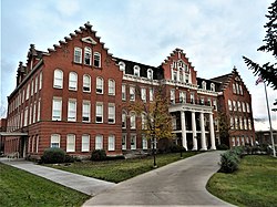 Holy Names Academy Building, on the NRHP, in Logan. | |
| Coordinates: 47°40′29.2″N 117°23′47.6″W / 47.674778°N 117.396556°WCoordinates: 47°40′29.2″N 117°23′47.6″W / 47.674778°N 117.396556°W | |
| Country | United States |
| State | Washington |
| County | Spokane |
| City | Spokane |
| Population (2017 [1]) | |
| • Total | 10,831 |
| Demographics 2017 | |
| • White | 82.1% |
| • Black | 3.2% |
| • Latinx | 7.2% |
| • Asian | 4.9% |
| • Native American | 2% |
| Time zone | UTC-8 (PST) |
| • Summer (DST) | UTC-7 (PDT) |
| ZIP Codes | 99202, 99207 and 99258 |
| Area code(s) | 509 |

Logan is a neighborhood in Spokane, Washington. It is located immediately northeast of Downtown Spokane and is home to Gonzaga University. The Spokane River runs along its eastern and southern edge. Due to its proximity to the city center, Logan is home to some of the oldest and densest areas in the city. It is known for its tree-lined streets, historic buildings and population of college students.
Geography[]
Logan is one of the central neighborhoods in Spokane, being located immediately adjacent to downtown and the rest of the city center. The Spokane River flows past Logan, first along the eastern edge of the neighborhood before turning to the west and providing the southern boundary. A stretch of Spokane Falls Boulevard and Trent Avenue act as the southern border of the neighborhood as well. Division Street, which carries U.S. Route 2 and serves as a major north-south thoroughfare in the city, serves as the western boundary. Euclid Avenue is the northern limit, from Division to Napa Street, though Illinois Avenue serves as that boundary from Napa to Crestline Street.[2]

The Spokane River Centennial Trail passes through Logan.[2]
Mission Avenue passes through Logan as a tree-lined boulevard from Division Street on the west all the way to Mission Park on the east side of the neighborhood. Mission, along with Spokane Falls Boulevard, Sharp Avenue, Indiana Avenue and North Foothills Drive, are east-to-west arterials in Logan. The Division and Ruby Street couplet on the west edge of the neighborhood, and Hamilton Street passing through the heart of Logan, serve as arterials for north-to-south travel. Pedestrian crossings of the Spokane River are located at Division, the Spokane River Centennial Trail, Spokane Falls Boulevard, Trent Avenue, Iron Bridge and Mission Avenue.
Higher education dominates the geography of the southern half of Logan. The campus of Gonzaga University stretches from the Spokane River on the south to Sharp on the north and Ruby on the west to Hamilton on the east. A handful of campus buildings are located north of Sharp and east of Hamilton.[3] Gonzaga's campus forms the northern half of University District, which extends south of Logan to the Spokane campuses of Washington State University and Eastern Washington University.[4]
To the north and east of Gonzaga's campus lie the tree-lined, residential sections of the Logan neighborhood. The historic character fades as you reach the northern edge of the neighborhood, however, and residential areas transition into commercial and light-industrial zones.[5]
Hamilton Street serves as the neighborhood's main commercial and retail district. Zoned as part of Spokane's "centers and corridors" plan, higher density buildings are allowed on Hamilton than elsewhere in the neighborhood.[5] The stretch of Hamilton nearest Gonzaga's campus is home to most of the neighborhoods bars and restaurants, giving the area a college town kind of atmosphere. Jack and Dan's, a landmark Spokane bar in continuous operation since the end of prohibition, is located at Hamilton and Sharp. Formerly owned by John Stockton's father, the eponymous Jack Stockton, the bar has many ties to the Gonzaga community and is frequently mentioned during television broadcasts of Gonzaga basketball games.[6]
The terrain is mostly flat, though the northernmost edge of the neighborhood lies on a relatively steep incline leading up to the aptly named North Hill neighborhood.
History[]

Initially platted between 1884 and 1889, Logan is one of the oldest neighborhoods in Spokane. It was developed initially as a suburb of nearby downtown Spokane with wide streets and landscaped boulevards. Gonzaga University, then known as Gonzaga College, was established in the neighborhood in 1887. Water and electricity from the City of Spokane arrived in 1892.[7]
Logan is home to numerous properties on the Spokane Register of Historic Places.[8] The neighborhood has many homes built in the early 1900s displaying the Queen Anne, Craftsman, Foursquare and Bungalow architectural styles. The Mission Avenue Historic District, which stretches for six blocks on Mission Avenue in Logan, is home to a high density of these historic homes. The district is on the National Register of Historic Places.[8]
The growth of Gonzaga University since the men's basketball team's Cinderella run to the Elite Eight of the 1999 NCAA Tournament has led to considerable change and new development in Logan. In the first years of the 2000s, much of the change took place off-campus, as the swelling student body expanded into rental housing off-campus.[9] The physical nature of the neighborhood has changed as well, with construction of numerous new facilities and buildings on and around Gonzaga's campus over the years since 1999.[10] This growth and expansion continues to the present, with Gonzaga involved in two construction projects as of 2021 worth a combined $116 million.[11]
Demographics[]
As of 2017, 10,831 people lived in Logan across 3,349 households, 19% of which were households with children. People age 19 and under accounted for 28.7% of the population while those 65 and above accounted for 9.6% of residents. The former is above the citywide average and the latter is below. The median household income was $35,296, below the citywide average, and the percentage of children who qualified for free or reduced school lunch was 89.1%, well above the citywide average. 70.6% of households are rentals.
References[]
- ^ "Logan Neighborhood Snapshot" (PDF). spokanecity.org. City of Spokane. Retrieved 28 October 2021.
- ^ a b "Logan Map" (PDF). spokanecity.org. City of Spokane. Retrieved 28 October 2021.
- ^ "Main Campus Map". gonzaga.edu. Gonzaga University. Retrieved 28 October 2021.
- ^ "Map | The University District". spokaneudistrict.org. Spokane University District. Retrieved 28 October 2021.
- ^ a b "City of Spokane Current Zoning" (PDF). spokanecity.org. City of Spokane. Retrieved 28 October 2021.
- ^ Pettit, Stefanie (31 January 2013). "Landmarks: Jack and Dan's has deep roots in Gonzaga district". The Spokesman-Review. Retrieved 28 October 2021.
- ^ "Logan Neighborhood Profile" (PDF). spokanecity.org. City of Spokane. Retrieved 28 October 2021.
- ^ a b "Historic Properties of Spokane". historicspokane.org. City - County of Spokane Historic Preservation Office. Retrieved 28 October 2021.
- ^ Whitney, Michael (13 October 2004). "Growth of GU felt in Logan Neighborhood". The Gonzaga Bulletin. Retrieved 28 October 2021.
- ^ "GU History: 2000-Present". gonzaga.edu. Gonzaga University.
- ^ Parish, Lynn (26 March 2020). "Gonzaga is involved in two projects worth $116M". Spokane Journal of Business. Retrieved 28 October 2021.
Places adjacent to Logan, Spokane | ||||||||||||||||
|---|---|---|---|---|---|---|---|---|---|---|---|---|---|---|---|---|
| ||||||||||||||||
This article needs additional or more specific categories. (October 2021) |
- Neighborhoods in Spokane, Washington
- Geography of Spokane, Washington