Lot 3, Prince Edward Island
Lot 3, Prince Edward Island | |
|---|---|
Township | |
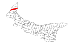 Map of Prince Edward Island highlighting Lot 3 | |
| Coordinates: 46°53′N 64°7′W / 46.883°N 64.117°WCoordinates: 46°53′N 64°7′W / 46.883°N 64.117°W | |
| Country | Canada |
| Province | Prince Edward Island |
| County | Prince County |
| Parish | North Parish |
| Area | |
| • Total | 86.81 km2 (33.52 sq mi) |
| Population (2006) | |
| • Total | 899 |
| • Density | 10.4/km2 (27/sq mi) |
| Time zone | UTC-4 (AST) |
| • Summer (DST) | UTC-3 (ADT) |
| Canadian Postal code | C0B |
| Area code(s) | 902 |
| NTS Map | 021I16 |
| GNBC Code | BAEQP |

Lot 3 is a township in Prince County, Prince Edward Island, Canada created during the 1764–1766 survey of Samuel Holland. It is part of North Parish.
Population[]
- 899 (2006 census)
- 864 (2001 census)
- 893 (1996 census)
Communities[]
Incorporated municipalities:
- Greenmount-Montrose
Civic address communities:
- Alma
- Central Kildare
- Elmsdale
- Greenmount
- Huntley
- Kildare Capes
- Lauretta
- Montrose
- Roseville
- St. Edward
- St. Lawrence
- Woodvale
History[]
The township went through various owners under feudalism when Prince Edward Island was a British colony prior to Canadian Confederation:
- Chauncy Townsend, Esq. (M.P.).[1] (1767-1810)
- Various.[2] (1838)
- Benj. Bowring, Esq., Jas. Yeo, Esq., and others.[3] (1864)
| Subdivisions | |
|---|---|
| Cities | |
| Towns | |
| Rural municipalities |
|
| Resort municipalities | |
| Unincorporated communities | |
| Townships | |
| |
This Prince Edward Island location article is a stub. You can help Wikipedia by . |
Categories:
- Townships of Prince Edward Island
- Geography of Prince County, Prince Edward Island
- Prince Edward Island geography stubs