Luzit
Luzit
לוזית لوزيت | |
|---|---|
 | |
 Luzit | |
| Coordinates: 31°41′6″N 34°53′11″E / 31.68500°N 34.88639°ECoordinates: 31°41′6″N 34°53′11″E / 31.68500°N 34.88639°E | |
| Country | Israel |
| District | Jerusalem |
| Council | Mateh Yehuda |
| Affiliation | Moshavim Movement |
| Founded | 1955 |
| Founded by | North African Jews |
| Population (2019)[1] | 816 |

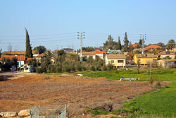
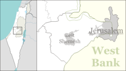
Luzit (Hebrew: לוּזִית, lit. Almond Tree) is a moshav in central Israel. Located between Beit Shemesh and Kiryat Gat, it falls under the jurisdiction of Mateh Yehuda Regional Council. In 2019 it had a population of 816.[1]
History[]
The village was established in 1955 by Sephardic Jewish immigrants and refugees from North Africa, led by Shalom de Palenzuela Levi-Kahana and was initially named Dir Duban Bet after the depopulated Arab village of Deir al-Dubban. It was later renamed Luzit after almond trees, which are common in the area.
References[]
- ^ a b "Population in the Localities 2019" (XLS). Israel Central Bureau of Statistics. Retrieved 16 August 2020.
Categories:
- Mateh Yehuda Regional Council
- Moshavim
- Populated places established in 1955
- Populated places in Jerusalem District
- 1955 establishments in Israel
- North African-Jewish culture in Israel