MBTA crosstown bus routes

The Massachusetts Bay Transportation Authority (MBTA) operates two specially designated crosstown bus routes in the Boston, Massachusetts, United States area, called CT2 and CT3, and intended as limited-stop buses connecting major points. The two weekday-only routes largely parallel MBTA bus local routes, but with fewer stops to reduce travel times.
Three crosstown routes – CT1, CT2, and CT3 – were introduced in 1994.[1] Eight additional routes numbered CT4 through CT11 were proposed as part of an interim phase of the Urban Ring Project to provide circumferential service bypassing the crowded downtown subway stations, but were never put in service.[2] Route CT1 was merged with route 1 in 2019.[1]
CT1[]
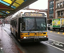
The CT1 Central Square, Cambridge–B.U. Medical Center/Boston Medical Center via M.I.T. (internally coded 701) ran between Central Square in Cambridge and the B.U. Medical Center/Boston Medical Center, mostly along Massachusetts Avenue. The majority of its route was a limited-stop version of route 1. Transfers to the 1 were possible at most of the stops. CT1 service was not substantially modified since its 1994 inception.[1] Route CT1 was merged into route 1 in September 2019 to provide more frequent service and more consistent headways.[3]
Station listing[]
| Station |
|---|
| Central Square |
| Pearl Street |
| University Park |
| M.I.T. |
| Beacon Street |
| Hynes Convention Center |
| Symphony/Westland Avenue |
| Massachusetts Avenue station |
| Washington Street |
| Harrison Avenue |
| B.U. Medical Center |
CT2[]
The CT2 Sullivan Square station–Ruggles station (internally coded 747) connects Sullivan Square in Charlestown with Ruggles in Roxbury via Kendall Square in Cambridge. The southern part of the route roughly parallels the 47.
The route was created as a Ruggles–Kendall route in September 1994. In September 2000, the route was extended to Sullivan via Union Square.[1]
Station listing[]
| Station | Transfers and notes |
|---|---|
| Sullivan Square | Orange Line, 86, 89, 90, 91, 92, 93, 95, 101, 104, 105, 109 |
| Cobble Hill | 86, 91 |
| McGrath Highway | 80, 86, 88, 90, 91, future Green Line C branch |
| Union Square | 85, 86, 87, 91, future Green Line E branch |
| Cambridge Street | 69, 85 |
| Portland Street | 85 |
| Kendall/MIT | Red Line, 64, 68, 85 |
| Massachusetts Avenue | CT1, 1 |
| Memorial Drive | — |
| Boston University | Green Line B branch, 47 |
| Park and Beacon Streets | Green Line C branch, 47 |
| Fenway Station | Green Line D branch, 47 |
| Beth Israel Hospital | CT3, 8, 19, 47, 60, 65 |
| Children's Hospital | CT3, 8, 19, 47 |
| Longwood Avenue | Green Line E branch, 39 |
| Huntington Avenue | Green Line E branch, CT3, 8, 19, 39, 47 |
| Ruggles | Orange Line, MBTA Commuter Rail, CT3, 8, 15, 19, 22, 23, 28, 43, 44, 45, 47 |
CT3[]

The CT3 Beth Israel Deaconess Hospital–Andrew Station (internally coded 708) connects the Longwood Medical Area to Andrew Square and runs entirely within the city of Boston. The route roughly parallels the 8.
The CT3 route started as Beth Israel–Andrew, but it was extended to Logan Airport in December 1998. The extension (internally coded 709) was dropped due to low ridership in March 2002. A few early morning trips were kept as the 171, running from Dudley to Logan.[1] In January 2005, some rush hour service was rerouted to serve Newmarket Square.[1]
Station listing[]
| Station | Transfers and notes |
|---|---|
| Louis Pasteur Avenue | 8, 19, 47 (part of a one-way loop) |
| Children's Hospital | CT2, 8, 19, 47 (part of a one-way loop) |
| Beth Israel Hospital | CT2, 8, 19, 47, 60, 65 (part of a one-way loop) |
| Ruggles Street/Huntington Avenue | Green Line E branch, CT2, 8, 19, 39, 47 |
| Ruggles | Orange Line, MBTA Commuter Rail, CT2, 8, 15, 19, 22, 23, 28, 43, 44, 45, 47 |
| Washington Street | Silver Line, 1, 8, 19, 47, 170 |
| Boston Medical Center | CT1, 1, 8, 47, 171 |
| B.U. Medical Center | CT1, 8, 10, 47, 171 |
| 1010 Massachusetts Avenue | 8, 10, 171 (only some trips) |
| Andrew station | Red Line, 10, 16, 17, 18, 171 |
See also[]
- List of MBTA bus routes
- List of key MBTA bus routes
References[]
| ( • help)
|
- ^ a b c d e f Belcher, Jonathan. "Changes to Transit Service in the MBTA district" (PDF). Boston Street Railway Association.
- ^ "Attachment 2: Detailed Descriptions, Plans, and Schedule of the Proposed Project by Phase". Circumferential Transit Improvements in the Urban Ring Corridor: Expanded Environmental Notification Form (ENF) (PDF). Massachusetts Bay Transportation Authority. July 2001. pp. 1–6. Archived from the original (PDF) on November 8, 2001.
- ^ "Board Approves 36 Bus Route Updates". Massachusetts Bay Transportation Authority. May 6, 2019.
External links[]
| Wikimedia Commons has media related to MBTA crosstown bus routes. |
- MBTA bus routes
- Lists of bus routes in the United States
