List of MBTA bus routes
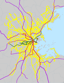
The Massachusetts Bay Transportation Authority bus division operates bus routes in the Boston, Massachusetts metropolitan area. All routes connect to MBTA subway, MBTA Commuter Rail, and/or other MBTA bus services. Many routes are descendants of the streetcar routes of the Boston Elevated Railway, or of suburban companies including the Eastern Massachusetts Street Railway, Middlesex and Boston Street Railway, and Newton and Boston Street Railway.
A number of routes have been temporarily suspended or placed on modified routings during the COVID-19 pandemic. While overall service levels were restored to pre-COVID levels in 2021, some routes remain modified or suspended.
Key[]
| Routes using Electric trolleybuses (trackless trolleys) or dual-mode buses | |
| ^ | Routes using 60-foot (18 m) articulated buses |
| N | Routes not operating during COVID-19 pandemic |
| M | Routes with modified routing during COVID-19 pandemic |
Silver Line[]


The Silver Line is a bus rapid transit system marketed as rapid transit. It is divided into two branches: Waterfront service (SL1, SL2, SL3, and the rush-hour Shuttle) that runs through the South Boston Transitway tunnel, and Washington Street service (SL4 and SL5) that runs on the surface via Washington Street. The Waterfront service costs the same as a subway fare, while the Washington Street service costs a regular bus fare.
The SL5 route was created in 2002 as a replacement for the Washington Street Elevated. The Shuttle route began operations in 2004, followed by the SL2 and SL3 (former) in 2004 and SL1 in 2005 when dual-mode buses became available. The SL4 was introduced in 2009 as a replacement for the canceled Phase III tunnel. A new SL3 route to Chelsea opened in 2018.[1]
| Route | Note | Description | MBTA link |
|---|---|---|---|
| SL1 | Logan Airport–South Station | Link | |
| SL2 | Design Center–South Station | Link | |
| SL3 | Chelsea station–South Station | Link | |
| Shuttle | Silver Line Way–South Station | ||
| SL4 | ^ | Nubian station–South Station at Essex Street | Link |
| SL5 | ^ | Nubian station–Downtown Crossing at Temple Place | Link |
Crosstown[]

The crosstown (CT) buses provide limited-stop service on two routes that connect major subway and bus transfer points. The routes were created by the MBTA in 1994.[1]
| Route | Description | MBTA link |
|---|---|---|
| CT2 | Sullivan Square station–Ruggles station | Link |
| CT3 | Beth Israel Deaconess Hospital–Andrew station | Link |
1–121[]


These routes provide almost all local service in the core of the metropolitan area; most were originally Boston Elevated Railway streetcar routes. They were originally numbered roughly clockwise from southeast to northeast, with 4 the furthest south in South Boston and 121 the furthest north (roughly) in East Boston. The BERy folded into the Metropolitan Transit Authority in 1947, and the M.T.A. in turn was reorganized as the MBTA in 1964. Despite some changes, including minor routes being merged into trunk routes, the core service network has remained roughly intact since the BERy eta. Several new routes, including the 1, 5, and 47, have been added during the M.T.A. and MBTA eras.[1]
Seven routes – the 52, 59, 62, 67, 70, 70A, and 76 – serve more distant western suburbs, such as Belmont, Lexington, and Needham; most were acquired from the Middlesex and Boston Street Railway in 1972, and subsequently renumbered using previously discontinued designations.[1]
Fifteen of these routes (those with the highest ridership in the system) are designated as key bus routes; they supplement the subway system to provide frequent service to the densest areas of the city. Key bus routes typically operate at higher frequencies than their undesignated cousins, and in March 2014 their hours of service were extended until 2:30AM on Friday and Saturday nights along with the rapid transit system.[2] In mid-2015, late-night service on some key bus routes was cut back, while other routes were dropped from late-night service. Key bus routes are designated on this list with an *.
| Route | Note | Description | MBTA link |
|---|---|---|---|
| 1 | * | Harvard Square–Nubian station | Link |
| 4 | North Station–Tide Street | Link | |
| 7 | City Point–Otis Street & Summer Street | Link | |
| 8 | Harbor Point–Kenmore station | Link | |
| 9 | City Point–Copley station | Link | |
| 10 | City Point–Copley Square | Link | |
| 11 | City Point–Bedford Street & Chauncy Street | Link | |
| 14 | Roslindale Square–Heath Street | Link | |
| 15 | * | Fields Corner station or Kane Square–Ruggles station | Link |
| 16 | Forest Hills station–Andrew station or Harbor Point | Link | |
| 17 | Fields Corner station–Andrew station | Link | |
| 18 | Ashmont station–Andrew station | Link | |
| 19 | Fields Corner station–Kenmore or Ruggles station | Link | |
| 21 | Ashmont station–Forest Hills station | Link | |
| 22 | * | Ashmont station–Ruggles station via Talbot Ave | Link |
| 23 | Ashmont station–Ruggles station via Washington Street | Link | |
| 24 | M | Wakefield Avenue & Truman Parkway–Mattapan station | Link |
| 26 | Ashmont station–Norfolk Street Loop | Link | |
| 27 | N | Mattapan station–Ashmont station | Link |
| 28 | * ^ | Mattapan station–Ruggles station | Link |
| 29 | Mattapan station–Jackson Square station | Link | |
| 30 | Mattapan station–Forest Hills station via Cummins Highway and Roslindale Square | Link | |
| 31 | Mattapan station–Forest Hills station via Morton Street | Link | |
| 32 | * | Wolcott or Cleary Square–Forest Hills station | Link |
| 33 | River Street & Milton Street–Mattapan station | Link | |
| 34 | Dedham Mall or Dedham Line–Forest Hills station | Link | |
| 34E | Walpole Center–Forest Hills station | Link | |
| 35 | Dedham Mall or Stimson Street–Forest Hills station | Link | |
| 36 | Millennium Park or VA Hospital–Forest Hills station | Link | |
| 37 | Baker Street & Vermont Street–Forest Hills station | Link | |
| 38 | Wren Street–Forest Hills station | Link | |
| 39 | * ^ | Forest Hills station–Back Bay station | Link |
| 40 | Georgetowne–Forest Hills station | Link | |
| 41 | Centre Street & Eliot Street–JFK/UMass station | Link | |
| 42 | Forest Hills station–Nubian station | Link | |
| 43 | Ruggles station–Park Street station | Link | |
| 44 | Jackson Square station–Ruggles station | Link | |
| 45 | Franklin Park–Ruggles station | Link | |
| 47 | Central Square, Cambridge–Broadway station | Link | |
| 50 | Cleary Square–Forest Hills station | Link | |
| 51 | Reservoir station–Forest Hills station | Link | |
| 52 | Dedham Mall–Watertown Yard | Link | |
| 55 | M | Jersey Street & Queensberry Street–Park Street station | Link |
| 57 | * | Watertown Yard–Kenmore station | Link |
| 57A | N | Oak Square–Kenmore station | Link |
| 59 | Needham Junction–Watertown Square | Link | |
| 60 | Chestnut Hill–Kenmore station | Link | |
| 61 | North Waltham–Waltham Center | Link | |
| 62 | M | Bedford VA Hospital–Alewife station | Link |
| 64 | Oak Square–University Park or Kendall/MIT station | Link | |
| 65 | Brighton–Kenmore station | Link | |
| 66 | * | Harvard Square–Nubian station via Allston | Link |
| 67 | Turkey Hill–Alewife station | Link | |
| 68 | Harvard Square–Kendall/MIT station | Link | |
| 69 | Harvard Square–Lechmere station | Link | |
| 70 | Market Place Drive or Waltham Center–University Park | Link | |
| 71 | * |
Watertown Square–Harvard station | Link |
| 72 | N |
Aberdeen Avenue–Harvard station | Link |
| 73 | * |
Waverley Square–Harvard Station | Link |
| 74 | Belmont Center–Harvard via Concord Avenue | Link | |
| 75 | Belmont Center–Harvard via Huron Avenue | Link | |
| 76 | M | Lincoln Lab–Alewife station | Link |
| 77 | * | Arlington Heights–Harvard station | Link |
| 78 | Arlmont Village–Harvard station | Link | |
| 79 | N | Arlington Heights–Alewife station | Link |
| 80 | Arlington Center–Lechmere station | Link | |
| 83 | Rindge Avenue–Central Square, Cambridge | Link | |
| 84 | N | Arlmont Village–Alewife station | Link |
| 85 | Spring Hill–Kendall/MIT station | Link | |
| 86 | Sullivan Square station–Reservoir station | Link | |
| 87 | Clarendon Hill or Arlington Center–Lechmere station | Link | |
| 88 | Clarendon Hill–Lechmere station | Link | |
| 89 | Clarendon Hill or Davis station–Sullivan Square station | Link | |
| 90 | Davis station–Assembly Row | Link | |
| 91 | Sullivan Square station–Central Square, Cambridge | Link | |
| 92 | Sullivan Square station–Downtown via Main Street | Link | |
| 93 | Sullivan Square station–Downtown via Bunker Hill Street | Link | |
| 94 | Medford Square–Davis station | Link | |
| 95 | West Medford or Arlington Center–Sullivan Square station | Link | |
| 96 | Medford Square–Harvard station | Link | |
| 97 | Malden Center station–Wellington station | Link | |
| 99 | Woodland Road–Wellington station | Link | |
| 100 | Elm Street–Wellington station | Link | |
| 101 | Malden Center station–Sullivan Square station via Winter Hill | Link | |
| 104 | Malden Center station–Sullivan Square station via Ferry Street | Link | |
| 105 | Malden Center station–Sullivan Square station via Newland Street Housing | Link | |
| 106 | Lebanon Loop–Wellington station | Link | |
| 108 | Linden Square–Wellington station | Link | |
| 109 | Linden Square–Sullivan Square station | Link | |
| 110 | Wonderland station–Wellington station | Link | |
| 111 | * | Woodlawn–Haymarket station | Link |
| 112 | Wellington station–Wood Island station | Link | |
| 114 | Market Basket–Maverick station | Link | |
| 116 | * | Wonderland station–Maverick station via Revere Street | Link |
| 117 | * | Wonderland station–Maverick station via Beach Street | Link |
| 119 | Northgate Shopping Center–Beachmont station | Link | |
| 120 | Orient Heights station–Jeffries Point | Link | |
| 121 | Wood Island station–Maverick station | Link |
131–137[]

Numbers from 131 to 137 operate in the Melrose area; their routings are based on routes operated as part of the former Eastern Massachusetts Street Railway, which was folded into the MBTA system in 1968. The 136 and 137 were briefly operated as far as Lowell and Lawrence, their original Eastern Mass terminals, while under MBTA control. The 132 was a Service Bus Lines route which was not operated by the MBTA until 1975.[1]
| Route | Note | Description | MBTA link |
|---|---|---|---|
| 131 | Melrose Highlands–Oak Grove or Malden Center station | Link | |
| 132 | Redstone Shopping Center–Malden Center station | Link | |
| 134 | North Woburn–Wellington station | Link | |
| 136 | M | Reading Depot–Malden Center station via Lowell Street | Link |
| 137 | M | Reading Depot–Malden Center station via North Avenue | Link |
170–171[]

170 and 171 are special low-service routes, the 170 a variant of the 70 introduced in 1968 and the 171 a replacement for early morning CT3 service when it was cut back from Logan Airport in 2002. Other numbers in the 170s were used for largely short-lived routes serving industrial areas.[1]
| Route | Note | Description | MBTA link |
|---|---|---|---|
| 170 | N | Waltham Center–Nubian station | Link |
| 171 | Logan Airport terminals–Nubian station | Link |
191–194[]
Routes from 191 to 194 are single round trips in the early morning, mainly meant for subway fare collectors but open to the public. They were introduced by the M.T.A. in 1960.[1]
| Route | Description | MBTA link |
|---|---|---|
| 191 | Mattapan station–Haymarket station | Link |
| 192 | Cleary Square–Haymarket station | Link |
| 193 | Watertown Yard–Haymarket station | Link |
| 194 | Clarendon Hill–Haymarket station | Link |
195[]
Route 195 is a special low-service route not open to the general public nor shown on MBTA maps. It connects downtown Boston with the homeless shelter at Lemuel Shattuck Hospital. Until September 2015, the route was numbered 277 to match routes 274-276 (which connected downtown Boston to the Long Island Health Campus and were suspended due to the closure of Long Island Bridge in October 2014.)[1]
| Route | Description | MBTA link |
|---|---|---|
| 195 | Lemuel Shattuck Hospital–Park Street & Tremont Street | Link |
201–202[]
The 20 belt route was created by the M.T.A. in 1962 as a combination of the 20 and 21 stub routes inherited from BERy. In 2005, the MBTA redesignated the two directions of the loop as the 201 and 202 to avoid confusion about which way each bus ran.[1]
| Route | Description | MBTA link |
|---|---|---|
| 201 | Fields Corner Loop via Neponset Ave | Link |
| 202 | Fields Corner Loop via Adams Street | Link |
210–245[]
These routes operate in the Quincy area. Routes 210-245 are based on routes originally operated by the Eastern Massachusetts Street Railway (folded into the MBTA in 1968) which mostly ran into Fields Corner station. When the Red Line's Braintree Branch opened in the 1970s, these routes were rerouted to terminate at the new rapid transit stations (principally Quincy Center).[1]


| Route | Note | Description | MBTA link |
|---|---|---|---|
| 210 | Quincy Center station–Fields Corner station | Link | |
| 211 | Quincy Center station–Squantum | Link | |
| 212 | N | Quincy Center station–North Quincy station | Link |
| 214 | N | Germantown–Quincy Center station | Link |
| 215 | Quincy Center station–Ashmont station via West Quincy | Link | |
| 216 | M | Houghs Neck–Quincy Center station | Link |
| 217 | Quincy Center station–Ashmont station via Wollaston station | Link | |
| 220 | Hingham Depot–Quincy Center station | Link | |
| 221 | N | Fort Point–Quincy Center station | Link |
| 222 | East Weymouth–Quincy Center station | Link | |
| 225 | Weymouth Landing–Quincy Center station | Link | |
| 226 | Columbian Square–Braintree station | Link | |
| 230 | Montello station–Quincy Center station | Link | |
| 236 | South Shore Plaza–Quincy Center station | Link | |
| 238 | Holbrook/Randolph station–Quincy Center station | Link | |
| 240 | Avon Square–Ashmont station | Link | |
| 245 | Quincy Center station–Mattapan station | Link |
325–326[]

These routes operate express between Medford and downtown Boston. They were introduced by the MBTA in June 1973.[1]
| Route | Note | Description | MBTA link |
|---|---|---|---|
| 325 | N | Elm Street, Medford–Haymarket station | Link |
| 326 | N | West Medford–Haymarket station | Link |
350–354[]

These routes operate in the Burlington area. They are the remains of the Eastern Massachusetts Street Railway's Lowell Division, which was inherited intact by the MBTA in 1968 and gradually declined thereafter.[1]
| Route | Note | Description | MBTA link |
|---|---|---|---|
| 350 | North Burlington–Alewife station | Link | |
| 351 | M | Bedford Woods Drive–Alewife station | Link |
| 352 | N | Burlington–State Street, Boston | Link |
| 354 | N | Woburn–State Street, Boston | Link |
411–465[]
These routes operate in the Lynn area and the North Shore. Two routes that run to Haymarket have weekend short-turn variants (labeled with a W suffix) that terminate at Wonderland. The 411 and 430 were Service Bus Lines routes that were acquired by the MBTA in 1975; the other routes are largely Eastern Massachusetts Street Railway routes acquired in 1968.[1]

| Route | Note | Description | MBTA link |
|---|---|---|---|
| 411 | Kennedy Drive or Jack Satter House–Malden Center station | Link | |
| 424 | Eastern Avenue & Essex Street–Wonderland station | Link | |
| 426 | Central Square, Lynn–Haymarket station | Link | |
| 426W | Central Square, Lynn–Wonderland station | Link | |
| 428 | Oaklandvale–Haymarket station | Link | |
| 429 | Northgate Shopping Center–Central Square, Lynn | Link | |
| 430 | Saugus Center–Malden Center station | Link | |
| 434 | N | Main Street, Peabody–Haymarket station | Link |
| 435 | M | Liberty Tree Mall–Central Square, Lynn via Peabody Square | Link |
| 436 | Liberty Tree Mall–Central Square, Lynn via Goodwin Circle | Link | |
| 439 | Nahant–Wonderland station | Link | |
| 441 | Marblehead–Wonderland station via Paradise Road | Link | |
| 442 | Marblehead–Wonderland station via Humphrey Street | Link | |
| 450 | Salem Depot–Haymarket station | Link | |
| 450W | Salem Depot–Wonderland station | Link | |
| 451 | North Beverly station–Salem Depot | Link | |
| 455 | Salem Depot–Wonderland station | Link | |
| 456 | Salem Depot–Central Square, Lynn | Link | |
| 465 | N | Danvers Square–Salem Depot | Link |
501–558[]
These routes operate express between Newton and downtown Boston via the Massachusetts Turnpike (I-90). The 500 series routes were created by the MBTA in the 1960s to take advantage of the newly constructed turnpike extension into Boston. The 550 series routes were Middlesex and Boston Street Railway routes to Newton Corner that were extended to downtown Boston in the 1960s and taken over by the MBTA in 1972.[1]

| Route | Note | Description | MBTA link |
|---|---|---|---|
| 501 | M | Brighton Center–Federal Street & Franklin Street | Link |
| 502 | N | Watertown Yard–Copley station | Link |
| 503 | N | Brighton Center–Copley Square | Link |
| 504 | M | Watertown Yard–Federal Street & Franklin Street | Link |
| 505 | Waltham Center–Federal Street & Franklin Street | Link | |
| 553 | M | Roberts–Federal Street & Franklin Street | Link |
| 554 | M | Waverley Square–Federal Street & Franklin Street | Link |
| 556 | M | Waltham Highlands–Federal Street & Franklin Street | Link |
| 558 | M | Riverside station–Federal Street & Franklin Street | Link |
Privately operated routes[]

The MBTA provides partial subsidy for some suburban routes outside its usual service area that connect with MBTA bus, subway, or commuter rail service. Routes 710-716 are radial commuter routes that accept MBTA passes on CharlieTickets only; they were taken over from various private operators (Hudson Bus Lines for the 710 and 716, Rapid Transit Inc. for the 712/713, and Nantasket Transportation for the 714).[1]
The non-numbered routes (listed here by their designator on MBTA maps) are local circulator services founded by the municipalities with partial MBTA subsidy.[1] All are operated by private companies under contract, except for the Beverly Shuttle which is operated by the Cape Ann Transportation Authority.
| Route | Note | Description | MBTA link |
|---|---|---|---|
| 710 | N | North Medford–Wellington station | Link |
| 712 | Point Shirley, Winthrop–Orient Heights station via Revere Street | Link | |
| 713 | Point Shirley, Winthrop–Orient Heights station via Winthrop Center | Link | |
| 714 | Pemberton Point, Hull–Station Street, Hingham | Link | |
| 716 | Cobbs Corner–Mattapan station | Link | |
| BED | N | Bedford Local Transit | Link |
| BEV | City of Beverly Shuttle | Link | |
| LEX | Lexington Lexpress (6 routes) | Link | |
| MIS | Mission Hill LINK | Link |
References[]
External links[]
| Wikimedia Commons has media related to MBTA bus routes. |
- MBTA bus routes
- Massachusetts transportation-related lists
- Boston-related lists
- Lists of bus routes in the United States