Macusani District
Macusani | |
|---|---|
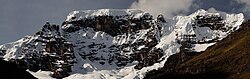 Allin Qhapaq, Macusani District | |
| Country | |
| Region | Puno |
| Province | Carabaya |
| Capital | Macusani |
| Government | |
| • Mayor | Nancy Rossel Angles |
| Area | |
| • Total | 1,029.56 km2 (397.52 sq mi) |
| Elevation | 4,315 m (14,157 ft) |
| Population (2005 census) | |
| • Total | 10,950 |
| • Density | 11/km2 (28/sq mi) |
| Time zone | UTC-5 (PET) |
| UBIGEO | 210301 |
Macusani District is one of ten districts of the Carabaya Province in Peru.[1] Its seat is Macusani.
Geography[]
The Kallawaya mountain range lies northeast of Macusani. The highest peak of the district is Allin Qhapaq at 5,805 m (19,045 ft). Other mountains are listed below:[2][3]
- Allpa Chaka
- Allpa Qhata
- Asiruni
- Champini
- Chawpi Ch'ullu
- Chikuruni
- Ch'ichi Qhapaq
- Hatun Pukara
- Huch'uy Pukara
- Inka Qayqu
- Kuntur Ikiña
- Lluxisa
- Misti Urqu
- Pichaqani
- Puka Kunka
- Pukara
- Phawchinta
- Pallqa Pata
- Pincha Pukyu
- Qillwaquta Rit'i
- Qullqi Tawqa
- Quraq Kancha
- Q'ataw Tira
- Q'illu Qaqayuq
- Q'iruni
- Sallani
- Sumpiruni
- Sura Kunka
- Taypi Tira
- Thujsaquta
- Uqi Kunka Urqu
- Wamanripa
- Wamanripani
- Wila Kunka
- Wila Muqu
- Wit'u Uma
- Yana Kancha
- Yana Salla
- Yanaqucha
Ethnic groups[]
The people in the district are mainly indigenous citizens of Quechua descent. Quechua is the language which the majority of the population (70.66%) learnt to speak in childhood, 28.51% of the residents started speaking using the Spanish language (2007 Peru Census).[4]
See also[]
- Chawpiqucha
- Parinaquta
References[]
- ^ (in Spanish) Instituto Nacional de Estadística e Informática. Banco de Información Distrital Archived 2008-04-23 at the Wayback Machine. Retrieved April 11, 2008.
- ^ escale.minedu.gob.pe/ UGEL map Crucero District 2 (Puno Region)
- ^ escale.minedu.gob.pe - UGEL maps of the Carabaya Province, Puno Region
- ^ inei.gob.pe Archived 2013-01-27 at the Wayback Machine INEI, Peru, Censos Nacionales 2007, Frequencias: Preguntas de Población: Idioma o lengua con el que aprendió hablar (in Spanish)
| |
|---|---|
| Azángaro | |
| Carabaya | |
| Chucuito | |
| El Collao |
|
| Huancané | |
| Lampa | |
| Melgar | |
| Moho | |
| Puno | |
| San Antonio de Putina | |
| San Román | |
| Sandia | |
| Yunguyo | |
This Puno Region geography article is a stub. You can help Wikipedia by . |
Coordinates: 14°04′07″S 70°25′53″W / 14.06861°S 70.43139°W

Categories:
- Districts of the Puno Region
- Districts of the Carabaya Province
- Puno Region geography stubs