Maple Heights, Ohio
Maple Heights, Ohio | |
|---|---|
 Residential neighborhood along Vine Street | |
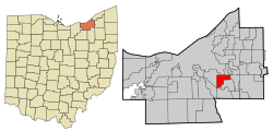 Location in Cuyahoga County and the state of Ohio. | |
| Coordinates: 41°24′44″N 81°33′35″W / 41.41222°N 81.55972°WCoordinates: 41°24′44″N 81°33′35″W / 41.41222°N 81.55972°W | |
| Country | United States |
| State | Ohio |
| County | Cuyahoga |
| Government | |
| • Type | Mayor-Council |
| • Mayor | Annette M. Blackwell |
| Area | |
| • Total | 5.17 sq mi (13.39 km2) |
| • Land | 5.17 sq mi (13.39 km2) |
| • Water | 0.00 sq mi (0.00 km2) |
| Elevation | 899 ft (274 m) |
| Population | |
| • Total | 23,138 |
| • Estimate (2019)[5] | 22,078 |
| • Density | 4,271.23/sq mi (1,649.07/km2) |
| Time zone | UTC-5 (Eastern (EST)) |
| • Summer (DST) | UTC-4 (EDT) |
| ZIP code | 44137 |
| Area code(s) | 216 |
| FIPS code | 39-47306[4] |
| GNIS feature ID | 1048945[2] |
| Website | https://www.citymapleheights.com/ |
Maple Heights is a city in Cuyahoga County, Ohio, United States. It is a suburb of Cleveland. The population was 23,138 at the 2010 census.
History[]
Maple Heights Transit[]
In 1935, the City created Maple Heights Transit to provide connections to Downtown Cleveland, crosstown service, and service for schools.[6]
Southgate USA[]
Built as one of the first large shopping centers, Southgate USA was dedicated in 1955, boasting over 80 retail stores, including JCPenney, Sears, and May Company.[7] In 2002, the GCRTA dedicated its Southgate Transit Center, serving as a connection between multiple bus lines between Downtown Cleveland, Bedford, Shaker Heights, East Cleveland, and the Summit County Line.[8][9]
Late 20th and Early 21st Centuries (1970-Present)[]
Maple Heights was declared by the Auditor of State to be in fiscal emergency in 2015, but the city has been improving its finances and budgeting since then.[10] The City was released from fiscal emergency on November 18, 2020 by the Auditor of State; in the press release, Auditor of State Keith Faber said, "I applaud the leaders of the City for making the sacrifices and hard decisions that should provide residents a fiscally responsible community."[11]
In 2020, Governor Mike DeWine announced that GOJO Industries, makers of Purell, would establish a manufacturing facility in the City in the 325,000 square foot former Blue Coral building on Lee Road South.[12] The Maple Heights facility was projected to bring 100 new jobs to the City.[12]
Geography[]
According to the United States Census Bureau, the city has a total area of 5.17 square miles (13.39 km2), all land.[13]
Demographics[]
| Historical population | |||
|---|---|---|---|
| Census | Pop. | %± | |
| 1920 | 1,732 | — | |
| 1930 | 5,950 | 243.5% | |
| 1940 | 6,728 | 13.1% | |
| 1950 | 15,586 | 131.7% | |
| 1960 | 31,667 | 103.2% | |
| 1970 | 34,093 | 7.7% | |
| 1980 | 29,465 | −13.6% | |
| 1990 | 27,089 | −8.1% | |
| 2000 | 26,156 | −3.4% | |
| 2010 | 23,138 | −11.5% | |
| 2019 (est.) | 22,078 | [5] | −4.6% |
| Sources:[4][14][15] | |||
2010 census[]
As of the census[3] of 2010, there were 23,138 people, 9,515 households, and 6,035 families living in the city. The population density was 4,475.4 inhabitants per square mile (1,728.0/km2). There were 10,894 housing units at an average density of 2,107.2 per square mile (813.6/km2). The racial makeup of the city was 68.2% African American, 28.0% White, 0.2% Native American, 1.0% Asian, 0.5% from other races, and 2.1% from two or more races. Hispanic or Latino of any race were 1.5% of the population.
There were 9,515 households, of which 32.5% had children under the age of 18 living with them, 33.0% were married couples living together, 25.0% had a female householder with no husband present, 5.4% had a male householder with no wife present, and 36.6% were non-families. 32.1% of all households were made up of individuals, and 10.4% had someone living alone who was 65 years of age or older. The average household size was 2.41 and the average family size was 3.05.
The median age in the city was 39.2 years. 25.1% of residents were under the age of 18; 8.3% were between the ages of 18 and 24; 24.5% were from 25 to 44; 28.8% were from 45 to 64; and 13.2% were 65 years of age or older. The gender makeup of the city was 46.3% male and 53.7% female.
2000 census[]
As of the census[4] of 2000, there were 26,156 people, 10,489 households, and 6,964 families living in the city. The population density was 5,039.1 people per square mile (1,945.8/km2). There were 10,935 housing units at an average density of 2,106.7 per square mile (813.5/km2). The racial makeup of the city was 51.65% White, 44.34% African American, 0.13% Native American, 1.73% Asian, 0.02% Pacific Islander, 0.47% from other races, and 1.66% from two or more races. Hispanic or Latino of any race were 1.21% of the population.
There were 10,489 households, of which 30.9% had children under the age of 18 living with them, 45.2% were married couples living together, 17.0% had a female householder with no husband present, and 33.6% were non-families. 29.9% of all households were made up of individuals, and 12.5% had someone living alone who was 65 years of age or older. The average household size was 2.47 and the average family size was 3.08.
In the city, the population was spread out, with 25.7% under the age of 18, 6.7% from 18 to 24, 30.9% from 25 to 44, 20.1% from 45 to 64, and 16.5% who were 65 years of age or older. The median age was 37 years. For every 100 females, there were 87.8 males. For every 100 females age 18and over, there were 82.7 males.
The median income for a household in the city was $40,414, and the median income for a family was $48,580. Males had a median income of $35,268versus $28,023 for females. The per capita income for the city was $18,676. About 4.7% of families and 5.9% of the population were below the poverty line, including 7.7% of those under age 18 and 6.0% of those age 65 or over.
Government[]
The City of Maple Heights is governed by an elected mayor, elected council president, and elected council. The council has seven members, with each member representing a portion of the city, known as a district. The City has had 16 mayors, including current mayor, Annette M. Blackwell; two mayors served non-consecutive terms. Mayor Blackwell was elected in 2015 as the first female and first African American mayor in the city's history.[16][17]
Education[]
Public Schools[]
The city's public school system is the Maple Heights City School District. The District is managed by a superintendent and a directly elected board. The school district has 5 schools:
- Abraham Lincoln School (PreK - Grade 1)
- John F. Kennedy School (Grade 2 - Grade 3)
- Barack Obama School (Grade 4 - Grade 5)
- Milkovich Middle School (Grade 6 - Grade 8)
- Maple Heights High School (Grade 9 - Grade 12)
Private School[]
- Castle High School - East is a public charter school on Warrensville Center Road serving Grades 9 - 12.
References[]
- ^ "2019 U.S. Gazetteer Files". United States Census Bureau. Retrieved July 28, 2020.
- ^ Jump up to: a b "US Board on Geographic Names". United States Geological Survey. 2007-10-25. Retrieved 2008-01-31.
- ^ Jump up to: a b "U.S. Census website". United States Census Bureau. Retrieved 2013-01-06.
- ^ Jump up to: a b c "U.S. Census website". United States Census Bureau. Retrieved 2008-01-31.
- ^ Jump up to: a b "Population and Housing Unit Estimates". Retrieved May 21, 2020.
- ^ "Ohio Museum of Transportation - Maple Heights Transit". www.omot.org. Retrieved 2021-06-14.
- ^ "SOUTHGATE SHOPPING CENTER". Encyclopedia of Cleveland History | Case Western Reserve University. 2018-09-24. Retrieved 2021-06-14.
- ^ RTA, Greater Cleveland (2017-07-06). "History of public transit in Cleveland". Greater Cleveland Regional Transit Authority. Retrieved 2021-06-14.
- ^ RTA, Greater Cleveland (2013-04-02). "Southgate Transit Center". Greater Cleveland Regional Transit Authority. Retrieved 2021-06-14.
- ^ "Maple Heights in fiscal emergency, says state auditor": http://www.cleveland.com/maple-heights/index.ssf/2015/02/maple_heights_in_fiscal_emerge.html
- ^ "Ohio Auditor of State Keith Faber". ohioauditor.gov. Retrieved 2021-06-14.
- ^ Jump up to: a b "GOJO announces addition of two new Northeast Ohio facilities to help meet demand for Purell". wkyc.com. Retrieved 2021-06-14.
- ^ "US Gazetteer files 2010". United States Census Bureau. Archived from the original on 2012-01-25. Retrieved 2013-01-06.
- ^ "Number of Inhabitants: Ohio" (PDF). 18th Census of the United States. U.S. Census Bureau. 1960. Retrieved 17 May 2020.
- ^ "Ohio: Population and Housing Unit Counts" (PDF). U.S. Census Bureau. Retrieved 22 November 2013.
- ^ Zicari, Peter; clevel; .com (2015-11-04). "Cuyahoga County local results: Election 2015". cleveland. Retrieved 2021-06-15.
- ^ "Maple Heights Mayor Is a First in More Ways Than One". spectrumnews1.com. Retrieved 2021-06-15.
External links[]
Municipalities and communities of Cuyahoga County, Ohio, United States | ||
|---|---|---|
| Cities |
|  |
| Villages | ||
| Townships | ||
| Footnotes | ‡This populated place also has portions in an adjacent county or counties | |
| ||
Authority control | |
|---|---|
| General | |
| National libraries | |
| Other |
|
- Cities in Ohio
- Cities in Cuyahoga County, Ohio
- Italian-American culture in Ohio