Olmsted Falls, Ohio
This article needs additional citations for verification. (May 2019) |
Olmsted Falls, Ohio | |
|---|---|
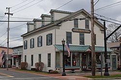 downtown | |
 Location in Cuyahoga County and the state of Ohio. | |
 Location of Ohio in the United States | |
| Coordinates: 41°22′3″N 81°54′17″W / 41.36750°N 81.90472°WCoordinates: 41°22′3″N 81°54′17″W / 41.36750°N 81.90472°W | |
| Country | United States |
| State | Ohio |
| County | Cuyahoga |
| Government | |
| • Mayor | James Patrick Graven |
| Area | |
| • Total | 4.09 sq mi (10.59 km2) |
| • Land | 4.09 sq mi (10.59 km2) |
| • Water | 0.00 sq mi (0.00 km2) |
| Elevation | 768 ft (234 m) |
| Population | |
| • Total | 9,024 |
| • Estimate (2019)[6] | 8,828 |
| • Density | 2,159.49/sq mi (833.75/km2) |
| Time zone | UTC-5 (Eastern (EST)) |
| • Summer (DST) | UTC-4 (EDT) |
| ZIP codes | 44138 |
| Area code(s) | 440 |
| FIPS code | 39-58422[4] |
| GNIS feature ID | 1072238[5] |
| Website | Official website |

Olmsted Falls is a city in Cuyahoga County, Ohio, United States, and a southwestern suburb of Cleveland. The population was 9,024 at the 2010 census. The city's main business district is located at the corners of Bagley and Columbia Roads, and contains the Grand Pacific Junction, an historic district.
Geography[]
Olmsted Falls is located at 41°22′3″N 81°54′17″W / 41.36750°N 81.90472°W (41.367626, -81.904818).[7] According to the United States Census Bureau, the city has a total area of 4.12 square miles (10.67 km2), all land.[8]

History[]
After the discovery of the New World, the land that became Olmsted Falls was originally part of the French colony of Canada (New France), which was ceded in 1763 to Great Britain and renamed Province of Quebec. In the late 18th century the land became part of the Connecticut Western Reserve in the Northwest Territory, then was purchased by the Connecticut Land Company in 1795.
In 1806, the vast tract of land comprising present-day Olmsted Falls, North Olmsted, and Olmsted Township was purchased for $30,000 by Aaron Olmsted, a wealthy sea captain. While he sold off portions of the land which eventually became known as Kingston, Aaron Olmsted named the new town as Olmsted in honor of his brother Charles, one of the original lands purchasers. The land was part of a vast tract ceded to the State of Connecticut after the Revolutionary War in payment for residents whose properties had been burned during the Revolutionary War. Some of those lands became known as the Firelands part of the western reserve lands of Connecticut.
Olmsted Falls was farmed in 1814 by James Geer who eventually built a home the following year about where the CSX Railroad now crosses State Route 252 (Columbia Road). That portion was known as Westview after Calvin and Lmul Hoadley built a mill on the Rocky River in West View.
The whole tract purchased by Aaron Olmsted and others included portions of what is now North Olmsted, North Ridgeville and Middleburg Heights.
In 1970 a group of residents sought to merge Olmsted Falls and . The suggested contract was approved by over 90% of voters in each community. The name Westview, while not on any historic maps, exists through the comic strip Funky Winkerbean drawn by West View native Tom Batiuk.
Olmsted Falls was declared a city in 1970, having attained over 5000 residents to qualify under state rules. The government is non-partisan and is governed by a charter again written by a group of citizens and presented to the electorate for a vote which was approved.
The town restricts building along the banks of the Rocky River and Plum Creek. It also is physically crossed by two major railroads. CSX a, NE/SW road and Norfolk Southern which is a mainline east–west configuration. The city's schools are administered by the Olmsted Falls City School District.
Vitamix World Headquarters is located in Olmsted Falls.
Demographics[]
| Historical population | |||
|---|---|---|---|
| Census | Pop. | %± | |
| 1870 | 383 | — | |
| 1880 | 404 | 5.5% | |
| 1890 | 342 | −15.3% | |
| 1900 | 330 | −3.5% | |
| 1910 | 394 | 19.4% | |
| 1920 | 374 | −5.1% | |
| 1930 | 673 | 79.9% | |
| 1940 | 754 | 12.0% | |
| 1950 | 1,137 | 50.8% | |
| 1960 | 2,144 | 88.6% | |
| 1970 | 2,504 | 16.8% | |
| 1980 | 5,868 | 134.3% | |
| 1990 | 6,741 | 14.9% | |
| 2000 | 7,962 | 18.1% | |
| 2010 | 9,024 | 13.3% | |
| 2020 | 8,582 | −4.9% | |
| Sources:[9][10][11][12][13][14][4] | |||
2010 census[]
As of the census[2] of 2010, there were 9,024 people, 3,684 households, and 2,431 families residing in the city. The population density was 2,190.3 inhabitants per square mile (845.7/km2). There were 3,897 housing units at an average density of 945.9 per square mile (365.2/km2). The racial makeup of the city was 94.9% White, 2.0% African American, 0.1% Native American, 1.2% Asian, 0.4% from other races, and 1.3% from two or more races. Hispanic or Latino of any race were 2.6% of the population.
There were 3,684 households, of which 32.6% had children under the age of 18 living with them, 52.5% were married couples living together, 11.0% had a female householder with no husband present, 2.6% had a male householder with no wife present, and 34.0% were non-families. 28.8% of all households were made up of individuals, and 9.4% had someone living alone who was 65 years of age or older. The average household size was 2.42 and the average family size was 3.01.
The median age in the city was 41.6 years. 24.5% of residents were under the age of 18; 6.7% were between the ages of 18 and 24; 24.1% were from 25 to 44; 31% were from 45 to 64; and 13.7% were 65 years of age or older. The gender makeup of the city was 46.7% male and 53.3% female.
2000 census[]
As of the census[4] of 2000, there were 7,962 people, 3,121 households, and 2,228 families residing in the city. The population density was 1,927.2 people per square mile (744.3/km2). There were 3,267 housing units at an average density of 790.8 per square mile (305.4/km2). The racial makeup of the city was 96.71% White, 1.31% African American, 0.99% Native American, 0.73% Asian, 0.06% Pacific Islander, 0.28% from other races, and 0.88% from two or more races. Hispanic or Latino of any race were 1.51% of the population. As of 2006, the population is estimated to be 10,000+.
There were 3,121 households, out of which 34.4% had children under the age of 18 living with them, 60.2% were married couples living together, 8.7% had a female householder with no husband present, and 28.6% were non-families. 24.8% of all households were made up of individuals, and 6.9% had someone living alone who was 65 years of age or older. The average household size was 2.54 and the average family size was 3.06.
In the city the population was spread out, with 26.6% under the age of 18, 6.2% from 18 to 24, 32.4% from 25 to 44, 24.9% from 45 to 64, and 9.9% who were 65 years of age or older. The median age was 37 years. For every 100 females, there were 92.8 males. For every 100 females age 18 and over, there were 89.2 males.
The median income for a household in the city was $57,826, and the median income for a family was $66,196. Males had a median income of $41,996 versus $35,110 for females. The per capita income for the city was $25,716. About 1.2% of families and 2.1% of the population were below the poverty line, including 1.2% of those under age 18 and 4.5% of those age 65 or over.
Education[]
The Olmsted Falls school system educates students from Olmsted Falls, parts of Columbia Station, part of Berea, and from neighboring Olmsted Township. There are five schools in the school system, Early Childhood Center, Falls-Lenox Primary School, Olmsted Falls Intermediate School, Olmsted Falls Middle School, and Olmsted Falls High School. The school colors are blue and gold, and their mascot is an English bulldog. The Olmsted Falls School District has recently been nationally recognized for teaching.
Athletics[]
In December 2000, The Bulldog football team won the Ohio High School Athletic Association Division II State Championship, defeating Piqua 21–0 at Paul Brown Tiger Stadium in Massillon.
The Lady Bulldog volleyball team won the State Championships in 2008.
The Girls Cross Country team won the State Championships in 1980, 1981, and 1987.[15]
Government[]
Executive[]
The mayor is the ceremonial head of government. He/she is full-time and presides over city council meetings, has the power to veto council actions and also acts as the Safety Director for the city.
James Patrick Graven was elected mayor on December 5, 2017 after receiving over 60% of the vote in a special runoff election.
Legislative[]
The City Council of Olmsted Falls consists of seven members elected to two year terms; Council President, Council President Pro-Tempore, Council-At-Large, Clerk of Council, representative for Ward 1, representative for Ward 2, representative for Ward 3, and representative for Ward 4. It is a "strong Council - weak Mayor" form of government, with the Mayor not holding any voting rights on Council.
The Current Olmsted Falls City Council as of January 2020 is: Paul Stibich, Council President; Lori Jones, Council Pro-Tempore; Jennifer Jansen, Council-At-Large; Jay McFadden, Council Ward 1; Cornel Munteanu, Council Ward 2; Yvonne Buchholz, Council Ward 3; Brian Chitester, Council Ward 4
Judicial[]
The Mayor's Court of Olmsted Falls is located in the City Hall building.
| show Places adjacent to Olmsted Falls, Ohio |
|---|
References[]
- ^ "2019 U.S. Gazetteer Files". United States Census Bureau. Retrieved July 28, 2020.
- ^ Jump up to: a b "U.S. Census website". United States Census Bureau. Retrieved 2013-01-06.
- ^ "US Board on Geographic Names". United States Geological Survey. 2007-10-25. Retrieved 2008-01-31.
- ^ Jump up to: a b c "U.S. Census website". United States Census Bureau. Retrieved 2008-01-31.
- ^ "Olmsted Falls". Geographic Names Information System. United States Geological Survey.
- ^ Cite error: The named reference
USCensusEst2019was invoked but never defined (see the help page). - ^ "US Gazetteer files: 2010, 2000, and 1990". United States Census Bureau. 2011-02-12. Retrieved 2011-04-23.
- ^ "US Gazetteer files 2010". United States Census Bureau. Archived from the original on 2012-07-14. Retrieved 2013-01-06.
- ^ "Population of Civil Divisions Less than Counties" (PDF). Statistics of the Population of the United States at the Ninth Census. U.S. Census Bureau. 1870. Retrieved 17 May 2020.
- ^ "Population of Civil Divisions Less than Counties" (PDF). Statistics of the Population of the United States at the Tenth Census. U.S. Census Bureau. 1880. Retrieved 28 November 2013.
- ^ "Population: Ohio" (PDF). 1910 U.S. Census. U.S. Census Bureau. Retrieved 28 November 2013.
- ^ "Population: Ohio" (PDF). 1930 US Census. U.S. Census Bureau. Retrieved 28 November 2013.
- ^ "Number of Inhabitants: Ohio" (PDF). 18th Census of the United States. U.S. Census Bureau. 1960. Retrieved 17 May 2020.
- ^ "Ohio: Population and Housing Unit Counts" (PDF). U.S. Census Bureau. Retrieved 22 November 2013.
- ^ "OHIO HIGH SCHOOL ATHLETIC ASSOCIATION". www.ohsaa.org. Retrieved 2015-09-23.
External links[]
- City of Olmsted Falls Website
- Olmsted Falls City Schools
- Grand Pacific Junction Historic and Shopping District
| show Municipalities and communities of Cuyahoga County, Ohio, United States |
|---|

| show Authority control |
|---|
- Cities in Ohio
- Cities in Cuyahoga County, Ohio
- Cleveland metropolitan area