Mara Autonomous District Council
Mara Autonomous District Council | |
|---|---|
 | |
| Type | |
| Type | Autonomous District Council |
| Leadership | |
Chief Executive Member | N Zakhai |
| Structure | |
| Seats | 28 Councillors |
Political groups | Government (22)
Opposition (6)
|
| Elections | |
Voting system | 25 plurality voting |
Voting system | 3 nominated |
Last election | 2017 |
| Meeting place | |
| Siaha | |
| Website | |
| https://madc.mizoram.gov.in/ | |
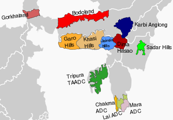
Mara Autonomous District Council (MADC) is one of the three Autonomous District Councils within Mizoram state of India. It covers Siaha subdivision and Tipa subdivision of Siaha district. Primarily, an autonomous administrative government meant for the Mara people living in the state. It is situated in the southern tip of Mizoram state bordering Myanmar. Its autonomy was established and carved out from the erstwhile Pawi-Lakher Regional Council on 29 May 1971 and separated the next year as Lakher Autonomous District Council, and renamed it to current name in 1988.[1] It covers 1445 square kilometres.[1]
The government has jurisdiction over land administration, administration of justice, and limited legislative powers, and a few other local powers.[2] In 2009 the council was led by an independent member of the District Council, Shri. N. Viakhu who formed coalition government with Maraland Democratic Front and Indian National Congress in 2005 election.
In December 2005, Independent Member of the District Council, Shri. N. Viakhu formally joined Mizo National Front (MNF) to lead a new MADC government formed by MNF with a simple majority. He was severely criticized for his nomination of four MNF workers to MDC nominated seats despite being the CEM of the Cong-MNF coalition government. The nomination allows MNF to enjoy a simple majority (15 - 11); otherwise Cong-MDF combine and MNF were tied at 11 elected members each.
The latest election of MADC had been held in 2017, with an Indian National Congress gained a majority. A new government by Congress was formed thereafter. The current Chief Executive Member (CEM) is Shri N.Zakhai. The Chairman is Shri H.Sahlo.
History[]
In 1954 the Central and Assam governments established a regional council, the Pawi Lakher Regional Council (PLRC), for the Lakhers (aka Mara) and the Pawis (aka Lai), in which a large number of Chakmas also resided. However, the PLRC could not function properly right from its inception as there was no common communication language among the three tribal communities to understand each other. The first meeting was held without understanding each other’s language where Mizo was used as official language but Chakmas and Maras could hardly understand anything. Consequently, in 1958 the Maras boycotted PLRC meetings. In 1972, to resolve the issue the PLRC was divided into three regional councils and upgraded to 3 district councils for Maras, Lais and Chakmas.[3]
Departments[]
Mara Autonomous District Council looks after many departments in her area including fisheries, schools (up to Middle school) and education, judiciary, land and revenue, forestry, Public Health Engineering (PHE), etc.
Tourist spots[]
Tourist spots within MADC include
- Siaha - the district headquarters,
- Mt. Mawma, the highest mountain in MADC area and the 3rd highest mountain(6725 ft) in Mizoram state. About 3 km from Chakhei town, 76 km approx. from Siaha.
- Pala Lake, the biggest lake in the state,
- , the biggest river in Mizoram, that serves as border between MADC and Lai Autonomous District Council. Kaladan river fish are famous for their taste.
- Phura - the only town on plain. The barn of Maraland.
- Tokalo (Pala) Wildlife Sanctuary, some 80 km Southwest of Siaha.
- Tipa or Tuipang - the second largest and vibrant town in the central part of MADC or Maraland.
- Kolodyne Bridge - The longest bridge in Mizoram.
- Zyhno-the third largest town and the place where the Mara village is located.
See also[]
- Chakma Autonomous District Council
- Lai Autonomous District Council
- North Eastern Council
- Hill tribes of Northeast India
References[]
- ^ a b Zohra, K. (17 June 2003) "Mara History, Maraland Location, Physical features" Archived 2010-12-31 at the Wayback Machine Maraland Net
- ^ Roy, Devasish, Raja (2005) Traditional Customary Laws and Indigenous Peoples in Asia Minority Rights Group International, London, p. 15. ISBN 1-904584-27-6
- ^ "Chakma Autonomous District Council" Agriculture Department, Mizoram State Annual Plan 2003-2004 Archived 21 July 2011 at the Wayback Machine page 284, last accessed 23 December 2010
External links[]
- Mara Autonomous District Council
- An article about formation of new government at Mara Autonomous District Council
- Maraland.NET: An internet home of Mara people
22°29′N 92°58′E / 22.48°N 92.97°ECoordinates: 22°29′N 92°58′E / 22.48°N 92.97°E
 WikiMiniAtlas
| 6th Schedule areas (Constitution of India) |
| ||||||||
|---|---|---|---|---|---|---|---|---|---|
| Non-6th Schedule areas (State legislation) |
| ||||||||
| Proposed states |
|  |
|---|---|---|
| Proposed union territories |
| |
Current states and union territories of India | ||
| Mizoram |
|  Yimchunger Naga woman |
|---|---|---|
| Nagaland |
| |
| Meghalaya |
| |
| Arunachal Pradesh |
| |
| Manipur | ||
| Tripura | ||
| Assam |
| |
| Sikkim | ||
| Kuki tribes including: |
| |
| Naga tribes including: | ||
See also List of Scheduled Tribes in India | ||
Capital: Aizawl | |
| State symbols |
|
| Government |
|
| Topics | |
| Districts | |
| Urban Areas | |
| Infrastructure |
|
| Education |
|
| Tourism | |
| Protected areas | |
| Mizo Culture |
|
- Government of Mizoram
- Saiha
- Autonomous district councils of India
- 1971 establishments in Assam