Proposed states and union territories of India
This article uses bare URLs, which may be threatened by link rot. (September 2021) |


The constitutional power to create new states and union territories in India is solely reserved to the Parliament of India. Parliament can do so by announcing new states/union territories, separating territory from an existing state or merging two or more states/union territories or parts of them.[1] In addition to the existing twenty eight states and eight union territories,[2] some new states and union territories of India have at various times been proposed to be established.[3]
Indian constitution under (Part I: The Union and its territory) allows certain provisions for creation of new states and union territories under Indian union-: 1) Name and territory of the Union. 2) Admission or establishment of new States. 3) Formation of new States and alteration of areas, boundaries or names of existing States. 4) Laws made under articles 2 and 3 to provide for the amendment of the First and the Fourth Schedules and supplemental, incidental and consequential matters.[4]
History[]
Before independence, India was divided into British-administered provinces and nominally autonomous princely states, which were governed by the British administration. After the partition of India, some of these administrative divisions became part of the Dominion of Pakistan, whilst the remaining states and provinces formed the Dominion of India. The colonial system of administration continued until 1956 when the States Reorganisation Act abolished the provinces and princely states in favour of new states which were based on language and ethnicity.
Several new states and union territories have been created out of the existing states since 1956. The Bombay Reorganisation Act split the Bombay State into the present-day states of Gujarat and Maharashtra on 1 May 1960 on a linguistic basis.[5] The state of Nagaland was created on 1 December 1963.[6] The Punjab Reorganisation Act, 1966 carved out a new Hindi-speaking state of Haryana from the southern districts of Punjab state,[7] transferred the northern districts to Himachal Pradesh and designated a union territory around Chandigarh, the shared capital of Punjab and Haryana.[8]
Statehood was conferred upon Himachal Pradesh on 25 January 1971,[9] and upon Manipur, Meghalaya and Tripura on 21 January 1972.[10] The Kingdom of Sikkim joined the Indian Union as a state on 26 April 1975.[11] In 1987, Arunachal Pradesh and Mizoram became states on 20 February, followed by Goa on 30 May of the same year. Goa's northern exclaves of Daman and Diu became a separate union territory.[12]
Three new states were created in November 2000: Chhattisgarh (1 November) was created out of eastern Madhya Pradesh;[13] Uttaranchal (9 November), which was later renamed Uttarakhand,[14] was created out of the mountainous districts of northwest Uttar Pradesh;[15] and Jharkhand (15 November) was created out of the southern districts of Bihar.[16]
On 2 June 2014, Telangana was separated from Andhra Pradesh as the 29th state of the union.[17]
On 31 October 2019, Jammu and Kashmir state was split into two new Union Territories: Jammu and Kashmir and Ladakh.[18]
On 26 January 2020, the Union Territory of Daman and Diu and the Union Territory of Dadra and Nagar Haveli were merged into one Union Territory: the Union Territory of Dadra and Nagar Haveli and Daman and Diu.[19] India may have 50 states in near future if all statehood demands are conceded.[20]
Andhra Pradesh[]
Rayalaseema[]

Rayalaseema region of Andhra Pradesh comprises four districts namely, Kurnool, Kadapa, Anantapur and Chittoor. On various occasions, there have been demand for the statehood of Rayalaseema.[21] Grievances include lack of development, not establishing Kurnool City as the capital and non-implementation of Sribagh Pact.[22] Rayalaseema Parirakshana Samithi was formed by Byreddy Rajasekhar Reddy in 2013 to champion the cause for a separate Rayalaseema state. There have also been demands to include two coastal districts of Prakasam and Nellore district to form Greater Rayalaseema.[23]
Assam[]
Bodoland[]
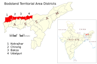
The agitation for the creation of a separate Bodoland state resulted in an agreement between the Indian Government, the Assam state government and the Bodo Liberation Tigers Force. According to the agreement made on 10 February 2003, the Bodoland Territorial Council, an entity subordinate to the government of Assam, was created to govern four districts covering 3082 Bodo Kachari-majority villages in Assam.[24][25] Elections to the council were held on 13 May 2003, and Hagrama Mohilary was sworn in as the chief of the 46-member council on 4 June.[26]
Karbi Anglong[]

Karbi Anglong is one of the 35 districts of Assam. Karbi Anglong was previously known as Mikir Hills. It was part of the Excluded Areas and Partially Excluded Areas (the present North East India) in British India. The British Indian government had never included this area under their government's jurisdiction. Thereby, no government development work or activity were done, nor any tax levied from the hills including Karbi Anglong. The first memorandum for a Karbi homeland was presented to Governor Reid on 28 October 1940 by Semsonsing Ingti and Khorsing Terang at Mohongdijua.[27] The Karbi leaders were then, a part of the All Party Hill Leaders' Conference (APHLC) which was formed on 6 July 1960.[28] The movement again gained momentum when the Karbi Anglong District Council passed a resolution demanding a Separate State in 1981. Then again from 1986 through the leadership of Autonomous State Demand Committee (ASDC), demanded Autonomous statehood of Karbi Anglong and Dima Hasao under Article 244(A). In 2002, the Karbi Anglong Autonomous Council passed another resolution to press for the demand of statehood. Several other memoranda were submitted at different times by several organisations. The demand for a separate state turned violent on 31 July 2013 when student demonstrators set government buildings on fire. Following the incident, the elected leaders of Karbi Anglong jointly submitted a memorandum to the Prime Minister of India demanding a separate State.
Dimaraji[]

The Dimasa people of northeast India have been demanding a separate state called Dimaraji or "Dimaland" for several decades. It would comprise the Dimasa-Kachari inhabited areas, namely Dima Hasao district, Cachar district, parts of Barak Valley, Nagaon district, Hojai district and Karbi Anglong district in Assam together with part of Dimapur district in Nagaland.
Barak state[]

The Barak Valley comprising the present districts of Cachar, Karimganj and Hailakandi is contiguous to Sylhet (Bengal plains), where the Bengali Hindus, according to historian J.B. Bhattacharjee, had settled well before the colonial period, influencing the culture of Dimasa Kacaharis.[29] Bhattacharjee describes that the Dimasa kings spoke Bengali and the inscriptions and coins written were in Bengali script.[29] Migrations to Cachar increased after the British annexation of the region.[29] The native Bengali people of Assam demanded separate state for themselves within the Bengali majority areas of Assam particularly Bengali majority Barak valley comprising three districts: Cachar, Hailakandi, Karimganj along with Dima Hasao and Lumding was also demanded to meet the criteria for creating a separate state for themselves by carving out from Assam's Assamese majority Brahmaputra valley post NRC.[30][31][32][33] Silchar is the proposed capital of Barak state.[34] Barak valley is the most neglected part of Assam in terms of its infrastructure development, tourism sector, educational institutions, hospitals, IT industries, G.D.P, H.D.I etc. which is still lagging behind in comparison to the Assam's mainland Brahmaputra valley which have access to all of those facilities mentioned above.[35][36][37][38][39][40] In fact, the southern Assam have a overall indigenous Bengali majority population particularly Lumding have (95%) Bengali majority,[41] Barak Valley region have a overwhelming Bengali majority of about (80.3%), while Dima Hasao have approximately (30.2%) significant Bengali plurality on certain pockets specially in the urban areas of the district.[42]
Bihar[]
Bhojpur[]

There have been demands for a Bhojpur state, comprising the Bhojpuri speaking districts of western Bihar and eastern Uttar Pradesh.[43][44][45]
Mithila[]

Mithila is a proposed state which would cover the Maithili speaking regions of Bihar. There are 5 Maithili-speaking districts in Bihar: Darbhanga, Madhepura, Madhubani, Saharsa,Supaul,There are also demands for the inclusion of six other angika speaking districts of Jharkhand: Deoghar, Dumka, Godda, Jamtara, Pakaur, and Sahebganj.but it will not possible because angika is totally different language.. capiturl=https://books.google.com/books?id=nKqF_AgDd4gC&q=mithila+india+state&pg=PA148 | title=Small States Syndrome in India | access-date=16 February 2017 | pages=146| isbn=9788170226918 | last1=Kumāra | first1=Braja Bihārī | year=1998 }}</ref>
Delhi[]
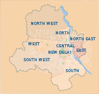
The political administration of Delhi more closely resembles that of a state than a union territory, with its own legislature, high court and an executive council of ministers headed by a Chief Minister. New Delhi is jointly administered by the Union government and the local government of Delhi. The previous National Democratic Alliance government introduced a bill in Parliament in 2003, to grant full statehood to Delhi, but the legislation was not passed. Till today Formation of a state from territories of UT of Delhi and parts of surrounding states by the name Indraprasta is not possible.[46]
Gujarat[]
Bhilistan[]
The establishment of Bhilistan has been a demand for over 30 years.[47] The 1999 book Untouchable Dalits in Modern India by S. M. Michael reported the demand for Bhilistan.[48] In 2012, The Times of India reported that the Bhilistan movement has been gaining ground in the tribal regions of Bharuch.[49] The Daily News and Analysis reported in 2013 that the formation of Telangana state has reignited hopes for the demand of statehood to this region, comprising the tribal dominated parts of Gujarat and neighbouring states Madhya Pradesh and Maharashtra.[47]
Kutch[]

Kutch State or Cutch State, covering Kutch district of Gujarat, Great Rann of Kutch and Little Rann of Kutch, is an aspirant, both as an independent state and as a combined Saurashtra. Saurashtra State (alias Kathiawar, uniting very many former princely states) and former Salute state Kutch State existed as separate states from 1947 to 1956.[50][51] They were Part-B and Part-C states of India respectively. They were later merged with Bombay state following the States Reorganisation Act.[52] They became part of Gujarat after the bifurcation of Bombay state on 1 May 1960 following the Mahagujarat Movement. Some people demand a return of statehood to Saurashtra and Kutch citing slow development of the regions.[53] Apart from these two separate state-hood demands there is as demand for separate Bhilistan state.[50][47][54]
At the time of the integration of the princely state of Kutch with India in 1947, the accession was done on the condition that Kutch would retain the status of a separate state. It enjoyed this status till 1960, when a separate state of Gujarat was carved out of Maharashtra and Kutch was merged with it. The main reason behind a separate state is cultural and geographical distance from Gandhinagar. In 1960, Kutch was promised an autonomous development board under Article 371(2) of the Constitution, which never came into existence due to lack of political will. Water from river Narmada does not reach the farms of this region.[55]
Saurashtra[]

The Saurashtra state movement for separate Saurashtra state was initiated in 1972 by advocate Ratilal Tanna, who was a close aide of former Prime Minister Morarji Desai. As per the Saurashtra Sankalan Samiti, more than 300 organisations across the Saurashtra region support the demand of the separate State. The Samiti also claims that compared to other parts of Gujarat, Saurashtra is underdeveloped. Lack of better water supply to the region, lack of job opportunities and subsequent youth migration have been cited as major reasons for the demand of statehood.[50][47][56] Saurashtra is linguistically different from the rest of the state with its Saurashtra dialect being in use.[57]
Jammu and Kashmir[]

Jammu state and Kashmir state[]
Ethnic Kashmiri leaders, including writer and opinion leader Ghulam Nabi Khayal, have called for the division of Jammu and Kashmir into separate states as a possible solution to the Kashmir conflict.[citation needed] The proposed state of Kashmir comprises the Kashmir Division and the proposed state of Jammu comprises the Jammu Division. The Jammu region is demographically very different from the Kashmir valley. It is primarily inhabited by Dogras, Gujjars and Sikhs who speak the Dogri, Gojri, Punjabi languages.
In late 2020, IkkJutt Jammu was launched as a party and demanded Jammu Division be separated and given statehood. The party also supports splitting Kashmir Division into two union territories, with one for Kashmiri Hindus.[58]
Panun Kashmir[]
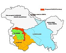
Panun Kashmir is a superficial proposed union territory in the Kashmir Valley which is advocated by the Kashmiri Pandit Network as a homeland for Kashmiri Hindus who have fled the Kashmir valley as a result of ongoing violence and hope to return.[59]
Karnataka[]
Karu Nadu[]

The proposed state of North Karnataka includes the districts of Belgaum, Bijapur, Bagalkot, Bidar, Bellary, Gulbarga, Yadgir, Raichur, Gadag, Dharwad, Haveri, Koppal and Vijayanagar.
Major cities and towns in the region are Bagalkot, Belgaum, Bellary, Bidar, Bijapur, Dharwad, Gadag, Gangavati, Gokak, Gulbarga, Haveri, Hospet, Ilkal, Koppal, Raichur, Hubli, Ranebennur, Yadgir. There is a notable difference from the regions of Old Mysore, Coastal Karnataka and Central Karnataka in terms of language, cuisine and culture. The region is well known for its contributions to the literature, arts, architecture, economy and politics of Karnataka.
Tulu Nadu[]

Tulu Nadu is a border region between the states of Karnataka and Kerala in southern India. The demand for a separate state is based on a distinct culture and language (Tulu, which does not have official status), and neglect of the region by the two state governments.[60][61] To counter these demands and accusations, the Karnataka and Kerala state governments have created the to preserve and promote Tuluva culture.[62] The proposed state would comprise three existing districts; Dakshina Kannada and Udupi from Karnataka, and Kasaragod district from Kerala.
Kodagu[]
Kodagu is a district of Karnataka that is predominantly inhabited by Kodava people. Codava National Council (CNC) is demanding to make it an "autonomous region."[63]
Madhya Pradesh[]
Madhya Pradesh is the second largest by area and holds nearly 9.37% of land area of country. It also has approximately 10% of India's population. The regions of Madhya Pradesh are ethno-linguistically very different and find no connect to each other. Hence there has been a constant demand to divide the state into smaller states with homogenous population
Baghelkhand, Bundelkhand and Vindhya Pradesh[]

Vindhya Pradesh is a newly proposed state of India. It occupied an area of 23,603 sq. miles.[64] It was created in 1948, shortly after the independence of India, from the territories of the princely states in the eastern portion of the former Central India Agency. It was named for the Vindhya Range, which runs through the center of the province. The capital of the state was Rewa. It lay between Uttar Pradesh to the north and Madhya Pradesh to the south, and the enclave of Datia, which lay a short distance to the west, was surrounded by the state of Madhya Bharat.
Vindhya Pradesh was merged into Madhya Pradesh in 1956, following the States Reorganisation Act.[52] In 2000, Sriniwas Tiwari, ex-speaker of the Madhya Pradesh assembly, called for nine districts to be separated from Madhya Pradesh to create a new state of Vindhya Pradesh, although this was rejected by the Chief Minister of Madhya Pradesh.[65] Separate Bundelkhand and Baghelkhand states instead of a single Vindhya Pradesh is advocated as well to accommodate the districts claimed by these regions from neighboring state of Uttar Pradesh.[66][67] Demand of Bundelkhand state is gaining popularity nowadays, Ex Chief Minister of MP, Member of Parliament, BJP Veteran leader Uma Bharti has assured people of the region to raise voice for separate Bundelkhand state, apart from her Ex Chief Minister of UP Mayawati has also expressed her support for Bundelkhand state, Bundelkhand state would comprise more than 16 districts, prominent Districts and areas are Jhansi, Lalitpur, Urai, Jalon, Banda, Chitrakoot, Hamirpur, Mauranipur, Mahoba of UP State and Sagar, Damoh, Panna, Chhatarpur, Tikamgarh, Shivpuri, Datia and some part of Gwalior in MP State, this region has minerals like Gold and Diamond. Recently Voice for Bundelkhand state is raised by Bundelkhand Mukti Morcha headed by Raja Bundela of Lalitpur, who is continuously working to get it organised but still there is no serious action have been taken by any government of MP and UP.
Mahakoshal and Gondwana[]
Mahakoshal is a region which lies in the upper or eastern reaches of the Narmada River valley in the Indian state of Madhya Pradesh. Cities and districts of the region include Jabalpur, Chhindwara, Katni, Narsinghpur, Mandla, Dindori, and Seoni. The largest city and a possible capital is Jabalpur. Organisations such as Mahakaushal Mukti Morcha and Bharatiya Janashakti have demanded separate statehood for the region.[68][69]
It is alleged that though the Mahakoshal region is rich in minerals, forests, water and land resources, related industries were set up in nearby states.[69] Also, the region has a distinct cultural identity owing to Jabalpur city, known as the Sanskardhani (cultural capital) of the State, one of the oldest towns of central India. Culturally and socially, the Mahakoshal region differs greatly from the neighbouring Vindhya Pradesh. One of the key reasons for this is said to be that large parts of Mahakoshal were under direct British rule from the nineteenth century onwards, turning it into a relatively progressive, modern and liberal area and infusing democratic values into its body politic. Casteism and feudalism are said to be not as deeply rooted in this region as they are in Vindhya Pradesh.[70]
A parallel demand for a state of Gondwana from the same Mahakoshal region of Madhya Pradesh has arisen owing to the fact that vast areas of Mahakoshal were ruled by Gond kings and even today, Mandla, Chinndwara, Dindori, Seoni and Balaghat have a predominantly Gond tribal population. Tribals constitute 64 per cent of the total population of Dindori district. For Mandla, the corresponding figure is 57 per cent. The Gondwana Gantantra party (GGP) was established in 1991, with the objective to struggle for the creation of a separate Gondwana State comprising regions that were ruled by Gonds. The Gondwana Gantantra party (GGP) has since divided into numerous factions such as Rashtriya Gondwana party and Gondwana Mukti Dal.[70]
Malwa[]
There have been demands for a separate Malwa state with the probable capital at Indore. The region includes the Madhya Pradesh districts of Agar, Dewas, Dhar, Indore, Jhabua, Mandsaur, Neemuch, Rajgarh, Ratlam, Shajapur, Ujjain, and parts of Guna district and Sehore, and the Rajasthan districts of Jhalawar and parts of Banswara and Pratapgarh.
The main language of Malwa is Malvi, although Hindi is widely spoken in the cities. This Indo-European language is subclassified as Indic. The language is sometimes referred to as Malavi or Ujjaini. Malvi is part of the Rajasthani branch of languages; Nimadi is spoken in the Nimar region of Madhya Pradesh and in Rajasthan. The dialects of Malvi are, in alphabetical order, Bachadi, Bhoyari, Dholewari, Hoshangabadi, Jamral, Katiyai, Malvi Proper, Patvi, Rangari, Rangri and Sondwari. A survey in 2001 found only four dialects: Ujjaini (in the districts of Ujjain, Indore, Dewas and Sehore), Rajawari (Ratlam, Mandsaur and Neemuch), Umadwari (Rajgarh) and Sondhwari (Jhalawar, in Rajasthan). About 55% of the population of Malwa can converse in and about 40% of the population is literate in Hindi, the official language of the Madhya Pradesh state.[71]
Rewakhand[]
An initiative has been started by MP High Court Bar council with a demand of a new state of "Rewakhand" from the eastern half of the state combining all the regions of Vindhya Pradesh, Bundelkhand, Baghelkhand and Mahakoshal.
Maharashtra[]
Vidarbha[]
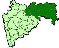
Vidarbha is a region that comprises the Amravati and Nagpur divisions of eastern Maharashtra. The State Reorganisation Act of 1956 placed Vidarbha in Bombay State. Shortly after this, the States Reorganisation Commission recommended the creation of Vidarbha state with Nagpur as the capital, but instead it was included in Maharashtra state, which was formed on 1 May 1960. Support for a separate state of Vidarbha had been expressed by Loknayak Bapuji Aney and Brajlal Biyani. The demand for the creation of a separate state are based on allegations of neglect by the Maharashtra state government. Jambuwantrao Dhote led a popular struggle for Vidarbha statehood in the 1970s. Two politicians, N. K. P. Salve and Vasant Sathe, have led attempts to bring about a state of Vidarbha in recent times.
The BJP supported the Vidarbha statehood demand and it won 44 out of the 62 seats in Vidarbha region in the 2014 Maharashtra Legislative assembly election and got majority in the Maharashtra Legislative assembly. However, BJP didn't create a separate state after winning the election. In the following 2019 legislative assembly election, BJP was defeated badly and it won only 29 seats. [72]
Marathwada[]
There have been demands for an independent Marathwada.[73]
Meghalaya[]

Garoland[]
Garo Hills Autonomous District Council (GHADC) is seated at Tura and covers East Garo Hills district, West Garo Hills district, South Garo Hills District, North Garo Hills District and South West Garo Hills District is one of the three Autonomous District Councils within Meghalaya state, and one of fourteen autonomous regions of India.
The Garo National Council is a political party in Meghalaya in northeastern India. Founded by Clifford R. Marak, the party fights for the creation a new state Garoland of a Garo-majority state, to be carved out of three districts of Meghalaya, West Garo Hills, East Garo Hills, and South Garo Hills. The Garoland demand of GNC is different from that of the separatist guerrilla Achik National Volunteer Council. ANVC also demands that parts of Assam ought to be part of Garoland.
GNC won one seat in the Garo Hills Autonomous District Council elections in 2002.
In the state assembly elections in Meghalaya of 2003, GNC had put up seven candidates, whom together received 8,483 votes. Clifford Marak, the only GNC MLA in the state legislature, died on 1 March 2015 of liver and kidney disease.
Mizoram[]
Chakmaland[]
The Chakma people has been demanding to change the status of the Chakma Autonomous District Council into a Union territory under the name Chakmaland.[74][75]
Chakmaland is a proposed union territory for the predominantly Buddhist Chakma people in Mizoram which is their own homeland (Western Mizoram) that came under Indian territory from Chittagong Hill Track (CHT Bangladesh) in 1947 during partition. Chakmas have been demanding to convert the existing Chakma Autonomous District Council and areas of Tlabung in Mizoram into a Union territory. The Chakma people have faced discrimination by the Mizo people, who are predominantly Christian.[76]
Tripura[]
Tipraland[]

Tipraland is the name of a proposed state in India. The formation of "Tipraland", a state within the TTAADC, under articles 2 and 3 of the Indian Constitution is demanded by the Indigenous People's Front of Tripura (IPFT) as one of their political agenda. Another registered regional political party Tipraland State Party (TSP) also demanding the same demand of Tipraland. The Kingdom of Tripura is a former kingdom which was ruled by 184 Tripuri/Tipra kings. The first king of the Manikya Dynasty of Tripura was Maha Manikya, who ruled the kingdom in the early 15th century.[77] The earlier kings are partly mythological and partly legendary or semi-legendary. The second last king was Maharaja Bir Bikram Kishore Debbarman Manikya Bahadur. After his death in 1947, Tipra kingdom joined India as a C-Model State on 15 October 1949 under the name Tripura, and later achieved statehood on 21 January 1972.[78]
Historically, the Kirati Tripuri converted Hindu rulers of Tripura's Manikya dynasty had always encouraged the immigration of and settlement of non-tribals, especially Bengalis to Tripura. Rajmala authenticates the fact that Ratna Manikya (1464-1468) was the first to 'settle 4000 Bengalis in four places' in Tripura. During Noakhali riots in 1946 many Bengali Hindu survivors referred to as East Bengali Refugees were sheltered in temporary relief camps in Comilla, Chandpur, Agartala the present capital of Tripura and other places. A large migration of Bengali Hindus and Muslims took place in Assam, Meghalaya, Tripura and other places during Bangladesh Liberation War on 1971.
The indigenous Tipra people demanded an autonomous district, which they finally achieved on 23 March 1979 which is known as Tripura Tribal Areas Autonomous District Council (TTAADC). The politically important TTAADC constitutes two-thirds of Tripura's 10,491 km2 area, which has 12,16,465 (mostly tribals) of the state's 37 lakh population residing in it. Tribal Welfare Department (Government of Tripura) strictly monitoring the implementation of the Tripura Scheduled Castes and Scheduled Tribes Reservation Act, 1991 (As amended up to February, 2006) for departmental promotion / direct recruitment in all Government Departments / PSUs and local bodies. For admission in schools / colleges, allotment of seats in Medical / Engineering and other Technical and General Courses, 31% reservation for ST is strictly followed. Schedule Tribes in Tripura are exempted from income tax.
Uttar Pradesh[]


At least four states have been proposed to be carved out of Uttar Pradesh.[79]
Awadh Pradesh[]
The population of proposed Awadh state, consisting of Awadhi speaking districts of central Uttar Pradesh, would be approximately 50 million people with an area of approximately 75,000 km2 and Lucknow as the capital.
Braj Pradesh and Harit Pradesh/Pashchim Pradesh[]
Harit Pradesh is a proposed state, which would comprise 22 districts of Western Uttar Pradesh, currently forming six divisions – Agra, Aligarh, Bareilly, Meerut, Moradabad, Saharanpur and some parts of the Kanpur Division, (Farrukhabad, Etawah and Auraiya districts). The most prominent advocate for the creation of the new state is Ajit Singh, the leader of the Rashtriya Lok Dal party. Mayawati also supported the formation of Harit Pradesh in December 2009.
There is another demand within the same region – Braj Pradesh, consisting of Agra division, Aligarh division and some districts of the Kanpur division (Farrukhabad, Etawah and Auraiya) from Uttar Pradesh, and the districts of Bharatpur, Dholpur and Gwalior from Rajasthan and Madhya Pradesh. The proposed capital would be in Agra.[80][81] So far, Braj has remained as a historical and cultural region, rather than a political entity. The language of Braj is Braj Bhasha.
Bundelkhand[]

Bundelkhand comprises parts of Uttar Pradesh and Madhya Pradesh. In 2011, the Bahujan Samaj Party government under Chief Minister Mayawati proposed the creation of Bundelkhand from seven districts of Uttar Pradesh, with Allahabad as the capital. Organisations such as Bundelkhand Mukti Morcha (BMM) also demanded for its formulation, along with inclusion of six other districts from Madhya Pradesh as well.[82] Uma Bharati of the Bharatiya Janata Party promised a separate state of Bundelkhand within three years if her party was voted to power, during campaigning for the 2014 Loksabha Elections at Jhansi.[83] A similar promise was made by Congress leader Pradeep Jain Aditya during these elections.[84]
Since the early 1960s there has been a movement for establishing a Bundelkhand state for promoting development of the region. Bundelkhand is geographically the central part of India covering part of Madhya Pradesh and part of Uttar Pradesh. Despite being rich in minerals, the people of Bundelkhand are poor and the region is underdeveloped and underrepresented in state and central politics.[66][85] Agrarian crisis and farmer's suicides is also cited as reason for separate statehood.[86]
Purvanchal[]

Purvanchal is a geographic region of north-central India, which comprises the eastern end of Uttar Pradesh state. It is bounded by Nepal to the north, Bihar state to the east, Baghelkhand region of Madhya Pradesh state to the south, the Awadh region of Uttar Pradesh to the west. Purvanchal comprises three divisions – Awadhi region in the west, Bhojpuri region in the east and the Baghelkhand region in the south. The most commonly spoken language in Purvanchal is Bhojpuri. Purvanchal area is represented by 23 Members of Parliament to the lower house of Indian Parliament, and 117 legislators in the 403 member Uttar Pradesh state assembly or Vidhan Sabha.[87] Districts-Azamgarh, Ballia, Chandauli, Deoria, Ghazipur, Gorakhpur, Jaunpur, Kushinagar, Maharajganj, Mau, Mirzapur, Sant Kabir Nagar, Sant Ravidas Nagar, Siddharth Nagar, and Varanasi.
As a fallout of the movement for Telangana, then state chief minister Mayawati, proposed on 13 December 2009, to carve out a separate state of Purvanchal out of Uttar Pradesh with Gorakhpur or Varanasi as its capital.[88]
West Bengal[]
Gorkhaland[]


Gorkhaland is a proposed state covering areas inhabited by the ethnic Gorkha (Nepali) people, namely Darjeeling hills and Dooars in the northern part of West Bengal.[89] In the Darjeeling district, Nepali is spoken by 40% of the population [90] and in the Kalimpong district Nepali is Spoken by 51% of the population.[91] The movement for Gorkhaland has gained momentum in the line of ethno-linguistic-cultural sentiment of the people who desire to identify themselves as Gorkha.[92]
The demand for a separate administrative region has existed since 1907, when the Hillmen's Association of Darjeeling submitted a memorandum to the Morley-Minto reforms committee.[93] After Indian independence, the Akhil Bharatiya Gorkha League (ABGL) was the first political party from the region to demand greater identity for the Gorkha ethnic group and economic freedom for the community. In 1980, the Pranta Parishad of Darjeeling wrote to the then Prime Minister of India, Indira Gandhi, with the need to form a state for the Gorkhas.
The movement for a separate state of Gorkhaland gained serious momentum during the 1980s, when a violent agitation was carried out by Gorkha National Liberation Front (GNLF) led by Subhash Ghising. The agitation ultimately led to the establishment of a semiautonomous body in 1988 called the Darjeeling Gorkha Hill Council (DGHC) to govern certain areas of Darjeeling district. However, in 2008, a new party called the Gorkha Janmukti Morcha (GJM) raised the demand for a separate state of Gorkhaland once again.[94] In 2011, GJM signed an agreement with the state and central governments for the formation of Gorkhaland Territorial Administration, a semiautonomous body that replaced the DGHC in the Darjeeling hills.[95]
Kamtapur[]
Kamtapur lies in the northern parts of West Bengal.[96] The proposed state consists of the districts of Koch Behar (majority of whom are Bengalis[91]), Goalpara, Dhubri, Kamrup and southern plains of Darjeeling, including Siliguri city as well as Jalpaiguri.
Junglemahal State[]

In 2021, Saumitra Khan, Lok Sabha BJP MP advocated for the creation of Junglemahal state by carving out Junglemahal area from the West Bengal. He claimed that the Junglemahal area is least development and the demands of employment and development for locals could be met only if it gets statehood. The proposed Junglemahal state consisting of Purulia, Jhargram, Bankura, parts of Birbhum, Purbo Medinipur, Paschim Medinipur and along with some other areas.[97] Currently 15 of the 40 MLAs from the Bankura, Purulia, West Midnapore and Jhargram are from BJP.[98]
However, the West Bengal state BJP unit distanced itself from the demand.[99] Following the Junglemahal statehood demand, a Trinamool congress leader filed Complaint against Saumitra Khan for demanding separate statehood.[100]
North Bengal Union Territory[]

In 2021, BJP MP John Barla demanded carving out a Union Territory comprising North Bengal districts out of the West Bengal state. The demand was supported by BJP MP Jayanta Roy,[101] MLA Aanandamay Barman and MLA Sikha Chatterjee.[102] The proposed Union Territory will comprise eight districts of North Bengal- Darjeeling, Kalimpong, Jalpaiguri, Alipurduar, Cooch Behar, Malda, Uttar Dinajpur and Dakshin Dinajpur.[101] Currently, 30 out of the 54 MLAs in the North Bengal are from BJP.[98]
The West Bengal state BJP unit distanced itself from the Union Territory demand.[101] The West Bengal Congress president Adhir Ranjan Chowdhury said that this is a plot to carve out Muslim- dominated regions in the state and added that RSS is behind this move.[103] A Trinamool congress leader filed Complaint against John Barla.[100]
Tamil Nadu[]
Kongu Nadu[]

There is a demand for the formation of Kongu Nadu State by bifurcationg Tamil Nadu. [104]In 2021 the Bharatiya Janta Party's (BJP) Coimbatore North district demanded separate statehood to Kongu Nadu.[105] Kongunadu Munnetra Kazhagam party has supported the statehood demand.[106] The Kongu Vellalar Gounder caste organization Kongu Vellala Goundergal Peravai has also passed a resolution in favor of formation of Kongu Nadu state by bifurcating Tamil Nadu.[107]The DMK has opposed the move.[108]
See also[]
- States and union territories of India
- Autonomous administrative divisions of India
- Separatist movements of India
- Indian reunification
References[]
https://odishabytes.com/what-is-bhil-pradesh-that-people-are-demanding-on-twitter/
https://www.jagranjosh.com/general-knowledge/bhil-state-in-india-in-hindi-1590578770-2
https://zeenews.india.com/hindi/india/rajasthan/demand-for-bhil-pradesh-in-rajasthan/501566
- ^ "Articles 2 and 3 of the Constitution of India" (PDF). Government of India. Retrieved 23 May 2013.
- ^ "First Schedule of the Constitution of India" (PDF). Government of India. Retrieved 23 May 2013.
- ^ http://www.walkthroughindia.com/walkthroughs/the-proposed-states-and-territories-of-india-from-the-different-regions/
- ^ https://www.clearias.com/constitution-of-india/
- ^ J.C. Aggarwal and S.P. Agrawal, editors, Uttarakhand: Past, Present, and Future (New Delhi: Concept Publishing, 1995), p89-90
- ^ Nagaland History & Geography-Source india.gov.in
- ^ The Punjab Reorganisation Act 1966
- ^ "State map of India". Travel India guide. Retrieved 17 June 2013.
- ^ "Statehood Himachal Pradesh" (PDF). Archived from the original (PDF) on 13 May 2014. Retrieved 23 May 2013.
- ^ "Snapshot of North Eastern States" (PDF). Archived from the original (PDF) on 22 December 2009. Retrieved 3 September 2016.
- ^ Bhatt, S. C. (1 January 2005). Land and People of Indian States and Union Territories: In 36 Volumes. Sikkim. Gyan Publishing House. ISBN 9788178353807. Retrieved 3 September 2016 – via Google Books.
- ^ Goa Chronology Archived 21 July 2011 at the Wayback Machine
- ^ "Chhattisgarh state – History". Cg.gov.in. 19 December 1979. Archived from the original on 4 July 2010. Retrieved 17 June 2013.
- ^ Chopra, Jasi Kiran (2 January 2007). "Uttaranchal is Uttarakhand, BJP cries foul". The Times of India. Archived from the original on 10 May 2013. Retrieved 22 January 2013.
- ^ "About Us: Uttarakhand Government Portal, India". Uk.gov.in. 9 November 2000. Retrieved 17 June 2013.
- ^ "Official Website of Government of Jharkhand". Jharkhand.gov.in. Archived from the original on 21 June 2013. Retrieved 17 June 2013.
- ^ "Notification" (PDF). The Gazette of India. Government of India. 4 March 2014. Retrieved 6 February 2015.
- ^ "The Gazette of India" (PDF). 9 August 2019. Retrieved 9 August 2019.
- ^ "The Gazette of India" (PDF). 19 December 2019. Retrieved 19 December 2019.
- ^ https://www.thehindubusinessline.com/news/india-may-have-50-states-if-all-demands-are-conceded/article20645273.ece1
- ^ Gopi Dara (1 February 2020). "Rayalaseema leaders mull statehood for region". The Times of India. Retrieved 18 June 2020.
- ^ "'Don't trigger an agitation for separate Seema'". The Hindu. 24 January 2020. ISSN 0971-751X. Retrieved 18 June 2020.
- ^ "After Telangana, demands for Rayalaseema state get louder". Firstpost. Retrieved 18 June 2020.
- ^ "The Hindu : Assam: accord and discord". Hinduonnet.com. Archived from the original on 5 September 2012. Retrieved 4 March 2012.
- ^ "Memorandum of Settlement on Bodoland Territorial Council (BTC)". Satp.org. 10 February 2003. Retrieved 4 March 2012.
- ^ "Mahillary sworn in Bodoland council chief". The Hindu. Chennai, India. 4 June 2005. Archived from the original on 15 June 2005.
- ^ Dharamsing Teron, "Opium Curse – A Forgotten Chapter", unpublished.
- ^ J. I. Kathar (IAS Retd), "1971 Aningkan Kilik Kehai Un:e....", Thekar (5 February 2013); available from http://thekararnivang.com/2013/02/05/1971-aningkan-kilik-kehai-un-e-karbi-asongja-atum-karbi-atum-aphan-autonomous-state-kapelong-aphurkimo-2/ Archived 16 May 2018 at the Wayback Machine
- ^ Jump up to: a b c Baruah, Professor of Political Studies Sanjib; Baruah, Sanjib (29 June 1999). India Against Itself: Assam and the Politics of Nationality. University of Pennsylvania Press. p. 103. ISBN 978-0-8122-3491-6.
- ^ https://www.news18.com/news/india/assam-nrc-live-not-hindus-or-muslims-but-bengalis-being-targeted-says-mamata-1827521.html
- ^ https://www.business-standard.com/article/pti-stories/exclusion-of-hindu-bengalis-from-assam-nrc-changing-political-119092200259_1.html
- ^ https://www.hindustantimes.com/india-news/what-the-nrc-reveals-about-the-challenges-of-being-bengali-in-assam/story-WWTy7KEf4YQpTCZwoT9fEI.html
- ^ https://scroll.in/article/888680/an-expel-bengalis-campaign-opposing-assams-nrc-mamata-makes-her-strongest-identity-pitch-yet
- ^ https://www.east-himalaya.com/silchar.php
- ^ https://www.newindianexpress.com/nation/2018/jul/12/statehood-demand-grows-louder-in-assams-barak-valley-1842315.html
- ^ https://www.sentinelassam.com/news/barak-organization-demands-creation-of-separate-state/
- ^ https://nenow.in/north-east-news/assam/give-up-separate-barak-state-demand.html
- ^ https://scroll.in/article/863011/a-tale-of-two-valleys-whats-behind-the-demand-for-a-separate-union-territory-in-southern-assam
- ^ https://www.gktoday.in/upsc-questions/why-there-is-a-demand-for-the-separate-state-for-b/
- ^ https://www.thehindu.com/news/national/other-states/statehood-sought-for-assams-barak-valley/article25373875.ece
- ^ https://indianexpress.com/article/north-east-india/assam/assam-nrc-national-register-of-citizens-dhubri-hojai-5934188/
- ^ https://censusindia.gov.in/2011census/C-16/DDW-C16-STMT-MDDS-1800.XLSX
- ^ "Bhojpuri-speaking people demand separate state – Latest News & Updates at Daily News & Analysis". 6 November 2006. Retrieved 3 September 2016.
- ^ http://newsviews.satya-weblog.com/2013/08/seperate-mithila-state-demand-from.html
- ^ "Demand for creation of ten new states – Indian Express". Retrieved 3 September 2016.
- ^ "Bill on statehood for Delhi cleared". The Hindu. 12 August 2003. Archived from the original on 18 November 2011. Retrieved 23 May 2013.
- ^ Jump up to: a b c d "Clamour for separate Saurashtra, Bhilistan to get louder – Latest News & Updates at Daily News & Analysis". 1 August 2013. Retrieved 3 September 2016.
- ^ Michael, S. M. (1 January 1999). Untouchable: Dalits in Modern India. Lynne Rienner Publishers. ISBN 9781555876975. Retrieved 3 September 2016 – via Google Books.
- ^ "'White House' to be centre of Bhilistan movement!". Retrieved 3 September 2016.
- ^ Jump up to: a b c "Now, Gujarat revives Statehood demand". Retrieved 3 September 2016.
- ^ Lakhani, Abdul Hafiz. "Telangana heat catches Gujarat". Retrieved 3 September 2016.
- ^ Jump up to: a b "States Reorganisation Act, 1956". India Code Updated Acts. Ministry of Law and Justice, Government of India. 31 August 1956. pp. section 9. Retrieved 16 May 2013.
- ^ "Clamour for separate S'rashtra, Bhilistan to get louder". Retrieved 3 September 2016.
- ^ "Demand for separate Kutch state picks pace in poll run-up – Indian Express". Retrieved 3 September 2016.
- ^ "Demand for separate Kutch state picks pace in poll run-up – Indian Express". Retrieved 3 September 2016.
- ^ "Call to revive movement for separate Saurashtra state". Retrieved 3 September 2016.
- ^ Ojas Mehta; Dilip Patel. "Statehood for Telangana: Will Gujarat Face Heat from Saurashtra Kutch?". The Times of India. Archived from the original on 2 November 2018. Retrieved 12 October 2014.
- ^ "Ikkjutt Jammu floats political party, vows to fight for 'statehood for Jammu'". The Economic Times. Retrieved 23 November 2020.
- ^ http://www.panunkashmir.org/
- ^ "Tulu Nadu movement gaining momentum". The Hindu. Mangalore, India. 13 August 2006. Archived from the original on 25 November 2009. Retrieved 16 May 2013.
- ^ "Samithi seeks separate Tulu state". Deccan Herald. Mangalore, India. 21 October 2006. Archived from the original on 19 April 2014. Retrieved 16 May 2013.
- ^ "Tulu academy urged to publish Machendranath's selected dramas". The Hindu. Mangalore, India. 13 April 2003. Retrieved 16 May 2013.
- ^ Chinnappa, K. Jeevan (1 August 2013). "Kodava homeland: Telangana reinforces CNC belief". The Hindu. ISSN 0971-751X. Retrieved 30 December 2020.
- ^ Bhattacharyya, P. K. (1977). Historical Geography of Madhya Pradesh from Early Records. Delhi: Motilal Banarsidass. pp. 54–5. ISBN 0-8426-909-13.
- ^ "No more division of State: Digvijay". The Hindu. 10 September 2000. Archived from the original on 29 June 2013. Retrieved 16 May 2013.
- ^ Jump up to: a b http://daily.bhaskar.com/news/MP-BHO-demand-for-seperate-bundelkhand-reignited-ahead-of-assembly-polls-4226793-NOR.html
- ^ Mishra, Chakresh (9 December 2011). "Bundelkhand or vindhya pradesh: proposed state". Archived from the original on 11 October 2016. Retrieved 3 September 2016.
- ^ "महाकौशल राज्य बनने पर ही खत्म होगी लड़ाई, तन्खा से मिले ममुमो के कार्यकर्ता". 8 October 2014. Retrieved 3 September 2016.
- ^ Jump up to: a b "Prahlad Patel demands separate state in Mahakaushal". 24 October 2008. Retrieved 3 September 2016.
- ^ Jump up to: a b http://freepressjournal.in/mahakaushal-no-cakewalk-for-either-contender/
- ^ "Malvi". Retrieved 3 September 2016.
- ^ Sudhir Suryawanshi. "RSS ideologue MG Vaidya creates row after seeking Maharashtra division". NewIndianExpress. Retrieved 15 July 2021.
- ^ https://economictimes.indiatimes.com/news/politics-and-nation/uproar-in-maharashtra-assembly-over-shreehari-aneys-demand-for-separate-marathwada-state/articleshow/51493396.cms?from=mdr
- ^ "The Chakmas In Mizoram Are Struggling To Secure Their Rights And Identity". Retrieved 23 June 2021.
- ^ Taba Ajum (21 September 2017). "SC verdict on Chakmas, Hajongs could prove catastrophic for Arunachal". Arunachal Times. Retrieved 23 June 2021.
- ^ Taba Ajum (21 September 2017). "SC verdict on Chakmas, Hajongs could prove catastrophic for Arunachal". Arunachal Times. Retrieved 2 March 2021.
- ^ Momin, Mignonette; Mawlong, Cecile A.; Qādrī, Fuz̤ail Aḥmad (2006). Society and economy in North-East India. New Delhi: Regency Publications. p. 81. ISBN 978-81-87498-83-4.
- ^ "Historical Background | Tripura State Portal". tripura.gov.in. Retrieved 16 July 2017.
- ^ "Dividing Uttar Pradesh will be good for growth, say experts". Retrieved 3 September 2016.
- ^ "Demand for separate 'Braj Pradesh' gains momentum". The Hindu. 26 December 2009. Retrieved 19 April 2013.
- ^ 'Braj Pradesh' State Demand Intensifies Archived 31 December 2009 at the Wayback Machine – Indiaserver.com
- ^ "Mayawati-kind-of-Bundelkhand not acceptable: Bundela". Hindustan Times. 15 December 2009. Archived from the original on 29 March 2015. Retrieved 3 September 2016 – via Highbeam Research.
- ^ "Uma Bharti promises separate Bundelkhand to voters in Jhansi". 10 April 2014. Retrieved 3 September 2016.
- ^ "LS polls: Pradeep Jain Aditya, Uma Bharti promise separate Bundelkhand state". Retrieved 3 September 2016.
- ^ Khan, Atiq (10 December 2009). "Nod for Telangana fuels the demand for Bundelkhand". The Hindu. Retrieved 3 September 2016.
- ^ http://www.epw.in/states/farmers-suicides-and-statehood-demand-bundelkhand.html
- ^ "Congressmen demand separate Purvanchal, Bundelkhand States". The Hindu. Chennai, India. 7 March 2005. Archived from the original on 6 April 2005.
- ^ "Maya challenges Pranab over statehood". timesnow.tv. 13 December 2009. Archived from the original on 26 February 2012. Retrieved 4 March 2012.
- ^ Sailen Debnath, The Dooars in Historical Transition, ISBN 9788186860441
- ^ "C-16 Population By Mother Tongue". censusindia.gov.in. Retrieved 24 March 2021.
- ^ Jump up to: a b https://censusindia.gov.in/2011census/C-16/DDW-C16-STMT-MDDS-1900.XLSX
- ^ "Why Gorkhaland". Gorkha Janmukti Morcha. Retrieved 6 October 2012.
- ^ "The Parliament is the supreme and ultimate authority of India". Darjeeling Times. 23 November 2010. Archived from the original on 1 November 2013. Retrieved 20 March 2012.
- ^ "Demand for Gorkhaland raised again". The Hindu. 16 November 2007. Archived from the original on 18 January 2008. Retrieved 20 March 2012.
- ^ "'Gorkhaland Territorial Administration' it is". The Statesman. Kolkata, India. 8 July 2011. Archived from the original on 24 May 2013. Retrieved 17 July 2011.
- ^ "Factions merge for Kamtapur fight". The Telegraph. Calcutta. 14 October 2010. Retrieved 17 May 2013.
- ^ "Bengal BJP MP seeks separate Junglemahal state, party distances itself from demand". NewIndianExpress. Retrieved 23 June 2021.
- ^ Jump up to: a b "Why BJP MPs want a separate state in north Bengal". India Today. Retrieved 28 June 2021.
- ^ "BJP MP seeks separate Junglemahal state, party distances itself from demand". Retrieved 24 June 2021.
- ^ Jump up to: a b "Trinamool Leader Lodges Complaint Against BJP MPs For Demanding Separate Statehood". NDTV. Retrieved 25 June 2021.
- ^ Jump up to: a b c "Two BJP MPs demand North Bengal UT, Mamata Banerjee says won't allow to divide state". India Today. Retrieved 27 June 2021.
- ^ "After North Bengal UT, BJP MLA Revives Gorkhaland Demand In Darjeeling". Retrieved 27 June 2021.
- ^ "Demand for dividing Bengal part of larger conspiracy of BJP, says Adhir Ranjan Chowdhury". India Tv. Retrieved 27 June 2021.
- ^ "Murmurs on Tamil Nadu's bifurcation resurface". The New Indian Express. Retrieved 15 July 2021.
- ^ "மேற்கு மண்டலத்தைப் பிரித்து 'கொங்கு நாடு' புதிய மாநிலம்: பாஜக செயற்குழுக் கூட்டத்தில் தீர்மானம்". Hindu Tamil Thisai (in Tamil). Retrieved 15 July 2021.
- ^ பிரசாந்த் (12 July 2021). "கொங்குநாடு: ‛யூனியன் பிரதேசம் வேண்டாம்... மாநிலம் தான் வேண்டும் ‛-கொ.மு.க., பெஸ்ட் ராமசாமி!". tamil.abplive.com (in Tamil). Retrieved 15 July 2021.
- ^ "Call for Kongu Nadu gets louder". TimesofIndia. Retrieved 19 July 2021.
- ^ "EXPLAINED: Kongu Nadu Has Sparked A Debate In TN. Here's What You Need To Know". News18. Retrieved 15 July 2021.
External links[]
 Media related to Proposed states and union territories in India at Wikimedia Commons
- "India Redrawn". Outlook India. 6 February 2012.

- India politics-related lists
- Proposed states and union territories of India
- Lists of proposals