Marmanhac
Marmanhac | |
|---|---|
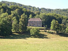 Chateau of Estang | |
 Coat of arms | |
show Location of Marmanhac | |
 Marmanhac | |
| Coordinates: 45°00′16″N 2°28′59″E / 45.0044°N 2.4831°ECoordinates: 45°00′16″N 2°28′59″E / 45.0044°N 2.4831°E | |
| Country | France |
| Region | Auvergne-Rhône-Alpes |
| Department | Cantal |
| Arrondissement | Aurillac |
| Canton | Naucelles |
| Intercommunality | CA Bassin d'Aurillac |
| Government | |
| • Mayor (2008–2014) | Laurent Tellier |
| Area 1 | 24.24 km2 (9.36 sq mi) |
| Population (Jan. 2018)[1] | 729 |
| • Density | 30/km2 (78/sq mi) |
| Time zone | UTC+01:00 (CET) |
| • Summer (DST) | UTC+02:00 (CEST) |
| INSEE/Postal code | 15118 /15250 |
| Elevation | 627–971 m (2,057–3,186 ft) |
| 1 French Land Register data, which excludes lakes, ponds, glaciers > 1 km2 (0.386 sq mi or 247 acres) and river estuaries. | |


Marmanhac is a commune in the Cantal department in south-central France.
Population[]
| Year | Pop. | ±% |
|---|---|---|
| 1962 | 841 | — |
| 1968 | 863 | +2.6% |
| 1975 | 890 | +3.1% |
| 1982 | 789 | −11.3% |
| 1990 | 749 | −5.1% |
| 1999 | 706 | −5.7% |
| 2008 | 736 | +4.2% |
See also[]
References[]
- ^ "Populations légales 2018". INSEE. 28 December 2020.
| Wikimedia Commons has media related to Marmanhac. |
This Cantal geographical article is a stub. You can help Wikipedia by . |
Categories:
- Communes of Cantal
- Cantal geography stubs