Saint-Constant-Fournoulès
Saint-Constant-Fournoulès | |
|---|---|
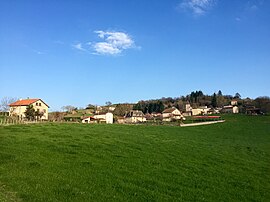 A general view of Fournoulès | |
Location of Saint-Constant-Fournoulès  | |
 Saint-Constant-Fournoulès | |
| Coordinates: 44°41′06″N 2°13′52″E / 44.685°N 2.231°ECoordinates: 44°41′06″N 2°13′52″E / 44.685°N 2.231°E | |
| Country | France |
| Region | Auvergne-Rhône-Alpes |
| Department | Cantal |
| Arrondissement | Aurillac |
| Canton | Maurs |
| Government | |
| • Mayor (2020–2026) | François Barrierre |
| Area 1 | 28.98 km2 (11.19 sq mi) |
| Population (Jan. 2018)[1] | 591 |
| • Density | 20/km2 (53/sq mi) |
| Time zone | UTC+01:00 (CET) |
| • Summer (DST) | UTC+02:00 (CEST) |
| INSEE/Postal code | 15181 /15600 |
| 1 French Land Register data, which excludes lakes, ponds, glaciers > 1 km2 (0.386 sq mi or 247 acres) and river estuaries. | |


Saint-Constant-Fournoulès (French pronunciation: [sɛ̃ kɔ̃stɑ̃ fuʁnulɛs]; Languedocien: Sant Constant e Fornolés) is a commune in the Cantal department of southern France. The municipality was established on 1 January 2016 and consists of the former communes of Saint-Constant and Fournoulès.[2]
See also[]
References[]
| Wikimedia Commons has media related to Saint-Constant-Fournoulès. |
- ^ "Populations légales 2018". The National Institute of Statistics and Economic Studies. 28 December 2020.
- ^ Arrêté préfectoral 4 December 2015 (in French)
This Cantal geographical article is a stub. You can help Wikipedia by . |
Categories:
- Communes of Cantal
- Populated places established in 2016
- Cantal geography stubs