Martinez, California
Martinez, California | |
|---|---|
City | |
| City of Martinez[1] | |
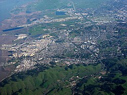 Aerial view of Martinez | |
 Location in Contra Costa County and the state of California | |
 Martinez Location in the United States | |
| Coordinates: 38°01′10″N 122°08′03″W / 38.01944°N 122.13417°WCoordinates: 38°01′10″N 122°08′03″W / 38.01944°N 122.13417°W | |
| Country | United States |
| State | California |
| County | Contra Costa |
| Incorporated | April 1, 1876[2] |
| Government | |
| • Mayor | Rob Schroder[3] |
| • State senator | Bill Dodd (D)[4] |
| • Assemblymember | Tim Grayson (D)[5] |
| • United States representatives | Mike Thompson (D) and Mark DeSaulnier (D)[6] |
| Area | |
| • Total | 13.63 sq mi (35.31 km2) |
| • Land | 12.63 sq mi (32.71 km2) |
| • Water | 1.00 sq mi (2.60 km2) 7.64% |
| Elevation | 23 ft (7 m) |
| Population | |
| • Total | 38,290 |
| • Density | 3,032.22/sq mi (1,170.74/km2) |
| Time zone | UTC-8 (Pacific) |
| • Summer (DST) | UTC-7 (PDT) |
| ZIP code | 94553 |
| Area code | 925 |
| FIPS code | 06-46114 |
| GNIS feature IDs | 277553, 2411045 |
| Website | Official website |


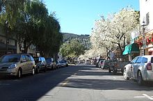
Martinez is a city in and the county seat of Contra Costa County, California, in the East Bay of the San Francisco Bay Area.[10] The population was 38,290 at the 2020 census. The city is named after Californio ranchero Ygnacio Martínez.[11] The downtown is notable for its large number of preserved old buildings and antique shops. Martinez is located on the southern shore of the Carquinez Strait in the San Francisco Bay Area, directly facing the city center of Benicia and the southeastern end of Vallejo, California.
History[]
In 1824, the western side of Martinez, Alhambra Valley was included in the Rancho El Pinole Mexican land grant to Ygnacio Martínez.[12] East of these lands was the Rancho Las Juntas, a grant made to Irish born William Welch in 1844; his land lay between the lands of Don Martinez and Don Pacheco.
In 1847, Dr. Robert Semple contracted to provide ferry service from Martinez to Benicia, which for many years was the only crossing on the Carquinez Strait.[12] By 1849, Martínez served as a way station for the California Gold Rush. The town was laid out in 1849 by Col. William M. Smith and named for Martinez.[13] It became the county seat in 1850, but could not incorporate at the time because it lacked the 200 registered voters required, and only became a city in 1876.[14]

Martinez was the home of naturalist John Muir from 1880 until his death in 1914. He was buried about a mile south of the building that is now the John Muir National Historic Site. Also nearby is the Vicente Martinez Adobe, built in 1849 by the son of Ygnacio Martinez.[14]
The first post office opened in 1851.[13]
In 1860, Martinez played a role in the Pony Express, where riders would take the ferry from Benicia (particularly if they missed the steamer in Sacramento).[15]
The first oil refinery in the Martinez area was built in 1904 at Bull's Head Point, a then-unincorporated waterfront area two miles east of the downtown district. That area soon became known as Mococo, following the 1905 arrival of a smelting works, operated by the Mountain Copper Company (Mo Co Co).
That first facility, operated by the Bull's Head Oil Company, was followed in 1908 by a test refinery built by the Pacific Coast Oil Company. Shortly thereafter, Pacific Coast became part of Standard Oil (now Chevron), and consolidated their oil refining operations in the Point Richmond, Hercules, Rodeo waterfront corridor some 12 miles to the west of Martinez.

In 1913, the Golden Eagle facility became the third oil refinery to be built in the area. It was located in the newly-created company town of Avon, immediately to the East of Martinez. A fourth refinery, built by the Shell Oil Company on land adjacent to the Martinez City limits, went online in January 1916. The Shell Oil refining facility is still operational today (Currently owned by PBF Energy), maintaining the position of Martinez as a significant petroleum processing center. The Golden Eagle Refinery (currently owned by Marathon Petroleum Company) was idled in April 2020 as a response to lower petroleum demand during the COVID-19 pandemic.[16][17][18]
Folk etymology in Martinez claims the invention of the Martini cocktail and that it is named for the city.[19]
Geography[]

According to the United States Census Bureau, the city has a total area of 13.1 square miles (34 km2), of which, 12.1 square miles (31 km2) of it is land and 1.0 square mile (2.6 km2) of it (7.64 percent) is water.
Although the common perception of Martinez is that of a refinery town, given the view from Highway 680 across the Shell refinery from the Benicia–Martinez Bridge, the city is in fact largely surrounded by water and regional open space preserves. The Martinez–Benicia Bridge carries Highway 680 across the eastern end of the Carquinez Strait to Solano County. The city can be defined as a more densely built downtown valley threaded by Alhambra Creek and north of Highway 4. Suburban areas stretch south of Highway 4 to join the neighboring city of Pleasant Hill. Unincorporated areas include the rural Alhambra Valley and the Franklin Canyon area.
The Martinez Regional Shoreline bounds the city to the north along the Carquinez Strait. Carquinez Strait Regional Shoreline includes the Franklin Hills west of downtown, stretching west to the unincorporated community of Port Costa and the town of Crockett. Briones Regional Park borders the Alhambra Valley to the south. Waterbird Regional Preserve and the border the city and Highway 680 to the east. Martinez's location at the east end of the Carquinez Strait as it widens to Suisun Bay includes dramatic water views stretching to the Sierra range. From surrounding ridge tops views stretch to nearby Mount Diablo, Mount Saint Helena, Mount Tamalpais, and others.
Martinez is one of the only two places in the Bay Area, the other being Golden Gate Bridge, where the Bay Area Ridge Trail and the San Francisco Bay Trail converge. The Bay Trail is a planned recreational corridor that, when complete, will encircle San Francisco and San Pablo bays with a continuous 400-mile (640 km) network of bicycling and hiking trails. It will connect the shoreline of all nine Bay Area counties, link 47 cities, and cross the major toll bridges in the region, including the Benicia–Martinez Bridge. To date, approximately 240 miles (390 km) of the alignment—over half the Bay Trail's ultimate length—have been completed. The Bay Area Ridge Trail ultimately will be a 500+ mile trail encircling the San Francisco Bay along the ridge tops, open to hikers, equestrians, mountain bicyclists, and outdoor enthusiasts of all types. So far, over 300 miles (480 km) of trail have been dedicated for use. East Bay Regional Park District's Iron Horse Regional Trail will join the Bay Trail along the waterfront, and the threads through the city from Pleasant Hill to the south.
Climate[]
Martinez has a mild mediterranean climate (Köppen climate classification Csa/b).[20] Summers are warm and dry, with some morning fog during sea breezes. The maritime influence is much less significant than in other parts of the Bay Area that are closer to the Pacific, which causes very high daytime averages compared to San Francisco and Oakland in summer. However, nights normally cool off significantly which results in daytime highs of around 87 °F (31 °C) and night time lows of 55 °F (13 °C) during July and August.[21] Winters are wet and cool with occasional frost. The majority of the city is within a USDA hardiness zone of 9b.
| hideClimate data for Martinez, California | |||||||||||||
|---|---|---|---|---|---|---|---|---|---|---|---|---|---|
| Month | Jan | Feb | Mar | Apr | May | Jun | Jul | Aug | Sep | Oct | Nov | Dec | Year |
| Record high °F (°C) | 83.0 (28.3) |
80.0 (26.7) |
88.0 (31.1) |
98.0 (36.7) |
104.0 (40.0) |
111.0 (43.9) |
115.0 (46.1) |
110.0 (43.3) |
108.0 (42.2) |
103.0 (39.4) |
86.0 (30.0) |
80.0 (26.7) |
115.0 (46.1) |
| Average high °F (°C) | 55.2 (12.9) |
60.9 (16.1) |
66.0 (18.9) |
71.7 (22.1) |
78.9 (26.1) |
85.3 (29.6) |
89.0 (31.7) |
88.7 (31.5) |
84.9 (29.4) |
76.4 (24.7) |
64.0 (17.8) |
55.6 (13.1) |
73.0 (22.8) |
| Average low °F (°C) | 38.6 (3.7) |
41.4 (5.2) |
44.1 (6.7) |
45.7 (7.6) |
49.5 (9.7) |
53.2 (11.8) |
54.5 (12.5) |
54.3 (12.4) |
53.3 (11.8) |
48.9 (9.4) |
43.2 (6.2) |
38.5 (3.6) |
47.1 (8.4) |
| Record low °F (°C) | 20.0 (−6.7) |
22.0 (−5.6) |
29.0 (−1.7) |
29.0 (−1.7) |
34.0 (1.1) |
40.0 (4.4) |
41.0 (5.0) |
42.0 (5.6) |
40.0 (4.4) |
34.0 (1.1) |
24.0 (−4.4) |
19.0 (−7.2) |
19.0 (−7.2) |
| Average precipitation inches (mm) | 3.93 (100) |
3.61 (92) |
2.92 (74) |
1.20 (30) |
.47 (12) |
.10 (2.5) |
.02 (0.51) |
.05 (1.3) |
.18 (4.6) |
.95 (24) |
2.52 (64) |
3.44 (87) |
19.37 (492) |
| Source: Western Regional Climate Center (1906-present) [22] | |||||||||||||
Demographics[]
| Historical population | |||
|---|---|---|---|
| Census | Pop. | %± | |
| 1870 | 560 | — | |
| 1890 | 1,609 | — | |
| 1900 | 1,380 | −14.2% | |
| 1910 | 2,115 | 53.3% | |
| 1920 | 3,858 | 82.4% | |
| 1930 | 6,569 | 70.3% | |
| 1940 | 7,381 | 12.4% | |
| 1950 | 8,268 | 12.0% | |
| 1960 | 9,604 | 16.2% | |
| 1970 | 16,506 | 71.9% | |
| 1980 | 22,582 | 36.8% | |
| 1990 | 31,808 | 40.9% | |
| 2000 | 35,866 | 12.8% | |
| 2010 | 35,824 | −0.1% | |
| 2020 | 38,290 | 6.9% | |
| U.S. Decennial Census[9] | |||

The 2020 United States Census[23] reported that Martinez had a population of 38,290. The population density was 2,727.4 people per square mile (1,053.1/km2). The racial makeup of Martinez was 27,603 (77.1%) White, 1,303 (3.6%) African American, 255 (0.7%) Native American, 2,876 (8.0%) Asian, 121 (0.3%) Pacific Islander, 1,425 (4.0%) from other races, and 2,241 (6.3%) from two or more races. Hispanic or Latino of any race were 5,258 persons (14.7 percent).
The Census reported that 34,528 people (96.4 percent of the population) lived in households, 235 (0.7 percent) lived in non-institutionalized group quarters, and 1,061 (3.0 percent) were institutionalized.
There were 14,287 households, out of which 4,273 (29.9 percent) had children under the age of 18 living in them, 6,782 (47.5 percent) were opposite-sex married couples living together, 1,751 (12.3 percent) had a female householder with no husband present, 640 (4.5 percent) had a male householder with no wife present. There were 928 (6.5 percent) unmarried opposite-sex partnerships, and 137 (1.0 percent) same-sex married couples or partnerships. 3,920 households (27.4 percent) were made up of individuals, and 1,078 (7.5 percent) had someone living alone who was 65 years of age or older. The average household size was 2.42. There were 9,173 families (64.2 percent of all households); the average family size was 2.95.
The age distribution of the population showed 7,329 people (20.5 percent) under the age of 18, 2,842 people (7.9 percent) aged 18 to 24, 9,193 people (25.7 percent) aged 25 to 44, 12,121 people (33.8 percent) aged 45 to 64, and 4,339 people (12.1 percent) who were 65 years of age or older. The median age was 42.2 years. For every 100 females, there were 96.9 males. For every 100 females age 18 and over, there were 94.8 males.
There were 14,976 housing units at an average density of 1,140.2 per square mile (440.2/km2), of which 14,287 were occupied, of which 9,619 (67.3 percent) were owner-occupied, and 4,668 (32.7 percent) were occupied by renters. The homeowner vacancy rate was 1.4 percent; the rental vacancy rate was 4.9 percent. 23,876 people (66.6 percent of the population) lived in owner-occupied housing units and 10,652 people (29.7 percent) lived in rental housing units.
|
Economy[]

Top employers[]
According to the City's 2009 Comprehensive Annual Financial Report,[26] the top employers in the city are:
| # | Employer | # of Employees |
|---|---|---|
| 1 | Contra Costa County | 9,847 |
| 2 | Shell Oil Company | 742 |
| 3 | Kaiser Permanente | 722 |
| 4 | Veterans Health Administration | 650 |
| 5 | Martinez Unified School District | 380 |
| 6 | Wal-Mart | 234 |
| 7 | Safeway | 174 |
| 8 | Contra Costa Electric | 150 |
| 9 | City of Martinez | 127 |
| 10 | The Home Depot | 120 |
Politics[]
In 2017, Martinez had 24,134 registered voters, with 11,897 (49.3%) registered as Democrats, 5,497 (22.8%) registered as Republicans, and 5,394 (22.4%) decline to state voters.[27]
Sister cities[]
According to Sister Cities International, Martinez is paired with:
Transportation[]
Rail[]


- Amtrak, the national passenger rail system, runs its California Zephyr daily in each direction through Martinez on its route between Emeryville (across the bay from San Francisco) and Chicago, also passing through Sacramento, Reno, Salt Lake City, Denver, and Omaha.
- Amtrak's Coast Starlight operates daily in each direction through Martinez between Seattle and Los Angeles.
- Amtrak California operates its Capitol Corridor trains through Martinez station, providing service several times daily between San Jose to the west and Auburn to the east (via Sacramento).
- Amtrak California also runs its San Joaquin trains through Martinez, providing service several times daily between Oakland to the west and Bakersfield at the south end of the San Joaquin Valley. Bus connections branch off both the San Joaquin and the Capitol Corridor, providing service as far as San Diego; Las Vegas and Sparks, Nevada; and Medford, Oregon. One connection originates in Martinez and runs as far north as the Eureka area.
- BART makes a stop called North Concord/Martinez station, although this station lies miles east of the Martinez city limits. The city was overlooked[weasel words] when the system was extended from Concord to Bay Point. However BART's long-term plans include a new line extension running from Fremont and through the I-680 corridor and ending in Martinez.[citation needed]
- The 1,600-foot (490 m)-long, 75-foot (23 m) high steel "Muir Trestle" (aka "Alhambra Trestle") carries the freight operations of the BNSF Railway through Martinez parallel to California State Route 4 (John Muir Parkway).
Bus[]
- WestCAT provides service to the El Cerrito del Norte BART station.
- The County Connection is the primary local bus operator providing service throughout the area. Among its destinations are the Concord, Pleasant Hill, and Walnut Creek BART stations. The County Connection also provides paratransit service.
- Tri Delta Transit runs express service between Martinez and eastern Contra Costa County.
Major highways[]
- State Route 4 runs through Martinez westward to Hercules and eastward through Stockton and the Sierra Nevada to near the border of Nevada.
- Interstate 680 runs northward across the Benicia–Martinez Bridge toward Sacramento via Interstate 80 and southward toward San Jose.
Media[]
Martinez and the surrounding area is served by several local newspapers, including the Martinez News-Gazette, the Martinez Tribune and the East Bay Times.
Martinez is also served by Martinez Patch, a local news website covering community news and events, and the local news and talk blog Claycord.com.
In December 2019, there was a flurry of reports from reliable sources including the Associated Press and the San Francisco Chronicle that the 161 year-old Martinez News-Gazette, one of the longest-running newspapers in California, may have to cease publication. But as of late May 2020, the threatened cessation did not materialize and the newspaper appears to have weathered that storm. The newspaper did cease publication of a print edition effective April 2, 2020 but this was characterized as a temporary measure arising from a lack of advertising revenue. This in turn arose as many local businesses were forced to suspended operations or even ceased to exist, when the area was under shelter in place regulations arising from the Coronavirus Covid-19 pandemic. The newspaper plans to resume a full print edition when the local shelter-in-place restrictions are lifted.[28] The newspaper continued to operate its online news website presence during the pandemic restrictions.
Education[]
Covering most of Martinez, the Martinez Unified School District encompasses four elementary schools, one middle school, one high school, and two alternative/independent study schools. Students in K-5 attend John Swett, John Muir, Las Juntas, or Morello Park Elementary School. Martinez Junior High School serves students in grades 6 through 8. St. Catherine of Siena is a private Catholic school that serves grades K-8. Alhambra High School serves as the district's comprehensive high school. As of 2006, the district's K-12 enrollment was 4,194. Part of Martinez is served by the Mount Diablo Unified School District, whose Hidden Valley Elementary School is located in Martinez. St. Catherine of Siena School (Martinez, California), a private Roman Catholic elementary, also serves the Martinez community.
Public libraries[]
The Martinez Library is part of the Contra Costa County Library and is located in Martinez. The Art Deco style building was placed on the National Register of Historic Places in early 2008.[29]
Notable people[]
- Maurice Benard, actor, known for playing Sonny Corinthos on General Hospital
- Yau-Man Chan, reality television star of Survivor Fiji
- Trevor Davis, wide receiver for the Miami Dolphins
- Sara Del Rey, professional wrestler
- Joe DiMaggio, Hall of Fame baseball player for New York Yankees, was born in Martinez in 1914
- Vince DiMaggio, All-Star baseball outfielder, older brother of Joe DiMaggio
- Ainjel Emme, musician
- Robb Flynn, Machine Head frontman
- Mark Kozelek, musician performing under the name Sun Kil Moon lives in the area and references it in many of his songs
- Ella Leffland, born Martinez 1931, author, The Knight, Death and The Devil (National Book Award winner), Rumors of Peace based on living in Martinez (called Mendoza) in World War II
- Tug McGraw, Major League Baseball pitcher, father of singer Tim McGraw
- John Muir, naturalist
- Richard Rodgers II, tight end for the Green Bay Packers
- Sabato "Simon" Rodia, creator of giant folk art Watts Towers in Los Angeles, spent the last ten years of his life in Martinez
- Victor Salva, film director
- J. Otto Seibold, children's book creator, including Olive, the Other Reindeer
- Robert Stephenson, professional baseball player
- Norv Turner, NFL head coach, and brother Ron, assistant coach for Chicago Bears, grew up in Martinez
- Jeff Van Gundy, NBA coach and TV commentator, and brother Stan Van Gundy, coach of Detroit Pistons, were raised in Martinez
- Travis Williams, kick returner for the Green Bay Packers
See also[]
- Martinez beavers
References[]
- ^ "Homepage". City of Martinez. Retrieved November 20, 2014.
- ^ "California Cities by Incorporation Date". California Association of Local Agency Formation Commissions. Archived from the original (Word) on November 3, 2014. Retrieved March 27, 2013.
- ^ "Mayor and City Council". City of Martinez. Retrieved March 21, 2013.
- ^ "Senators". State of California. Retrieved March 21, 2013.
- ^ "Members Assembly". State of California. Retrieved March 21, 2013.
- ^ "California's 11th Congressional District - Representatives & District Map". Civic Impulse, LLC. Retrieved September 28, 2014.
- ^ "2019 U.S. Gazetteer Files". United States Census Bureau. Retrieved July 1, 2020.
- ^ "Martinez". Geographic Names Information System. United States Geological Survey. Retrieved January 21, 2015.
- ^ Jump up to: a b "Martinez city, California". United States Census Bureau. Missing or empty
|url=(help) - ^ "Find a County". National Association of Counties. Archived from the original on May 31, 2011. Retrieved June 7, 2011.
- ^ Burt, Harriett; Perry, Charlene (January 4, 2012). "The Founder of the City of Martinez: Col. William Smith". Contra Costa County Historical Society. Retrieved March 12, 2021.
- ^ Jump up to: a b "Martinez Historical Society". Martinezhistory.org. Archived from the original on June 13, 2013. Retrieved July 14, 2013.
- ^ Jump up to: a b Durham, David L. (1998). California's Geographic Names: A Gazetteer of Historic and Modern Names of the State. Clovis, Calif.: Word Dancer Press. p. 660. ISBN 1-884995-14-4.
- ^ Jump up to: a b Martinez, CA, City History Archived August 2, 2015, at the Wayback Machine
- ^ "Martinez History and the Pony Express". Martinezhistory.org. Archived from the original on June 13, 2013. Retrieved July 14, 2013.
- ^ "California Refinery". Arb.ca.gov. Retrieved July 14, 2013.
- ^ "Welcome to Shell Martinez Refinery". shell.us. Shell Oil Company. Retrieved July 14, 2013.
- ^ City of Martinez (March 12, 2015). "Historic Resources of Martinez". Application to the National Register of Historic Places. Martinez City Council. p. 14 of 72. Retrieved March 8, 2018.
- ^ "The Martini Story". cityofmartinez.org. City of Martinez. Retrieved July 14, 2013.
- ^ "Martinez, California Climate Summary". Weatherbase. Retrieved March 6, 2015.
- ^ "Martinez, California Temperature Averages". Weatherbase. Retrieved March 6, 2015.
- ^ [1] Western Regional Climate Center Retrieved August 30, 2017
- ^ "2010 Census Interactive Population Search: CA – Martinez city". U.S. Census Bureau. Archived from the original on July 15, 2014. Retrieved July 12, 2014.
- ^ "Demographic Profile Bay Area Census". bayareacensus.ca.gov.
- ^ Farm Report: Contra Costa wines "After Prohibition was repealed, wineries began to open again in Contra Costa County, including J.E. Digardi Winery, Viano Vineyards and the J. Gonsalves Winery. Viano Vineyards has been making wine at their family winery ever since.
- ^ "City of Martinez CAFR". Retrieved July 14, 2013.
- ^ http://elections.cdn.sos.ca.gov/ror/ror-pages/ror-odd-year-2017/politicalsub.pdf
- ^ Jones, Rick (April 2, 2020). "Martinez News-Gazette to Suspend Print Edition [during Covid-19 pandemic shelter in place]". Martinez News-Gazette (Letter from the Publisher (Rick Jones) to the newspaper's subscribers). Retrieved May 27, 2020.
- ^ "National Register Information System". National Register of Historic Places. National Park Service. July 9, 2010. Retrieved January 12, 2017.
External links[]
 Definitions from Wiktionary
 Media from Wikimedia Commons
 News from Wikinews
 Quotations from Wikiquote
 Texts from Wikisource
 Textbooks from Wikibooks
 Travel guides from Wikivoyage
 Resources from Wikiversity
- Official website

- U.S. Geological Survey Geographic Names Information System: Martinez, California
- Martinez Area Chamber of Commerce
- Main Street Martinez
- Martinez, California Scenes, c.1927. Silent amateur film of daily life
| show Places adjacent to Martinez, California |
|---|
| show Municipalities and communities of Contra Costa County, California, United States |
|---|

| show San Francisco Bay Area |
|---|

| show Authority control |
|---|
- Martinez, California
- 1876 establishments in California
- Carquinez Strait
- Cities in Contra Costa County, California
- Cities in the San Francisco Bay Area
- County seats in California
- Incorporated cities and towns in California
- Pony Express stations
- Populated places established in 1849
- Populated places established in 1876
- Populated coastal places in California