Maryland's congressional districts

Maryland is divided into eight congressional districts, each represented by a member of the United States House of Representatives. After the 2020 Census, the number of Maryland's seats remained unchanged, giving evidence of stable population growth relative to the United States at large. Maryland is considered to be one of the most gerrymandered states in the country.[2] Gerrymandering in Maryland has long been done as a way to disproportionately favor the Democratic Party in congressional elections.[3]
Current (until 2023 inauguration) districts and representatives[]
List of members of the Marylander United States House delegation, their terms, their district boundaries, and the districts' political ratings according to the Cook Partisan Voting Index. The delegation has eight members, including seven Democrats and one Republican.
| Current U.S. representatives from Maryland ()
| |||||
|---|---|---|---|---|---|
| District | Member (Residence)[4] |
Party | Incumbent since | CPVI (2021)[5] |
District map |
| 1st |  Andy Harris (Cockeysville) |
Republican | January 3, 2011 | R+14 | 
|
| 2nd |  Dutch Ruppersberger (Cockeysville) |
Democratic | January 3, 2003 | D+13 | 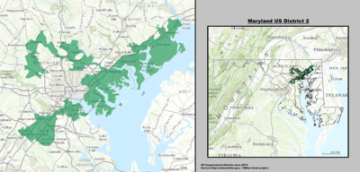
|
| 3rd |  John Sarbanes (Baltimore) |
Democratic | January 3, 2007 | D+16 | 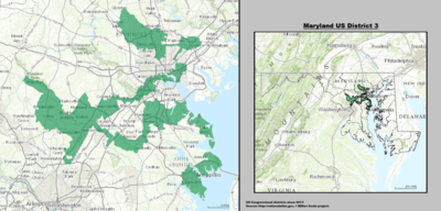
|
| 4th |  Anthony G. Brown (Bowie) |
Democratic | January 3, 2017 | D+29 | 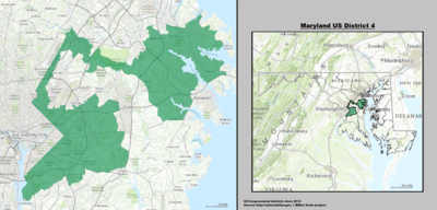
|
| 5th |  Steny Hoyer (Mechanicsville) |
Democratic | May 19, 1981 | D+16 | 
|
| 6th |  David Trone (Potomac) |
Democratic | January 3, 2019 | D+8 | 
|
| 7th |  Kweisi Mfume (Baltimore) |
Democratic | May 5, 2020 | D+27 | 
|
| 8th |  Jamie Raskin (Takoma Park) |
Democratic | January 3, 2017 | D+17 | 
|
Historical and present district boundaries[]
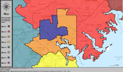
Table of United States congressional district boundary maps in the State of Maryland, presented chronologically.[6] All redistricting events that took place in Maryland between 1973 and 2013 are shown.
| Year | Statewide map | Baltimore highlight |
|---|---|---|
| 1973–1982 | 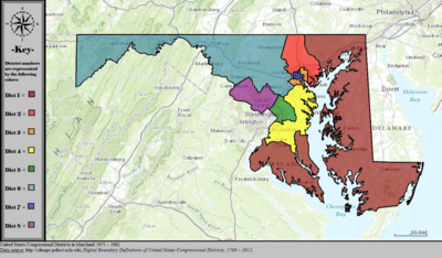
|
|
| 1983–1992 | 
|

|
| 1993–2002 | 
|

|
| 2003–2013 | 
|

|
| Since 2013 | 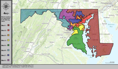
|

|
Obsolete districts[]
See also[]
References[]
- ^ "The national atlas". nationalatlas.gov. Archived from the original on February 22, 2014. Retrieved February 2, 2014.
- ^ Ingraham, Christopher. "America's most gerrymandered congressional districts". The Washington Post. Retrieved 16 July 2015.
- ^ Ingraham, Christopher. "How Maryland Democrats pulled off their aggressive gerrymander". The Washington Post. Retrieved May 2, 2021.
- ^ "Office of the Clerk, U.S. House of Representatives". clerk.house.gov. Retrieved 2022-01-06.
- ^ "Introducing the 2021 Cook Political Report Partisan Voter Index". Cook Political Report. Retrieved 2022-01-06.
- ^ "Digital Boundary Definitions of United States Congressional Districts, 1789–2012". Retrieved October 18, 2014.
- Congressional districts of Maryland