Bowie, Maryland
Bowie, Maryland | |
|---|---|
City | |
| City of Bowie | |
 Old Town Bowie, as seen from the intersection of Maryland Route 564 and Chapel Avenue in January 2008 | |
 Seal | |
| Motto(s): "Growth, Unity and Progress" | |
 Location of Bowie in Prince George's County and the State of Maryland | |
 Bowie Location within the State of Maryland | |
| Coordinates: 38°57′53″N 76°44′40″W / 38.96472°N 76.74444°WCoordinates: 38°57′53″N 76°44′40″W / 38.96472°N 76.74444°W | |
| Country | |
| State | |
| County | |
| Incorporated | 1882[1] |
| Government | |
| • Mayor | Timothy Adams |
| Area | |
| • Total | 20.55 sq mi (53.23 km2) |
| • Land | 20.45 sq mi (52.96 km2) |
| • Water | 0.10 sq mi (0.27 km2) |
| Elevation | 154 ft (47 m) |
| Population | |
| • Total | 54,727 |
| • Estimate (2019)[4] | 58,643 |
| • Density | 2,867.77/sq mi (1,107.27/km2) |
| Time zone | UTC−5 (EST) |
| • Summer (DST) | UTC−4 (EDT) |
| ZIP codes | 20715-20721 |
| Area code(s) | 301, 240 |
| FIPS code | 24-08775 |
| GNIS feature ID | 0597104 |
| Website | www.CityofBowie.org |


Bowie (/ˈbuːi/) is a city in Prince George's County, Maryland, United States.[5] The population was 54,727 at the 2010 U.S. Census. Bowie has grown from a small railroad stop to the largest municipality in Prince George's County, and the fifth most populous city[6] and third largest city by area in the U.S. state of Maryland. In 2014, CNN Money ranked Bowie 28th in its Best Places to Live (in the United States) list.[7]
History[]
19th century[]
The city of Bowie owes its existence to the railway. In 1853, Colonel William Duckett Bowie obtained a charter from the Maryland legislature to construct a rail line into Southern Maryland. In 1869, the Baltimore & Potomac Railroad Company began the construction of a railroad from Baltimore to Southern Maryland, terminating in Pope's Creek. The area had already been dotted with small farms and large tobacco plantations in an economy based on agriculture and slavery. In 1870, Ben Plumb, a land speculator and developer, sold building lots around the railroad junction and named the settlement Huntington City. By 1872, the line was completed, together with a "spur" to Washington, D.C. and the entire line through Southern Maryland was completed in 1873.
In 1880, Huntington City was rechartered as Bowie, named for Colonel Bowie's son and business partner Oden Bowie,[8][9][10][11] the former Governor of Maryland[12] and then-president of the Baltimore & Potomac Railroad.[13] In the early days the land was subdivided by developers into more than 500 residential building lots, to create a large town site at a junction of the Baltimore and Potomac's main line to southern Maryland, and the branch line to Washington, D.C.
20th century[]
This section needs additional citations for verification. (January 2013) |
By 1902 the Baltimore & Potomac was purchased by the powerful Pennsylvania Railroad. A second railroad entered the community when the Washington, Baltimore and Annapolis Electric Railway electric trolley line commenced service in 1908. The large interurban cars brought rapid transit to the area, with trains running hourly. Bowie area stations included High Bridge, Hillmeade, and the Race Track.
The convergence of the two rail systems induced the Southern Maryland Agricultural Society to build the Bowie Race Track in 1914. The track enabled the Belair Stud to become one of Maryland's premier areas for thoroughbreds. Also in 1914, a teacher-training college, or normal school as it was referred to then, was built for African-Americans, just outside the town. This now has become Bowie State University. The town of Bowie was incorporated in 1916.
Belair at Bowie[]
In 1957, the firm of Levitt and Sons acquired the nearby Belair Estate, the original colonial plantation of the Provincial Governor of Maryland, Samuel Ogle, and developed the residential community of Belair at Bowie. Two years later the town of Bowie annexed the Levitt properties and then re-incorporated the now-larger area as a city in 1963. The overwhelming majority of Bowie residents today live in this 1960s Levitt planned community, whose street names are arranged in alliterative sections.[14] Levitt & Sons had a long history of prohibiting the sale of houses (including resale by owners) to African Americans which led to protests during the Civil Rights Movement in Bowie in 1963.[15]
Belair Estate[]
The original Belair Estate contains the Belair Mansion (circa 1745), the five-part Georgian plantation house of Governor Samuel Ogle and his son Governor Benjamin Ogle. It was purchased in 1898 by the wealthy banker James T. Woodward who, on his passing in 1910, left it to his nephew, William Woodward, Sr., who became a famous horseman. Restored to reflect its 250-year-old legacy, the Mansion is listed on the National Register of Historic Places.
Belair Stable, on the Estate, was part of the famous Belair Stud, one of the premier racing stables in the 1930s, '40s, and '50s. Owned and operated by William Woodward, Sr. (1876–1953), it closed in 1957 following the death of his son, Billy Woodward. Belair had been the oldest continually operating thoroughbred horse farm in the country.[citation needed]
21st century[]
This section needs additional citations for verification. (January 2013) |
Bowie has an area of 16 square miles (41 km2) and about 50,000 residents with nearly 2,000 acres (8.1 km2) set aside as parks or open space. It has 72 ball fields, three community centers, an ice arena at Allen Pond Park, the Bowie Town Center, the 800-seat Bowie Center for the Performing Arts,[16] a 150-seat theatrical playhouse, a golf course, and three museums.
Bowie's rail town history is on display via the Huntington Railroad Museum, within the local rail station's restored railroad buildings. In 2006, the city reopened the Bowie Building Association building, a small brick and block structure constructed circa 1930, as a Welcome Center; it originally housed the Bowie Building Association, which helped finance much of the community's early development.
Bowie is home to the Bowie Baysox, a Class AA Eastern League professional baseball team affiliated with the Baltimore Orioles. The Baysox moved to Bowie from Hagerstown in 1993 and began to play at Prince George's Stadium in 1994. In 2015, the Baysox captured their first Eastern League Championship, defeating the Reading Fightin Phils in five games.
The city operates a senior citizens center and a gymnasium for community programs.
Geography[]

Bowie is located at 38°57′53″N 76°44′40″W / 38.96472°N 76.74444°W (38.964727, −76.744531).[17]
According to the United States Census Bureau, the city has a total area of 18.51 square miles (47.94 km2), of which 18.43 square miles (47.73 km2) is land and 0.08 square miles (0.21 km2) is water.[18]
Adjacent areas[]
- Glenn Dale (northwest)
- South Laurel (northwest)
- Crofton (northeast)
- Davidsonville (east)
- Queen Anne (southeast)[dubious ][citation needed]
- Brock Hall (south)
- Kettering (southwest)
- Woodmore (southwest)
- Fairwood (west)
ZIP codes[]
ZIP codes for mail delivery in Bowie are: 20715, 20716, 20717, 20718, 20719, 20720, 20721
Climate[]
The climate in this area is characterized by hot, humid summers and generally mild to cool winters. According to the Köppen Climate Classification system, Bowie has a humid subtropical climate, abbreviated "Cfa" on climate maps.[19]
Demographics[]
| Historical population | |||
|---|---|---|---|
| Census | Pop. | %± | |
| 1920 | 677 | — | |
| 1930 | 694 | 2.5% | |
| 1940 | 767 | 10.5% | |
| 1950 | 860 | 12.1% | |
| 1960 | 1,072 | 24.7% | |
| 1970 | 35,028 | 3,167.5% | |
| 1980 | 33,695 | −3.8% | |
| 1990 | 37,589 | 11.6% | |
| 2000 | 50,269 | 33.7% | |
| 2010 | 54,727 | 8.9% | |
| 2019 (est.) | 58,643 | [4] | 7.2% |
| U.S. Decennial Census[20] 2018 Estimate[21] | |||
According to a 2007 estimate, the median income for a household in the city was $99,105, and the median income for a family was $109,157. Males had a median income of $52,284 versus $40,471 for females. The per capita income for the city was $30,703. About 0.7% of families and 1.6% of the population were below the poverty line, including 1.0% of those under age 18 and 1.8% of those age 65 or over.
- Rank by per capita income in Prince George's County: 7
- Rank by per capita income in Maryland: 65
2010 census[]
As of the census[3] of 2010, there were 54,727 people, 19,950 households, and 14,264 families residing in the city. The population density was 2,969.5 inhabitants per square mile (1,146.5/km2). There were 20,687 housing units at an average density of 1,122.5 per square mile (433.4/km2).
The ethnic makeup of the city was 41.4% White, 48.7% African American, 0.3% Native American, 4.1% Asian, 0.1% Pacific Islander, 1.9% from other races, and 3.6% from two or more races. Hispanic or Latino of any race were 5.6% of the population.
There were 19,950 households, of which 37.0% had children under the age of 18 living with them, 53.2% were married couples living together, 14.0% had a female householder with no husband present, 4.3% had a male householder with no wife present, and 28.5% were non-families. 23.4% of all households were made up of individuals, and 7.7% had someone living alone who was 65 years of age or older. The average household size was 2.73 and the average family size was 3.23.
The median age in the city was 40.1 years. 24.5% of residents were under the age of 18; 7.6% were between the ages of 18 and 24; 26.2% were from 25 to 44; 30.1% were from 45 to 64; and 11.6% were 65 years of age or older. The gender makeup of the city was 46.9% male and 53.1% female.
Government[]
The City of Bowie operates under a council-manager government as established by the city charter. This means that the mayor and council are responsible for making policy, passing ordinances, voting appropriations, and having overall supervisory authority in the city government.
The U.S. Postal Service operates multiple post offices including Mitchellville,[22] West Bowie,[23] and Bowie/Mitchellville Carrier Annex (adjacent to the city limits).[24][25]
Law enforcement[]
The primary law enforcement agency for the city is the Bowie Police Department aided by the Prince George's County Police, the Maryland-National Capital Park Police Department, and the Sheriff's Office as directed by authority.
Prince George's County Police Department District 2 Station in Brock Hall CDP, with a Bowie postal address, serves the community.[26]
Transportation[]
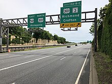
Bowie is served by several significant highways. The most prominent of these is Interstate 595/U.S. Route 50, the John Hanson Highway, which follows an east–west route through the city. Via I-595/US 50, Bowie has direct connections westward to Washington, D.C. and eastward to Annapolis and the Eastern Shore of Maryland. U.S. Route 301 and Maryland Route 3 skim the eastern edge of the city, providing connections southward to Waldorf and La Plata and northward to Baltimore. Other state highways serving the city include Maryland Route 197, Maryland Route 214, Maryland Route 450 and Maryland Route 564.
It is served by Bowie State station on MARC's Penn Line.
Economy[]
Largest employers[]
According to the city's 2018 Comprehensive Annual Financial Report,[27] the largest employers in the city are:
| # | Employer | # of Employees |
|---|---|---|
| 1 | Prince George's County Public Schools | 1,178 |
| 2 | Inovalon | 605 |
| 3 | City of Bowie | 446 |
| 4 | Bowie Baysox | 260 |
| 5 | P.G. County Public Safety Communications Control | 195 |
Education[]
Primary and secondary schools[]
Public schools[]
Bowie is within the Prince George's County Public Schools system.[28]
Area residents are zoned to Benjamin Tasker Middle School or Samuel Ogle Middle School,[29] and Bowie High School.[30] Some Bowie residents also attend Eleanor Roosevelt High School in their STEM program.[citation needed]
Elementary schools in Bowie include Heather Hills, Kenilworth, Northview, Pointer Ridge, Rockledge, Tulip Grove, Whitehall, and Yorktown Elementary Schools. Elementary schools not in Bowie and serving Bowie include High Bridge and Woodmore.[28][31] Two special education centers are Chapel Forge and C. Elizabeth Reig. A voc/tech school is located at Tall Oaks High School.
Samuel Ogle was previously a junior high school, then an elementary school; around 2005, PGCPS planned to convert it into a middle school.[32]
From 1950 to 1964, during the era of legally-required racial segregation of schools, black students from Bowie attended Fairmont Heights High School, then near Fairmount Heights.[33]
Private schools[]
Bowie is home to several private schools:
- Ascension Day Care and Kindergarten
- Belair Baptist Christian Academy
- Bowie Montessori Children's House
- Christian Community Presbyterian Church Nursery School
- Cornerstone Christian Academy
- Cresthill Christian Academy
- Grace Christian School (Grades K–8)
- Holy Trinity Episcopal Day School
- Patuxent Montessori School
- Redeemer Child Care Center
- St. Matthew's Early Education Center
- St. Pius X Regional School (Grades Pre K–8)
Colleges and universities[]
Bowie State University, located north of Bowie, has been open since 1865.
Public libraries[]
Prince George's County Memorial Library System operates two public libraries in Bowie: Bowie Branch and South Bowie Branch.[34][35]
Notable people[]
- Richard (Ricky) Arnold, NASA astronaut[36]
- Michael Bray, convicted conspirator in numerous bombings[37]
- Eva Cassidy, singer and songwriter[38]
- Daniel "Jungleman" Cates, professional poker player[39]
- JC Chasez, singer and former member of *NSYNC[40]
- Anthony Cowan Jr., point guard for the Maryland Terrapins men's basketball team, 3-time all-Big Ten selection (2018–2020)[41]
- Francis B. Francois, engineer and politician[42]
- Kathie Lee Gifford, television host, singer, songwriter, comedian, and actress[43]
Sports[]
| Team | Sport | League | Championships | Venue |
|---|---|---|---|---|
| Bowie Baysox | Baseball | Eastern League | 1 (2015) | Prince George's Stadium |
Historic sites[]
The following is a list of historic sites in the city of Bowie and vicinity identified by the Maryland-National Capital Park and Planning Commission:[44]
| Site Name | Image | Location | M-NCPPC Inventory Number | Comments | |
|---|---|---|---|---|---|
| 1 | Belair | 
|
Tulip Grove and Belair Drives | 71B-004 | Listed on the National Register of Historic Places, 1977-09-16 |
| 2 | Belair Stables | 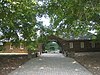
|
Belair Drive | 71B-005 | Listed on the National Register of Historic Places, 1973-05-08 |
| 3 | Bowie Railroad Buildings | 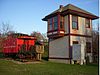
|
8614 Chestnut Ave. | 71B-002-09 | Listed on the National Register of Historic Places, 1998-11-04 |
| 4 | 6501 Hillmeade Road | 71A-034 | |||
| 5 | 7704 Laurel-Bowie Road | 71B-015 | |||
| 6 | Fairview Plantation | 
|
4600 Fairview Vista Drive | 71A-013 | |
| 7 | Don S. S. Goodloe House | 
|
13809 Jericho Park Rd. | 71A-030 | Listed on the National Register of Historic Places, 1988-10-13; African American Heritage site |
| 8 | Governor's Bridge | 
|
Governors Bridge Road at Patuxent River | 74B-001 | Historic American Engineering Record,[45]
Maryland Historical Trust[46] |
| 9 | 8706 Maple Avenue | 71B-002-08 | |||
| 10 | Holy Trinity Episcopal Church | 
|
13104 Annapolis Road | 71A-009a | |
| 11 | Holy Trinity Church Rectory | 13106 Annapolis Road | 71A-009b | ||
| 12 | 9006 Laurel-Bowie Road | 71A-003 | |||
| 13 | 13004 12th Street | 71B-002-23 | |||
| 14 | Melford | 
|
17107 Melford Boulevard | 71B-016 | Listed on the National Register of Historic Places, 1988-04-06; also listed at Mitchellville |
| 15 | 2608 Mitchellville Road | 71B-007 | |||
| 16 | 13125 11th Street | 71B-002-03 | |||
| 17 | Sacred Heart Catholic Church | 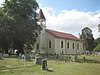
|
16101 Annapolis Road | 71A-019 | Site where the Catholic Church in America was first organized, and the first US Catholic Bishop, John Carroll was petitioned, then named by the Vatican. |
| 18 | 9201 Laurel-Bowie Road | 71A-002 | |||
| 19 | 13010 8th Street | 71B-002-05 | |||
| 20 | 13005 7th Street | 71B-002-01 | |||
| 21 | Williams Plains | 
|
MD 3, White Marsh Recreational Park | 71B-003 | Listed on the National Register of Historic Places, 1980-11-28 |
| 22 | Pleasant Prospect | 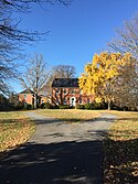 |
12806 Woodmore Rd.,Mitchellville, Maryland | 74A-006 | Listed on the National Register of Historic Places, April 30, 1976 |
Parks[]
- Allen Pond Park
- Foxhill Park
- Buckingham Park
- Somerset Park
- Whitemarsh Park
- Jericho Park
Sister Cities[]
| Wikivoyage has a travel guide for Bowie. |
In June 2016, Mayor Robinson gave honorary Bowie citizenship to Mayor Luigi Lucchi of Berceto, Italy as part of an International Youth Festival being held there.[47]
References[]
- ^ "Bowie". Maryland Manual. Retrieved 27 June 2017.
- ^ "2019 U.S. Gazetteer Files". United States Census Bureau. Retrieved July 25, 2020.
- ^ Jump up to: a b "U.S. Census website". United States Census Bureau. Retrieved 2013-01-25.
- ^ Jump up to: a b "Population and Housing Unit Estimates". United States Census Bureau. May 24, 2020. Retrieved May 27, 2020.
- ^ "Bowie". Geographic Names Information System. United States Geological Survey.
- ^ "Annual Estimates of the Population for Incorporated Places in Maryland, Listed Alphabetically". United States Census Bureau. July 1, 2006. Archived from the original on November 5, 2007. Retrieved August 29, 2015.
- ^ "Best Places to Live 2014". Money. September 19, 2014. Retrieved September 22, 2014.
- ^ "Revitalization of Old Town Bowie". City of Bowie, Maryland. Archived from the original on 2007-07-20. Retrieved 2007-10-02.
- ^ "The Prince George's Hall of Fame". Prince George's County Historical Society. 2003. Archived from the original on 2007-09-24. Retrieved 2007-08-16.
- ^ "Prince George's County: Over 300 years of History – Oden Bowie". Prince George's County Historical Society. 1996. Retrieved 2007-10-02.
- ^ Wilson, William Bender (1895). History of the Pennsylvania Railroad Company: With Plan of Organization. Henry T. Coates & Company. p. 279.
- ^ "Governor's Information: Maryland Governor Oden Bowie". National Governors Association. Archived from the original on 2009-02-07. Retrieved 2007-10-02.
- ^ Wilson, William Bender (1895). History of the Pennsylvania Railroad Company: With Plan of Organization. Henry T. Coates & Company. pp. 333–334.
- ^ Jacobs, James A. "Belair at Bowie". Society of Architectural Historians Archipedia. University of Virginia Press. Archived from the original on 29 August 2018. Retrieved 28 August 2018.
- ^ Suburban Legend WILLIAM LEVITT
- ^ http://www.bowiecenter.org
- ^ "US Gazetteer files: 2010, 2000, and 1990". United States Census Bureau. 2011-02-12. Retrieved 2011-04-23.
- ^ "US Gazetteer files 2010". United States Census Bureau. Archived from the original on 2012-01-25. Retrieved 2013-01-25.
- ^ Climate Summary for Bowie, Maryland
- ^ United States Census Bureau. "Census of Population and Housing". Retrieved June 24, 2015.
- ^ "Population Estimates". United States Census Bureau. Retrieved June 8, 2018.
- ^ "MITCHELLVILLE." U.S. Postal Service. Retrieved on September 11, 2018. "1500 POINTER RIDGE PL BOWIE, MD 20716-9998"
- ^ "WEST BOWIE." U.S. Postal Service. Retrieved on September 11, 2018. "13030 9TH ST BOWIE, MD 20720-3645"
- ^ "BOWIE." U.S. Postal Service. Retrieved on September 11, 2018. "6710 LAUREL BOWIE RD BOWIE, MD 20715-9997"
- ^ "MITCHELLVILLE CARRIER ANNEX." U.S. Postal Service. Retrieved on September 11, 2018. "6710 LAUREL BOWIE RD BOWIE, MD 20715-9998"
- ^ "District 2 Station – Bowie." Prince George's County Police Department. Retrieved on September 9, 2018. "District 2 Station – Bowie 601 SW Crain Highway Bowie, MD 20715 ". Beat map. 2010 U.S. Census Bureau index map of Brock Hall CDP as well as the detail on Page 1.
- ^ "2018 Comprehensive Annual Financial Report" (PDF). City of Bowie. October 26, 2018. Retrieved 23 February 2019.
- ^ Jump up to: a b "Bowie Neighborhoods." City of Bowie. Retrieved on August 28, 2018. This map indicates the locations of schools.
- ^ "NEIGHBORHOOD MIDDLE SCHOOLS AND BOUNDARIES SCHOOL YEAR 2018-2019." Prince George's County Public Schools. Retrieved on August 26, 2018.
- ^ "NEIGHBORHOOD HIGH SCHOOLS AND BOUNDARIES SCHOOL YEAR 2018-2019." Prince George's County Public Schools. Retrieved on August 26, 2018.
- ^ "NEIGHBORHOOD ELEMENTARY SCHOOLS AND BOUNDARIES SCHOOL YEAR 2018-2019." Prince George's County Public Schools. Retrieved on August 26, 2018.
- ^ Moore, Marcus (2005-03-24). "Bowie boundary changes evoke anger". The Gazette. Archived from the original on 2018-09-08. Retrieved 2018-09-09.
- ^ "Fairmont Heights High School History". Fairmont Heights High School. 2018-09-04. Archived from the original on 2005-10-04. Retrieved 2018-09-04.
- ^ "Bowie Branch." Prince George's County Memorial Library System. Retrieved on August 29, 2018.
- ^ "South Bowie Branch." Prince George's County Memorial Library System. Retrieved on August 29, 2018.
- ^ Whiting, Melanie (2016-01-29). "Richard R. Arnold II". NASA. Retrieved 2018-08-24.
- ^ https://www.washingtonpost.com/archive/local/1989/07/26/from-prison-back-to-pg-pulpit/c8dff09d-9cbf-4a4b-b061-e5eaf7bb2f09/
- ^ Songbird Sherri Dalphonse, Washingtonian, May 1, 2001. Retrieved on September 3, 2013.
- ^ Jay Caspian Kang (March 25, 2011). "Online Poker's Big Winner". The New York Times.
- ^ Cruz, Anne Marie (April 5, 2004). "Hit Single". People. Time, Inc. Retrieved December 21, 2013.
As a kid in suburban Bowie, Md....
- ^ David Driver (December 5, 2018). "Bowie product Cowan steps up his game with Maryland men's basketball". Capital Gazette.
- ^ Diehl, Jackson (October 14, 1978). "The Rise And Fall of Levitt Era". The Washington Post. Retrieved October 14, 2019.
- ^ Gleick, Elizabeth (November 2, 1992). "Kathie Lee's Story". People. Vol. 38 no. 18. Time, Inc. Retrieved December 21, 2013.
When Kathie Lee was 4, the family... set up house in Bowie, Md.
- ^ M-NCPPC Illustrated Inventory of Historic Sites (Prince George's County, Maryland), 2006 Archived 2008-07-25 at the Wayback Machine.
- ^ Lavoie, Catherine C. (1992). Historic American Engineering Record, Governor's Bridge, HAER NO. MD-85 (PDF). Washington, D.C.: National Park Service, Department of the Interior. pp. 1, 2. Archived from the original (PDF) on 2013-11-04. Retrieved 2013-01-19.
- ^ Maryland Historical Trust Property Number PG-74B-1 & AA-85I (PDF), Maryland Inventory of Historic Bridges, retrieved 5 January 2013
- ^ "Berceto, Cittadinanza Onoraria del Bowie a Lucchi" [Berceto: Lucchi Receives Honorary Bowie Citizenship]. il Parmense (in Italian). June 14, 2016. Retrieved July 19, 2016.
External links[]
| Wikimedia Commons has media related to Bowie, Maryland. |
- Official website
- John Zug surveys at the University of Maryland Libraries. Zug surveyed the land that was to become Bowie

|
Laurel Glenn Dale |
Crofton |
Davidsonville |
| |||
| Washington, D.C. |
Annapolis | ||||||
| Woodmore |
Upper Marlboro |
Harwood |
| show Municipalities and communities of Prince George's County, Maryland, United States |
|---|


| show Authority control |
|---|
- Bowie, Maryland
- 1870 establishments in Maryland
- Cities in Maryland
- Populated places established in 1870
- Cities in Prince George's County, Maryland
- Washington metropolitan area
- Levittown