Croom, Maryland
Croom | |
|---|---|
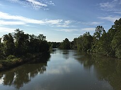 The Patuxent River forms the eastern boundary of Croom | |
 Croom Location within the state of Maryland | |
| Coordinates: 38°45′9″N 76°45′50″W / 38.75250°N 76.76389°WCoordinates: 38°45′9″N 76°45′50″W / 38.75250°N 76.76389°W | |
| Country | |
| State | |
| County | |
| Area | |
| • Total | 91.7 km2 (35.4 sq mi) |
| • Land | 88.6 km2 (34.2 sq mi) |
| • Water | 3.1 km2 (1.2 sq mi) |
| Population (2010) | |
| • Total | 2,631 |
| • Density | 29/km2 (74/sq mi) |
| Time zone | UTC−5 (Eastern (EST)) |
| • Summer (DST) | UTC−4 (EDT) |
| GNIS feature ID | 597296 |


Croom is an unincorporated community and census-designated place in Prince George's County, Maryland, United States.[1] As of the 2010 census it had a population of 2,631.[2] Croom largely consists of former tobacco farms and forests converted to Washington bedroom subdivisions such as nearby Marlton. The main (Jug Bay Natural Area) part of Patuxent River Park is in Croom.
History[]
The community was patented in 1671 as Croome by Christopher Rousby,[3] who had been born circa 1642 in the hamlet of Croome in East Riding, Yorkshire.[4] In August 1814, British forces marched through Croom on their way to the Burning of Washington in the War of 1812.[3]
St. Thomas' Episcopal Church dates to colonial times and was listed on the NRHP in 2000. Other buildings on the National Register of Historic Places located at Croom are the John W. Coffren House and Store, Bellefields, Brookefield of the Berrys, Mattaponi (John Bowie Jr. House), St. Thomas' Episcopal Parish Historic District, and Waverly.[5][6]
The Columbia Air Center was located in Croom from 1941-1956.[7] It was among the first African-American owned airports in the United States.
Geography[]
According to the United States Census Bureau, Croom has a total area of 35.4 square miles (91.7 km2), of which 34.2 square miles (88.6 km2) is land and 1.2 square miles (3.1 km2), or 3.43%, is water.[8]
Government[]
Prince George's County Police Department District 5 Station in Clinton CDP serves the community.[9]
Education[]
Prince George's County Public Schools operates public schools serving the census-designated place.[10]
Elementary schools serving sections of Croom are Baden, Brandywine, Marlton, Mattaponi, and Patuxent.[11] Most areas are zoned to Gwynn Park Middle School, with some zoned to James Madison Middle School and Kettering Middle School.[12] Most areas are zoned to Frederick Douglass High School in Croom, with some areas to the north zoned to Dr. Henry A Wise, Jr. High School and some to the south zoned to Gwynn Park High School.[13]
Notable people[]
- William Duckett Bowie (1803–1873), politician[14]
- Robert Bowie, governor of Maryland (1750–1818)[citation needed]
- William Williams (c. 1793–1814), an escaped slave who enlisted in 38th United States Colored Infantry Regiment and died from his wounds after the British bombardment of Fort McHenry in the War of 1812.
References[]
- ^ U.S. Geological Survey Geographic Names Information System: Croom, Maryland
- ^ "Profile of General Population and Housing Characteristics: 2010 Demographic Profile Data (DP-1): Croom CDP, Maryland". United States Census Bureau. Retrieved December 19, 2011.
- ^ Jump up to: a b "Croom". Historical Marker Project. 3RiverDev. Retrieved 2019-05-27.
Christopher Rousby patented Croome in 1671. Home of Thomas John Claggett (1743-1816). First Episcopal Bishop of Maryland (1792), First Protestant Bishop consecrated in the United States, And first Chaplain of the US Senate. In August 1814 British forces marched through before burning Washington. Croom Post Office established in 1855. By 1873 a stop on the Pope's Creek branch of the Baltimore & Potomac Railroad.
- ^ "Rousby Genealogy". WikiTree. Interesting.com. Retrieved 2019-05-27.
- ^ "National Register Information System". National Register of Historic Places. National Park Service. July 9, 2010.
- ^ "National Register of Historic Places Listings". Weekly List of Actions Taken on Properties: 12/27/11 through 12/30/11. National Park Service. 2012-01-06. Archived from the original on 2015-10-05.
- ^ Maryland-National Capital Park and Planning Commission (June 2010). "Approved Historic Sites and District Plan" (PDF): 153. Retrieved 15 August 2012. Cite journal requires
|journal=(help) - ^ "Geographic Identifiers: 2010 Demographic Profile Data (DP-1): Croom CDP, Maryland". United States Census Bureau. Retrieved December 19, 2011.
- ^ "District 5 Station - Clinton." Prince George's County Police Department. Retrieved on September 9, 2018. " 6707 Groveton Drive Clinton, MD 20735". Beat map. See 2010 U.S. Census index map of Clinton CDP: area with police station is on the edge of page 6 with surroundings on page 5.
- ^ "2010 CENSUS - CENSUS BLOCK MAP (INDEX): Croom CDP, MD." U.S. Census Bureau. Retrieved on August 28, 2018. Pages: 1, 2, 3, and 4.
- ^ "NEIGHBORHOOD ELEMENTARY SCHOOLS AND BOUNDARIES SCHOOL YEAR 2018-2019." Prince George's County Public Schools. Retrieved on August 26, 2018.
- ^ "NEIGHBORHOOD MIDDLE SCHOOLS AND BOUNDARIES SCHOOL YEAR 2018-2019." Prince George's County Public Schools. Retrieved on August 26, 2018.
- ^ "NEIGHBORHOOD HIGH SCHOOLS AND BOUNDARIES SCHOOL YEAR 2018-2019." Prince George's County Public Schools. Retrieved on August 26, 2018.
- ^ Spencer, Richard Henry (1919). Genealogical and Memorial Encyclopedia of the State of Maryland. New York: American Historical Society. pp. 392. ISBN 0-8328-5943-5.
general thomas f bowie.
| Wikimedia Commons has media related to Croom, Maryland. |
| show Municipalities and communities of Prince George's County, Maryland, United States |
|---|

| show Authority control |
|---|
- Census-designated places in Maryland
- Census-designated places in Prince George's County, Maryland