Berwyn Heights, Maryland
Berwyn Heights, Maryland
Town of Berwyn Heights | |
|---|---|
Town | |
 Seal | |
| Motto(s): A Tree City, U.S.A. | |
 Location of Berwyn Heights, Maryland | |
| Coordinates: 38°59′38″N 76°54′44″W / 38.99389°N 76.91222°WCoordinates: 38°59′38″N 76°54′44″W / 38.99389°N 76.91222°W | |
| Country | |
| State | |
| County | |
| Town | Town of Berwyn Heights |
| Founded | 1888 |
| Incorporated | 1896[1] |
| Government | |
| • Type | Town council[2] |
| • Mayor | |
| • Mayor Pro Tem | Jodie Kulpa-Eddy |
| • Councilmembers | Chris Brittan-Powell, Jason Papanikolas, Ethan Sweep |
| Area | |
| • Town | 0.69 sq mi (1.80 km2) |
| • Land | 0.69 sq mi (1.80 km2) |
| • Water | 0.00 sq mi (0.00 km2) |
| • Urban | 0.69 sq mi (1.79 km2) |
| Elevation | 112 ft (34 m) |
| Population | |
| • Town | 3,123 |
| • Estimate (2019)[6] | 3,255 |
| • Density | 4,690.20/sq mi (1,810.08/km2) |
| [5] | |
| Time zone | UTC-5 (Eastern (EST)) |
| • Summer (DST) | UTC-4 (EDT) |
| ZIP code | 20740 |
| Area code(s) | 301, 240 |
| FIPS code | 24-06925 |
| GNIS feature ID | 0597078 |
| Website | www |

Berwyn Heights is a town in Prince George's County, Maryland, United States.[7] The population was 3,123 at the 2010 United States Census.[8] It is bordered by College Park to the west, Greenbelt to the northeast, and Riverdale Park to the south.
History[]
Beginning in the 1870s, the area northeast of Washington, D.C. was the scene of active and continuous development as the population of the city increased and railroad suburbs such as Berwyn Heights, originally platted as Charlton Heights,[9] gradually grew and expanded around it.
The O'Dea House, listed on the National Register of Historic Places, is one of the homes that was erected in 1888 by the Charlton Heights Improvement Company to spur development in the new subdivision.[9]
In 1896, it became the seventh incorporated municipality in Prince George's County.[10] In 1967, it adopted its town seal, which contains three acorns.[11] In 1986, it was awarded the Tree City USA title.[12]
Historic sites[]
A group of the remaining original houses is located around Ruatan Street.[9] Four of the houses were built from mail-order plans made by R. W. Shoppell's Cooperative Building Plan Association of New York City.[9] The following is a partial list of historic sites in Berwyn Heights identified by the Maryland-National Capital Park and Planning Commission:[13]
| Site Name | Image | Location | M-NCPPC Inventory Number | Comment | |
|---|---|---|---|---|---|
| 1 | 
|
5814 Ruatan Street | 67-022-07 | ||
| 2 | 8911 57th Avenue | 67-022-18 | |||
| 3 | 
|
5805 Ruatan Street | 67-022-13 | ||
| 4 | 
|
5603 Ruatan Street | 67-022-17 | ||
| 5 | O’Dea House | 
|
5804 Ruatan Street | 67-022-11 | Listed on the National Register of Historic Places, 1987-06-04; a late Victorian pattern-book house |
| 6 | 
|
8616 57th Avenue | 67-022-16 | ||
| 7 | 
|
5933 Natasha Drive | 67-005 | ||
| 8 | 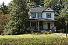
|
8516 58th Avenue | 67-022-21 | ||
| 9 | 
|
8411 58th Avenue | 67-022-10 | ||
| 10 | 
|
5617 Ruatan Street | 67-022-15 |
Geography[]
Berwyn Heights is located at 38°59′38″N 76°54′44″W / 38.99389°N 76.91222°W (38.993810, -76.912344).[14] According to the United States Census Bureau, the town has a total area of 0.69 square miles (1.79 km2), all land.[15]
Demographics[]
| Historical population | |||
|---|---|---|---|
| Census | Pop. | %± | |
| 1930 | 228 | — | |
| 1940 | 453 | 98.7% | |
| 1950 | 674 | 48.8% | |
| 1960 | 2,376 | 252.5% | |
| 1970 | 3,934 | 65.6% | |
| 1980 | 3,135 | −20.3% | |
| 1990 | 2,952 | −5.8% | |
| 2000 | 2,942 | −0.3% | |
| 2010 | 3,123 | 6.2% | |
| 2019 (est.) | 3,255 | [6] | 4.2% |
| U.S. Decennial Census[16] | |||
2010 census[]
At the 2010 census there were 3,123 people, 1,002 households, and 681 families in the town. The population density was 4,526.1 inhabitants per square mile (1,747.5/km2). There were 1,051 housing units at an average density of 1,523.2 per square mile (588.1/km2). The racial makeup of the town was 56.0% White, 15.1% African American, 0.8% Native American, 8.4% Asian, 0.1% Pacific Islander, 14.4% from other races, and 5.1% from two or more races. Hispanic or Latino of any race were 27.1%.[5]
Of the 1,002 households 34.3% had children under the age of 18 living with them, 50.1% were married couples living together, 11.0% had a female householder with no husband present, 6.9% had a male householder with no wife present, and 32.0% were non-families. 20.1% of households were one person and 7.6% were one person aged 65 or older. The average household size was 3.10 and the average family size was 3.42.
The median age in the town was 34.9 years. 21.7% of residents were under the age of 18; 12.1% were between the ages of 18 and 24; 31.1% were from 25 to 44; 24.3% were from 45 to 64; and 10.8% were 65 or older. The gender makeup of the town was 52.4% male and 47.6% female.
2000 census[]
At the 2000 census there were 2,942 people, 1,022 households, and 713 families in the town. The population density was 4,552.9 people per square mile (1,747.6/km2). There were 1,047 housing units at an average density of 1,620.3 per square mile (621.9/km2). The racial makeup of the town was 71.79% White, 12.00% African American, 0.54% Native American, 8.57% Asian, 8.23% Hispanic or Latino, 4.38% from other races, and 2.72% from two or more races.[17] of the population.
Of the 1,022 households 27.5% had children under the age of 18 living with them, 54.8% were married couples living together, 10.1% had a female householder with no husband present, and 30.2% were non-families. 19.3% of households were one person and 7.7% were one person aged 65 or older. The average household size was 2.86 and the average family size was 3.19.
The age distribution was 20.9% under the age of 18, 10.7% from 18 to 24, 33.1% from 25 to 44, 22.5% from 45 to 64, and 12.9% 65 or older. The median age was 36 years. For every 100 females, there were 103.9 males. For every 100 females age 18 and over, there were 100.2 males.
The median household income was $65,744 and the median family income was $69,013. Males had a median income of $42,525 versus $34,831 for females. The per capita income for the town was $25,793. About 0.9% of families and 5.5% of the population were below the poverty line, including 0.5% of those under age 18 and 1.6% of those age 65 or over.
Education[]
Berwyn Heights is served by the Prince George's County Public Schools:[18] Berwyn Heights Elementary School, which is located in Berwyn Heights,[19] Greenbelt Middle School (Greenbelt),[20] and Parkdale High School (Riverdale Park).[21]
Transportation[]

The only state highway providing direct access to Berwyn Heights is Maryland Route 193 (Greenbelt Road). MD 193 connects eastward to Greenbelt and westward to College Park. Just east of the town limits, MD 193 has a junction with Maryland Route 201 (Kenilworth Avenue), which provides access to Interstate 95/Interstate 495 (the Capital Beltway), D.C. Route 295 (the Kenilworth Avenue Freeway), and U.S. Route 50 (John Hanson Highway).
Government[]
The town council consists of five members, who are elected every two years on an at-large plurality voting basis, to govern the town of Berwyn Heights. The member of the council who received the most votes during the election becomes mayor. The mayor serves as the head of the government and presides at all council meetings, but in other respects is an equal member of the Council. The mayor pro tempore assumes the mayoral duties in the absence of the mayor.[22]
The current mayor is .[2] The town manager is Maria Broadbent.[23]
The town has a police department,[24] a public works department, a code enforcement department, and an administration department.
Past Mayors[]
- 1948–1952 Robert F. Burnette
- 1952–1954 Charles G. Durbin
- 1954–1956 Robert F. Burnette
- 1956–1958 John P. Wintermoyer
- 1958–1960 H. Dale Smith
- 1960–1962 Clinton D. Walker
- 1962–1966 George E. Lauterbach
- 1966–1968 Kenneth C. Styers
- 1968–1972 Harry L. Ballew
- 1972–1974 George E. Lauterbach
- 1974–1976 Jadie B. Mc Dougald, first elected mayor after change from commissioner government to mayor and council form of government.
- 1976–1978 Harry L. Ballew
- 1978–1980 Jadie B. Mc Dougald
- 1980–1982 Howard G. Wood
- 1982–1992 William T. Armistead, Jr.
- 1992–1998 Thomas J. Love
- 1998–2000 William T. Armistead, Jr.
- 2000–2001 Tawanna P. Gaines
- 2001–2002 Ronald M. Shane
- 2002–2003 Bradley S. Jewitt
- 2003–2004 Patricia D. Dennison
- 2004–2015 Cheye M. Calvo
- 2015–2016 Jodie Kulpa-Eddy
- 2016–2018 Cheryl Jewitt
- 2018 Christopher J. Rasmussen (May 9 to July 16, 2018, resigned)[25]
- 2018 Lynn White (July 16, 2018 to Dec. 6, 2018, resigned)[25]
- 2018–2020 Stephen Isler[25]
- 2020–Present [26]
Taxation[]
At 53 cents per $100 per assessed value, Berwyn Heights has one of the lower real property tax rates in Prince George's County. In 2005, the town became the first municipality in Maryland to establish a public safety taxing district, after it was authorized by the general assembly.[27] The district imposes a special tax on businesses to fund the cost of one full-time officer and helps maintain around the clock police coverage.
County government[]
Prince George's County Police Department District 1 Station in Hyattsville serves Berwyn Heights.[28]
Civic activities[]
The town also benefits from numerous town committees and organizations.[29] The town, as of October 2008, has joined a State Retirement Pension, for its employees, and police officers. This was done in order to try to compete and to retain the police officers.
Sports Park, which is the home of a Berwyn Heights civic group, is located by Indian Creek.[12]
Berwyn Heights Day is a yearly event that celebrates the founding of the town.[12]
References[]
- ^ "Berwyn Heights". Maryland Manual. Retrieved 27 June 2017.
- ^ Jump up to: a b c "Town Council". Town of Berwyn Heights. Retrieved Jan 4, 2017.
- ^ "2019 U.S. Gazetteer Files". United States Census Bureau. Retrieved July 25, 2020.
- ^ "Population Estimates". United States Census Bureau. Archived from the original on 2013-06-11. Retrieved 2013-06-26.
- ^ Jump up to: a b "U.S. Census website". United States Census Bureau. Retrieved 2013-01-25.
- ^ Jump up to: a b "Population and Housing Unit Estimates". United States Census Bureau. May 24, 2020. Retrieved May 27, 2020.
- ^ U.S. Geological Survey Geographic Names Information System: Berwyn Heights, Maryland
- ^ "Profile of General Population and Housing Characteristics: 2010 Demographic Profile Data (DP-1): Berwyn Heights town, Maryland". United States Census Bureau. Retrieved December 8, 2011.
- ^ Jump up to: a b c d Preliminary Amendment to the Historic Sites and Districts Plan. The Maryland-National Capital Park & Planning Commission. December 1990. p. 155.
- ^ Maryland's 157. Annapolis, Maryland: Maryland Municipal League. 2000. p. 39.
- ^ Maryland's 157. Annapolis, Maryland: Maryland Municipal League. 2000. p. 38.
- ^ Jump up to: a b c Maryland's 157. Annapolis, Maryland: Maryland Municipal League. 2000. p. 39.
- ^ M-NCPPC Illustrated Inventory of Historic Sites (Prince George's County, Maryland), 2006 Archived 2008-07-25 at the Wayback Machine.
- ^ "US Gazetteer files: 2010, 2000, and 1990". United States Census Bureau. 2011-02-12. Retrieved 2011-04-23.
- ^ "US Gazetteer files 2010". United States Census Bureau. Archived from the original on 2012-07-02. Retrieved 2013-01-25.
- ^ "Census of Population and Housing". Census.gov. Retrieved June 4, 2015.
- ^ "U.S. Census website". United States Census Bureau. Retrieved 2008-01-31.
- ^ "2010 CENSUS - CENSUS BLOCK MAP: Berwyn Heights town, MD."
- ^ "NEIGHBORHOOD ELEMENTARY SCHOOLS AND BOUNDARIES SCHOOL YEAR 2017-2018." Prince George's County Public Schools. Retrieved on January 31, 2018.
- ^ "NEIGHBORHOOD MIDDLE SCHOOLS AND BOUNDARIES SCHOOL YEAR 2017-2018." Prince George's County Public Schools. Retrieved on January 31, 2018.
- ^ "NEIGHBORHOOD HIGH SCHOOLS AND BOUNDARIES SCHOOL YEAR 2017-2018." Prince George's County Public Schools. Retrieved on January 31, 2018.
- ^ "About the Town Council". Berwyn Heights. Retrieved 10 May 2016.
- ^ "Town Manager". Town of Berwyn Heights, Maryland. Retrieved 17 June 2020.
- ^ "Berwyn Heights Police Department".
- ^ Jump up to: a b c "Berwyn Heights gets third mayor in less than six months". Route 1 Reporter. 2018-12-13. Retrieved 2021-04-07.
- ^ "Berwyn Heights, Prince George's County, Maryland". msa.maryland.gov. Retrieved 2019-11-01.
- ^ "Sec. 10-269. - Special Taxing Districts". Retrieved 25 October 2016.
- ^ "District 1 Station - Hyattsville. Prince George's County Police Department. Retrieved on September 9, 2018. Beat map.
- ^ "Civic Organizations". Berwyn Heights. Retrieved 10 May 2016.
External links[]
| Wikimedia Commons has media related to Berwyn Heights, Maryland. |
| Wikivoyage has a travel guide for Berwyn Heights. |
- Official website
- Town of Berwyn Heights at the Maryland State Archives
- Town of Berwyn Heights at the Wayback Machine (archive index)
- Berwyn Heights Elementary School Parent-Teacher Association (PTA) records at the University of Maryland libraries. Records of an elementary school association in Berwyn Heights.
See also[]
| show Municipalities and communities of Prince George's County, Maryland, United States |
|---|

| show Authority control |
|---|
- Berwyn Heights, Maryland
- Towns in Prince George's County, Maryland
- Towns in Maryland
- Washington metropolitan area