Aquasco, Maryland
Aquasco, Maryland | |
|---|---|
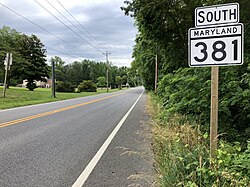 View along Aquasco Road at Croom Road in Aquasco, MD | |
 Aquasco Location within the state of Maryland | |
| Coordinates: 38°35′6″N 76°43′30″W / 38.58500°N 76.72500°WCoordinates: 38°35′6″N 76°43′30″W / 38.58500°N 76.72500°W | |
| Country | |
| State | |
| County | |
| Area | |
| • Total | 22.1 sq mi (57.3 km2) |
| • Land | 19.8 sq mi (51.3 km2) |
| • Water | 2.3 sq mi (6.0 km2) |
| Population (2010) | |
| • Total | 981 |
| • Density | 44/sq mi (17/km2) |
| Time zone | UTC−5 (Eastern (EST)) |
| • Summer (DST) | UTC−4 (EDT) |
| GNIS feature ID | 597013 |


Aquasco is an unincorporated area and census-designated place in southeastern Prince George's County, Maryland, United States, surrounding the town of Eagle Harbor and bordering Charles County.[1] As of the 2010 census, the CDP had a population of 981.[2] Aquasco was home to the Aquasco Speedway.
Geography[]
Aquasco occupies the southeastern corner of Prince George's County and is centered on the intersection of Maryland Route 381, Aquasco Road, and Maryland Route 233, Dr. Bowen Road. The Patuxent River forms the eastern boundary of the community. As of the 2010 census, the CDP had a total area of 22.1 square miles (57.3 km2), of which 19.8 square miles (51.3 km2) was land and 2.3 square miles (6.0 km2), or 10.55%, was water, consisting primarily of the Patuxent River.
The Aquasco CDP contains the Chalk Point Generating Station and surrounds the tiny incorporated town of Eagle Harbor.
History[]
Aquasco is named for a nearby tract first surveyed and patented in 1650. The name is derived from the Native American name Aquascake. Located between Swanson's Creek and the Patuxent River, the community developed as an agricultural center for the production of tobacco. The main roads connecting the widely scattered tobacco plantations were established in the 18th century and, in the early 19th century, the village of Woodville began to form. It was named after the Wood family, early settlers of Aquasco. By mid-century, the village had a grist mill, several small stores, a tavern, blacksmith, school, post office, and Methodist and Episcopal churches.[3]
Because of the number of plantations, the slave population was relatively high in this section of Prince George's County. The Freedmen's Bureau established a school at Woodville in 1867. The school later became home to . African Americans also worshiped at , established in 1848 as a mission church of St. Paul's Parish Church, which later became .[3]
Historic sites[]
The following is a list of historic sites in Aquasco identified by the Maryland-National Capital Park and Planning Commission:[3][4]
| Site Name | Image | Location | M-NCPPC Inventory Number | Comment | |
|---|---|---|---|---|---|
| 1 | 16002 Dr. Bowen Rd. | 87B-036-19 | |||
| 2 | 15701 Dr. Bowen Rd. | 87B-036-20 | |||
| 3 | 22600 Aquasco Rd. | 87B-036-14 | |||
| 4 | 19404 Aquasco Rd. | 87A-011 | |||
| 5 | 22609 Aquasco Rd. | 87B-036-16 | |||
| 6 | 22919 Christ Church Road | 87B-33 | Historic church demolished. | ||
| 7 | 22200 Saint Mary's Church Rd. | 87B-036-37 | |||
| 8 | St. Mary's Rectory | 
|
16305 Saint Mary's Church Rd. | 87B-036-08 | Listed on the National Register of Historic Places, September 10, 1987 |
| 9 | 16100 St. Phillip's Church Road | 87B-36-12 | Historic church destroyed by fire in 1976. | ||
| 10 | Sunnyside | 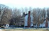
|
16005 Dr. Bowen Rd. | 87B-036-21 | Listed on the National Register of Historic Places, May 29, 1987 |
| 11 | 20218 Aquasco Rd. | 87A-022 | |||
| 12 | 16410 St. Mary’s Church Road | 87B-036-05 | |||
| 13 | Villa DeSales | 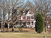
|
22410 Aquasco Rd. | 87B-036-13 | Listed on the National Register of Historic Places, July 14, 1988 |
| 14 | 17109 Milltown Landing Road | 87A-019 | |||
| 15 | 22606 Aquasco Rd. | 87B-036-15 | |||
| 16 | 21500 Aquasco Road | 87B-34 |
Government[]
Prince George's County Police Department District 5 Station in Clinton CDP serves the community.[5]
The U.S. Postal Service operates the Aquasco Post Office.[6]
Education[]
Aquasco residents are assigned to schools in Prince George's County Public Schools.[7]
Residential areas of the CDP area are zoned to Baden Elementary School,[8] Gwynn Park Middle School,[9] and Gwynn Park High School.[10]
References[]
- ^ U.S. Geological Survey Geographic Names Information System: Aquasco, Maryland
- ^ "Profile of General Population and Housing Characteristics: 2010 Demographic Profile Data (DP-1): Aquasco CDP, Maryland". United States Census Bureau. Retrieved December 15, 2011.
- ^ a b c M-NCPPC African-American Heritage Survey, October 1996: Properties Within or Closely Associated With Historic Communities (Prince George's County, Maryland), 1996[permanent dead link].
- ^ M-NCPPC Illustrated Inventory of Historic Sites (Prince George's County, Maryland), 2006.
- ^ "District 5 Station - Clinton." Prince George's County Police Department. Retrieved on September 9, 2018. " 6707 Groveton Drive Clinton, MD 20735". Beat map. See 2010 U.S. Census index map of Clinton CDP: area with police station is on the edge of page 6 with surroundings on page 5.
- ^ "AQUASCO." U.S. Postal Service. Retrieved on September 11, 2018. "22503 AQUASCO RD AQUASCO, MD 20608-9998"
- ^ "2010 CENSUS - CENSUS BLOCK MAP (INDEX): Aquasco CDP, MD." U.S. Census Bureau. Retrieved on September 2, 2018. Pages: 1, 2, 3, 4, and 5.
- ^ "NEIGHBORHOOD ELEMENTARY SCHOOLS AND BOUNDARIES SCHOOL YEAR 2018-2019." Prince George's County Public Schools. Retrieved on September 2, 2018.
- ^ "NEIGHBORHOOD MIDDLE SCHOOLS AND BOUNDARIES SCHOOL YEAR 2018-2019." Prince George's County Public Schools. Retrieved on September 2, 2018.
- ^ "NEIGHBORHOOD HIGH SCHOOLS AND BOUNDARIES SCHOOL YEAR 2018-2019." Prince George's County Public Schools. Retrieved on September 2, 2018.
External links[]
- Villa de Alpacas Farm at Historic Villa De Sales circa 1877, Aquasco, MD
- St. Dominic Catholic Mission Church circa 1879, Aquasco, MD
- Detailed history of St. Dominic Catholic Church in Aquasco, MD
- History of the Aquasco Speedway, 1955

- Census-designated places in Maryland
- Census-designated places in Prince George's County, Maryland