Maui County, Hawaii
Maui County | |
|---|---|
U.S. county | |
 Haleakalā National Park | |
 Flag  Seal | |
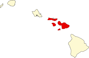 Location within the U.S. state of Hawaii | |
 Hawaii's location within the U.S. | |
| Coordinates: 20°53′00″N 156°39′00″W / 20.883333333333°N 156.65°W | |
| Country | |
| State | |
| Founded | 1905 |
| Seat | Wailuku |
| Largest city | Kahului |
| Government | |
| • Mayor | Mike Victorino |
| Area | |
| • Total | 2,398 sq mi (6,210 km2) |
| • Land | 1,162 sq mi (3,010 km2) |
| • Water | 1,237 sq mi (3,200 km2) 51.6%% |
| Population | |
| • Estimate (2019) | 167,417 |
| • Density | 133/sq mi (51/km2) |
| Time zone | UTC−10 (Hawaii–Aleutian) |
| • Summer (DST) | HADT |
| Congressional district | 2nd |
| Website | www |

Maui County, officially the County of Maui, is a county in the U.S. state of Hawaii. It consists of the islands of Maui, Lānaʻi, Molokaʻi (except for a portion of Molokaʻi that comprises Kalawao County), Kahoʻolawe, and Molokini. The latter two are uninhabited. As of the 2010 census, the population was 154,834.[1] The county seat is Wailuku.[2]
Maui County is included in the Kahului-Wailuku-Lahaina, HI Metropolitan Statistical Area.
Government[]
Maui County has a quasi-mayor-council form of municipal government. Unlike traditional municipal governments, the county government is established by the state legislature by statute and is not chartered. Executive authority is vested in the mayor, elected by the voters on a nonpartisan basis to a four-year term (with a limit of two consecutive full terms). Legislative authority is vested in the nine-member county council. All seats in the county council have residency requirements, but all Maui County voters may vote in elections for all nine seats regardless of residence. Members of the county council are elected on a nonpartisan basis to two-year terms (with a limit of five consecutive full terms).
The mayor of Maui County is Mike Victorino, serving since January 2, 2019. Victorino was a member of the county council from 2007 to 2017.
The county's Department of Liquor Control regulates and enforces state and county laws regarding the manufacture, importation, sale and consumption of intoxicating liquors.
Geography[]
According to the U.S. Census Bureau, the county has a total area of 2,398 square miles (6,210 km2), of which 1,162 square miles (3,010 km2) is land and 1,237 square miles (3,200 km2) (51.6%) is water.[3] The islands that comprise Maui County correspond to the remnants of the ancient landmass of Maui Nui. The highest point in the county is the peak of Haleakalā at 10,023 feet (3,055 m). Haleakalā is a shield volcano located on the eastern side of the island of Maui.
Adjacent counties[]
- Hawaiʻi County, Hawaii - southeast
- Kalawao County, Hawaii - north
- Honolulu County, Hawaii - northwest
National protected areas[]
- Haleakalā National Park
- Kakahaiʻa National Wildlife Refuge
- Kealia Pond National Wildlife Refuge
Demographics[]
| Historical population | |||
|---|---|---|---|
| Census | Pop. | %± | |
| 1900 | 26,743 | — | |
| 1910 | 29,762 | 11.3% | |
| 1920 | 37,385 | 25.6% | |
| 1930 | 55,541 | 48.6% | |
| 1940 | 55,534 | 0.0% | |
| 1950 | 48,179 | −13.2% | |
| 1960 | 42,576 | −11.6% | |
| 1970 | 45,984 | 8.0% | |
| 1980 | 70,847 | 54.1% | |
| 1990 | 100,374 | 41.7% | |
| 2000 | 128,094 | 27.6% | |
| 2010 | 154,834 | 20.9% | |
| 2019 (est.) | 167,417 | [4] | 8.1% |
| U.S. Decennial Census[5] 1790-1960[6] 1900-1990[7] 1990-2000[8] 2010-2018[1] | |||
As of the 2000 Census,[9] there were 128,094 people, 43,507 households, and 29,889 families residing in the county. The population density was 110 people per square mile (43/km2). There were 56,377 housing units at an average density of 49 per square mile (19/km2). The racial makeup of the county was 33.01% Asian, 28.90% White, 22.24% from two or more races, 10.72% Pacific Islander, 1.40% Black or African American, 0.37% Native American and 1.36% from other races. 7.8% of the population were Hispanic or Latino of any race.
There were 43,507 households, out of which 33.00% had children under the age of 18 living with them, 50.90% were married couples living together, 12.00% had a female householder with no husband present, and 31.30% were non-families. 21.90% of all households were made up of individuals, and 6.30% had someone living alone who was 65 years of age or older. The average household size was 2.91 and the average family size was 3.41.
In the county, the population was spread out, with 25.50% under the age of 18, 7.70% from 18 to 24, 30.90% from 25 to 44, 24.40% from 45 to 64, and 11.40% who were 65 years of age or older. The median age was 37 years. For every 100 females, there were 100.90 males. For every 100 females age 18 and over, there were 100.20 males.
Economy[]
Top employers[]
According to the county's 2018 Comprehensive Annual Financial Report,[10] the top employers in the county are:
| # | Employer | # of Employees |
|---|---|---|
| 1 | State of Hawaii | 4,860 |
| 2 | Maui County | 2,423 |
| 3 | Grand Wailea Resort & Spa | 1,400 |
| 4 | Ritz-Carlton-Kapalua | 1,000 |
| 5 | United States Federal Government | 860 |
| 6 | Maui Memorial Medical Center | 800 |
| Four Seasons Resort Maui | ||
| 7 | Fairmont Kea Lani | 700 |
| Four Seasons Lānaʻi | ||
| Westin Maui Resort & Spa Ka'anapali | ||
| 8 | Kea Lani Maui Restaurant | 600 |
| 9 | Hale Makua Health Service | 500 |
| Kaanapali Beach Club | ||
| Montage Kapalua Bay | ||
| Walmart | ||
| Royal Lahaina Resort | ||
| 10 | Wailea Beach Resort Marriott | 420 |
Transportation[]
Airports[]
Three airports provide air service to the island of Maui:
- Hana Airport provides regional service to eastern Maui
- Kahului Airport in central Maui is the island's busiest airport
- Kapalua Airport provides regional service to western Maui
There are also airports on Maui's smaller adjacent islands:
- Lānaʻi Airport provides regional service to Lānaʻi
- Molokai Airport provides regional service to Molokaʻi
Major highways[]
 Route 30
 Route 31
 Route 32
 Route 36
 Route 37
 Route 44
 Route 310
 Route 311

 Route 340
 Route 377
 Route 378
 Route 380
 Route 440
 Route 450
 Route 460
 Route 465
 Route 470
 Route 480
 Route 3000
Communities[]
Census-designated places[]
Unincorporated communities[]
Former communities[]
Politics[]
Maui County was the only county in the United States won by Dennis Kucinich during his unsuccessful campaign for the Democratic Party nomination to the presidency in 2004.[12]
Sister cities[]
Maui County's sister cities are:[13]
 American Samoa
 Arequipa, Peru
 Bacarra, Philippines
- Badoc, Philippines
- Cabugao, Philippines
 Easter Island, Chile
 Embo, Scotland, United Kingdom
 Fukuyama, Japan
 Funchal, Portugal
 Goyang, South Korea
- Hachijō, Japan
- Manila, Philippines
 Pingtung, Taiwan
- Puerto Princesa, Philippines
- Quezon City, Philippines
 Saipan, Northern Mariana Islands
- San Juan, Philippines
- Santa, Philippines
 Sanya, China
- São Miguel Island, Portugal
- Sarrat, Philippines
- Zambales, Philippines
See also[]
- Maui
- Kula
- Vic-Maui Yacht Race
References[]
- ^ Jump up to: a b "State & County QuickFacts". United States Census Bureau. Archived from the original on July 13, 2011. Retrieved June 28, 2014.
- ^ "Find a County". National Association of Counties. Retrieved June 7, 2011.
- ^ "US Gazetteer files: 2010, 2000, and 1990". United States Census Bureau. 2011-02-12. Retrieved 2011-04-23.
- ^ "Population and Housing Unit Estimates". Retrieved May 9, 2019.
- ^ "U.S. Decennial Census". United States Census Bureau. Retrieved June 28, 2014.
- ^ "Historical Census Browser". University of Virginia Library. Retrieved June 28, 2014.
- ^ "Population of Counties by Decennial Census: 1900 to 1990". United States Census Bureau. Retrieved June 28, 2014.
- ^ "Census 2000 PHC-T-4. Ranking Tables for Counties: 1990 and 2000" (PDF). United States Census Bureau. Retrieved June 28, 2014.
- ^ "U.S. Census website". United States Census Bureau. Retrieved 2008-01-31.
- ^ "County of Maui CAFR". Archived from the original on February 27, 2019.
- ^ Leip, David. "Dave Leip's Atlas of U.S. Presidential Elections". uselectionatlas.org. Retrieved May 26, 2017.
- ^ "US Election Atlas". Dave Leip. Retrieved 2008-01-11.
- ^ "County of Hawai'i Official Sister Cities". hawaiicounty.gov. County of Maui. Archived from the original on 2021-04-27. Retrieved 2021-04-27.
External links[]
 Media related to Maui County, Hawaii at Wikimedia Commons
 Maui County, Hawaii travel guide from Wikivoyage
- Official Maui County website
| show Places adjacent to Maui County, Hawaii |
|---|
| show Islands, municipalities, and communities of Maui County, Hawaii, United States |
|---|

| show |
|---|
| show Authority control |
|---|
- Hawaii counties
- Maui County, Hawaii
- 1905 establishments in Hawaii
- Populated places established in 1905