McAlevys Fort, Pennsylvania
McAlevys Fort, Pennsylvania | |
|---|---|
 The Stone Creek Valley Fire Department on PA 26 in McAlevys Fort. | |
 McAlevys Fort | |
| Coordinates: 40°38′23″N 77°49′53″W / 40.63972°N 77.83139°WCoordinates: 40°38′23″N 77°49′53″W / 40.63972°N 77.83139°W | |
| Country | United States |
| State | Pennsylvania |
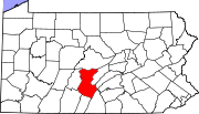
| County | Huntingdon |
| Township | Jackson |
| Elevation | 748 ft (228 m) |
| Time zone | UTC-5 (Eastern (EST)) |
| • Summer (DST) | UTC-4 (EDT) |
| GNIS feature ID | 1180598[1] |
McAlevys Fort is an unincorporated community located Jackson Townshipp in Huntingdon County, Pennsylvania, United States. The community is located along Pennsylvania Route 26 north of the overlap with Pennsylvania Route 305.
The community was named after a pioneer fort which was built near the present town site in 1778 by Captain William McAlevy.[2]
References[]
- ^ "McAlevys Fort, Pennsylvania". Geographic Names Information System. United States Geological Survey.
- ^ Espenshade, Abraham Howry (1925). Pennsylvania Place Names. Evangelical Press. p. 312. ISBN 978-0-8063-0416-8.
Categories:
- Unincorporated communities in Huntingdon County, Pennsylvania
- Unincorporated communities in Pennsylvania
- Pennsylvania geography stubs


