McClure, Illinois
McClure, Illinois | |
|---|---|
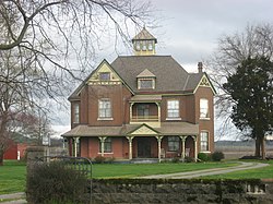 Thomas J. and Caroline McClure House, a historic site in the village | |
 Location of McClure in Illinois | |
 Location of Illinois in the United States | |
| Coordinates: 37°19′04″N 89°25′53″W / 37.31778°N 89.43139°WCoordinates: 37°19′04″N 89°25′53″W / 37.31778°N 89.43139°W | |
| Country | United States |
| State | Illinois |
| County | Alexander |
| Area | |
| • Total | 1.53 sq mi (3.96 km2) |
| • Land | 1.53 sq mi (3.96 km2) |
| • Water | 0.00 sq mi (0.00 km2) 0% |
| Population (2010) | |
| • Total | 402 |
| • Estimate (2019)[2] | 301 |
| • Density | 196.99/sq mi (76.06/km2) |
| Time zone | UTC-6 (CST) |
| • Summer (DST) | UTC-5 (CDT) |
| ZIP Code(s) | 62957[3] |
| Area code(s) | 618 |
| FIPS code | 17-45525 |
| Wikimedia Commons | McClure, Illinois |

McClure is a village in , Alexander County, Illinois, United States. It was incorporated in 2004[4] and had a population of 402 at the 2010 census.[5]
McClure is part of the Cape Girardeau–Jackson Metropolitan Statistical Area.
Geography[]
According to the 2010 census, McClure has a total area of 1.53 square miles (3.96 km2), all land.[6]
History[]
The community of McClure was established prior to 1836, the year its post office opened, and was originally known as Clear Creek Landing or Clear Creek. The community's name was changed to Wheatland in 1887 due to the large wheat fields in the region. Thomas J. McClure, for whose family the village was eventually named, moved to the village in 1842; he and his wife Caroline became prominent local farmers and raised seven children. Their son J. T. became the village postmaster, and he had the post office's name changed to McClure in 1895 to avoid confusion with the Wheaton, Illinois post office. By the 1930s, the village had two train stations, a sizable business district, and a population of roughly 400. The village has since declined and now has relatively few businesses.[7]
The McClure family's house has been listed on the National Register of Historic Places.[8]
Demographics[]
| Historical population | |||
|---|---|---|---|
| Census | Pop. | %± | |
| 2010 | 402 | — | |
| 2019 (est.) | 301 | [2] | −25.1% |
| U.S. Decennial Census[9] | |||
References[]
- ^ "2019 U.S. Gazetteer Files". United States Census Bureau. Retrieved July 14, 2020.
- ^ a b "Population and Housing Unit Estimates". United States Census Bureau. May 24, 2020. Retrieved May 27, 2020.
- ^ "ZIP Code™ Lookup". USPS.com. United States Postal Service. Retrieved December 27, 2020.
- ^ "Boundary Changes". Geographic Change Notes: Illinois. Population Division, United States Census Bureau. 2006-05-19. Archived from the original on 2006-02-06. Retrieved 2008-05-30.
- ^ "Geographic Identifiers: 2010 Demographic Profile Data (G001): McClure village, Illinois". U.S. Census Bureau, American Factfinder. Archived from the original on February 12, 2020. Retrieved May 8, 2013.
- ^ "G001 - Geographic Identifiers - 2010 Census Summary File 1". United States Census Bureau. Archived from the original on 2020-02-13. Retrieved 2015-10-26.
- ^ Webb, Brenda M. (July 1, 1996). "National Register of Historic Places Registration Form: Thomas J. and Caroline McClure House" (PDF). National Park Service. Archived from the original (PDF) on January 16, 2014. Retrieved January 16, 2014.
- ^ "National Register Information System". National Register of Historic Places. National Park Service. July 9, 2010.
- ^ "Census of Population and Housing". Census.gov. Retrieved June 4, 2015.
Municipalities and communities of Alexander County, Illinois, United States | ||
|---|---|---|
| City | ||
| Villages | ||
| Precincts | ||
| CDPs | ||
| Other communities | ||
| Ghost town | ||
| ||
This Alexander County, Illinois location article is a stub. You can help Wikipedia by . |
- Villages in Illinois
- Villages in Alexander County, Illinois
- Cape Girardeau–Jackson metropolitan area
- 1836 establishments in Illinois
- Southern Illinois geography stubs