Miami, Oklahoma
Miami, Oklahoma | |
|---|---|
City | |
 Downtown Miami (2008) | |
 Location within Ottawa County and Oklahoma | |
| Coordinates: 36°53′1″N 94°52′34″W / 36.88361°N 94.87611°WCoordinates: 36°53′1″N 94°52′34″W / 36.88361°N 94.87611°W[1] | |
| Country | United States |
| State | Oklahoma |
| County | Ottawa |
| Government | |
| • Mayor | Bless Parker (R) |
| Area | |
| • Total | 10.92 sq mi (28.29 km2) |
| • Land | 10.84 sq mi (28.07 km2) |
| • Water | 0.09 sq mi (0.22 km2) |
| Elevation | 797 ft (243 m) |
| Population (2010) | |
| • Total | 13,570 |
| • Estimate (2019)[3] | 13,088 |
| • Density | 1,207.60/sq mi (466.25/km2) |
| Time zone | UTC-6 (CST) |
| • Summer (DST) | UTC-5 (CDT) |
| ZIP code | 74354-74355 |
| Area code | 539/918 |
| FIPS code | 40-48000[1] |
| GNIS feature ID | 1095343[1] |
| Website | Miami, Oklahoma |

Miami (/maɪˈæmə/ my-AM-ə)[4][5][6] is a city in and county seat of Ottawa County, Oklahoma, United States, founded in 1891.[1] Lead and zinc mining established by 1918, caused it to boom.
It is the capital of the Miami Tribe of Oklahoma, after which it is named, the Modoc Tribe of Oklahoma, the Ottawa Tribe of Oklahoma, the Peoria Tribe of Indians and the Shawnee Tribe. As of the 2010 census, the city had 13,570 inhabitants, a one percent decline since 2000.
History[]
Miami began in an unusual way, compared to other towns in Indian Territory. Per the Encyclopedia of Oklahoma History and Culture "... it was settled in a business-like way by men of vision who looked into the future and saw possibilities. It didn't just grow. It was carefully planned."[7]
W. C. Lykins petitioned the U.S. Congress to pass legislation on March 3, 1891, to establish the town. He met with Thomas F. Richardville, chief of the Miami Tribe of Oklahoma, who agreed to meet in turn with the U.S. Indian Commission and the Ottawa Tribe.
That meeting resulted in Congress authorizing the secretary of the United States Department of the Interior to approve the townsite purchase from the Ottawas. Lykins, Richardville and Manford Pooler, chief of the Ottawa, are identified in historical accounts as "fathers of Miami." Lykins' company, the Miami Town Company, bought 588 acres (238 ha) of land from the Ottawa for ten dollars an acre. On June 25–26, 1891 they held an auction of lots. In 1895, Miami incorporated and had more than 800 residents.[7]
The discovery of rich deposits of lead and zinc under Quapaw land a few miles north caused Miami to boom. In 1907, at the time of statehood, its population was 1,893, which increased as mining was established to 6,802 by 1920.[7]
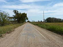
Miami was on the route of the Jefferson Highway established in 1915, with that road running more than 2,300 miles (3,700 km) from Winnipeg, Manitoba to New Orleans, Louisiana.[8] It was later on Route 66, and still has an historic Original Nine-Foot Section of Route 66 Roadbed.
It is the capital of the Miami Tribe of Oklahoma, after which it is named, the Modoc Tribe of Oklahoma, Ottawa Tribe of Oklahoma, Peoria Tribe of Indians and Shawnee Tribe.[9]
Geography[]
Miami is located near 36°53′1″N 94°52′34″W / 36.88361°N 94.87611°W (36.883539, −94.876018).[1] According to the United States Census Bureau, the city has a total area of 9.8 square miles (25 km2), of which 9.7 square miles (25 km2) is land and 0.1 square miles (0.26 km2) (0.82%) is water.
Flooding[]
Miami is located on the Neosho River, and was impacted by the Great Flood of 1951. The town has flooded more than two dozen times since the 1990s, most recently during the 2019 Arkansas River floods.[10][11][12] Town residents and neighboring Native American groups have objected to maintaining high water levels on the river at Pensacola Dam and its popular vacation area, Grand Lake, on the grounds that when water backs up downstream, it can increase Miami's flooding problems.[11][13][14]
Demographics[]
| Historical population | |||
|---|---|---|---|
| Census | Pop. | %± | |
| 1900 | 1,527 | — | |
| 1910 | 2,907 | 90.4% | |
| 1920 | 6,802 | 134.0% | |
| 1930 | 8,064 | 18.6% | |
| 1940 | 8,345 | 3.5% | |
| 1950 | 11,801 | 41.4% | |
| 1960 | 12,869 | 9.1% | |
| 1970 | 13,880 | 7.9% | |
| 1980 | 14,237 | 2.6% | |
| 1990 | 13,142 | −7.7% | |
| 2000 | 13,704 | 4.3% | |
| 2010 | 13,570 | −1.0% | |
| 2019 (est.) | 13,088 | [3] | −3.6% |
| Sources:[15][16][17][18][19][20] | |||
As of the 2010 census, there were 13,570 people, 5,315 households, and 3,337 families residing in the city.[21] a one percent decline from 13,704 at the 2000 census.[22] The population density was 1,258.7 people per square mile (485.9/km2).[21] The racial makeup of the city was 68.9% white, 1.3% African American, 17.1% Native American, 0.5% Asian, 2% Pacific Islander, 2.1% from other races, and 8% from two or more races.[21] Hispanic or Latino of any race made up 4.8% of the population.[21]
There were 5,315 households, out of which 31.9% had children under the age of 18 living with them, 44.6% were married couples living together, 15% had a female householder with no husband present, and 36.2% were non-families.[23] Single individuals living alone accounted for 31.9% of households and individuals 65 years of age or older living alone accounted for 14.7% of households.[23] The average household size was 2.46 and the average family size was 3.07.[23]
In the city, the population was spread out, with 24.7% under the age of 18, 57.1% from 18 to 64, and 18.2% who were 65 years of age or older.[23] The median age was 35.8 years.[23] The population was 53.2% female and 46.8% male.[23]
The median income for a household in the city was $34,561, and the median income for a family was $42,313.[23] Males had a median income of $32,699 versus $25,320 for females.[23] About 14.2% of families and 19.2% of the population were below the poverty line.[23]
In 2020, about one in four residents lived in poverty.[11]
Government[]
Local government in Miami consists of a Mayor and four councilmen representing four Wards.
- Mayor – Bless Parker
- Ward One Councilman – David Davis
- Ward Two Councilman – Doug Weston
- Ward Three Councilman – Ryan Orcutt[24]
- Ward Four Councilman – Vicki Lewis[24]
As of 2015, the city is represented in the Oklahoma House of Representatives by Democrat Ben Loring,[25] and in the Oklahoma Senate by Republican Micheal Bergstrom. The city lies within Oklahoma's 2nd congressional district, represented by Markwayne Mullin since 2013.
Transportation[]
Miami is on Interstate 44 and U.S. Route 69,[26] and is approximately two miles (3.2 km) from U.S. Route 59.[27]
Pelivan Transit, owned and operated by Grand Gateway EDA & Northeast Oklahoma Tribal Transit Consortium, provides a trolley loop in Miami, as well as certain on-demand bus services.[28]
Miami is served by Miami Regional Airport (KMIO; FAA Identifier MIO), with a 5,020-foot (1,530 m) paved runway.[29] Commercial air transportation is available from Joplin Regional Airport,[30] about 34 miles (55 km) northeast,[31] or Tulsa International Airport,[32] about 85 miles (137 km) southwest.[33]
Coleman Theatre and historical buildings[]
Miami and Ottawa County, together with nearby Delaware County to the south, have a large impact on tourism in Oklahoma. These counties combined are the third-largest tourism destination in the state, following only the Oklahoma City and Tulsa metropolitan areas.[34]
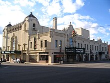
Miami is home to the historic Coleman Theatre, located at 103 N. Main St. On April 18, 1929, the 1,600-seat Coleman Theatre enjoyed a grand opening. Designed by the Boller Bros., and built by George L. Coleman Sr. at a cost of $600,000, the Louis XV interior includes gold leaf trim, silk damask panels, stained glass panels, marble accents, a carved mahogany staircase, Wurlitzer pipe organ, decorative plaster moldings, and bronze railings. In 1983, the Coleman Theatre was placed on the National Register of Historical Places for Ottawa County. A local non-profit community group established in 1959 the Miami Little Theatre, which performs five large-scale productions on the Coleman stage every year.
Other Miami structures are also listed on the National Register of Historical Places for Ottawa County, including the George L. Coleman Sr. House, the Miami Marathon Oil Company Service Station, and the Miami Downtown Historic District.
Education[]
Public schools serving most of Miami are managed by the Miami Public Schools school district.[35] The high school is Miami High School, whose mascot is the Wardog. The Wardog is a mascot unique to Miami and has not been adopted as a mascot by any other school in the United States.[36]
A portion of northern Miami is instead within the Commerce Public Schools school district.[37]
Northeastern Oklahoma A&M College initially was accredited in 1925 by the North Central Association of Colleges and Schools. It is a two-year community college with about 2,000 students.[38]
Notable people[]
- Keith Anderson – musician
- David Froman – actor[39]
- Cassie Gaines – singer
- Steve Gaines – musician
- Carol Littleton – film editor
- Mackenzie McKee - reality TV personality
- Charles R. Nesbitt – public servant
- Steve Owens – 1969 Heisman Trophy winner
- Moriss Taylor – singer/TV host
- Charles Banks Wilson – artist
- Glad Robinson Youse - composer
Gallery[]

Interior of the Coleman Theatre

Clock and bench in downtown Miami
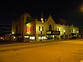
Coleman Theatre in downtown Miami at night

Original Wurlitzer organ in the Coleman Theatre
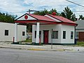
Former Miami Marathon Oil Company service station. Building was last used as a salon.


See also[]
- Miami Original Nine-Foot Section of Route 66 Roadbed
References[]
- ^ Jump up to: a b c d e f "GNIS Detail - Miami". geonames.usgs.gov. Retrieved April 9, 2018.
- ^ "2019 U.S. Gazetteer Files". United States Census Bureau. Retrieved July 28, 2020.
- ^ Jump up to: a b "Population and Housing Unit Estimates". United States Census Bureau. May 24, 2020. Retrieved May 27, 2020.
- ^ "Facts for Kids: Miami Indians (Miamis)". bigorrin.org. Retrieved April 9, 2018.
- ^ "Indian History at Hicksville-Ohio.com". hicksville-ohio.com. Archived from the original on January 23, 2018. Retrieved April 9, 2018.
- ^ "FAQ". Archived from the original on May 9, 2008. Retrieved December 7, 2008.
- ^ Jump up to: a b c Heck, Jess. "Miami". Encyclopedia of Oklahoma History and Culture. Retrieved April 8, 2021.
- ^ "The Jefferson Highway Route in Oklahoma". Oklahoma Members of the Jefferson Highway Association. Retrieved October 27, 2019.
- ^ "Oklahoma Indian Nations Pocket Pictorial". Oklahoma Indian Affairs Commission. 2008. Archived from the original on February 11, 2009.
- ^ Stogsdill, Sheila (May 25, 2019). "Miami police crack down on road barricade violations while residents go into 'survival mode' amid unrelenting flooding". Tulsa World. Retrieved February 18, 2020.
- ^ Jump up to: a b c Mervosh, Sarah (August 27, 2019). "A Senator's Lake House vs. a Town Fighting Flooding". The New York Times. ISSN 0362-4331. Retrieved February 18, 2020.
- ^ "2007 Miami Flooding Slide Show". The Joplin Globe. July 2, 2007. Retrieved February 18, 2020.
- ^ Ellis, Jim (September 9, 2019). "Miami leaders call Inhofe amendment 'unfair'". The Journal Record. Retrieved February 18, 2020.
- ^ "Miami, Oklahoma residents voice concerns with proposal to increase Grand Lake's level by two feet". KOAM-TV. February 12, 2020. Retrieved February 18, 2020.
- ^ "Population-Oklahoma" (PDF). U.S. Census 1910. U.S. Census Bureau. p. 161. Retrieved November 22, 2013.
- ^ "Population-Oklahoma" (PDF). 15th Census of the United States. U.S. Census Bureau. Retrieved November 27, 2013.
- ^ "Number of Inhabitants: Oklahoma" (PDF). 18th Census of the United States. U.S. Census Bureau. Retrieved November 22, 2013.[permanent dead link]
- ^ "Oklahoma: Population and Housing Unit Counts" (PDF). U.S. Census Bureau. Retrieved November 22, 2013.
- ^ "U.S. Census website". United States Census Bureau. Retrieved January 31, 2008.
- ^ "Incorporated Places and Minor Civil Divisions Datasets: Subcounty Population Estimates: April 1, 2010 to July 1, 2012". U.S. Census Bureau. Archived from the original on June 11, 2013. Retrieved November 25, 2013.
- ^ Jump up to: a b c d United States Census Demographic Profile of Miami, Oklahoma, at U.S. Census website (cite does not allow direct link). (accessed September 5, 2013)
- ^ CensusViewer:Miami, Oklahoma Population. Retrieved October 21, 2013.
- ^ Jump up to: a b c d e f g h i 2007–2011 American Community Survey 5-Year Estimates for Miami, Oklahoma, at U.S. Census website (cite does not allow direct link). (accessed September 5, 2013)
- ^ Jump up to: a b "City Council / Mayor". miamiokla.net. Retrieved October 7, 2018.
- ^ "Representative Ben Loring-Oklahoma House of Representatives". Oklahoma State Legislature. Archived from the original on October 28, 2015.
- ^ "Miami, Oklahoma". Google Maps. Retrieved September 3, 2020.
- ^ "Miami, Oklahoma to One Stop Convenience Store". Google Maps. Retrieved September 3, 2020.
- ^ "Welcome to Pelivan Transit". Pelivan Transit. Retrieved September 3, 2020.
- ^ "Miami Regional Airport". AirNav.com. Retrieved September 3, 2020.
- ^ "Joplin Regional Airport". Joplin, Missouri. Retrieved September 3, 2020.
- ^ "Joplin Regional Airport to Miami, Oklahoma". Google Maps. Retrieved September 3, 2020.
- ^ "Tulsa International Airport". TulsaAirports.com. Retrieved September 3, 2020.
- ^ "Tulsa International Airport to Miami, Oklahoma". Google Maps. Retrieved September 3, 2020.
- ^ Hutson-Miller, Kaylea M. (October 19, 2019). "Ottawa, Delaware counties generates $519 million combined in visitor spending as 'welcome mat' for Oklahoma". Tulsa World. Retrieved October 19, 2019.
- ^ "Miami Public Schools - Miami High School". miami.k12.ok.us. Archived from the original on April 10, 2018. Retrieved April 9, 2018.
- ^ "History of the Wardog". wardogathletics.com. Retrieved July 11, 2018.
- ^ "SCHOOL DISTRICT REFERENCE MAP (2010 CENSUS): Ottawa County, OK" (PDF). U.S. Census Bureau. Retrieved March 29, 2021. – Compare to the highway map.
- ^ "Northeastern A&M College home page". neo.edu. Archived from the original on February 2, 2015. Retrieved April 9, 2018.
- ^ "Miami Little Theatre". Retrieved February 10, 2010.
External links[]
| Wikimedia Commons has media related to Miami, Oklahoma. |
| Wikivoyage has a travel guide for Miami, Oklahoma. |
- City of Miami
- Miami Little Theatre
- City of Miami Economic Development Department[permanent dead link]
- The Miami News-Record
- Miami Public Schools
- A Tour of the Historic Coleman Theater in Miami, Oklahoma
| show Municipalities and communities of Ottawa County, Oklahoma, United States |
|---|

| show Authority control |
|---|
- Cities in Oklahoma
- Cities in Ottawa County, Oklahoma
- County seats in Oklahoma
- Micropolitan areas of Oklahoma
- 1891 establishments in Oklahoma Territory
- Populated places established in 1891