Miloslavov
Miloslavov | |
|---|---|
Municipality | |
 Church in Miloslavov | |
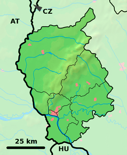
 Miloslavov Location of Miloslavov in the Bratislava Region | |
| Coordinates: 48°06′N 17°18′E / 48.100°N 17.300°ECoordinates: 48°06′N 17°18′E / 48.100°N 17.300°E | |
| Country | Slovakia |
| Region | Bratislava |
| District | Senec |
| Area | |
| • Total | 10.194 km2 (3.936 sq mi) |
| Elevation | 129 m (423 ft) |
| Population (2019) | |
| • Total | 3,016 |
| • Density | 300/km2 (770/sq mi) |
| Postal code | 900 42 (pošta Dunajská Lužná) |
| Area code(s) | 421-2 |
| Car plate | SC |
| Website | www.miloslavov.sk |
Miloslavov (Hungarian: Annamajor) is a village and municipality in western Slovakia in Senec District in the Bratislava Region.
History[]
In historical records the village was first mentioned in 1332–1337.
Geography[]
The municipality lies at an altitude of 129 metres and covers an area of 10.194 km². It consists of two parts. Miloslava and Alžbetin Dvor. Both are now under heavy real estate investment which is happening now all around Bratislava.
Demographics[]
According to the 2011 census, the municipality had 1,780 inhabitants. 1,589 of inhabitants were Slovaks, 47 Hungarians, 12 Czechs and 132 others and unspecified.[1]
References[]
- ^ "Archived copy" (PDF). Archived from the original (PDF) on 2012-11-14. Retrieved 2012-11-14.
{{cite web}}: CS1 maint: archived copy as title (link)
External links/Sources[]
![]() Media related to Miloslavov at Wikimedia Commons
Media related to Miloslavov at Wikimedia Commons
- Miloslavov - Webpage of Miloslavov
- https://web.archive.org/web/20070513023228/http://www.statistics.sk/mosmis/eng/run.html
Categories:
- Villages and municipalities in Senec District
- Bratislava Region geography stubs

