Most pri Bratislave
This article needs additional citations for verification. (February 2013) |
Most pri Bratislave | |
|---|---|
Municipality | |
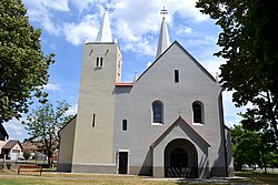 Church of the Sacred Heart | |
 Most pri Bratislave Location of Most pri Bratislave in the Bratislava Region | |
| Coordinates: 48°08′27″N 17°16′10″E / 48.14083°N 17.26944°ECoordinates: 48°08′27″N 17°16′10″E / 48.14083°N 17.26944°E | |
| Country | Slovakia |
| Region | Bratislava |
| District | Senec |
| First mentioned | 1283 |
| Area | |
| • Total | 19.01 km2 (7.34 sq mi) |
| Elevation | 130 m (430 ft) |
| Population (2011) | |
| • Total | 2,144 |
| • Density | 110/km2 (290/sq mi) |
| Postal code | 900 32 |
| Area code(s) | 421-2 |
| Car plate | SC |
| Website | www.mostpribratislave.sk |


Most pri Bratislave (Hungarian: Dunahidas, German: Bruck) is a village and municipality in western Slovakia in Senec District in the Bratislava Region.
History[]
In historical records the village was first mentioned in 1283. Until their expulsion in 1945 the village was inhabited by Germans.
Geography[]
The municipality lies at an altitude of 130 metres above sea level and covers an area of 19.01 km².
Demographics[]
According to the 2011 census, the municipality had 2,144 inhabitants. 1,883 of inhabitants were Slovaks, 41 Hungarians, 20 Czechs and 200 others and unspecified.[1]
References[]
External links/Sources[]
![]() Media related to Most pri Bratislave at Wikimedia Commons
Media related to Most pri Bratislave at Wikimedia Commons
- Official page
- https://web.archive.org/web/20070513023228/http://www.statistics.sk/mosmis/eng/run.html
| Authority control |
|
|---|
This Bratislava location article is a stub. You can help Wikipedia by . |
Categories:
- Villages and municipalities in Senec District
- Bratislava Region geography stubs