Rovinka
This article needs additional citations for verification. (July 2014) |
Rovinka | |
|---|---|
Municipality | |
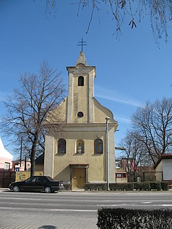 Church of Holy Trinity | |
 Rovinka Location of Rovinka in the Bratislava Region | |
| Coordinates: 48°06′N 17°14′E / 48.100°N 17.233°ECoordinates: 48°06′N 17°14′E / 48.100°N 17.233°E | |
| Country | Slovakia |
| Region | Bratislava |
| District | Senec |
| First mentioned | 1274 |
| Area | |
| • Total | 8.853 km2 (3.418 sq mi) |
| Elevation | 132 m (433 ft) |
| Population (2011) | |
| • Total | 2,250 |
| • Density | 250/km2 (660/sq mi) |
| Postal code | 900 41 |
| Area code(s) | 421-2 |
| Car plate | SC |
| Website | www.obecrovinka.sk |


Rovinka (German : Waltersdorf) (Hungarian: Csölle) is a village and municipality in western Slovakia in Senec District in the Bratislava Region.

A House in Rovinka
History[]
In historical records the village was first mentioned in 1274. Until their expulsion in 1945 the village was inhabited by Germans.
Geography[]
The municipality lies at an altitude of 132 metres and covers an area of 8.853 km².
Demographics[]
According to the 2011 census, the municipality had 2,250 inhabitants. 1,998 of inhabitants were Slovaks, 78 Hungarians, 23 Czechs, 12 Germans, 1 Kazakh and 139 others and unspecified.[1]
References[]
External links/Sources[]
![]() Media related to Rovinka at Wikimedia Commons
Media related to Rovinka at Wikimedia Commons
- Official page
- https://web.archive.org/web/20070513023228/http://www.statistics.sk/mosmis/eng/run.html
This Bratislava location article is a stub. You can help Wikipedia by . |
Categories:
- Villages and municipalities in Senec District
- Bratislava Region geography stubs