Milton, Massachusetts
Milton, Massachusetts | |
|---|---|
 Seal | |
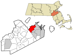 Location in Norfolk County in Massachusetts | |
 Milton Location in Norfolk County in Massachusetts | |
| Coordinates: 42°15′00″N 71°04′00″W / 42.25000°N 71.06667°WCoordinates: 42°15′00″N 71°04′00″W / 42.25000°N 71.06667°W | |
| Country | |
| State | |
| County | |
| Settled | 1640 |
| Incorporated | 1662 |
| Government | |
| • Type | Representative town meeting |
| • Town Administrator | Michael Dennehy |
| Area | |
| • Total | 34.4 km2 (13.3 sq mi) |
| • Land | 33.8 km2 (13.0 sq mi) |
| • Water | 0.6 km2 (0.2 sq mi) |
| Elevation | 40 m (130 ft) |
| Population (2010)[1] | |
| • Total | 27,003 |
| • Density | 780/km2 (2,000/sq mi) |
| Time zone | UTC−5 (Eastern) |
| • Summer (DST) | UTC−4 (Eastern) |
| ZIP Code | 02186 |
| Area code(s) | 617 and 857 |
| FIPS code | 25-41690 |
| GNIS feature ID | 0619459 |
| Website | www.townofmilton.org |

Milton is a town in Norfolk County, Massachusetts, United States, and an affluent suburb of Boston. The population was 27,003 at the 2010 census.[1] Milton is the birthplace of former U.S. President George H. W. Bush and architect Buckminster Fuller. In 2007, 2009, and 2011, Money magazine listed Milton as 7th, 5th, and 2nd, respectively, on its annual list of the "Best Places to Live" in the United States.[2]
Milton is located between the Neponset River and the Blue Hills. It is bordered by Boston's Dorchester and Mattapan neighborhoods to the north and its Hyde Park neighborhood to the west; Quincy to the east and south; Randolph to the south, and Canton to the west.
History[]
Before independence[]
Before the Europeans settled in what is now Milton, the area was inhabited by the Neponset tribe of the Massachusett people. During the spring and summer, they would inhabit the marshes of the Neponset River and Squantum, living off the plentiful supply of seafood. In the fall and winter, they would migrate inland to the Blue Hills to hunt game in the thickly forested hills. The Massachusett people named the area 'Unquatiquisset' or alternatively 'Unquity' meaning "Lower Falls", denoting the place where the Neponset River meets the Boston Harbor and Massachusetts Bay.
Milton was settled in the 1630s as a part of Dorchester by Puritans from England. Richard Callicott, one of the first settlers, built a trading post near the Neponset River and negotiated the purchase of Milton from Sachem Cutshamekin. Many of the settlers arrived during the 1650s, fleeing the aftermath of Oliver Cromwell's deposition from power and the English Civil War.[3] The original name for the area, translated to "Lower Falls" was adapted as "Lower Mills" after the establishment of the Israel Stoughton Grist Mill in 1634. In 1662, "that part of the Town of Dorchester which is situated on the south side of the Neponset River commonly called 'Unquatiquisset' was incorporated as an independent town and named Milton in honor of Milton Abbey, Dorset, England."
Many early Puritan families of Milton became influential in the Massachusetts Bay Colony, such as: the Sumners, Houghtons, Hutchinsons, Stoughtons, Tuckers, Voses, Glovers and Babcocks.[4]

A powder mill established in 1674 may have been the first in the earliest in the colonies, taking advantage of the town's water power sites. Boston investors, seeing the potential of the town and its proximity to the city, provided the capital to develop 18th-century Milton as an industrial area, including an iron slitting mill, paper and sawmills, and the first chocolate factory in New England (the Walter Baker Chocolate Factory) in 1764, which was converted from the old Stoughton Grist Mill. Laying of streetcar lines fueled the rapid expansion of residential development.
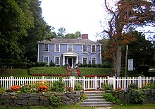
The Suffolk Resolves were signed in Milton in 1774, and were used as a model by the drafters of the Declaration of Independence in 1776. The Suffolk Resolves House, where the Resolves were passed, still stands and it is maintained as the headquarters of the Milton Historical Society. At the time of the Resolves it was owned by Capt. Daniel Vose, a well-known businessman, and later a representative to the Provincial Congress.[5] The house was moved to a new location at 1370 Canton Avenue in West Milton in order to save it from demolition at its previous location in "Milton Village" at Lower Mills. They were the "Suffolk Resolves" because Milton was part of Suffolk County until 1793, when Norfolk County split off, leaving only Boston and Chelsea in Suffolk County.
Two royal governors of Massachusetts, Jonathan Belcher and Thomas Hutchinson, had houses in Milton. The Governor Belcher House dates from 1777, replacing the earlier home destroyed in fire in 1776, and it is privately owned on Governor Belcher Lane in East Milton. Although Hutchinson's house was demolished in the 1940s, Governor Hutchinson's Field, owned by the Trustees of Reservations today is a wide expanse of greenery on Milton Hill, with a view of the Neponset River estuary and the skyscrapers of Boston six miles (10 km) away. Both Governor Belcher's house and Governor Hutchinson's field are on the National Register of Historic Places.
After independence[]
During the 17th and 18th centuries, Milton was a prosperous agricultural town. The town grew wealthy in the 19th century with the booming China Trade and the industrialization of Massachusetts during the early Industrial Revolution. As a result, many wealthy Bostonians built grand country-estates set on vast grounds throughout the former farmlands of Milton. Most of these estates were concentrated on Milton Hill, Brush Hill and Upper Canton Avenue. Among the last remaining of these intact estates is the W.E.C Eustis Estate on Canton Avenue.
During the 20th century, the character of the town changed from that of agriculture and rural retreat for the wealthy to suburban. The population of the town exploded following World War II. By the 1950s, many of the big estates were broken into subdivisions as the town's residential growth continued.
The town was home to America's first piano factory. Revolutionary Milton is the setting of the opening of the 1940 bestselling historical novel Oliver Wiswell by Kenneth Roberts. The Blue Hill Meteorological Observatory is located in the town, home of the nation's oldest continuously kept meteorological records.[6]
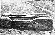
The Granite Railway passed from Quincy to the Neponset River in Milton, beginning in 1826. It is often called the first commercial railroad in the United States, as it was the first chartered railway to evolve into a common carrier without an intervening closure. A centennial historic plaque from 1926 and an original switch frog and section of track from the railway can be found in the gardens on top of the Southeast Expressway (Interstate 93) as it passes under East Milton Square. The frog had been displayed at the Chicago World's Fair in 1893.[7]
East Milton Square developed as a direct result of the Granite Railway. Four sheds there were used to dress the granite stone prior to it being brought by rail to the wharf for transfer to boats. East Milton Square was originally termed the "Railway Village" and a train station was located there after 1871 when the Granite Railway became a passenger line of the Old Colony Railroad. The Blue Bell Tavern, which was also a hotel, served as the headquarters of the Granite Railway and it was later named the Russell House. It was located on the site of the current United States Post Office in East Milton Square.

In 1801 Josiah Bent began a baking operation in Milton, selling "water crackers" or biscuits made of flour and water that would not deteriorate during long sea voyages from the port of Boston. The crackling sound occurred during baking, hence the name. This is where the American term "cracker" originated. His company later sold the original hardtack crackers used by troops during the American Civil War. The company, Bent's Cookie Factory, is still located in Milton and continues to sell these items to Civil War reenactors and others.
Robert Bennet Forbes was a noted China Trade merchant, sea captain, and philanthropist during the Irish Famine. He built a Greek Revival mansion in 1833 at 215 Adams Street on Milton Hill. The Captain Robert Bennet Forbes House is now listed on the National Register of Historic Places and is open for tours. In addition to artifacts from the China Trade period, the museum's grounds include a log cabin replica and a collection of Lincoln memorabilia.
George Herbert Walker Bush was born at 173 Adams Street on Milton Hill on June 12, 1924. He became the 41st President of the United States, serving from 1989 to 1993, and his son would become the 43rd President. Coincidentally, Adams Street is named for the family of Presidents John Adams and John Quincy Adams, who lived on the same street just a few miles southeast in Quincy, Massachusetts. The Bush Family moved from Milton to Greenwich, Connecticut, in 1925. The Victorian house where President Bush was born is now privately owned and not open to the public.
Geography[]
According to the United States Census Bureau, the town has a total area of 13.3 sq mi (34.4 km2), of which, 13.1 sq mi (33.8 km2) is land and the balance is water.
Great Blue Hill in the Blue Hills Reservation is the highest point in Norfolk County. The summit houses the Blue Hill Observatory, home of the longest continuous weather record in North America, along with multiple radio transmitters.
There are no official wards or neighborhoods defined in the town's governance and community planning processes.[8]
There are three GNIS populated places located in the town:[9]
- Milton (42°14'58"N 71°03'58"W),
- Milton Center (42°15'15"N 71°04'48"W), and
- East Milton (42°15'30"N 71°02'33"W).
Although geopolitical lines do not form neighborhoods in Milton, there are many distinct neighborhoods, such as the Columbine Rocks, Indian Cliffs, Scott's Woods, Brush Hill, Milton Village and Edge Hill Park, among others.
Climate[]
Milton is often cited as being the windiest city in the United States, with an annual average wind speed of 15.4 mph (24.8 km/h) measured at the Blue Hill Meteorological Observatory.[10][11][12]
| hideClimate data for Blue Hills Reservation (Blue Hill Meteorological Observatory), 1891−2020 normals, extremes 1885−present | |||||||||||||
|---|---|---|---|---|---|---|---|---|---|---|---|---|---|
| Month | Jan | Feb | Mar | Apr | May | Jun | Jul | Aug | Sep | Oct | Nov | Dec | Year |
| Record high °F (°C) | 68 (20) |
71 (22) |
89 (32) |
94 (34) |
96 (36) |
99 (37) |
100 (38) |
101 (38) |
99 (37) |
88 (31) |
81 (27) |
74 (23) |
101 (38) |
| Average high °F (°C) | 33.8 (1.0) |
35.1 (1.7) |
43.5 (6.4) |
55.0 (12.8) |
66.4 (19.1) |
74.7 (23.7) |
80.2 (26.8) |
78.2 (25.7) |
71.1 (21.7) |
60.6 (15.9) |
48.9 (9.4) |
37.7 (3.2) |
57.1 (13.9) |
| Daily mean °F (°C) | 25.9 (−3.4) |
26.6 (−3.0) |
34.5 (1.4) |
44.9 (7.2) |
55.5 (13.1) |
64.3 (17.9) |
70.0 (21.1) |
68.3 (20.2) |
61.5 (16.4) |
51.3 (10.7) |
40.7 (4.8) |
30.1 (−1.1) |
47.8 (8.8) |
| Average low °F (°C) | 18.5 (−7.5) |
19.1 (−7.2) |
27.0 (−2.8) |
36.6 (2.6) |
46.5 (8.1) |
55.6 (13.1) |
61.7 (16.5) |
60.5 (15.8) |
53.7 (12.1) |
43.6 (6.4) |
33.8 (1.0) |
23.2 (−4.9) |
40.0 (4.4) |
| Record low °F (°C) | −16 (−27) |
−21 (−29) |
−5 (−21) |
6 (−14) |
27 (−3) |
36 (2) |
44 (7) |
39 (4) |
28 (−2) |
21 (−6) |
5 (−15) |
−19 (−28) |
−21 (−29) |
| Average precipitation inches (mm) | 4.24 (108) |
3.99 (101) |
4.59 (117) |
4.14 (105) |
3.67 (93) |
3.80 (97) |
3.62 (92) |
4.02 (102) |
3.92 (100) |
4.14 (105) |
4.34 (110) |
4.46 (113) |
48.92 (1,243) |
| Average snowfall inches (cm) | 16.3 (41) |
16.8 (43) |
12.0 (30) |
4.1 (10) |
0.1 (0.25) |
0.0 (0.0) |
0.0 (0.0) |
0.0 (0.0) |
0.0 (0.0) |
0.4 (1.0) |
3.3 (8.4) |
11.5 (29) |
62.3 (158) |
| Mean monthly sunshine hours | 132.1 | 146.7 | 174.0 | 185.6 | 220.2 | 231.8 | 258.1 | 242.5 | 204.1 | 182.1 | 133.3 | 125.9 | 2,236.4 |
| Percent possible sunshine | 46.3 | 50.9 | 48.5 | 47.9 | 50.4 | 52.7 | 58.0 | 58.7 | 56.7 | 55.1 | 47.0 | 45.9 | 51.5 |
| Source: Blue Hill Observatory & Science Center[13][14] | |||||||||||||
Demographics[]
| Year | Pop. | ±% |
|---|---|---|
| 1850 | 2,241 | — |
| 1860 | 2,669 | +19.1% |
| 1870 | 2,683 | +0.5% |
| 1880 | 3,206 | +19.5% |
| 1890 | 4,278 | +33.4% |
| 1900 | 6,578 | +53.8% |
| 1910 | 7,924 | +20.5% |
| 1920 | 9,382 | +18.4% |
| 1930 | 16,434 | +75.2% |
| 1940 | 18,708 | +13.8% |
| 1950 | 22,395 | +19.7% |
| 1960 | 26,375 | +17.8% |
| 1970 | 27,190 | +3.1% |
| 1980 | 25,860 | −4.9% |
| 1990 | 25,725 | −0.5% |
| 2000 | 26,062 | +1.3% |
| 2010 | 27,003 | +3.6% |
| 2020 | 28,630 | +6.0% |
| * = population estimate. Source: United States census records and Population Estimates Program data.[15][16][17][18][19][20][21][22][23][24] | ||
As of the census[25] of 2010, there were 27,002 people, 9,274 households, and 6,835 families residing in the town. The racial makeup of the town was 77.4% White, 14.3% Black or African American, 0.1% Native American, 4.1% Asian, 0.0% Pacific Islander, 0.6% from other races, and 2.5% from two or more races. Hispanic or Latino of any race were 3.3% of the population.
As of the census[25] of 2000, the population density was 1,999.1 people per square mile (771.7/km2). There were 9,161 housing units at an average density of 702.7 per square mile (271.2/km2).
The top six ancestries of Milton are Irish (38.0%), Italian (11.3%), English (8.6%), West Indian (4.8%), and German (4.7%).
Milton also has been cited as having the highest percentage of residents citing Irish lineage of any town in the United States per capita—38%.[26]
There were 8,982 households, out of which 37.5% had children under the age of 18 living with them, 60.1% were married couples living together, 11.9% had a female householder with no husband present, and 24.8% were non-families. Of all households 21.2% were made up of individuals, and 12.7% had someone living alone who was 65 years of age or older. The average household size was 2.79 and the average family size was 3.27.
In the town, the population was spread out, with 25.8% under the age of 18, 8.0% from 18 to 24, 25.9% from 25 to 44, 24.1% from 45 to 64, and 16.2% who were 65 years of age or older. The median age was 39 years. For every 100 females, there were 89.7 males. For every 100 females age 18 and over, there were 84.2 males.
According to a 2010 estimate,[27] the median income for a household in the town was $103,373, and the median income for a family was $131,025. Males had a median income of $85,748 versus $61,500 for females. The per capita income for the town was $47,589. About 1.6% of families and 2.8% of the population were below the poverty line, including 2.2% of those under age 18 and 4.5% of those age 65 or over.
Education[]
There are six public schools in Milton, including four elementary schools: Collicot, Cunningham, Glover, and Tucker; one middle school, Charles S. Pierce; and the Milton High School. There are also private schools, high schools and elementary/middle schools, including the prep school Milton Academy, the girls' school Fontbonne Academy, , St. Agatha's, Thacher Montessori School, Carriage House Schools, and Delphi Academy.
Milton is also home to Curry College, a small liberal arts institution.
Milton is also one of the few school systems to offer a French immersion program, starting in Grade 1. For those students that participate in this program, all classes are taught in French during grades 1 and 2, allowing children to become fluent in this language. In grades 3 - 5, some classes are taught in English as well to prepare for the MCAS. This program continues through grade 12. Spanish/English is taught as well. In the middle school Latin is available for the Spanish/English students.
Transportation[]
Milton lies within the Massachusetts Bay Transportation Authority district. Fixed-route service includes the Ashmont-Mattapan High Speed Line, a light rail extension of the Red Line. Milton has 4 stops: Milton, Central Avenue, Valley Road, and Capen Street. This was originally a steam railway prior to becoming a trolley line. Massachusetts Route 28 and Massachusetts Route 138 run north and south across Milton, and Interstate 93, which is also U.S. Route 1 and Massachusetts Route 3, loops around the town near the southern and eastern borders.[28]
Cycling is a popular form of transportation and recreation in Milton. The opening of the reconnected Milton with Boston Harbor via Port Norfolk, Dorchester. Other cycling routes and locations include Turner's Pond, Brook Road, Blue Hills Parkway, Milton Cemetery, and the Pine Tree Brook greenway.[29]
The Milton Yacht Club began in 1902, with a small building in the Lower Mills area beside the Neponset River that was formerly the police department for the town of Milton. Various boats continue to be anchored there or stored on the dock during the winter.
Notable people[]
- Dana Barros, NBA player, Boston Celtics, Seattle SuperSonics
- Jonathan Belcher, governor of Massachusetts Bay, New Hampshire, and New Jersey Provinces
- Josiah Bent, manufacturer, founder of G.H. Bent Company Factory
- Tim Bulman, Boston College and NFL player, was born in Milton
- George H. W. Bush, 41st President of the United States, was born in Milton
- Brian Camelio, musician and crowdfunding pioneer, founder of ArtistShare
- Ken Casey, bassist and co-lead vocalist of Celtic punk rock group Dropkick Murphys
- Chris Cleary, professional soccer player
- Hal Clement, science-fiction writer
- Jill Ker Conway, Australian-born novelist
- Stephen Davis, music journalist and biographer[30]
- T. S. Eliot, poet, was a student at Milton Academy
- William Ralph Emerson, known for shingle style architecture
- Jim Fahey, NHL player, New Jersey Devils
- Thomas Flatley, real-estate developer
- Elbie Fletcher, All-Star first baseman for Pittsburgh Pirates
- John Ferruggio, led evacuation of Pan Am Flight 93 in 1970[31]
- John Murray Forbes, railroad magnate, merchant, philanthropist and abolitionist
- Robert Bennet Forbes, sea captain, China merchant, ship owner, and writer
- Buckminster Fuller, architect and futurist; born in Milton
- George V. Higgins, attorney, crime novelist, The Friends of Eddie Coyle
- Rich Hill, pitcher for Los Angeles Dodgers, was born in Milton
- Thomas Hutchinson, 18th Century governor of Massachusetts Bay province
- Abigail Johnson, president of Fidelity Investments
- Charles C. Johnson, far-right political activist
- Howard Deering Johnson, restaurateur, founder of Howard Johnson's franchising
- Trish Karter, entrepreneur
- Jordan Knight, singer for band New Kids on the Block
- Janet Langhart, model and journalist
- Johnny Martorano, Winter Hill Gang member
- Jidenna Theodore Mobisson, attended Milton Academy
- Charles Munch, music director of Boston Symphony Orchestra[32]
- Kate O'Neill, distance runner
- William Ordway Partridge, sculptor, poet, and author
- Deval Patrick, former Governor of Massachusetts, attended Milton Academy
- Everett P. Pope, Medal of Honor recipient; born in Milton
- Mike Ryan, NHL player, Buffalo Sabres
- William Saltonstall, eighth principal of Phillips Exeter Academy
- Jenny Slate, comedian on Saturday Night Live
- Jen Statsky, TV writer and comedian
- Margaret Sutermeister (1875–1950), photographer
- Luis Tiant, former Boston Red Sox pitcher
- Steve Trapilo, former NFL player for New Orleans Saints
- Ronan Tynan, Irish tenor[33]
- Mark Vonnegut, writer, son of author Kurt Vonnegut
- Roger Vose, U.S. Representative from New Hampshire
- Barry Wood, Harvard quarterback in College Football Hall of Fame; born in Milton
- Keith Yandle, NHL player, Florida Panthers; born in Milton
Points of interest[]
Milton has 30 sites or districts listed on the National Register of Historic Places, including the following:
- Blue Hill Meteorological Observatory
- Captain Robert Bennet Forbes House
- Governor Hutchinson's Field
- Granite Railway
- Suffolk Resolves House
Other places of interest include:
- Blue Hills Reservation
- Eustis Estate
- Houghton's Pond
- Milton Academy
- Curry College
- Carriage House School
In popular culture[]
Filming locations featuring Milton[]
- The Thomas Crown Affair (1968)[citation needed]
- Love Story (1970)
- The Friends of Eddie Coyle (1973)
- This Old House TV Series
- The Witches of Eastwick (1987)
- What's the Worst That Could Happen? (2001)
- Spartan (2005)
- The Box (2009)
- The Social Network (2010)
- The Judge (2013)
Books featuring Milton[]
- Kenneth Roberts — Oliver Wiswell (1940)
- Johnny Tremain
The Late George Apley, by John Marquand
Notes[]
- ^ Jump up to: a b "Population and Housing Occupancy Status: 2010 - State -- County Subdivision, 2010 Census Redistricting Data (Public Law 94-171) Summary File". U.S. Census Bureau. Retrieved 2011-06-26.[dead link]
- ^ "Best Places to Live 2009", Money magazine
- ^ "Archived copy". Archived from the original on 2006-08-13. Retrieved 2006-08-14.CS1 maint: archived copy as title (link)
- ^ "Archived copy". Archived from the original on 2006-08-13. Retrieved 2006-08-14.CS1 maint: archived copy as title (link) Town of Milton
- ^ The Story of the Suffolk Resolves, c.1973, Milton, Massachusetts Historical Commission; 60 pgs: http://www.miltonhistoricalsociety.org/DigitalArchives/1973%20The%20Story%20of%20the%20Suffolk%20Resolves.pdf
- ^ Blue Hill Meteorological Observatory
- ^ "The First Railroad in America".
- ^ Town of Milton website Archived 2006-08-13 at the Wayback Machine
- ^ GNIS public query
- ^ Van Riper, Tom. Forbes https://www.forbes.com/2007/07/20/weather-storms-us-biz-cx_tvr_0720weather.html. Missing or empty
|title=(help) - ^ http://voices.yahoo.com/windiest-weather-cities-united-states-6761182.html[permanent dead link]
- ^ "Archived copy". Archived from the original on 2009-03-10. Retrieved 2009-04-18.CS1 maint: archived copy as title (link)
- ^ "Blue Hill Meteorological Observatory 1891-2020 Means and Extremes". Blue Hill Meteorological Observatory. 7 May 2013. Retrieved May 30, 2021.
- ^ "Blue Hill Observatory daily sunshine data". Blue Hill Meteorological Observatory. Retrieved October 11, 2015.
- ^ "Total Population (P1), 2010 Census Summary File 1". American FactFinder, All County Subdivisions within Massachusetts. United States Census Bureau. 2010.
- ^ "Massachusetts by Place and County Subdivision - GCT-T1. Population Estimates". United States Census Bureau. Retrieved July 12, 2011.
- ^ "1990 Census of Population, General Population Characteristics: Massachusetts" (PDF). US Census Bureau. December 1990. Table 76: General Characteristics of Persons, Households, and Families: 1990. 1990 CP-1-23. Retrieved July 12, 2011.
- ^ "1980 Census of the Population, Number of Inhabitants: Massachusetts" (PDF). US Census Bureau. December 1981. Table 4. Populations of County Subdivisions: 1960 to 1980. PC80-1-A23. Retrieved July 12, 2011.
- ^ "1950 Census of Population" (PDF). Bureau of the Census. 1952. Section 6, Pages 21-10 and 21-11, Massachusetts Table 6. Population of Counties by Minor Civil Divisions: 1930 to 1950. Retrieved July 12, 2011.
- ^ "1920 Census of Population" (PDF). Bureau of the Census. Number of Inhabitants, by Counties and Minor Civil Divisions. Pages 21-5 through 21-7. Massachusetts Table 2. Population of Counties by Minor Civil Divisions: 1920, 1910, and 1920. Retrieved July 12, 2011.
- ^ "1890 Census of the Population" (PDF). Department of the Interior, Census Office. Pages 179 through 182. Massachusetts Table 5. Population of States and Territories by Minor Civil Divisions: 1880 and 1890. Retrieved July 12, 2011.
- ^ "1870 Census of the Population" (PDF). Department of the Interior, Census Office. 1872. Pages 217 through 220. Table IX. Population of Minor Civil Divisions, &c. Massachusetts. Retrieved July 12, 2011.
- ^ "1860 Census" (PDF). Department of the Interior, Census Office. 1864. Pages 220 through 226. State of Massachusetts Table No. 3. Populations of Cities, Towns, &c. Retrieved July 12, 2011.
- ^ "1850 Census" (PDF). Department of the Interior, Census Office. 1854. Pages 338 through 393. Populations of Cities, Towns, &c. Retrieved July 12, 2011.
- ^ Jump up to: a b "U.S. Census website". United States Census Bureau. Retrieved 2008-01-31.
- ^ ePodunk Irish Index
- ^ United States Census
- ^ "Archived copy" (PDF). Archived from the original (PDF) on 2006-03-04. Retrieved 2006-03-01.CS1 maint: archived copy as title (link)
- ^ "Archived copy". Archived from the original on 2004-02-03. Retrieved 2004-02-03.CS1 maint: archived copy as title (link)
- ^ Caleb Daniloff, "Rock from Axl to Zep" Archived 2008-10-24 at the Wayback Machine, BU Today, October 21, 2008.
- ^ Marquard, Bryan (2010-06-22). "John Ferruggio, at 84; hero of 1970 Pan Am hijacking". Boston Globe. Retrieved 2010-06-27.
- ^ Holoman, D. Kern (2012). Charles Munch. Oxford University Press. ISBN 9780199912575.
- ^ "Famous folks from Milton". Boston Globe. Retrieved 2012-01-02.
1. "TOTAL POPULATION Survey/Program: Decennial Census, Years: 2010, U.S. Census Bureau." Retrieved 2020-06-03 https://data.census.gov/cedsci/table?q=population%20milton,%20ma&g=1600000US2541725&hidePreview=false&tid=DECENNIALSF12010.P1&vintage=2018&layer=VT_2018_160_00_PY_D1&cid=DP05_0001E
References[]
- Massachusetts Observed Climate Normals (1981–2010)
- The History of Milton, Mass., 1640–1887 by Albert Kendall Teele, published 1886, 688 pages.
- Milton Records: Births, Marriages and Deaths, 1662–1843. Published 1900.
- Dutton, E.P. Chart of Boston Harbor and Massachusetts Bay with Map of Adjacent Country. Published 1867. A good map of roads and rail lines around Milton including the Granite Railroad.
- Old USGS Maps of Milton area.
- https://web.archive.org/web/20081013100415/http://www.muninetguide.com/schools/MA/Milton/Tucker/
- https://web.archive.org/web/20080907194054/http://www.muninetguide.com/schools/MA/Milton/Collicot/
- https://www.townofmilton.org/people/michael-d-dennehy
External links[]
| Wikivoyage has a travel guide for Milton (Massachusetts). |
| Wikimedia Commons has media related to Milton, Massachusetts. |
| show Municipalities and communities of Norfolk County, Massachusetts, United States |
|---|

| show Authority control |
|---|
- Milton, Massachusetts
- Irish-American culture in Massachusetts
- Irish-American history
- Streetcar suburbs
- Towns in Massachusetts
- Towns in Norfolk County, Massachusetts