Miscanti Lake
| Miscanti Lake | |
|---|---|
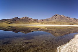 Laguna Miscanti. | |
 Miscanti Lake | |
| Location | Antofagasta Region |
| Coordinates | 23°44′S 67°47′W / 23.733°S 67.783°WCoordinates: 23°44′S 67°47′W / 23.733°S 67.783°W[1] |
| Catchment area | 303 km2 (117 sq mi)[2] |
| Basin countries | Chile |
| Surface area | 13.4 km2 (5.2 sq mi)[2] |
| Surface elevation | 4,140 m (13,580 ft)[3] |
| References | [1][2] |

Miscanti Lake (Spanish: Laguna Miscanti) is a brackish water lake located in the altiplano of the Antofagasta Region, in northern Chile. Miñiques volcano and Cerro Miscanti tower over this lake. This heart-shaped lake has a deep blue color. The western shoreline of the lake is separated by less than 1 km from the drainage divide between the lake and the Salar de Atacama basins.[2] Laguna Miscanti basin also has a common boundary with Salar de Talar basin.[4]
A lava flow from an eruption of Miñiques separated Miscanti Lake from Miñiques Lake.[5]
The lake is part of one of the seven sectors of Los Flamencos National Reserve.

Geography[]
Laguna Miscanti lies in the Central Andes[6] of Chile,[7] southeast of the Salar de Atacama. The closest town is Socaire, 20 kilometres (12 mi) away from the lake.[8] In 2015, one in three tourists who went to the Los Flamencos National Reserve visited Miscanti and Laguna Miñiques.[9]
Hydrography and geology[]
It is a maximally 10 metres (33 ft) deep lake with[10] clear[11] brackish water which covers a surface area of 13.5 square kilometres (5.2 sq mi);[10] the lake has the shape of an arrowhead with a peninsula jutting from the northern shore.[7] The lake has a flat lakefloor that is subdivided into two basins by a lava flow.[12] In the Atacama Altiplano, Laguna Miscanti is among the biggest waterbodies.[13] The mountains Cerro Miscanti (5,622 metres (18,445 ft)) and Cerro Miniques (5,910 metres (19,390 ft)) lie northeast and south of the lake, respectively.[14]
1.5 kilometres (0.93 mi) south of[15] the lake lies another waterbody, Laguna Miniques.[16] In the past, the two lakes were connected, producing a large waterbody which has left beach terraces in the landscape[10] and whose water levels were about 20 metres (66 ft) higher than today.[17] The separation of the lakes probably occurred during the Pleistocene, when a lava flow erupted from Cerro Miniques split the lake basin in two.[18][19] A number of creeks enter into Laguna Miscanti from the north, east and south (Quebrada de Chaquisoqui[3]), and two springs can be found on its northern shores.[7]
Miscanti and Miniques occupy fault-bound basins,[15][10][20] which are controlled by the Quebrada Nacimiento fault;[17] the fault is also known as the Miscanti Fault and is part of a detachment fault system east of the Salar de Atacama,[21] which separates the Western Cordillera from the Cordillera Domeyko.[20][11] This fault extends from the Purico complex,[22] Llano de Chajnantor to Cerro Miniques and has formed a ridge, which has dammed lava flows from Cerro Miscanti and Cerro Miniques.[19] The basins developed during the Pliocene and Pleistocene;[17] Laguna Lejia also developed along this fault[20] and the fault segment there is also known as Miscanti-Callejon de Varela fault.[23] Volcanoes[20] including Lascar are constructed on this fault,[24] and the Cerros Saltar and Corona north and south of Lascar are lined up on it as well.[25]
Hydrology[]
The catchment of the lake consists mainly of volcanic and sedimentary rocks ranging from Miocene to Holocene age and covers a surface area of 320 square kilometres (120 sq mi),[10] with Quaternary volcanoes that reach elevations of 5,000–6,000 metres (16,000–20,000 ft).[8] The Cordon de Puntas Negras is the principal source of water.[17] Water reaches Laguna Miscanti principally as groundwater,[11] which is directed there by the fault; this may explain why Laguna Miscanti is a permanent lake rather than a playa.[18]
The lake has no surface outflow. Presently, water seeps to Miniques through a lava flow[10] along the path of the Quebrada Nacimiento fault;[17] during former lake highstands a combined lake overflowed into the Pampa Varela basin[10] south-southwest of Miniques.[14] The main removal mechanism of water from Laguna Miscanti however is evaporation.[20] Some water is diverted from the catchment and forms a water supply to the town of Peine.[26]
Climate[]
Presently, the regional climate is arid[16] (average precipitation 200–250 millimetres per year (7.9–9.8 in/year)) and cold (average annual temperature 2 °C (36 °F)), leading to the development of ice on the lake surface during winter.[10] The lake area is usually a little warmer than the surrounding region.[27] The region lies between areas dominated by summer precipitation in the northeast and areas dominated by winter precipitation in the southwest.[16]
In the late Pleistocene and early Holocene the climate was much wetter and lakes expanded, while the middle Holocene was dry[16] as was the last glacial maximum[28] and the Central Andean Pluvial Event (especially its first stage[29]).[30] The late Pleistocene-early Holocene wet period was particularly noticeable in the Altiplano, where two separate phases of the Lake Tauca occurred.[31] During the middle Holocene dry period, the lake may have dried up completely forming a bog,[11] while after about 4,000 years ago moisture availability increased again.[32] Climate variability influenced human settlement in the region during the Holocene, which took place mainly during wetter periods[33] and became concentrated in several environmentally favourable spaces during dry periods.[15] An archeological site called "Miscanti-1" is found on the southeastern lake shore.[34]
Biology[]
Widgeonweed grows at the lakeshores.[35] Charophytes,[36] Chara and Myriophyllum are two further aquatic plants that have been identified in the lake. During its highstands, algal bioherms[35] and stromatolithes developed in the water.[17] Diatoms and ostracodes have been identified in the lake sediments,[37] and amphipods have been found in the lake waters.[38]
Meadows consisting of Fabiana, Festuca and grow around the lake, with sparser vegetation found on the upland,[11] consisting of Baccharis species also known as "tolar" and ichu.[39] Fauna that inhabits the area includes birds like flamingos, horned coot, rhea and speckled teal, and mammals like the vicuña.[11] Laguna Miscanti and Laguna Miniques are part of the third sector of the Los Flamencos National Reserve.[40]
References[]
- ^ Jump up to: a b Earth Info, earth-info.nga.mil webpage Archived 2012-05-04 at the Wayback Machine
- ^ Jump up to: a b c d (in Spanish) Geoquímica de aguas en cuencas cerradas: I, II y III Regiones - Chile Archived 2011-07-21 at the Wayback Machine Laguna Miscanti
- ^ Jump up to: a b Niemeyer 1980, p. 202.
- ^ Niemeyer 1980, p. 206.
- ^ "Miñiques". Global Volcanism Program. Smithsonian Institution.
- ^ Grosjean 2001, p. 35.
- ^ Jump up to: a b c Valero-Garcés et al. 1996, p. 3.
- ^ Jump up to: a b Niemeyer 1980, p. 201.
- ^ Molina, Raúl (31 December 2019). "Nostalgias, conversiones y desbordes en San Pedro de Atacama". Antropologías del Sur (in Spanish). 6 (12): 273. doi:10.25074/rantros.v6i12.1548. ISSN 0719-5532.
- ^ Jump up to: a b c d e f g h Grosjean 2001, p. 37.
- ^ Jump up to: a b c d e f Núñez et al. 2018, p. 112.
- ^ Valero-Garcés et al. 1996, p. 6.
- ^ Valero-Garcés et al. 1996, p. 2.
- ^ Jump up to: a b Grosjean 2001, p. 38.
- ^ Jump up to: a b c Núñez et al. 2018, p. 111.
- ^ Jump up to: a b c d Grosjean 2001, p. 36.
- ^ Jump up to: a b c d e f Valero-Garcés et al. 1996, p. 4.
- ^ Jump up to: a b Valero-Garcés et al. 1999, p. 123.
- ^ Jump up to: a b González et al. 2009, p. 9.
- ^ Jump up to: a b c d e Valero-Garcés et al. 1999, p. 105.
- ^ Aron, Felipe; González, Gabriel; Veloso, Eugenio; Cembrano, José (2008). "Architecture and style of compressive Neogene deformation in the eastern-southeastern border of the Salar de Atacama Basin (22°30'-24°15'S): A structural setting for the active volcanic arc of the Central Andes". 7th International Symposium on Andean Geodynamics: 52. Retrieved 25 February 2018.
- ^ Davidson, Jon P.; de Silva, Shanaka L.; Holden, Peter; Halliday, Alex N. (10 October 1990). "Small-scale disequilibrium in a magmatic inclusion and its more silicic host". Journal of Geophysical Research: Solid Earth. 95 (B11): 17662. Bibcode:1990JGR....9517661D. doi:10.1029/JB095iB11p17661. ISSN 2156-2202.
- ^ Gardeweg, Sparks & Matthews 1998, p. 100.
- ^ Zellmer, Georg F.; Freymuth, Heye; Cembrano, José M.; Clavero, Jorge E.; Veloso, Eugenio A. E.; Sielfeld, Gerd G. (1 January 2014). "Altered mineral uptake into fresh arc magmas: insights from U–Th isotopes of samples from Andean volcanoes under differential crustal stress regimes". Geological Society, London, Special Publications. 385 (1): 189. Bibcode:2014GSLSP.385..185Z. doi:10.1144/SP385.9. ISSN 0305-8719. S2CID 128528082.
- ^ Gardeweg, Sparks & Matthews 1998, p. 92.
- ^ Calderón, Matías; Benavides, Catalina; Carmona, Javier; Gálvez, Damián; Malebrán, Natalia; Rodríguez, Manuela; Sinclaire, Denise; Urzúa, José (2016). "Gran Minería y Localidades Agrícolas en el Norte de Chile: Comparación Exploratoria de Tres Casos". Chungará (Arica). 48 (2): 295–305. doi:10.4067/S0717-73562016005000001. ISSN 0717-7356.
- ^ Romero, Hugo; Kampf, Stephanie (2003). Impacts of Climate Fluctuations and Climate Changes on the Sustainable Development of the Arid Norte Grande in Chile. Climate and Water. Advances in Global Change Research. 16. Springer, Dordrecht. p. 94. doi:10.1007/978-94-015-1250-3_5. ISBN 978-90-481-6386-1.
- ^ Grosjean 2001, p. 49.
- ^ Pfeiffer, Marco; Latorre, Claudio; Santoro, Calogero M.; Gayo, Eugenia M.; Rojas, Rodrigo; Carrevedo, María Laura; McRostie, Virginia B.; Finstad, Kari M.; Heimsath, Arjun; Jungers, Matthew C.; De Pol-Holz, Ricardo; Amundson, Ronald (1 October 2018). "Chronology, stratigraphy and hydrological modelling of extensive wetlands and paleolakes in the hyperarid core of the Atacama Desert during the late quaternary". Quaternary Science Reviews. 197: 237. Bibcode:2018QSRv..197..224P. doi:10.1016/j.quascirev.2018.08.001. ISSN 0277-3791.
- ^ Urrutia, Javier; Herrera, Christian; Custodio, Emilio; Jódar, Jorge; Medina, Agustín (20 December 2019). "Groundwater recharge and hydrodynamics of complex volcanic aquifers with a shallow saline lake: Laguna Tuyajto, Andean Cordillera of northern Chile". Science of the Total Environment. 697: 3. Bibcode:2019ScTEn.697m4116U. doi:10.1016/j.scitotenv.2019.134116. ISSN 0048-9697. PMID 32380610.
- ^ Núñez et al. 2018, p. 109.
- ^ Jara, Ignacio A.; Maldonado, Antonio; Eugenia de Porras, María (15 October 2020). "Late Holocene dynamics of the south American summer monsoon: New insights from the Andes of northern Chile (21°S)". Quaternary Science Reviews. 246: 10. Bibcode:2020QSRv..24606533J. doi:10.1016/j.quascirev.2020.106533. ISSN 0277-3791.
- ^ Valero-Garcés et al. 1996, p. 19.
- ^ Núñez et al. 2018, p. 110.
- ^ Jump up to: a b Grosjean 2001, p. 39.
- ^ Valero-Garcés et al. 1999, p. 117.
- ^ Valero-Garcés et al. 1996, p. 10.
- ^ Ríos-Escalante, Patricio De los; Morrone, Juan J.; Rivera, Reinaldo (1 January 2013). "A checklist of Hyalella (Amphipoda) from Chile". Crustaceana. 86 (12): 1429. doi:10.1163/15685403-00003256. ISSN 1568-5403.
- ^ Niemeyer 1980, p. 203.
- ^ Aravena, Fernando; Amado, Nelson (May 2014). "Abundancia y reproducción de la tagua cornuda (Fulica cornuta) en la Reserva Nacional Los Flamencos, Región de Antofagasta" (PDF). Sistema de Información de Biodiversidad (in Spanish). Corporación Nacional Forestal. p. 29. Retrieved 25 February 2018.
Sources[]
- Gardeweg, M. C.; Sparks, R. S. J.; Matthews, S. J. (1 February 1998). "Evolution of Lascar Volcano, Northern Chile". Journal of the Geological Society. 155 (1): 89–104. Bibcode:1998JGSoc.155...89G. doi:10.1144/gsjgs.155.1.0089. ISSN 0016-7649. S2CID 128916568.
- González, Gabriel; Cembrano, José; Aron, Felipe; Veloso, Eugenio E.; Shyu, J. Bruce H. (1 December 2009). "Coeval compressional deformation and volcanism in the central Andes, case studies from northern Chile (23°S–24°S)". Tectonics. 28 (6): TC6003. Bibcode:2009Tecto..28.6003G. doi:10.1029/2009TC002538. ISSN 1944-9194.
- Grosjean, M (February 2001). "A 22,000 14C year BP sediment and pollen record of climate change from Laguna Miscanti (23°S), northern Chile". Global and Planetary Change. 28 (1–4): 35–51. Bibcode:2001GPC....28...35G. doi:10.1016/S0921-8181(00)00063-1. ISSN 0921-8181.
- Niemeyer, Hans F. (1980). "HOYAS HIDROGRÁFICAS DE CHILE: SEGUNDA REGIÓN" (PDF) (in Spanish). Dirección General de Aguas. Archived from the original (PDF) on 4 March 2016. Retrieved 26 February 2018.
- Núñez, Lautaro; Loyola, Rodrigo; Cartajena, Isabel; López, Patricio; Santander, Boris; Maldonado, Antonio; de Souza, Patricio; Carrasco, Carlos (February 2018). "Miscanti-1: Human occupation during the arid Mid-Holocene event in the high-altitude lakes of the Atacama Desert, South America". Quaternary Science Reviews. 181: 109–122. Bibcode:2018QSRv..181..109N. doi:10.1016/j.quascirev.2017.12.010. ISSN 0277-3791.
- Valero-Garcés, Blas L.; Grosjean, Martin; Kelts, Kerry; Schreier, Hans; Messerli, Bruno (July 1999). "Holocene lacustrine deposition in the Atacama Altiplano: facies models, climate and tectonic forcing". Palaeogeography, Palaeoclimatology, Palaeoecology. 151 (1–3): 101–125. Bibcode:1999PPP...151..101V. doi:10.1016/S0031-0182(99)00018-8. ISSN 0031-0182.
- Valero-Garcés, Blas L.; Grosjean, Martin; Schwalb, Antje; Geyh, Mebus; Messerli, Bruno; Kelts, Kerry (1 July 1996). "Limnogeology of Laguna Miscanti: evidence for mid to late Holocene moisture changes in the Atacama Altiplano (Northern Chile)". Journal of Paleolimnology. 16 (1): 1–21. Bibcode:1996JPall..16....1V. doi:10.1007/BF00173268. ISSN 0921-2728. S2CID 128636498.
| hide | ||
|---|---|---|
| Rivers | ||
| Lakes | ||
| Salt pans | ||
| Wikimedia Commons has media related to Laguna Miscanti. |
- Lakes of Antofagasta Region
- Lakes of Chile