Mitchell, Australian Capital Territory
| Mitchell Canberra, Australian Capital Territory | |||||||||||||||
|---|---|---|---|---|---|---|---|---|---|---|---|---|---|---|---|
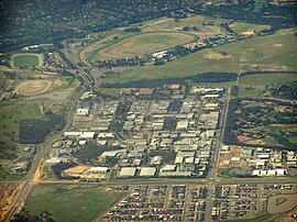 Mitchell viewed from the north | |||||||||||||||
 Mitchell | |||||||||||||||
| Coordinates | 35°13′09″S 149°08′06″E / 35.2192874°S 149.134957°ECoordinates: 35°13′09″S 149°08′06″E / 35.2192874°S 149.134957°E | ||||||||||||||
| Population | 0 (2016 census)[1] | ||||||||||||||
| • Density | 0.00/km2 (0.00/sq mi) | ||||||||||||||
| Postcode(s) | 2911 | ||||||||||||||
| Area | 7.4 km2 (2.9 sq mi) | ||||||||||||||
| District | Gungahlin | ||||||||||||||
| Territory electorate(s) | Yerrabi | ||||||||||||||
| Federal Division(s) | Fenner | ||||||||||||||
| |||||||||||||||

Mitchell (postcode: 2911) is a light-industrial estate of Canberra, Australia in the district of Gungahlin. Mitchell was named in honour of Major Sir Thomas Livingstone Mitchell, an explorer of inland New South Wales and Surveyor-General of New South Wales. The streets in Mitchell are named after Australian industrialists.[2]
In the 2016 census, Mitchell had no recorded population.[1]
It is commonly believed by Canberra residents that the suburb of Mitchell contains Exhibition Park in Canberra (EPIC) and also Thoroughbred Park (Canberra Racecourse). In fact, these facilities are located in the neighbouring suburb of Lyneham.
Mitchell is one of the two areas in Canberra where brothels may legally operate, along with Fyshwick. Mitchell also has other adult entertainment industry shops and one strip club.[citation needed].
History[]
A major fire at a chemical factory on Dacre Street early in the morning of 16 September 2011 saw a 10 kilometer exclusion zone put in place around the suburb. Residents in parts of Gungahlin, Belconnen and North Canberra were told to remain inside with windows their closed and schools inside the zone closed for the day. Around 100 people and 50 horses were evacuated from an event at nearby EPIC due to toxic smoke.[3]
Mitchell was selected as the site for the first Canberra light rail depot, with construction beginning in 2016. The facility opened in March 2019, including maintenance facilities and the network operations centre.[4] Despite this, a passenger stop in Mitchell was not constructed as part of stage one of the project. Following lobbying efforts by local businesses and the community, the ACT Government announced funding in 2018 for a stop to be constructed at a future stage.[5]
Geology[]
Rocks under Mitchell are from the Silurian age. Mitchell is built over calcareous shale of the Canberra Formation. From the south to Crace Hill is green-grey to reddish dacite.[6]
References[]
- ^ Jump up to: a b Australian Bureau of Statistics (27 June 2017). "Mitchell (State Suburb)". 2016 Census QuickStats. Retrieved 27 June 2017.

- ^ "Suburb Name search results". ACT Environment and Sustainable Development. Retrieved 10 February 2014.
- ^ Knaus, C; Kretowicz, E (16 September 2011). "Toxic smoke fears as industrial fire burns in Canberra". The Sydney Morning Herald. Retrieved 9 March 2019.
- ^ Probert, O (6 March 2019). "Canberra light rail depot opens". Rail Express. Retrieved 9 March 2019.
- ^ Burgess, K (4 June 2018). "Millions of dollars more for light rail stage two, plus a stop for Mitchell". The Canberra Times. Retrieved 9 March 2019.
- ^ Henderson, G. A. M.; Matveev, G. (1980). Geology of Canberra, Queanbeyan and Environs (Map). 1:50000.
This article on the geography of the Australian Capital Territory is a stub. You can help Wikipedia by . |
- Suburbs of Canberra
- Australian Capital Territory geography stubs