Monticello, Haute-Corse
show This article may be expanded with text translated from the corresponding article in French. (December 2008) Click [show] for important translation instructions. |
Monticello | |
|---|---|
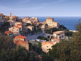 The village of Monticello | |
show Location of Monticello | |
 Monticello | |
| Coordinates: 42°37′05″N 8°57′16″E / 42.6181°N 8.9544°ECoordinates: 42°37′05″N 8°57′16″E / 42.6181°N 8.9544°E | |
| Country | France |
| Region | Corsica |
| Department | Haute-Corse |
| Arrondissement | Calvi |
| Canton | L'Île-Rousse |
| Government | |
| • Mayor (2020–2026) | Joseph Mattei[1] |
| Area 1 | 10.64 km2 (4.11 sq mi) |
| Population (Jan. 2018)[2] | 1,936 |
| • Density | 180/km2 (470/sq mi) |
| Time zone | UTC+01:00 (CET) |
| • Summer (DST) | UTC+02:00 (CEST) |
| INSEE/Postal code | 2B168 /20220 |
| Elevation | 0–408 m (0–1,339 ft) (avg. 120 m or 390 ft) |
| 1 French Land Register data, which excludes lakes, ponds, glaciers > 1 km2 (0.386 sq mi or 247 acres) and river estuaries. | |


Monticello (Corsican: U Munticellu) is a commune in the Haute-Corse department of France on the island of Corsica.
History[]
The area has been inhabited since the Neolithic period.
In 1541, Monticello was raided and set aflame by the Barbary pirates led by the Turkish admiral Dragut.
Population[]
| Year | Pop. | ±% |
|---|---|---|
| 1962 | 237 | — |
| 1968 | 237 | +0.0% |
| 1975 | 251 | +5.9% |
| 1982 | 500 | +99.2% |
| 1990 | 944 | +88.8% |
| 1999 | 1,253 | +32.7% |
| 2008 | 1,708 | +36.3% |
Monuments[]
- Tour de Saleccia
- Église Saint-François-Xavier de Monticello
See also[]
- Communes of the Haute-Corse department
References[]
- ^ "Répertoire national des élus: les maires". data.gouv.fr, Plateforme ouverte des données publiques françaises (in French). 2 December 2020.
- ^ "Populations légales 2018". INSEE. 28 December 2020.
| Wikimedia Commons has media related to Monticello (Haute-Corse). |
| show Communes of the Haute-Corse department |
|---|
| show Authority control |
|---|
This Haute-Corse geographical article is a stub. You can help Wikipedia by . |
Categories:
- Communes of Haute-Corse
- Haute-Corse geography stubs