Moonta, South Australia
| Moonta South Australia | |||||||||||||||
|---|---|---|---|---|---|---|---|---|---|---|---|---|---|---|---|
 Moonta Town Hall | |||||||||||||||
 Moonta | |||||||||||||||
| Coordinates | 34°04′00.3″S 137°35′20″E / 34.066750°S 137.58889°ECoordinates: 34°04′00.3″S 137°35′20″E / 34.066750°S 137.58889°E | ||||||||||||||
| Population | 632 (2016 census)[1] | ||||||||||||||
| Established | 1863 | ||||||||||||||
| Postcode(s) | 5558[2] | ||||||||||||||
| Elevation | 44 m (144 ft)[citation needed] | ||||||||||||||
| Location | |||||||||||||||
| LGA(s) | Copper Coast[3] | ||||||||||||||
| State electorate(s) | Narungga[4] | ||||||||||||||
| Federal Division(s) | Grey[5] | ||||||||||||||
| |||||||||||||||
| |||||||||||||||
| Footnotes | Climate[6] | ||||||||||||||

Moonta is a town on the Yorke Peninsula of South Australia, 165 km (103 mi) north-northwest of the state capital of Adelaide. It is one of three towns known as the Copper Coast or "Little Cornwall" for their shared copper mining history.[7][8]
Description[]
The town's centre is about 17 kilometres (11 mi) south west of Kadina, site of Wallaroo Mines, and 14 kilometres (8.7 mi) south of the port of Wallaroo. There are 11 suburbs surrounding central Moonta, each being a distinct historic locality or hamlet. These are: Cross Roads, East Moonta, Hamley, Kooroona, Moonta Bay, Moonta Mines, North Moonta, North Yelta, Paramatta, Port Hughes and Yelta.[3]
At the 2011 census, the Moonta township and the adjacent suburbs of Cross Roads and Yelta had a combined population of 681.[9] The broader Moonta urban centre, also including Moonta Bay, North Moonta and Port Hughes, had a population of 3,659.[10] By 2016, the area had grown to a population of 4,700,[11] making it the fastest growing area on the Copper Coast.
History[]
Aboriginal[]
The Moonta area is part of the traditional lands of the indigenous Narungga people.[12] The name "Moonta" is reportedly derived from munta-muntara or moontera, an Aboriginal word for "thick scrub place" or "impenetrable scrub".[13][12][14]
European[]
The Yorke Peninsula coastline near Wallaroo was separately navigated by Matthew Flinders and Nicolas Baudin in 1802.[15][16] The next Europeans to explore the district were John Hill and Thomas Burr.[citation needed] Under instructions from Governor Gawler, the pair were landed about 15 kilometres south of Point Riley, near Moonta Bay, on 28 April 1840 from the government cutter Water Witch.[17][better source needed] They then made their way back to Adelaide on horseback, traversing Northern Yorke Peninsula.[18] They reported the discovery of 'a very excellent tract of country'.[19] Based on that report a few pioneering British settlers arrived in the Moonta area in the 1840s, as pastoralists, but there was no significant development until the 1860s, primarily because of the lack of water.[citation needed] The scrub in the area was difficult to penetrate (as testified by the town's name) so the first settlers had a hard time clearing the land.[citation needed]
Large and rich deposits of copper were discovered at Moonta in 1861 by Patrick Ryan, a shepherd from Walter Hughes' property.[20] This became a prosperous mine, named Wheal Hughes, with other mines soon to follow.[21] The government town of Moonta was surveyed in March 1863, while an informal township of mining workers also grew at Moonta Mines.[22][23] A horse tramway from Moonta to the port at Wallaroo opened in July 1866.[23] Starting in the 1880s, agitation for conversion of the horse tramway to a steam locomotive railway commenced.[24]
Following advertising by the South Australian Government, Cornish miners arrived in Moonta in large numbers.[25] The government town of Moonta incorporated as the Corporate Town of Moonta in 1872. The mines at Moonta proved to be the richest mines in the whole of South Australia by 1917, exceeding the total wealth created by all other mines since 1836, the year of establishment of South Australia. The population of Moonta in 1875 was 12,000. The main copper mining operations at Moonta Mines ceased in 1923, although a number of smaller mines continued to be worked for some years.[26][27] Smaller-scale operations recommenced in the area in the late 1980s but had closed by the mid-1990s.[27]
Following the demise of copper mining, the district successfully merged into dry land farming. Moonta's surrounds are used for growing barley, wheat and other crops such as legumes, canola, chickpeas and field peas. Barley from the region is considered to be some of the best in the world[citation needed].
Heritage listings[]
Moonta's town centre, consisting of old limestone miners' cottages and churches, gives the town a historical feel. Moonta has a number of heritage-listed sites listed on the South Australian Heritage Register, including:
- Blanche Terrace: [28]
- Blanche Terrace: [29]
- 21 Ellen Street: [30]
- 29 Ellen Street: [31]
- Kadina Road: [32]
Geography and climate[]
Moonta exists in a semi-arid location, above Goyder's Line. Moonta is surrounded by mallee scrub. The centre is located four kilometres inland and is 20 metres above sea level. Moonta has a dry Mediterranean climate with seasonal temperatures about the same as Adelaide's temperatures. The temperature ranges are similar to those of Kadina and the weather patterns are similar to those of both Kadina and Adelaide.
Local economy[]
Tourism is a significant local industry, focusing on the availability of beach-side accommodation, including several caravan parks, holiday houses, bed and breakfast and a motel. The nearby locations of Moonta Bay, Port Hughes and Simms Cove are on the foreshore and are rapidly developing. They are extremely popular locations for retirement and holiday makers. The beaches, with fine white sand, are popular with recreational anglers and sailboarders. The natural state of the coast has largely been retained. The popular three-day Kernewek Lowender Cornish festival is also held every odd year in May in the Copper Coast towns of Moonta, Kadina and Wallaroo, with events staged across the three towns over several days.[33]
The National Trust of South Australia operates a number of heritage attractions in adjacent Moonta Mines, including a narrow gauge railway through the former mining works, a museum in the former Moonta Mines Model School, a sweet shop, former mining cottage and surviving buildings associated with the mines.[34] The former is now a visitor information centre.[35]
Governance[]
Moonta is located within the local government area of the Copper Coast Council,[3][5][36] which was formed in 1997 (replacing the Corporate Town of Moonta, which existed from 1872 to 1984, and the District Council of Northern Yorke Peninsula). As such, it remains part of the Hundred of Wallaroo which itself is part of the County of Daly. It is also part of the federal division of Grey, the state electoral district of Narungga.
Media[]
Moonta was served by The People’s Weekly (17 May 1890 – 22 September 1961). The newspaper was then renamed to Moonta People’s Weekly (29 September 1961 – 31 March 1966), which then merged with the Kadina and Wallaroo Times (1 August 1888 to March 1966) to form the short-lived Kadina, Wallaroo and Moonta Times (7 April 1966 – 29 August 1968). In 1968 that paper then merged with the South Australian Farmer (9 January 1948 – 28 August 1968) to form the Yorke Peninsula Country Times, which still serves the entire peninsula.
Gallery[]
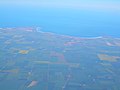
Aerial view of Moonta, looking west into Spencer Gulf
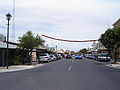
Shops along George Street, Moonta

Moonta Railway Station

Former Bank of South Australia

Post office

Moonta Uniting Church
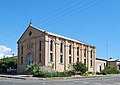
Former church
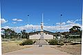
War Memorial

Royal Hotel, Moonta

Moonta Coastline
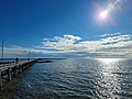
Moonta Jetty

Moonta Jetty Stairs


References[]
- ^ Australian Bureau of Statistics (27 June 2017). "Moonta". 2016 Census QuickStats. Retrieved 25 January 2018.

- ^ "Moonta, South Australia (Postcode)". postcodes-australia.com. Retrieved 7 April 2016.
- ^ Jump up to: a b c "Property Location Browser (Search: Moonta, LOCB)". Government of South Australia. Retrieved 1 February 2016.
- ^ Narungga (Map). Electoral District Boundaries Commission. 2016. Retrieved 1 March 2018.
- ^ Jump up to: a b "Federal electoral division of Grey" (PDF). Australian Electoral Commission. Retrieved 24 July 2015.
- ^ "Monthly climate statistics: Summary statistics KADINA AWS (nearest station)". Commonwealth of Australia , Bureau of Meteorology. Retrieved 6 April 2016.
- ^ "Kadina". District Council of the Copper Coast. Retrieved 26 May 2016.
- ^ "South Australia's Copper Coast: The secret holiday spot that offers the best of Cornwall, only better". Herald Sun. 7 October 2014. Retrieved 26 May 2016.
- ^ "Moonta (SSC)". 2011 Census Quick Stats. Australian Bureau of Statistics. Retrieved 7 June 2016.
- ^ "Moonta (UCL)". 2011 Census Quick Stats. Australian Bureau of Statistics. Retrieved 7 June 2016.
- ^ "Copper Coast Market Profile" (PDF). 2018. Copper Coast Council. Retrieved 6 July 2018.
- ^ Jump up to: a b "Moonta". Sydney Morning Herald. 8 February 2004. Retrieved 18 May 2016.
- ^ "Place Names of South Australia: Moonta". State Library of South Australia. Retrieved 18 May 2016.
- ^ "Mining towns of the Copper Coast give up haunting secrets". Sunshine Coast Daily. 18 December 2012. Retrieved 26 May 2016.
- ^ Wiltshire, Rex. Copper to Gold: A History of Wallaroo South Australia 1860–1928. Wakefield Press. p. 1.
- ^ "Baudin's Voyage: Published Accounts". State Library of South Australia. Retrieved 26 May 2016.
- ^ http://www.catalog.slsa.sa.gov.au:80/record=b2175295~S1 | Map of route.
- ^ State Library of S.A. Archival Maps, C 223, Outsize 6.
- ^ Register, 9 May 1840, p.5
- ^ "Moonta". Copper Coast Council. Retrieved 26 May 2016.
- ^ "Yorke's Peninsula". South Australian Register. XXXII (6844). South Australia. 13 October 1868. p. 3. Retrieved 20 November 2018 – via National Library of Australia.
- ^ "Search result(s) for Moonta, Gtwn". Property Location Browser. Government of South Australia. Archived from the original on 12 October 2016. Retrieved 26 May 2016.
- ^ Jump up to: a b "The Horse Tramways of the Moonta District" (PDF). Journal of Australian Tramway Museums (190): 7–8. October 1980.
- ^ "Meeting at Moonta". The Kadina and Wallaroo Times (SA : 1888 – 1954). SA: National Library of Australia. 12 July 1890. p. 2. Retrieved 17 October 2013.
- ^ For a discussion of the development of "Cornishness" see Philip Payton Making Moonta: The Invention of ‘Australia’s Little Cornwall, Exeter, University of Exeter Press, 2007 ISBN 978-0-85989-796-9 paperback ISBN 978-0-85989-795-2
- ^ "Area History". National Trust of South Australia, Moonta Branch. Retrieved 26 May 2016.
- ^ Jump up to: a b Drew, G. J. "Notes on the Moonta-Wallaroo Mining District" (PDF). South Australian Mining History. Retrieved 19 May 2016.
- ^ "All Saints Anglican Church". South Australian Heritage Register. Department of Environment, Water and Natural Resources. Retrieved 17 May 2016.
- ^ "Masonic Hall (Duke of Edinburgh Lodge No. 16)". South Australian Heritage Register. Department of Environment, Water and Natural Resources. Retrieved 17 May 2016.
- ^ "Dwelling (former Bank of South Australia Moonta Branch, later Union Bank)". South Australian Heritage Register. Department of Environment, Water and Natural Resources. Retrieved 17 May 2016.
- ^ "Former Moonta School of Mines (previously Baptist Church) and Fence". South Australian Heritage Register. Department of Environment, Water and Natural Resources. Retrieved 17 May 2016.
- ^ "Shop (former Moonta Railway Station)". South Australian Heritage Register. Department of Environment, Water and Natural Resources. Retrieved 17 May 2016.
- ^ "About Us". Kernewek Lowender. Retrieved 26 May 2016.
- ^ "Attractions". National Trust of South Australia, Moonta Branch. Retrieved 26 May 2016.
- ^ "Moonta Tourist Office". National Trust of South Australia, Moonta Branch. Retrieved 26 May 2016.
- ^ "Goyder electorate boundaries as of 2014". ELECTORAL COMMISSION SA. Retrieved 23 July 2015.
External links[]
| Wikimedia Commons has media related to Moonta, South Australia. |
- Towns in South Australia
- Yorke Peninsula
- Cornish-Australian culture
- Tourist attractions in South Australia
- Mining towns in South Australia