Marion Bay, South Australia
| Marion Bay South Australia | |||||||||||||||
|---|---|---|---|---|---|---|---|---|---|---|---|---|---|---|---|
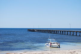 Jetty at Marion Bay | |||||||||||||||
 Marion Bay | |||||||||||||||
| Coordinates | 35°14′31″S 136°58′41″E / 35.241867°S 136.978179°ECoordinates: 35°14′31″S 136°58′41″E / 35.241867°S 136.978179°E[1] | ||||||||||||||
| Population | 172 (2016 census)[2] | ||||||||||||||
| Established | 1872[citation needed] | ||||||||||||||
| Postcode(s) | 5575[3] | ||||||||||||||
| Location | 151 km (94 mi) SW of Adelaide | ||||||||||||||
| LGA(s) | Yorke Peninsula Council | ||||||||||||||
| Region | Yorke and Mid North[4] | ||||||||||||||
| County | Fergusson[1] | ||||||||||||||
| State electorate(s) | Narungga[5] | ||||||||||||||
| Federal Division(s) | Grey[6] | ||||||||||||||
| |||||||||||||||
| |||||||||||||||
| Footnotes | Location[3] Adjoining localities[1] | ||||||||||||||

Marion Bay is a small township in the Australian state of South Australia at the southern tip of the Yorke Peninsula. At the 2016 census, Marion Bay had a population of 172.[2] Historically, it formed part of Narungga lands.[citation needed]
Description[]
It is surrounded by beaches and is the gateway to the Innes National Park.[citation needed] The close proximity of the beach and cliffs have popularized Marion Bay as a fishing destination, with Brown Beach in the nearby Innes National Park being particularly famous among recreational fisherman as a picturesque fishing destination.[citation needed]
Water supply[]
In 2008, a desalination plant was commissioned to meet the water demands of the summer tourist season. A 60 kL/d sea water reverse osmosis plant now supplies the local caravan park, residents and businesses. The plant was commissioned in response to declining bore water quality and associated problems of corrosion. The plant was designed and constructed by .[8]
Governance[]
Marion Bay is located within the federal Division of Grey, the state electoral district of Narungga and the local government area known as the Yorke Peninsula Council.[6][5][1]
See also[]
Notes and references[]
- ^ Jump up to: a b c d "Search results for 'Marion Bay, LOCB' with the following datasets being selected - 'Suburbs and Localities', 'Counties', 'Local Government Areas' and 'Gazetteer'". Government of South Australia. Retrieved 5 November 2018.
- ^ Jump up to: a b Australian Bureau of Statistics (27 June 2017). "Marion Bay". 2016 Census QuickStats. Retrieved 2 February 2018.

- ^ Jump up to: a b "Postcode for Marion Bay, South Australia". Postcodes Australia. Retrieved 8 January 2016.
- ^ "Yorke and Mid North SA Government region" (PDF). The Government of South Australia. Retrieved 28 April 2017.
- ^ Jump up to: a b Narungga (Map). Electoral District Boundaries Commission. 2016. Retrieved 1 March 2018.
- ^ Jump up to: a b "Federal electoral division of Grey" (PDF). Australian Electoral Commission. Retrieved 24 July 2015.
- ^ Jump up to: a b c "Summary statistics STENHOUSE BAY". Bureau of Meteorology, Government of Australia. Retrieved 8 January 2016.
- ^ "Drinking water for a seaside tourism community". osmoflo. Retrieved 8 January 2016.
External links[]
| Wikimedia Commons has media related to Marion Bay, South Australia. |
| show Coastal bays and inlets of South Australia |
|---|
This South Australia geography article is a stub. You can help Wikipedia by . |
- Towns in South Australia
- Yorke Peninsula
- Coastal towns in South Australia
- Bays of South Australia
- 1872 establishments in Australia
- Investigator Strait
- Beaches of South Australia
- South Australia geography stubs