Mount Berlin
| Mount Berlin | |
|---|---|
 | |
| Highest point | |
| Elevation | 3,478 m (11,411 ft) |
| Coordinates | 76°S 136°W / 76°S 136°W[1] |

Mount Berlin is a 3,478 metres (11,411 ft) high glacier-covered volcano in Marie Byrd Land, Antarctica, 210 kilometres (130 mi) from the Amundsen Sea. It is a c. 20-kilometre-wide (12 mi) mountain with parasitic vents that consists of two coalesced volcanoes; Berlin proper with the 2 kilometres (1.2 mi) wide Berlin Crater and Merrem Peak with a 2.5 by 1 kilometre (1.55 mi × 0.62 mi) wide crater, 3.5 kilometres (2.2 mi) away from Berlin. Trachyte is the dominant volcanic rock and occurs in the form of lava flows and pyroclastic rocks. It has a volume of 2,000 km3 (500 cu mi) and rises from the West Antarctic Ice Sheet. It is part of the Marie Byrd Land Volcanic Province.
The volcano began erupting during the Pliocene and was active into the late Pleistocene-Holocene. Several tephra layers encountered in ice cores all over Antarctica - but in particular at Mount Moulton - have been linked to Mount Berlin, which is the most important source of such tephras in the region. The tephra layers were formed by explosive eruptions/Plinian eruptions that generated high eruption columns. Presently, fumarolic activity occurs at Mount Berlin and forms ice towers from freezing steam.
Geography and geomorphology[]
Mount Berlin lies in Marie Byrd Land, West Antarctica,[2] 100 kilometres (62 mi) inland[3] from the Hobbs Coast of the Amundsen Sea.[4] The volcano was studied during field trips in December 1940, November 1967, November-December 1977[5] and 1994–1995.[6] The volcano is named after Leonard M. Berlin, who led the 1940 research visit to the mountain.[5]
Mount Berlin emerges 2.1 kilometres (1.3 mi)[7] from the West Antarctic Ice Sheet[8][a] and rises to 3,478 metres (11,411 ft) above sea level,[2][11] making it the highest volcano in the Flood Range with slopes of about 12-13°.[12] Berlin Crater, a 2 kilometres (1.2 mi) wide summit crater[13] with a sharply defined margin,[14] lies at the top of Mount Berlin;[11] the highest point of the volcano lies by its southeastern rim.[15] Mount Berlin consists of two overlapping edifices; the other part of the volcano is Merrem Peak, 3.5 kilometres (2.2 mi) west-northwest.[12] Merrem Peak is c. 3,000 metres (9,800 ft) high and has a 2.5 by 1 kilometre (1.55 mi × 0.62 mi) wide crater at its summit.[16] These craters are aligned in east-west direction like other Flood Range calderas.[17] Mount Berlin has variously been described as a composite volcano, shield volcano or stratovolcano[18] with a volume of about 200 cubic kilometres (48 cu mi).[12] The entire edifice has a length of about 20 kilometres (12 mi).[19] The volcano is the western end of the Flood Range;[20] Wells Saddle separates it from Mount Moulton volcano farther east.[11]
The volcano is covered by glaciers, and thus only a few rocky outcrops occur on the mountain[21][22] although the volcano is considered to be well-exposed compared to other volcanoes in the region.[5] Monogenetic volcanoes on the northern flank of Mount Berlin have generated two outcrops of mafic lava and scoria,[23] one of which is found at Mefford Knoll[24][20] on a linear vent.[25] On the southeastern flank, a fiamme-rich ignimbrite crops out[23] and is correlated to a flank vent on the northeastern flank.[16] A ridge emanates northwestward from Merrem Peak, with Brandenberger Bluff at its foot.[11] Brandenberger Bluff is a 300 metres (980 ft) high outcrop of lava and tuff that formed phreatomagmatically; it was formerly interpreted as a subglacial hyaloclastite.[16] Other topographical locations on Mount Berlin are Fields Peak on the northern flank, Kraut Rocks at the west-southwestern foot, Walts Cliff on the northeastern flank and Wedemeyer Rocks at the southern foot.[11][20] The existence of tuyas has been reported from Mount Berlin.[26] Nonvolcanic features include incipient cirques on the northern and western side.[3]

Topographical map of Mount Berlin
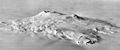
Aerial view of Mount Berlin


Geology[]
The Marie Byrd Land volcanic province features 18 central volcanoes and accompanying parasitic vents,[27] which form islands off the coast or nunataks in the ice.[2] Many of these volcanoes form distinct volcanic chains, such as the Executive Committee Range where volcanic activity has shifted at a rate of about 1 centimetre per year (0.39 in/year).[28] Such a movement is also apparent in the Flood Range, where activity migrated from Mount Moulton to Mount Berlin.[20] This movement appears to reflect the propagation of crustal fractures, as plate motion is extremely slow in the region.[29] Volcanic activity appears to take place in three phases, an early mafic phase, often followed by a second felsic phase. End-stage volcanism occurs in the form of small cone-forming eruptions.[30] Ignimbrites are rare in Marie Byrd Land; the outcrop on the southeastern flank of Mount Berlin is a rare exception.[23]
Activity began during the middle Miocene and continued into the later Quaternary, with argon-argon dating yielding ages as young as 8,200 years.[27] Four volcanoes in the Marie Byrd Land volcanic province - Mount Berlin, Mount Siple, Mount Takahe and Mount Waesche - were classified as "possibly or potentially active" by LeMasurier 1990, and active subglacial volcanoes have been identified on the basis of aerophysical surveys.[31]
The volcanic province is related to the West Antarctic Rift[27] which is variously interpreted as a rift[28] or as a plate boundary. The rift has been volcanically and tectonically active over the past 30-25 million years. The basement crops out near the coast and consists of Paleozoic rocks with intruded Cretaceous and Devonian granites which were flattened by erosion, leaving a Cretaceous erosion surface on which volcanoes rest.[32] The volcanic activity at Mount Berlin may ultimately relate to the presence of a mantle plume that is impinging onto the crust in Marie Byrd Land.[33]
Local deposits[]
Two[14] pyroclastic fallout deposits crop out in the crater rim, reaching thicknesses of 150 metres (490 ft). Merrem Peak crater also has outcrops of fallout deposits.[13] The Mount Berlin deposits reach thicknesses of over 70 metres (230 ft) close to the crater, diminishing to 1 metre (3 ft 3 in) at Merrem Peak. They were formed by pyroclastic fallout during eruptions, which mantled the topography and generated diverse fallout deposits when eruption characteristics changed. Tuff deposits containing lapilli and volcanic ash-rich pyroclastic deposits in the crater rim were erupted during hydromagmatic events.[23]
Some lava flows feature levees.[13] Some fall deposits in the crater rim were confused with lava flows in the past.[34] Hyalotuff,[35] obsidian and pumice have been recovered from Mount Berlin.[31] Both welded and unwelded, pyroclastic and tuffaceous breccias are present. They consist of lava bombs, lithic rocks, obsidian fragments and pumice.[23] Hyaloclastite occurs around the base of Mount Berlin.[36]
Composition[]
Most volcanic rocks of Mount Berlin define a trachyte suite, which features both comendite and pantellerite. Phonolite is less common.[23] Mafic rocks have been reported from flank vents,[37] basanite and hawaiite from Mefford Knoll,[13] benmoreite from the southeastern flank[16] at Wedemeyer Rocks,[20] phonotephrite from Brandenberger Bluff[35] and mugearite without any particular locality.[1]
Phenocrysts make up only a small portion of the volume and consist mostly of alkali feldspar, with subordinate apatite, fayalite, hedenbergite and opaque minerals. Benmoreite has more phenocrysts, which include anorthoclase, magnetite, olivine, plagioclase, pyroxene and .[38] Groundmass include basanite, mafic rocks, trachyte and .[39] Xenoliths are also recorded.[40]
The magma erupted by Mount Berlin appears to originate in the form of discrete small batches[41] rather than in one large magma chamber.[22] The composition of volcanic rocks varied between eruptions[23] and probably also during different phases of the same eruption.[42] Phonolite was erupted early during volcanic evolution and followed by trachyte during the Quaternary.[43] A long term trend in iron and sulfur of the tephras may indicate a long term trend towards more primitive magma compositions.[44]
Eruption history[]
Mount Berlin was active from the Pliocene into the Holocene.[1] The oldest parts are found at Wedemeyer Rocks[20] and Brandenberger Bluff and are 2.7 million years old. Activity then took place at Merrem Peak between 571,000 and 141,000 years ago; during this phase eruptions also occurred on the flanks of Mount Berlin. After 25,500 years ago it shifted to Mount Berlin proper[16] and the volcano grew by more than 400 metres (1,300 ft).[40] Over time, volcanic activity on Mount Berlin has moved in south-southeast direction.[35]
Eruptions of Berlin include both effusive eruptions, that emplaced cinder cones and lava flows,[15] and Plinian eruptions/[45] intense explosive eruptions,[46] which generated eruption columns up to 40 kilometres (25 mi) high. Such intense eruptions would have injected tephra into the stratosphere[b] and deposited it across the southern Pacific Ocean and the West Antarctic Ice Sheet.[48] The patterns of tephra deposition indicate that westerly winds transported tephra from Mount Berlin over Antarctica.[49] During the last 100,000 years Mount Berlin has been more active than Mount Takahe, the other major source of tephra in the West Antarctic, but activity at Berlin was episodic rather than steady.[50] The volcano underwent a surge in activity between 35,000/40,000 - 18,000/20,000 years ago.[51][44] Despite their size, the eruptions at Mount Berlin did not significantly impact climate.[52]
The eruption history of Mount Berlin is recorded in outcrops on Mount Berlin, in a blue-ice area on Mount Moulton,[c] 30 kilometres (19 mi) away,[54] at Mount Waesche, in ice cores[d][48] and in marine sediment cores[56] from the Southern Ocean.[57] A number of tephra layers found in ice cores all across Antarctica have been attributed to West Antarctic volcanoes and in particular to Mount Berlin.[58][59] Tephras deposited by this volcano have been used to date[e] ice cores,[63] establishing that ice at Mount Moulton is at least 492,000 years old and thus the oldest ice of West Antarctica.[64] So-called "megadust" layers in ice cores have also been linked to Mount Berlin and other volcanoes in Antarctica.[65]
Chronology[]
Among eruptions recorded at Mount Berlin are:
- Tephras in the Vostok ice cores deposited 406,000 years ago may come from Mount Berlin.[66]
- 492,400±9,700 years ago, recorded at Mount Moulton.[16] It may correspond to a 443,000±52,000 lava at Merrem Peak.[53]
- Cinder cones at Mefford Knoll have been dated to be 211,000±18,000 years old.[24] Potassium-argon dating there and at Kraut Rocks has produced ages of 630,000±30,000 and 620,000±50,000 years, respectively.[20]
- 141,600±7,500 years ago, recorded at Mount Moulton.[16] It may correspond to a 141,400±5,400 deposit at Merrem Peak.[53] A 141,700 years old tephra layer at Vostok has been related to this Mount Moulton tephra.[45]
- The Marine Tephra B, which has been identified in marine sediment cores and the Dome Fuji ice core, was erupted by Mount Berlin 130,700±1,800 years ago. It is used as a for the transition between marine isotope stage 6 and 5.[67]
- 118,700±2,500 years ago, recorded at Mount Moulton[16] and potentially also at Talos Dome.[68] Correlated deposits at Siple Ice Dome indicate that this eruption was intense and deposited tephra over large areas.[42]
- 106,300±2,400 years ago, recorded at Mount Moulton.[16]
- 92,500±2,000 and 92,200±900 years ago, as dated by argon-argon dating of its deposits around Mount Berlin.[54] A tephra layer in Dome C and Dome Fuji ice cores recovered during European Project for Ice Coring in Antarctica and dated to be 89,000-87,000 years old[69] has been attributed to this eruption on the basis of its composition.[54][70] The nature of the trachytic tephra layer indicates that it was produced during an intense, multiphase eruption[69] which may have led to compositional differences between deposits emplaced close and these emplaced far from the volcano.[54] Deposits from this eruption have also been found in the Amundsen Sea, the Bellingshausen Sea,[71] at a Vostok ice core and in marine sediments of the continental margin of West Antarctica ("tephra A"[72][73]).[51]
- A 28,500 year old tephra layer at Mount Erebus and in two ice cores of the West Antarctic Ice Sheet.[74]
- 27,300±2,300 years ago, recorded at Mount Moulton.[16]
- Ages of 25,500±2,000 years ago have been obtained from two lower welded pyroclastic units[34] that crop out within Mount Berlin crater.[40]
- Unwelded obsidian fallout units that crop out in Mount Berlin crater have been dated to be 18,200±5,800 years old.[34]
- 14,500±3,800 years ago, recorded at Mount Moulton.[16]
- Tephra layers found both close to and away from Mount Berlin and a lava flow appear to have been produced during an extended eruption about 10,500±2,500 years ago.[75]
- 7,768 BCE with an interval of 15 years, as dated in the Siple Dome A ice core.[76] A lava flow on Mount Berlin and tephras at Mount Moulton have a similar composition even if no exact match is found.[77]
A number of tephra layers between 18,100 and 55,400 years old, found in Siple Dome ice cores, resemble these of Mount Berlin,[78] as do tephras emplaced 9,346[77] and 2,067 BCE (interval 3.0 years) in the Siple Dome A ice core.[76] The marine "Tephra B" and "Tephra C" layers may also come from Mount Berlin but statistical methods have not supported such a relationship[79] at least for "Tephra B".[73] A 694±7 before present tephra layer found in the TALDICE ice core in East Antarctica may come from Mount Berlin or from Mount Melbourne[80] and may have been erupted at the same time as an eruption of The Pleiades.[81]
Last eruption and present-day activity[]
The date of the last eruption of Mount Berlin is unclear[82] but the Global Volcanism Program gives 8,350±5,300 years as the date of the last eruption.[83] Because of its Holocene activity,[84] the volcano is considered active[85] and several earthquakes have been recorded on Mount Berlin.[86]
Mount Berlin is geothermally active, the only volcano in Marie Byrd Land with such activity.[35] Steaming ice towers are found at Mount Berlin[31][25] on the western and northern rim of Berlin Crater.[87] Their existence was first reported in 1968; ice towers form when fumarole exhalations freeze in the cold Antarctic atmosphere[88] and are a characteristic trait of Antarctic volcanoes.[87] ASTER satellite imaging has not detected these fumaroles[89] presumably because they are hidden within the ice towers.[90] An over 70 metres (230 ft) long ice cave begins at one of these ice towers; temperatures of over 12 °C (54 °F) have been recorded on the cave floor.[34] These geothermal environments may host geothermal habitats similar to these in Victoria Land and at Deception Island, but Mount Berlin is remote and has never been studied in this sense.[91] It has been prospected for the potential to obtain geothermal power.[82]
See also[]
Notes[]
- ^ Which reaches an elevation of 1,400 metres (4,600 ft) here[9] and piles up against the volcano, resulting in a 800 metres (2,600 ft) height difference between the northern and southern flanks of Mount Berlin.[10]
- ^ A process facilitated by the low height of the tropopause over Antarctica.[47]
- ^ At Mount Moulton about 40 tephra layers linked to Mount Berlin have been identified[6] although some of these tephra layers may have been erupted by Mount Moulton.[37] Not all of these tephra layers correspond to known eruption deposits on Mount Berlin,[34] perhaps due to burial beneath younger eruptions; and not all eruptions of Mount Berlin are recorded at Mount Moulton, perhaps due to erosion by wind or due to winds transporting tephra elsewhere.[53]
- ^ Some of the tephra layers in the Byrd Station ice core were originally interpreted as being products of Mount Takahe[55]
- ^ Tephra layers from volcanoes can be used to date ice cores in Antarctica. Accurate dating is important for the correct interpretation of the wealth of environmental data in ice cores.[60] Traces of volcanic activity in ice cores allow reconstructions of the effect that volcanic activity had on climate.[61] Dating the age of ice also has implications for forecasting the future development of the West Antarctic Ice Sheet under anthropogenic global warming, as it has been hypothesized that this ice sheet collapsed during the Marine Isotope Stage 5 interglacial; finding ice older than this in the West Antarctic Ice Sheet would falsify the hypothesis.[62]
References[]
- ^ a b c LeMasurier et al. 1990, p. 151.
- ^ a b c Wilch, McIntosh & Dunbar 1999, p. 1564.
- ^ a b Lemasurier & Rocchi 2005, p. 57.
- ^ LeMasurier et al. 2003, p. 1057.
- ^ a b c LeMasurier et al. 1990, p. 233.
- ^ a b Dunbar & Kurbatov 2011, p. 1605.
- ^ Wilch, McIntosh & Panter 2021, p. 522.
- ^ Dunbar, McIntosh & Esser 2008, p. 796.
- ^ LeMasurier et al. 2003, p. 1060.
- ^ Swithinbank 1988, p. 127.
- ^ a b c d e Dunbar, McIntosh & Esser 2008, p. 797.
- ^ a b c LeMasurier et al. 1990, p. 229.
- ^ a b c d Wilch, McIntosh & Dunbar 1999, p. 1567.
- ^ a b Dunbar et al. 2021, p. 761.
- ^ a b Wilch, McIntosh & Dunbar 1999, p. 1575.
- ^ a b c d e f g h i j k Wilch, McIntosh & Dunbar 1999, p. 1570.
- ^ Global Volcanism Program, Photo Gallery.
- ^ LeMasurier et al. 1990, p. 4.
- ^ Lemasurier & Rocchi 2005, p. 59.
- ^ a b c d e f g LeMasurier et al. 1990, p. 226.
- ^ Smellie 2021, p. 34.
- ^ a b Dunbar, McIntosh & Esser 2008, p. 809.
- ^ a b c d e f g Wilch, McIntosh & Dunbar 1999, p. 1566.
- ^ a b Wilch, McIntosh & Dunbar 1999, p. 1568.
- ^ a b LeMasurier et al. 1990, p. 232.
- ^ Smellie 2021, p. 32.
- ^ a b c Narcisi, Robert Petit & Tiepolo 2006, p. 2684-2685.
- ^ a b LeMasurier & Rex 1989, p. 7223.
- ^ LeMasurier & Rex 1989, p. 7229.
- ^ LeMasurier & Rex 1989, p. 7225.
- ^ a b c Wilch, McIntosh & Dunbar 1999, p. 1565.
- ^ LeMasurier & Rex 1989, p. 7224.
- ^ Mukasa & Dalziel 2000, p. 612.
- ^ a b c d e Wilch, McIntosh & Dunbar 1999, p. 1572.
- ^ a b c d Wilch, McIntosh & Dunbar 1999, p. 1569.
- ^ LeMasurier et al. 1990, p. 150.
- ^ a b Dunbar, McIntosh & Esser 2008, p. 808.
- ^ LeMasurier et al. 1990, pp. 231–232.
- ^ Wilch, McIntosh & Dunbar 1999, pp. 1565–1566.
- ^ a b c Wilch, McIntosh & Dunbar 1999, p. 1571.
- ^ Dunbar, McIntosh & Esser 2008, p. 810.
- ^ a b Dunbar & Kurbatov 2011, p. 1611.
- ^ LeMasurier et al. 2011, p. 1178.
- ^ a b Iverson et al. 2016, p. 1.
- ^ a b Hillenbrand et al. 2008, p. 533.
- ^ Wilch, McIntosh & Dunbar 1999, p. 1576.
- ^ Hillenbrand et al. 2008, p. 519.
- ^ a b Wilch, McIntosh & Dunbar 1999, p. 1577.
- ^ Dunbar et al. 2021, p. 780.
- ^ Dunbar et al. 2021, p. 779.
- ^ a b Dunbar & Kurbatov 2011, p. 1612.
- ^ Narcisi, Proposito & Frezzotti 2001, p. 179.
- ^ a b c Wilch, McIntosh & Dunbar 1999, p. 1573.
- ^ a b c d Narcisi, Robert Petit & Tiepolo 2006, p. 2685.
- ^ Wilch, McIntosh & Dunbar 1999, pp. 1577–1578.
- ^ Dunbar et al. 2021, p. 760.
- ^ Narcisi et al. 2016, p. 71.
- ^ Dunbar & Kurbatov 2011, p. 1604.
- ^ Dunbar et al. 2021, p. 776.
- ^ Narcisi, Robert Petit & Tiepolo 2006, p. 2682.
- ^ Kurbatov et al. 2006, p. 1.
- ^ Wilch, McIntosh & Dunbar 1999, p. 1563.
- ^ Wilch, McIntosh & Dunbar 1999, p. 1578.
- ^ Wilch, McIntosh & Dunbar 1999, p. 1579.
- ^ Borunda et al. 2014, p. 1.
- ^ Narcisi & Petit 2021, p. 651.
- ^ Hillenbrand et al. 2021, p. 4.
- ^ Narcisi et al. 2016, p. 74.
- ^ a b Narcisi, Robert Petit & Tiepolo 2006, p. 2683.
- ^ Narcisi & Petit 2021, p. 659.
- ^ Iverson et al. 2017, p. 3.
- ^ Hillenbrand et al. 2008, p. 535.
- ^ a b Di Roberto, Del Carlo & Pompilio 2021, p. 641.
- ^ Narcisi & Petit 2021, p. 660.
- ^ Dunbar & Kurbatov 2011, p. 1610.
- ^ a b Kurbatov et al. 2006, p. 9.
- ^ a b Kurbatov et al. 2006, p. 14.
- ^ Dunbar & Kurbatov 2011, p. 1609.
- ^ Hillenbrand et al. 2008, p. 538.
- ^ Narcisi et al. 2012, p. 53.
- ^ Narcisi et al. 2012, p. 56.
- ^ a b Splettstoesser & Dreschhoff 1990, p. 120.
- ^ Global Volcanism Program, Eruptive history.
- ^ Dunbar et al. 2021, p. 759.
- ^ Kyle 1994, p. 84.
- ^ Lough et al. 2012, p. 1.
- ^ a b Global Volcanism Program, General Information.
- ^ LeMasurier & Wade 1968, p. 351.
- ^ Patrick & Smellie 2013, p. 481.
- ^ Patrick & Smellie 2013, p. 497.
- ^ Herbold, McDonald & Cary 2014, p. 184.
Sources[]
- Borunda, A.; Winckler, G.; Goldstein, S. L.; Kaplan, M. R.; McConnell, J. R.; Dunbar, N. W. (1 December 2014). "Local Sources for the "Megadust" Events at the WAIS Divide Ice Core". AGU Fall Meeting Abstracts. 41: A41F–3132. Bibcode:2014AGUFM.A41F3132B.
- Di Roberto, Alessio; Del Carlo, Paola; Pompilio, Massimo (2021). "Chapter 6.1 Marine record of Antarctic volcanism from drill cores". Geological Society, London, Memoirs. 55 (1): 641. doi:10.1144/M55-2018-49. ISSN 0435-4052.
- Dunbar, Nelia W.; Kurbatov, Andrei V. (1 June 2011). "Tephrochronology of the Siple Dome ice core, West Antarctica: correlations and sources". Quaternary Science Reviews. 30 (13): 1602–1614. Bibcode:2011QSRv...30.1602D. doi:10.1016/j.quascirev.2011.03.015. ISSN 0277-3791.
- Dunbar, Nelia W.; McIntosh, William C.; Esser, Richard P. (1 July 2008). "Physical setting and tephrochronology of the summit caldera ice record at Mount Moulton, West AntarcticaMount Moulton tephrochronology". GSA Bulletin. 120 (7–8): 796–812. doi:10.1130/B26140.1. ISSN 0016-7606.
- Dunbar, N. W.; Iverson, N. A.; Smellie, J. L.; McIntosh, W. C.; Zimmerer, M. J.; Kyle, P. R. (2021). "Chapter 7.4 Active volcanoes in Marie Byrd Land". Geological Society, London, Memoirs. 55 (1): 759–783. doi:10.1144/M55-2019-29. ISSN 0435-4052.
- "Berlin". Global Volcanism Program. Smithsonian Institution.
- Herbold, Craig W.; McDonald, Ian R.; Cary, S. Craig (2014), Cowan, Don A. (ed.), "Microbial Ecology of Geothermal Habitats in Antarctica", Antarctic Terrestrial Microbiology: Physical and Biological Properties of Antarctic Soils, Berlin, Heidelberg: Springer, pp. 181–215, doi:10.1007/978-3-642-45213-0_10, ISBN 978-3-642-45213-0, retrieved 2020-09-20
- Hillenbrand, C. -D.; Moreton, S. G.; Caburlotto, A.; Pudsey, C. J.; Lucchi, R. G.; Smellie, J. L.; Benetti, S.; Grobe, H.; Hunt, J. B.; Larter, R. D. (1 March 2008). "Volcanic time-markers for Marine Isotopic Stages 6 and 5 in Southern Ocean sediments and Antarctic ice cores: implications for tephra correlations between palaeoclimatic records". Quaternary Science Reviews. 27 (5): 518–540. Bibcode:2008QSRv...27..518H. doi:10.1016/j.quascirev.2007.11.009. ISSN 0277-3791.
- Hillenbrand, C. -D.; Crowhurst, S. J.; Williams, M.; Hodell, D. A.; McCave, I. N.; Ehrmann, W.; Xuan, C.; Piotrowski, A. M.; Hernández-Molina, F. J.; Graham, A. G. C.; Grobe, H.; Williams, T. J.; Horrocks, J. R.; Allen, C. S.; Larter, R. D. (1 April 2021). "New insights from multi-proxy data from the West Antarctic continental rise: Implications for dating and interpreting Late Quaternary palaeoenvironmental records". Quaternary Science Reviews. 257: 106842. Bibcode:2021QSRv..25706842H. doi:10.1016/j.quascirev.2021.106842. ISSN 0277-3791. S2CID 233578056.
- Iverson, N. A.; Dunbar, N. W.; McIntosh, W. C.; Kurbatov, A. (1 December 2016). "The tephrostratigraphy of Mt. Berlin volcano, Antarctica: Integrating blue ice tephra and ice core tephra records". AGU Fall Meeting Abstracts. 11: V11A–2752. Bibcode:2016AGUFM.V11A2752I.
- Iverson, Nels A.; Lieb-Lappen, Ross; Dunbar, Nelia W.; Obbard, Rachel; Kim, Ellen; Golden, Ellyn (13 September 2017). "The first physical evidence of subglacial volcanism under the West Antarctic Ice Sheet". Scientific Reports. 7 (1): 11457. Bibcode:2017NatSR...711457I. doi:10.1038/s41598-017-11515-3. ISSN 2045-2322. PMC 5597626. PMID 28904334. S2CID 205601012.
- Kurbatov, A. V.; Zielinski, G. A.; Dunbar, N. W.; Mayewski, P. A.; Meyerson, E. A.; Sneed, S. B.; Taylor, K. C. (2006). "A 12,000 year record of explosive volcanism in the Siple Dome Ice Core, West Antarctica". Journal of Geophysical Research. 111 (D12): D12307. Bibcode:2006JGRD..11112307K. doi:10.1029/2005JD006072.
- Kyle, Philip R., ed. (1994). "Volcanological and Environmental Studies of Mount Erebus, Antarctica". Antarctic Research Series. 66. doi:10.1029/ar066. ISBN 0-87590-875-6. ISSN 0066-4634.
- LeMasurier, Wesley E.; Choi, Sung Hi; Kawachi, Y.; Mukasa, Samuel B.; Rogers, N. W. (1 December 2011). "Evolution of pantellerite-trachyte-phonolite volcanoes by fractional crystallization of basanite magma in a continental rift setting, Marie Byrd Land, Antarctica". Contributions to Mineralogy and Petrology. 162 (6): 1175–1199. Bibcode:2011CoMP..162.1175L. doi:10.1007/s00410-011-0646-z. ISSN 1432-0967. S2CID 129243046.
- LeMasurier, Wesley E.; Futa, Kiyoto; Hole, Malcolm; Kawachi, Yosuke (1 December 2003). "Polybaric Evolution of Phonolite, Trachyte, and Rhyolite Volcanoes in Eastern Marie Byrd Land, Antarctica: Controls on Peralkalinity and Silica Saturation". International Geology Review. 45 (12): 1055–1099. Bibcode:2003IGRv...45.1055L. doi:10.2747/0020-6814.45.12.1055. ISSN 0020-6814. S2CID 130450918.
- LeMasurier, W. E.; Rex, D. C. (1989). "Evolution of linear volcanic ranges in Marie Byrd Land, West Antarctica". Journal of Geophysical Research. 94 (B6): 7223. Bibcode:1989JGR....94.7223L. doi:10.1029/JB094iB06p07223.
- LeMasurier, Wesley E.; Wade, F. Alton (18 October 1968). "Fumarolic Activity in Marie Byrd Land, Antarctica". Science. 162 (3851): 352. Bibcode:1968Sci...162..352L. doi:10.1126/science.162.3851.352. ISSN 0036-8075. PMID 17836656. S2CID 19337445.
- Lemasurier, Wesley E.; Rocchi, Sergio (1 March 2005). "Terrestrial record of post‐eocene climate history in marie byrd land, west antarctica". Geografiska Annaler: Series A, Physical Geography. 87 (1): 51–66. doi:10.1111/j.0435-3676.2005.00244.x. ISSN 0435-3676. S2CID 128880997.
- LeMasurier, W.E.; Thomson, J.W.; Baker, P.E.; Kyle, P.R.; Rowley, P.D.; Smellie, J.L.; Verwoerd, W.J., eds. (1990). "Volcanoes of the Antarctic Plate and Southern Oceans". Antarctic Research Series. 48. doi:10.1029/ar048. ISBN 0-87590-172-7. ISSN 0066-4634.
- Lough, A. C.; Barcheck, C. G.; Wiens, D. A.; Nyblade, A.; Aster, R. C.; Anandakrishnan, S.; Huerta, A. D.; Wilson, T. J. (1 December 2012). "Subglacial volcanic seismicity in Marie Byrd Land detected by the POLENET/ANET seismic deployment". AGU Fall Meeting Abstracts. 41: T41B–2587. Bibcode:2012AGUFM.T41B2587L.
- Mukasa, Samuel B.; Dalziel, Ian W. D. (1 April 2000). "Marie Byrd Land, West Antarctica: Evolution of Gondwana's Pacific margin constrained by zircon U-Pb geochronology and feldspar common-Pb isotopic compositions". GSA Bulletin. 112 (4): 611–627. Bibcode:2000GSAB..112..611M. doi:10.1130/0016-7606(2000)112<611:MBLWAE>2.0.CO;2. ISSN 0016-7606.
- Narcisi, Biancamaria; Proposito, Marco; Frezzotti, Massimo (2001). "Ice record of a 13th century explosive volcanic eruption in northern Victoria Land, East Antarctica". Antarctic Science. 13 (2): 174–181. Bibcode:2001AntSc..13..174N. doi:10.1017/S0954102001000268. ISSN 1365-2079. S2CID 131222366.
- Narcisi, Biancamaria; Robert Petit, Jean; Tiepolo, Massimo (1 November 2006). "A volcanic marker (92ka) for dating deep east Antarctic ice cores". Quaternary Science Reviews. 25 (21): 2682–2687. Bibcode:2006QSRv...25.2682N. doi:10.1016/j.quascirev.2006.07.009. ISSN 0277-3791.
- Narcisi, Biancamaria; Petit, Jean Robert; Delmonte, Barbara; Scarchilli, Claudio; Stenni, Barbara (23 August 2012). "A 16,000-yr tephra framework for the Antarctic ice sheet: a contribution from the new Talos Dome core". Quaternary Science Reviews. 49: 52–63. Bibcode:2012QSRv...49...52N. doi:10.1016/j.quascirev.2012.06.011. ISSN 0277-3791.
- Narcisi, Biancamaria; Petit, Jean Robert; Langone, Antonio; Stenni, Barbara (1 February 2016). "A new Eemian record of Antarctic tephra layers retrieved from the Talos Dome ice core (Northern Victoria Land)". Global and Planetary Change. 137: 69–78. Bibcode:2016GPC...137...69N. doi:10.1016/j.gloplacha.2015.12.016. hdl:2027.42/148354. ISSN 0921-8181.
- Narcisi, Biancamaria; Petit, Jean Robert (2021). "Chapter 6.2 Englacial tephras of East Antarctica". Geological Society, London, Memoirs. 55 (1): 649–664. doi:10.1144/M55-2018-86. ISSN 0435-4052.
- Patrick, Matthew R.; Smellie, John L. (2013). "Synthesis A spaceborne inventory of volcanic activity in Antarctica and southern oceans, 2000–10". Antarctic Science. 25 (4): 475–500. Bibcode:2013AntSc..25..475P. doi:10.1017/S0954102013000436. ISSN 0954-1020. S2CID 128905897.
- Smellie, John L. (2021). "Chapter 1.2 Antarctic volcanism: volcanology and palaeoenvironmental overview". Geological Society, London, Memoirs. 55 (1): 19–42. doi:10.1144/M55-2020-1. ISSN 0435-4052.
- Splettstoesser, John F.; Dreschhoff, Gisela A. M., eds. (1990). Mineral Resources Potential of Antarctica. Antarctic Research Series. 51. Washington, D. C.: American Geophysical Union. doi:10.1029/ar051. ISBN 978-0-87590-174-9.
- Swithinbank, Charles (1988). Williams, Richard S.; Ferrigno, Jane G. (eds.). "Satellite Image Atlas of Glaciers of the World-Antarctica". pubs.usgs.gov. U.S. Geological Survey Professional Paper 1386-B. Retrieved 2020-09-20.
- Wilch, T. I.; McIntosh, W. C.; Dunbar, N. W. (1 October 1999). "Late Quaternary volcanic activity in Marie Byrd Land: Potential 40Ar/39Ar-dated time horizons in West Antarctic ice and marine cores". GSA Bulletin. 111 (10): 1563–1580. Bibcode:1999GSAB..111.1563W. doi:10.1130/0016-7606(1999)111<1563:LQVAIM>2.3.CO;2. ISSN 0016-7606.
- Wilch, T. I.; McIntosh, W. C.; Panter, K. S. (2021-01-01). "Chapter 5.4a Marie Byrd Land and Ellsworth Land: volcanology". Geological Society, London, Memoirs. 55 (1): 515–576. doi:10.1144/M55-2019-39. ISSN 0435-4052. S2CID 233632723.
- Flood Range
- Polygenetic shield volcanoes
- Calderas of Antarctica
- Volcanoes of Marie Byrd Land
- Pliocene volcanoes
- Pleistocene volcanoes
- Holocene volcanoes