Mount Logan (Quebec)
This article is a rough translation from French. It may have been generated by a computer or by a translator without dual proficiency. |
| Mount Logan | |
|---|---|
| Mont Logan | |
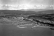
 The eastern slope of Mount Logan in 1923. | |
| Highest point | |
| Elevation | 1,150 m (3,770 ft) |
| Coordinates | 48°53′26″N 66°38′20″W / 48.89056°N 66.63889°WCoordinates: 48°53′26″N 66°38′20″W / 48.89056°N 66.63889°W[1] |
| Geography | |
| Country | Canada |
| Province | Quebec |
| Region | Bas-Saint-Laurent |
| Parent range | Chic-Choc Mountains (Notre Dame Mountains, Appalachian Mountains) |
| Topo map | NTS 22B15 Mont Logan |
| Geology | |
| Age of rock | 450 million years |
| Type of rock | metabasalt and metasedimentary rock |
| Climbing | |
| First ascent | 1844 by Alexander Murray and William Edmond Logan |
| Easiest route | Eastern slope |

Mount Logan is a mountain on the Gaspé Peninsula, in Quebec, Canada. It is part of the Chic-Choc Mountains, a massif of the Notre Dame Mountains in the Appalachian Mountains. At 1,150 metres (3,773 ft) above sea level, it is the highest point in the Bas-Saint-Laurent region and one of the few Quebec peaks over 1,100 metres (3,609 ft).
Its unusually steep northern flank is visible from Cap-Chat, on the estuary of Saint Lawrence. Its altitude and the exposure of its summit to winds and humid air masses from the Gulf of St. Lawrence make it one of Quebec's summits most prone to precipitation. Due to its physiography and unusual climate, Mount Logan is also the habitat of rare animal and plant species, such as the Gaspésie-Atlantique caribou and the griscom arnica.
Its particular topography, ancient geological composition and remarkable flora and fauna aroused the scientific community's interest beginning in the mid-19th century. In 1844 geologist William Edmond Logan was the first European to climb the mountain. He was looking for coal.
Despite abundant snow conditions favorable to mountain skiing, Mount Logan's remoteness has worked against the many efforts to develop recreational and tourism enterprises in the second half of the 20th century. Its protected status severely limits the possibility for other intensive activities such as forestry or broadcasting. Mount Logan now straddles the boundaries of Gaspésie National Park, the Réserve faunique de Matane (Matane Animal Reserve), the Fernald Ecological Reserve, floristic habitat of Mont-Logan and of the legal habitat of the Gaspé caribou.
Toponymy[]
Mount Logan is named for William Edmond Logan, against his will. Although already in use for some time, the name was formalized in 1898 by the Geographical Survey of Canada.[citation needed] The highest point in Canada, Mount Logan, is also named in his honor.[1]
Geography[]
Location[]
| External image | |
|---|---|
Mount Logan is in the unorganized area of Rivière-Bonjour, on the Gaspé Peninsula's northern flank in the province of Quebec in eastern Canada. It is 65 kilometres (40 mi) east of Matane, capital of the La Matanie Regional County Municipality, and 410 kilometres (250 mi) northeast of Quebec City, the provincial capital. The summit rises to about 1,150 metres (3,770 ft) in the Chic-Choc Mountains of the chain of the Notre Dame Mountains.
Topography[]

There are three physiographic divisions in the Mont Logan massif: in the north, the highlands, in the center, the mountain ridge of the Chic-Chocs; and, in the south, a plain.[2]
The piedmont highlands are made up of wooded valleys with an average altitude of 550 metres (1,800 ft). Streams and rivers flow through ravines up to 400 metres (1,300 ft).[2]
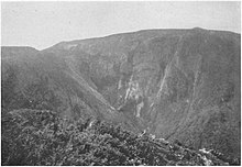
Mount Logan has a variegated terrain morphology, alternating gentle rounded and grassy slopes with steep cliffs. To the north, a steep escarpment makes it one of eastern Canada's highest peaks, with a height at the peak of 620 metres (2,030 ft).[3] This wall, whose height varies between 450 and 600 meters (1,480 and 1,970 ft), has a slope generally between 20 and 40°, even vertical in some places, and visible from several places along the coast of the estuary of Saint Lawrence, in particular Cap-Chat[2] and Sainte-Anne-des-Monts.[4] The wall's western portion, not as steep, is nonetheless more impassable than its eastern counterpart. The slopes of the southern flank of the massif are gentler; their elevation varies from 180 to 300 metres (590 to 980 ft), with a sloping distance of about one kilometer.[2]
The summit itself is a picturesque dome with an elevation of up to 1,150 metres (3,770 ft), set on a ridge of similarly elevated peaks (Mattawees, Fortin, Pembroke) interspersed with deep valleys.[2][4]
Geology[]
Mount Logan was formed about 450 million years ago, during the Lower Ordovician, Paleozoic era[5] During the Taconic orogeny, a lateral pressure exerted by other formations in the bedrock caused folds, then the increasing pressure caused the overlap; a bed load a few hundred metres thick was set up. To the north, the overlap fault of Lake Cascapedia marks the front of one of these folds. The southern edge is made up of the strike-slip faults zone known as the “South Schikshock” or “Brompton – Baie-Verte line”. This line separates the Taconian belt from the Acadian belt.[6] The Logan nappe consists of metabasalt and metasedimentary rocks.,[5] which are harder than the rocks of the surrounding formations, which erode faster, revealing the unusual relief of the Chic-Choc mountains, and more specifically of Mont Logan.[6]
Soundings show intrusions of the Devonian in the form of sill and dyke. This research also revealed a substantial presence of copper, talc and marl on the mountain.[2]
Climate[]
There is no station providing continuous climate data at the top of Mount Logan; a climate model makes it possible to estimate temperatures and precipitation from data from surrounding stations.[7]
The climate of the mountain is influenced by its altitude and its proximity to the Gulf of St. Lawrence.,[8] whose currents carry cold waters from the Arctic.[2] The average temperature at the top is around −3 °C (27 °F). Moisture condenses there more easily due to the lower pressure and temperatures at the summit. Thus, on an annual basis, the mountains receive some of the greatest amounts of precipitation in Quebec.[9] Episodes of rain, melting conditions, the formation of ice shells and numerous snowstorms during the winter combine to cause conditions conducive to avalanches, common on the cliffs of the mountain.[8]
The prevailing winds are from the west. At 31.9 kilometres (19.8 mi) east of Logan, on Mount Albert.,[Note 1] winds average 24 kilometres per hour (15 mph). Gusts of 250 kilometres per hour (160 mph) have been recorded.[9]
| Part of a series on |
| Weather |
|---|
 |
|
|
Fauna and flora[]
Mount Logan is primarily covered in fir forest with some white birch.[10] The preindustrial forest was dominated by mature conifers, but logging has changed that.[11] In particular the Hammermill company held cutting rights for an annual volume of wood of 72,000 cubic metres (2,500,000 cu ft) on the mountain.,[2] transforming the nature of the stands, now composed of young coniferous shoots bordering more hardwoods.[11] The regeneration cycle is slow: 30 to 60 years (950 to 1,890 Ms) are required for a stand dominated by balsam fir to mature.,[2] nearly twice as long as for most conifers.[12]

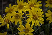
The altitude of the mountain and its exposure to the winds make it an excellent site for the vegetation of subalpine meadows. The western slope of the mountain and its summit are home to a large number of rare, threatened or vulnerable plant species, some of which are endemic to the Chic-Choc massif. The Ministry of the Environment and Fight Against Climate Change protect Arnica griscomii, Arnica lanceolata, the Athyrium distentifolium, Packera, , Dryopteris filix-mas, Festuca altaica, Norwegian gnaphale and Gaspé saxifrage.[10][13]
La Matanie Regional County Municipality also identifies in its land use plan the mountain as the habitat of many plants likely to be vulnerable, such as Rosy Cat's Foot, Allen's Buttercup, sagina, snow saxifrage, and Cerastium cerastoides[14]
Mount Logan is home to two vulnerable animal species. On the one hand, the eastern slope constitutes a habitat for Bicknell's thrush.[14] On the other hand, after having deserted it from the 1970s,[15] the herd of Gaspésie-Atlantique caribou frequents the mountain again.[13][14]
History[]
Logan's Expedition[]
In search of coal, William Edmond Logan explored the Gaspé for the first time in 1843, then returned there in 1844. On the boat taking them to Gaspé, the chemist Édouard Sylvestre de Rottermund, joking with Captain Walter Douglas, proposed to name "Logan" the highest mountain they could see off Cap-Chat, and which they intended to explore.[16] The geologist disapproved of this.[1][16]
Along with the Earl of Rottermund, the geologist Alexander Murray, two assistants and four Mi'gmaq guides, Logan and his eight acolytes left Cap-Chat on 5 July 1844, with the intention of reaching , then Baie des Chaleurs. The explorers first proceeded to the peaks visible from the coast in the north of the peninsula, then up the by canoe. They reached the base of the mountain on July 14. Four days later,[16] they become the first Europeans to reach the summit of Mount Logan;[1] they planted the Union Jack[16] there. Logan described the view in these terms:
From the highest peak we visited, the panorama was most magnificent. On the northern half of the circle, the waters of the St. Lawrence, dotted with ships and fishing boats, stretched left and right for as far as the eye could see [...].
Towards the east, a confusion of mountains and ravines belonging to the Monts Notre-Dame filled the horizon, and we assumed that a summit, which showed a patch of snow, might have been higher than the point at which we were standing. found. Several of the peaks that we could see were bare rock [...].
Towards the south, an undulating sea of parallel ridges occupied the picture [...].
On lower elevations, spruce trees mingled with birch trees, and tree sizes increased as elevation decreased. After confinement in the forest below, the high altitude vegetation hit us hard and satisfied us greatly. Large expanses of open meadow appeared to us on all sides except the north. Wide slopes to the east, south and west were carpeted with the most lush shoots and a diversity of ferns, from which the hills sometimes looked like park landscapes or works of art as if the distribution was arranged for an ornamental purpose and often producing, with peaks, ravines and a distant horizon, landscapes of the most grandiose.[16]
Logan's expedition explored the surroundings, then crossed a pass to finally reach the Cascapedia River, which they surveyed in detail. They reached Chaleur Bay on 6 September 1844.[16]
Fernald's Expeditions[]
Many academic publications are interested in the Chic-Chocs massif during the 1920s. Noting the paucity of knowledge on the mountain, the botanist Merritt Lyndon Fernald tried to reach the summit of Mount Logan with the intention of describe the flora. His work was inspired by the Laurentian herbarium of the botanist John Macoun,[17] as well as physiographic studies by geologists William Edmond Logan, Arthur Coleman and Frederick J. Alcock.
In 1922, accompanied by the botanist Arthur Stanley Pease and guide Joseph Fortin, Fernald tried to find the trail that Logan had taken to the summit. The mountain is practically unknown to the locals: researchers are trying several routes to reach the top. A series of thunderstorms put an end to their first expedition. The following year, Fernald formed a team of seven botanists, including Pease, James Franklin Collins, Carroll William Dodge, Ludlow Griscom, Kenneth Kent Mackenzie and Lyman Bradford Smith. Scientists find plants on the mountain characteristic of the Canadian Arctic and Western Cordillera, never before seen so far south and east.[4] In short, the expedition identifies 3000 plants; arctic, alpine and endemic. Fernald explains these findings by hypothesizing that Mount Logan and the surrounding peaks were nunataqs during the last ice age.[18]
The names of the neighboring Collins mountains.[19] and Dodge,[20] arnica de Griscom and Fernald ecological reserve recall the visit of botanists in the 1920s.[21] Fernald's work in Gaspésie inspired Brother Marie-Victorin to form his Laurentian Flore.[17] Marie-Victorin even says of Fernald that he is her "botanical father".[18]
Focal point for television broadcasting in Eastern Canada[]
| External image | |
|---|---|
As television spreads to Quebec homes, a race for the rise of the Chic-Chocs is emerging between different broadcasting groups.[22] At the beginning of 1961, Télévision Transgaspésienne (TVTG, affiliated with Télé-Métropole[23]) and the Compagnie de broadcasting de Matane (CKBL) are both demanding from the Board of Broadcast Governors a broadcasting license on the highest summits of the Gaspé.[22] TVTG had obtained from the Quebec State a emphyteutic lease for the installation of an antenna at the top of Mount Jacques-Cartier;[22] CKBL, which was ultimately licensed, instead obtained permission from the government to occupy the Logan summit.[24]
Led by the technical director of the station Yvan Fortier.[25](which prepared them since 1959[26]), the work is entirely carried out between June and October 1961.[25] We build a 6 miles (10 km) road connecting Saint-Octave-de-l'Avenir to the transmitter, a 260 feet (79 m), buildings and a generator.[25][27] The equipment installed is rudimentary[28] In order to ensure an uninterrupted television signal in Gaspésie, on the and Labrador, three technicians and their families are assigned in rotation to residence at the base of the transmitter, supplied with food and oil first by helicopter,[28] then by .[25]
Although it is most powerful,[29] the signal is ill-suited to the Gaspé topography and the transmitter is difficult to make profitable.[30] In the meantime, at the foot of the mountain, the village of Saint-Octave-de-l'Avenir is abandoned and supplies must henceforth be obtained from Cap-Chat, via the valley of the . As soon as CKBL was acquired in 1972 by the Société Radio-Canada (SRC), it was planned to put the transmitter off-wave.[31] Operation "Descent of Mount Logan" was announced in 1977 by the engineers of the SRC,[28] and part of the installations were dismantled the following year.[29] The remaining buildings and the main pylon were finally demolished in 2011.[32]
In 2007, Radio-Canada, still owner of the summit, tried to divest itself of its land. The blocks the sale; study reveals soil contamination with diesel which once powered.[32] generators. Work worth 400000 began in 2014 to build a biotter ( device), but the process must be spread over a period of at least six years,[33] due to the harshness of the climate, the isolation of the site and the ecological sensitivity.[32]
The summit serves in 2019 as a radio transmission site for the operations of the (SOPFEU), the National Integrated Radiocommunication Network (RENIR) of the , and de Télécommunications de l'Est, a local operatoré[34] Radio-Canada remains the owner of block B of .[35][36]
Attempts to develop a ski area[]
In order to make their Mont Logan transmitter profitable, the owners of CKBL plan to develop the ski potential of the mountain as soon as it is put into service.[27][30] They call on Ernie McCullogh, ski trainer, to organize an exploration expedition with industrialists from Matane.,[37] then a cinematographic expedition to demonstrate this potential in the spring of 1964.[38][39] The mountain is praised for its abundant and persistent snow.,[27][39] in addition to the multiple exploitable slopes.[40] The site is the training ground for the Canadian delegation of the Interski[41] McCullogh even promises to make Mount Logan the training site for the Canadian alpine ski team.[42] The mountain is regularly compared to Val-d'Isère.[39][42][43]
The multiple expeditions attract the attention of politicians[44] and financiers torontois,[40][43] which want government guarantees before investing.[27] We are planning the development of a ski resort that can accommodate up to 5000 escorted by five chairlifts, and lodged in nearby towns or in a hotel with a capacity of 500 clients.[40][43] The estimated cost of the station is first US$1,500,000,[40][42] then US$3,000,000,[40][43] to be then estimated between US$7,000,000 and US$10,000,000.[44] The Bureau d'aménagement de l'Est du Québec takes up the;[30][45] the Ministry of Lands and Forests entrusts with the task of studying ski development projects for the highest peaks of the Chic-Chocs.[46] There are plans to build an elaborate network of access roads and an airport large enough to accommodate airliners;[46] the bill climbs to 40000000. However, no public investment is made in this direction. The government prohibits the showing in Quebec of films about McCullogh's expeditions, and the site of Mont Sainte-Anne, closer to Quebec and Montreal, is preferred for the establishment of a ski resort of international caliber.[47]
The project was still discussed in the mid-1970s with a heli-ski formula, requiring lighter immobilizations. However, the Quebec government refuses to inject money into it.[27] A heli-ski resort was operated by businessmen from the region between 1985 and 1990.,[48][49] but their efforts to enhance the mountain are weighed down by competition from Massif de Charlevoix.[47]
In 2002, the Société des establishments de plein air du Québec preferred Mont Jean-Yves-Bérubé to Mont Logan for the construction of a mountain inn of great luxury, the Chic-Chocs mountain inn, where guided ski touring services are offered [50][51]
Activities[]

Mountain skiing[]
If attempts to establish the perennial infrastructure necessary for a ski resort have failed, mountain skiing is still practiced on Mount Logan. The manager of the Parc national de la Gaspésie, the Société des establishments de plein air du Québec, provides light equipment for the practice of mountain skiing on Mont Logan and the surrounding peaks: beacons, shelters, refuges and depot emergency equipment.[52]
Although the slopes of the southern slope are of intermediate class, the journey nevertheless represents a challenge even for advanced skiers. Requiring two to three days of hiking,[53] the approach to the summit from Saint-Octave-de-l'Avenir is via a long trail of 35 kilometres (22 mi) whose positive elevation is close to 800 meters (2,600 ft)[54]
From the Chic-Chocs mountain inn, accessible from Cap-Chat by snowmobile (by reservation only), it is possible to use the services of a guide to get to Mont Jean-Yves Bérubé at Mont Logan.[55]
Hiking[]
The ascent of Mount Logan is achievable when the ground is clear of snow, from late June to late September. The trails are isolated and little frequented.[56][57][58] The ascent time generally requires an overnight stay in a refuge.[56] The western approach is via the from the valley, and the round trip requires two to three days of hiking.[59] From the east, it is possible to take a or a steep path.[57] In order to shorten the route, it is also possible to take a shuttle from Cap-Chat.[59] or the Mont Albert.[56]
Environmental protection[]
Part of the Gaspé National Park, most of the mountain was protected as early as 1937.[60] In order to ensure increased protection of the flora and fauna particular to the Chic-Chocs massif, the activities of industrial forestry and are prohibited in the park from 1977.[15] Belonging to the Société Radio-Canada, the summit of the mountain is not part of the Parc de la Gaspésie. However, it is planned to transfer it to the Quebec government once the soil has been decontaminated from the diesel found there.[32]
Integrated into the since 1995, the eastern slope of the mountain benefits from additional protection in order to ensure the survival of rare and threatened plant specimens found there.[10] The part of the western slope excluded from the Parc de la Gaspésie is included in the .[61] Immediately to the northwest, the provides full protection of the escarpment north of the Collins, Mattawees and Fortin summits.[62]
The entire mountain is included in the of the Gaspé caribou.[11]
Notes and references[]
Notes[]
- ^ Similar in elevation and latitude to Mount Logan.
See also[]
- Chic-Choc Mountains
- Geography of Quebec
- La Matanie Regional County Municipality
- Gaspésie National Park
External links[]
- ^ Jump up to: a b c d "Mont Logan". Commission de Toponymie du Québec. Retrieved 28 February 2018..
- ^ Jump up to: a b c d e f g h i Cyril R. Mattinson (1958). McGill University (ed.). The geology of the Mount Logan area, Gaspé, Quebec. Retrieved 2020-02-05..
- ^ "Eastern Canada Peaks with 2000 feet of Prominence - Peakbagger.com". peakbagger.com. Retrieved 2019-01-06..
- ^ Jump up to: a b c J. Franklin, Collins; Merritt L. Fernald (1925). "The Region of Mount Logan, Gaspé Peninsula". Geographical Review. 15 (1): 84–91. doi:10.2307/207917. ISSN 0016-7428. JSTOR 207917. Retrieved 2020-02-05..
- ^ Jump up to: a b "SIGÉOM | Geomining information system | Interactive map". sigeom.mines.gouv.qc.ca. Retrieved 2019-07-31..
- ^ Jump up to: a b Benoît Vigneau; Bernard Hétu; Antoine Morissette; Guglielmo Tita; Marc-Olivier Mass (2011). Center for research on island and maritime environments (ed.). Inventory of the geomorphological heritage of the MRC de la Haute-Gaspésie and identification of geotourism valuation strategies (in French). p. 355. ISBN 978-2-9810817-4-2. OCLC 813670770. Retrieved 2020-02-24..
- ^ G.-Oscar Villeneuve (2005-04-12). "Climatic similarities of the Laurentian and Gaspé massifs". Cahiers de géographie du Québec. 12 (25): 49–66. doi:10.7202/020786ar. Retrieved 2020-02-05..
- ^ Jump up to: a b Stéphanie-Caroline Lemieux (2007). Université de Sherbrooke (ed.). Mapping and classification of the terrain with avalanche potential in Chics-Chocs, Quebec, Canada, using a geographic information system. ISBN 978-0-494-49531-5. Retrieved 2020-02-05..
- ^ Jump up to: a b Société des establishments de plein-air du Québec. "Portrait of the park" (in French). Parc national de la Gaspésie. Retrieved 2020-02-05..
- ^ Jump up to: a b c "Floristic habitat of Mont-Logan". Ministry of the Environment, Sustainable Development and Climate Change. Retrieved 2019-01-08..
- ^ Jump up to: a b c Gaspésie Caribou Recovery Team (2018). Recovery plan for the caribou (Rangifer tarandus caribou) population of the Gaspé - 2019-2029 (PDF) (in French). p. 59. ISBN 978-2-550-79322-9..
- ^ Ministry of Natural Resources. "Sapin balsamier (SAB)". Le guide sylvicole du Québec (in French). Retrieved 2020-03-02.
- ^ Jump up to: a b Bernard Tardif; Gildo Lavoie; Yves Lachance (2005). Atlas de la biodiversité du Québec: Les espèces menacées ou vulnérables [Atlas of biodiversity in Quebec: threatened or vulnerable species]. Government of Quebec. p. 60. ISBN 2-550-44174-5.
- ^ Jump up to: a b c Regional county municipality of Matane (May 9, 2001). Revised development plan: the complementary document. Matane..
- ^ Jump up to: a b Édith Cadieux; Jean-Philippe Guay (May 2010). Nature Québec (ed.). For better protection of the Gaspésie caribou (PDF). p. 14. ISBN 978-2-923731-07-0.
5
. - ^ Jump up to: a b c d e f Bernard James Harrington (1883). Dawson Brother Publishers (ed.). Life of Sir William E. Logan, Kt., LL.D., FRS, FGS, & c., first director of the Geological Survey of Canada: chiefly compiled from his letters, journals and reports. Montréal. p. 432..
- ^ Jump up to: a b Marcel Raymond (May 1950). "Presentation of the Marie-Victorin to Professor M.-L. Fernald". Le Devoir. p. 12.
- ^ Jump up to: a b Luc Sirois; Julien Goyette (2019). "n the footsteps of botanist Merritt Lyndon Fernald". Magazine Gaspésie. 56 (2). pp. 5–7. ISSN 1207-5280. Retrieved 2020-02-24..
- ^ "Mont Collins". Commission de toponymie du Québec. Retrieved 2020-02-24..
- ^ "Mont Dodge". Commission de toponymie du Québec. 2020-02-24.
- ^ "Fernald Ecological Reserve". Commission de toponymie du Quebec. Retrieved 2019-01-06..
- ^ Jump up to: a b c La Presse Canadienne (April 13, 1961). "Disputes in rival companies in the Gaspé". La Presse. p. 44.
- ^ Raymond Guérin (October 7, 1961). "All Gaspé!". La Presse. p. 13.
- ^ "Regional News". L'Action Catholique. April 24, 1961. p. 15.
- ^ Jump up to: a b c d "CBGAT Canal 9 Matane". Television Program Here Radio-Canada. 8 (3). January 12, 1974. p. 7.
- ^ Gilles Gagné (2008-09-05). "60 years of radio in Matane". Le Soleil. Retrieved 2019-01-06.
- ^ Jump up to: a b c d e Georges Guy (March 1975). "Do you know the Chic-Chocs?". The Farmers' Bulletin. p. 109.
- ^ Jump up to: a b c Gilles Constantineau (December 16, 1976). "Radio-Canada descends Mont Logan". Le Devoir. p. 12.
- ^ Jump up to: a b "CKBL-TV | History of Canadian Broadcasting". www.broadcasting-history.ca. Retrieved 2019-01-07.
- ^ Jump up to: a b c Jacques De Guise (1965). Bureau d'aménagement de l'Est du Québec (ed.). Technical appendix to the 1966-1972 development plan for the Bas-Saint-Laurent, the Gaspésie and the Islands-de-la-Madeleine: Information media within the pilot territory. Mont-Joli. p. 229.
53
- ^ Nancy Ross (December 9, 1976). "Communications in Gaspé in a pitiful state". Le Soleil. pp. B2.
- ^ Jump up to: a b c d Steven Guiton (August 22, 2013). CBC-Radio-Canada (ed.). Remediation of the Mount Logan site (PDF). p. 10. Archived from the original (PDF) on 2019-01-10.
- ^ Corporate communications CBC/Radio-Canada, ed. (2016). Annual report 2014-2015 (PDF). Ottawa. p. 141.
106
- ^ "Radio Frequency Search By Geographical Area". Industry Canada. Retrieved 2019-01-07.
- ^ "Rivière-Bonjour - Graphic matrix". Groupe de géomatique AZIMUT inc. Retrieved 2019-01-09.
- ^ "Land register of Quebec online". Ministry of Energy and Natural Resources. Retrieved 2019-01-09.
- ^ Andrée Gauthier (April 19, 1963). "For tourist development". The Progress of the Gulf. p. 29..
- ^ Andrée Gauthier (April 17, 1964). "Expedition to Mount Logan". The Progress of the Gulf. p. 7..
- ^ Jump up to: a b c Claude Larochelle (May 14, 1964). "There is still snow at Mont Logan". Le Soleil. p. 31..
- ^ Jump up to: a b c d e Claude Turcotte (April 16, 1964). "Mont Logan would soon become the site of a major ski center". Le Soleil. p. 56..
- ^ "The team Canadian Interski on the slopes". Le Devoir. 24 November 1964. p. 18..
- ^ Jump up to: a b c Andrée Gauthier (25 October 1963). "Mount Logan, Val d 'Isère canadienne". The Progress of the Gulf. p. 6..
- ^ Jump up to: a b c d Jean La Bessière (January 21, 1965). "McCulloch: $3 million would be enough to develop Mount Logan". La Presse. p. 43..
- ^ Jump up to: a b Claude Larochelle (May 31, 1965). "Cubs and Dodgers will help Quebec". Le Soleil. p. 20..
- ^ Georges Guy (December 31, 1965). "For die-hard skiers: the Gaspé Shickshocks". La Presse. p. 3..
- ^ Jump up to: a b Robert Rioux (2 February 1965). "Project for a $40,000,000 ski resort in the Gaspé". Le Soleil. p. 25..
- ^ Jump up to: a b André Dionne (May 13, 1985). "Idea deemed disturbing for other projects in Quebec". Le Soleil. p. 11..
- ^ André Dionne (May 13, 1985). "Mont Logan: another 2 weeks of skiing". Le Soleil. pp. A11..
- ^ "Mont Jean-Yves-Bérubé". Commission de toponymie du Québec. Retrieved 2019-01-07..
- ^ Lise Giguère (March 13, 2013). "Luxury at the top". Le Journal de Montréal. Retrieved 2019-01-07..
- ^ Lise Giguère (2010-02-16). "Canoe - Escape - Auberge des Chic-Chocs in Gaspésie: luxury in the mountains". fr.canoe.ca. Retrieved 2019-01-07..
- ^ "General map of the park (winter)" (PDF). Parc national de la Gaspésie. 2016. Retrieved January 6, 2019..
- ^ Marie Tison (2014-02-12). "Chic-Chocs: snow and animals". La Presse (in French). Retrieved 2020-02-24..
- ^ "Mountain skiing - Les Chic-Chocs en autonomy". Tourisme Gaspésie (in French). Retrieved 2020-02-24..
- ^ Jerry Kobalenko (2016-08-04). "Chic-Chocs chic: Gaspé Peninsula". Canadian Geographic. Retrieved 2020-02-24..
- ^ Jump up to: a b c Alexandre Lauzon. "Mont Logan". Alexhike. Retrieved 2020-02-24..
- ^ Jump up to: a b "Mont Logan: Climbing, Hiking & Mountaineering". SummitPost. Retrieved 2020-02-05..
- ^ Christian Lévesque (23 June 2011). "Sentier international des Appalaches - La longue marche". Espaces. Retrieved 2020-02-24.
- ^ Jump up to: a b Anne Pelouas (2012-04-26). "A bridge between two peaks". Géo Plein Air (in French). Retrieved 2020-02-24..
- ^ Onésime Gagnon (March 20, 1937). "The government proposes to establish a national park north of Montreal". Le Canada. p. 14..
- ^ Société des establishments de plein-air du Québec (May 2019). "Réserve faunique de Matane: general map" (PDF). Sepaq.com. Retrieved February 24, 2020..
- ^ Environment and Fight against change climatiques Québec (2020). Gouvernement du Québec (ed.). "Fernald Ecological Reserve". www.environnement.gouv.qc.ca. Retrieved 2020-02-24..
- Appalachian summits
- Notre Dame Mountains
- One-thousanders of Quebec