Mount Vernon, Alabama
Mount Vernon, Alabama | |
|---|---|
 Location of Mount Vernon in Mobile County, Alabama. | |
| Coordinates: 31°5′35″N 88°0′40″W / 31.09306°N 88.01111°W | |
| Country | United States |
| State | Alabama |
| County | Mobile |
| Area | |
| • Total | 5.59 sq mi (14.49 km2) |
| • Land | 5.48 sq mi (14.20 km2) |
| • Water | 0.11 sq mi (0.29 km2) |
| Elevation | 30 ft (9 m) |
| Population (2020) | |
| • Total | 1,354 |
| • Density | 247.04/sq mi (95.38/km2) |
| Time zone | UTC-6 (Central (CST)) |
| • Summer (DST) | UTC-5 (CDT) |
| ZIP code | 36560 |
| Area code(s) | 251 |
| FIPS code | 01-52608 |
| GNIS feature ID | 0158031 |
| Website | http://www.mtvernonal.com/ |

Mount Vernon is a town in Mobile County, Alabama, United States. It is included in the Mobile metropolitan statistical area. It incorporated in 1959.[2] At the 2010 census the population was 1,574, up from 844 in 2000.
Geography[]
Mount Vernon is located at 31°5′35″N 88°0′40″W / 31.09306°N 88.01111°W (31.093170, -88.011209).[3] According to the U.S. Census Bureau, the town has a total area of 1.9 square miles (4.9 km2), of which 1.9 square miles (4.9 km2) is land and 0.53% is water.
Demographics[]
| Historical population | |||
|---|---|---|---|
| Census | Pop. | %± | |
| 1960 | 553 | — | |
| 1970 | 1,079 | 95.1% | |
| 1980 | 1,038 | −3.8% | |
| 1990 | 902 | −13.1% | |
| 2000 | 844 | −6.4% | |
| 2010 | 1,574 | 86.5% | |
| 2020 | 1,354 | −14.0% | |
| U.S. Decennial Census[4] 2013 Estimate[5] | |||
2000 census[]
At the 2000 census there were 844 people, 333 households, and 228 families in the town. The population density was 446.4 people per square mile (172.4/km2). There were 395 housing units at an average density of 208.9 per square mile (80.7/km2). The racial makeup of the town was 45.38% White, 52.96% Black or African American, 0.95% Native American, 0.24% from other races, and 0.47% from two or more races. 0.12% of the population were Hispanic or Latino of any race.[6] Of the 333 households 28.8% had children under the age of 18 living with them, 50.8% were married couples living together, 14.4% had a female householder with no husband present, and 31.5% were non-families. 30.0% of households were one person and 16.2% were one person aged 65 or older. The average household size was 2.53 and the average family size was 3.19.
The age distribution was 26.2% under the age of 18, 8.6% from 18 to 24, 26.1% from 25 to 44, 22.4% from 45 to 64, and 16.7% 65 or older. The median age was 38 years. For every 100 females, there were 87.1 males. For every 100 females age 18 and over, there were 81.1 males.
The median household income was $29,861 and the median family income was $36,786. Males had a median income of $30,347 versus $18,750 for females. The per capita income for the town was $12,551. About 19.8% of families and 22.8% of the population were below the poverty line, including 32.9% of those under age 18 and 21.1% of those age 65 or over.
2010 census[]
At the 2010 census there were 1,574 people, 556 households, and 399 families in the town. The population density was 828.4 people per square mile (321.2/km2). There were 667 housing units at an average density of 351.1 per square mile (136.1/km2). The racial makeup of the town was 73.6% Black or African American, 23.4% White, 1.7% Native American, 0.1% from other races, and 1.1% from two or more races. 0.7% of the population were Hispanic or Latino of any race.[7] Of the 556 households 26.4% had children under the age of 18 living with them, 45.5% were married couples living together, 21.8% had a female householder with no husband present, and 28.2% were non-families. 25.4% of households were one person and 10.2% were one person aged 65 or older. The average household size was 2.72 and the average family size was 3.31.
The age distribution was 23.9% under the age of 18, 8.9% from 18 to 24, 19.9% from 25 to 44, 32.3% from 45 to 64, and 14.9% 65 or older. The median age was 42.3 years. For every 100 females, there were 97.7 males. For every 100 females age 18 and over, there were 101.9 males.
The median household income was $34,722 and the median family income was $46,111. Males had a median income of $41,250 versus $23,625 for females. The per capita income for the town was $13,790. About 2.7% of families and 26.5% of the population were below the poverty line, including 1.7% of those under age 18 and 18.9% of those age 65 or over.
2020 census[]
| Race | Num. | Perc. |
|---|---|---|
| White (non-Hispanic) | 286 | 21.12% |
| Black or African American (non-Hispanic) | 1,004 | 74.15% |
| Native American | 21 | 1.55% |
| Pacific Islander | 1 | 0.07% |
| Other/Mixed | 33 | 2.44% |
| Hispanic or Latino | 9 | 0.66% |
As of the 2020 United States census, there were 1,354 people, 457 households, and 336 families residing in the town.
Education[]
The city is served by the Mobile County Public School System. Elementary and middle schoolers go to North Mobile County K-8 near Axis CDP.[9] High schoolers go on to Citronelle High School in Citronelle.[10][11]
The city's sole public school was the E.T.Belsaw/Mt. Vernon School, which covered grades Kindergarten through 8.[12][13] In 2006 it had 321 students.[9][14] From 2010 to 2016 several extracurricular programs at the school were discontinued. It had 98 students in 2016. Gwendolyn Pugh, Mount Vernon Town Councilor, stated that the enrollment drop was due to the extracurricular programs being removed.[15] The county board voted to close the school in 2016.[14]
Historic Areas in and around Mt. Vernon[]
Mt. Vernon is home to a historic psychiatric hospital, Searcy Hospital, formerly the site of the Mount Vernon Arsenal.
A land marker used for surveying land known as "Ellicott's Stone" lies south of the town.
Notable person[]
- William Trent Rossell, Chief of Engineers of the US Army Corps of Engineers in 1913 and former Engineer Commissioner of the District of Columbia[16]
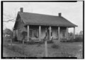
Gallery[]
Below are photographs taken in Mount Vernon as part of the Historic American Buildings Survey:

Cooper-Beasley House

L. B. Curry House

Indian Schoolhouse
Nelias Fall House


References[]
- ^ "2020 U.S. Gazetteer Files". United States Census Bureau. Retrieved October 29, 2021.
- ^ "Mobile Press-Register 200th Anniversary: Annexations triple city; Mobile adds cultural icons, gallows retired (1950-1959)". 26 June 2013.
- ^ "US Gazetteer files: 2010, 2000, and 1990". United States Census Bureau. 2011-02-12. Retrieved 2011-04-23.
- ^ "U.S. Decennial Census". Census.gov. Retrieved June 6, 2013.
- ^ "Annual Estimates of the Resident Population: April 1, 2010 to July 1, 2013". Retrieved June 3, 2014.
- ^ "U.S. Census website". United States Census Bureau. Retrieved 2008-01-31.
- ^ "U.S. Census website". United States Census Bureau. Retrieved 2015-08-04.
- ^ "Explore Census Data". data.census.gov. Retrieved 2021-12-14.
- ^ a b Idowu, Modupe (2016-05-25). "Officials decide future of two schools: Mae Eanes Belsaw-Mount Vernon". NBC 15. Retrieved 2018-11-27.
Mae Eanes will be merged with Williamson High School and Belsaw-Mount Vernon Elementary School will go to North Mobile K-8.
- ^ "Citronelle High School Attendance Zone." Mobile County Public School System. Retrieved on November 27, 2018.
- ^ "2010 CENSUS - CENSUS BLOCK MAP: Mount Vernon town, AL." U.S. Census Bureau. Retrieved on November 28, 2018.
- ^ "Schools." Town of Mount Vernon. Retrieved on July 29, 2016.
- ^ A copy of the school's attendance boundary, as the file "Belsaw Mt. Vernon.pdf", is available from the Mobile County Public School System Student Support Services Department. This file was previously available online (see "Elementary Attendance Zone Maps(A-I)" "Belsaw Mt Vernon" but the link is broken)
- ^ a b Devoe, Emily (2016-05-24). "Mobile County School Board Votes to Close Two Schools". WKRG. Retrieved 2018-11-27.
- ^ Johnson, Jason (2016-05-25). "School board closes Mae Eanes, Belshaw-Mt. Vernon schools". . Retrieved 2018-11-27.
- ^ District of Columbia Police: A Retrospect of the Police Organizations of the Cities of Washington and Georgetown and the District of Columbia, with Biographical Sketches ... and Historic Cases. Pub. for the Benefit of the Policemen's Fund. Gibson Bros., printers. 1894. p. 174.
Coordinates: 31°05′35″N 88°00′40″W / 31.09317°N 88.011209°W
Municipalities and communities of Mobile County, Alabama, United States | ||
|---|---|---|
| Cities |  | |
| Towns | ||
| CDPs | ||
| Unincorporated communities | ||
| Ghost town | ||
| Indian reservation | ||
| Footnotes | ‡This populated place also has portions in an adjacent county or counties | |
| ||
- Towns in Mobile County, Alabama
- Towns in Alabama