Muir of Ord
Muir of Ord
| |
|---|---|
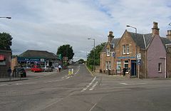 The centre of the village | |
 Muir of Ord Location within the Ross and Cromarty area | |
| Population | 2,690 (mid-2016 est.)[1] |
| OS grid reference | NH5250 |
| • Edinburgh | 118 mi (190 km) |
| • London | 450 mi (724 km) |
| Council area | |
| Lieutenancy area | |
| Country | Scotland |
| Sovereign state | United Kingdom |
| Post town | Muir of Ord |
| Postcode district | IV6 |
| Dialling code | 01463 |
| Police | Scotland |
| Fire | Scottish |
| Ambulance | Scottish |
| UK Parliament | |
| Scottish Parliament |
|

Muir of Ord (Scottish Gaelic: Am Blàr Dubh) is a village in the Highlands of Scotland. It is situated near the western boundary of the Black Isle, about 9 miles (14 km) west of the city of Inverness and 5+1⁄2 miles (9 km) south of Dingwall.[2] The village has a population of 2,690[1] and sits 35 metres (115 ft) above sea level.[2] The Scottish geologist, Sir Roderick Murchison was born in the village in 1792.
History[]
Named Tarradale until 1862,[3] historically access to the village was limited by the natural obstacles of the River Beauly and the River Conon. This changed in 1814 with the construction of the Conon Bridge. Cattle drivers used the new routes to transport livestock and markets were set up in 1820 close to where the village now lies.[3] In 1835 whisky distilling operations were legally granted in the village and by 1885 the Mill of Ord produced 80,000 imperial gallons (360,000 l) per year. The village grew extensively in the 19th century due to the establishment of the distillery and goods industries.[4]
Castle Hill Henge[]
Also known as the Muir of Ord Fort, it is a Neolithic or Bronze-Age henge and national monument of Scotland situated 300 yards (270 m) from Muir of Ord railway station.[5] Today it is situated on the green of the Muir of Ord golf course. The henge measures 85 by 65 feet (26 by 20 m) and is surrounded by an 18 ft (5.5 m) wide ditch which is 4 ft (1.2 m) deep.[6] There also are two standing stones about 3⁄4 mile (1.2 km) away from the henge.[5]
Amenities[]

Just outside of the centre of the village is the Glen Ord Distillery, one of the few remaining whisky distilleries on the Black Isle.[7] The ,[8] one of the largest agricultural shows in Scotland, is held every August in a showground near Muir of Ord. The showground is a popular exhibition site thanks to the surrounding flower fields.
Muir of Ord used to have a local football team in the 2000s, Muir of Ord Rovers F.C., that competed in the North Caledonian Football League.[4]
The Muir Hub[9] is the newest community building in Muir of Ord. Originally belonging to Tarradale primary school the building had been left unused for numerous years before being refurbished in January 2017. It is now a charity funded venue situated in the heart of the village. The building is multi-functional serving as a cafe, small cinema, conference space and social space. Many local groups meet here and rooms can be rented out for events, clubs, meetings, etc.
Transport[]
The major route of the A9 road passed through the village until 1982, when it was bypassed by the Kessock Bridge.[10]
The village is served by Muir of Ord railway station, which is on the Kyle of Lochalsh Line and the Far North Line between Dingwall and Inverness.[11]
References[]
- ^ Jump up to: a b "Mid-2016 Population Estimates for Settlements and Localities in Scotland". National Records of Scotland. 12 March 2018. Retrieved 30 December 2020.
- ^ Jump up to: a b OS Explorer map: 432: Black Isle (Map). Ordnance Survey.
- ^ Jump up to: a b "Muir of Ord". Undiscovered Scotland. Retrieved 2 September 2018.
- ^ Jump up to: a b "Muir of Ord Drovers Football Club". Ambaile, Highland history and culture. 2004.
- ^ Jump up to: a b "Our 13th Green - Castle Hill Henge A Scheduled National Monument" (PDF). muirofordgolfclub.co.uk. March 2018.
- ^ "Castle Hill, Muir Of Ord". Canmore.org. Retrieved 2 September 2018.
- ^ Glen Ord Distillery
- ^ Black Isle Show
- ^ [1]
- ^ Brocklehurst, Steven (6 March 2014). "Life and death on the A9". BBC News (Scotland - Highlands & Islands).
- ^ Brailsford, Martyn, ed. (December 2017) [1987]. Railway Track Diagrams 1: Scotland & Isle of Man (6th ed.). Frome: Trackmaps. map 18C. ISBN 978-0-9549866-9-8.
External links[]
| show Authority control |
|---|
- Populated places on the Black Isle