N-5 National Highway
 | |
|---|---|
| قومی شاہراہ 5 | |
 | |
| Route information | |
| Part of | |
| Length | 1,819 km (1,130 mi) |
| Existed | 1913–present |
| Major junctions | |
| South end | Karachi |
Lahore Ring Road Thokar Niaz Baig Interchange Lahore Ring Road Niazi Biag Interchange Islamabad Expressway T-Chowk Interchange Kashmir Highway Motorway Interchange M-1-N-5 Link Road Interchange Peshawar Ring Road Eastern Interchange Peshawar Ring Road Western Interchange | |
| North end | Torkham |
| Highway system | |
| Roads in Pakistan | |
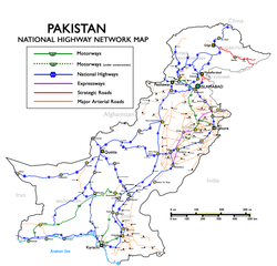
The N-5 or National Highway 5 (Urdu: قومی شاہراہ 5) is a 1819 km national highway in Pakistan,[1] which extends from Karachi in Sindh to Torkham in Khyber Pakhtunkhwa. The N-5 is the longest national highway in Pakistan and serves as an important north–south road artery, starting from Karachi and extending through Hyderabad, Moro and Sukkur in Sindh before crossing into Punjab province where it passes through Multan, Sahiwal, Lahore, Gujranwala, Gujrat, Jhelum and Rawalpindi. At Rawalpindi, it turns westwards and passes through Attock Khurd before crossing the Indus River into Khyber Pakhtunkhwa to continue through Nowshera and Peshawar before entering the Khyber Pass and reaching the border town of Torkham in the FATA. Its total length is divided into 1021 km in Punjab, 671 km in Sindh, and 165 km in Khyber Pakhtunkhwa. It is managed by the National Highway Authority.
History[]
Part of the highway was built on the ancient Grand Trunk Road (commonly known as G.T. Road) which came under jurisdiction of the new state after the independence of Pakistan in 1947. Thus developments of this road took place, and in the 1990s, the road was converted into an international standard highway.
Route[]
In Pakistan, the historical Grand Trunk Route extendeds from Wagha, Punjab to Peshawar, Khyber Pakhtunkhwa. In the early 1990s, the National Highway Authority merged several regional highways and converted them into a 4-lane 1,819-kilometre-long (1,130 mi) highway, known today as N-5 National Highway. The original highways were:
- Peshawar-Torkham Road
- Grand Trunk Road (Peshawar-Lahore)
- Lahore-Multan Road
- Multan-Bahawalpur Road
- KLP Road (Bahawal Pur-Rahim Yar Khan)
- Karachi-Rahim Yar Khan Road
Junctions and interchanges[]
This article contains a bulleted list or table of intersections which should be presented in a properly formatted junction table. (November 2021) |
Sindh[]
| Number | Location | Km marker no |
|---|---|---|
| 1 | Karachi | 00 |
| 2 | Thatta | 94 |
| 3 | Kotri | 145 |
| 4 | Hyderabad | 163 |
| 5 | Matiari | 190 |
| 6 | New Saeedabad | 229 |
| 7 | Sabu Rahu | 240 |
| 8 | Sakrand | 250 |
| 9 | Sukhio Manahejo | 264 |
| 10 | Kazi Ahmed | 275 |
| 11 | Daulatpur | 302 |
| 12 | Shahpur Jehanian | 310 |
| 13 | Moro | 320 |
| 14 | Naushahro Feroze | 345 |
| 15 | Bhiria | 356 |
| 16 | Kandiaro | 373 |
| 17 | Kotri Kabir | 391 |
| 18 | Ranipur | 413 |
| 19 | Kot Diji | 437 |
| 20 | Khairpur | 458 |
| 21 | Sukkur | 470 |
| 22 | Pano Akil | 515 |
| 23 | Ghotki | 543 |
| 24 | Sarhad | 554 |
| 25 | Mirpur Mathelo | 568 |
| 26 | Daharki | 582 |
| 27 | Ubauro | 596 |
Punjab[]
| Number | Location | Km marker no |
|---|---|---|
| 28 | Kot Sabzal | 612 |
| 29 | 620 | |
| 30 | Sadiqabad | 637 |
| 31 | Rahim Yar Khan | 655 |
| 32 | 677 | |
| 33 | 687 | |
| 34 | 693 | |
| 35 | Zahir Pir | 707 |
| 36 | 719 | |
| 37 | Khan Bela | 734 |
| 38 | 756 | |
| 39 | Ahmadpur East | 792 |
| 40 | Deran | 794 |
| 41 | 814 | |
| 42 | Khanqah Sharif | 829 |
| 43 | Bahawalpur | 844 |
| 44 | Lodhran | 860 |
| 45 | 872 | |
| 46 | 883 | |
| 47 | Basti Maluk | 896 |
| 48 | Lar | 915 |
| 49 | Multan | 937 |
| 50 | Qadirpur Ran | 957 |
| 51 | Khanewal | 980 |
| 52 | 1020 | |
| 53 | Mian Channu | 1026 |
| 54 | Harappa | 1082 |
| 55 | Sahiwal | 1102 |
| 56 | Qadirabad | 1114 |
| 57 | Okara | 1134 |
| 58 | Renala Khurd | 1151 |
| 59 | Akhtarabad | 1161 |
| 60 | Wan Radha Ram | 1168 |
| 61 | Pattoki | 1180 |
| 62 | Bhai Pheru | 1204 |
| 63 | 1220 | |
| 64 | Chung | 1239 |
| 65 | Lahore | 1271 |
| 66 | Ferozewala | 1260 |
| 67 | Kala Shah Kaku | 1272 |
| 68 | Muridke | 1287[2] |
| 69 | Kamoke | 1307 |
| 70 | Eimanabad Mord | 1316 |
| 71 | Gujranwala | 1328 |
| 72 | Ghakhar | 1347 |
| 73 | Wazirabad | 1362 |
| 74 | Gujrat | 1380 |
| 75 | Lala Musa | 1397 |
| 76 | Kharian | 1412 |
| 77 | Sarai Alamgir | 1426 |
| 78 | Jhelum | 1432 |
| 79 | Dina | 1448 |
| 80 | Sohawa | 1473 |
| 81 | Gujar Khan | 1491 |
| 82 | 1505 | |
| 83 | Rawat, (Islamabad Capital Territory) | 1522 |
| 84 | Islamabad, Islamabad Highway Junction, Defence Housing Authority, Bahria Town (Islamabad Capital Territory) | 1524 |
| 85 | Rawalpindi | 1540 |
| 86 | Islamabad, Road junction to Islamabad Main City, Tarnol, Link to New Gandhara Intn'l Airport, Sangjani, CDA New Sectors (Islamabad Capital Territory) | 1551 |
| 87 | John Nicholson's oblisk | 1565 |
| 88 | Taxila | 1569 |
| 89 | Wah Cantt | 1579 |
| 90 | Hasan Abdal | 1585 |
| 91 | Burhan | 1595 |
| 92 | 1601.012 | |
| 93 | Lawrencepur | 1602 |
| 94 | 1609 | |
| 95 | Kamra | 1611 |
| 96 | 1618 | |
| 97 | Haji Shah | 1619 |
| 98 | Attock Khurd | 1621 |
Khyber Pakhtunkhwa[]
| Number | Location | Km marker no |
|---|---|---|
| 99 | Jehangira | 1640 |
| 100 | Nowshera | 1657 |
| 101 | Pabbi | 1678 |
| 102 | Peshawar | 1700 |
FATA[]
| Number | Location | Km marker no |
|---|---|---|
| 103 | Jamrud | 1718 |
| 104 | Shagai Fort | 1725 |
| 105 | Torkham | 1756 |
References[]
- ^ Amin Ahmed (1 January 2021). "China to provide $100m grant for road project". Dawn (newspaper). Retrieved 9 October 2021.
- ^ "N5 National Highway". National Highway Authority website. Archived from the original on 12 July 2012. Retrieved 9 October 2021.
External links[]
| National Highways | ||
|---|---|---|
| Strategic Highways | ||
| National Highways |
| |||||
|---|---|---|---|---|---|---|
| Motorways | ||||||
| Expressways | ||||||
| Provincial Highways | ||||||
Electronic Toll & Traffic Management (ETTM)
There are Eleven (11) Electronic Toll & Traffic Management (ETTM) System Based Toll Plazas of National Highways.
| 1 | Iqbal Shaheed |
| 2 | Harro |
| 3 | Sangjani |
| 4 | Mandra |
| 5 | Tarakki |
| 6 | Jhelum |
| 7 | Chenab |
| 8 | Gujranwala |
| 9 | Okara |
| 10 | Harappa |
| 11 | Khanbela |
This article on a road in Pakistan is a stub. You can help Wikipedia by . |
- AH1
- Roads in Pakistan
- Roads in Punjab, Pakistan
- Roads in Khyber Pakhtunkhwa
- Roads in Sindh
- Asia road stubs
- Pakistan transport stubs