National Register of Historic Places listings in Franklin Lakes, New Jersey

Map of Bergen County, New Jersey, highlighting Franklin Lakes
| Atlantic - Bergen - Burlington - Camden - Cape May - Cumberland - Essex - Gloucester - Hudson - Hunterdon - Mercer - Middlesex - Monmouth - Morris - Ocean - Passaic - Salem - Somerset - Sussex - Union - Warren |
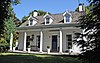
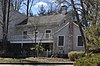
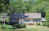
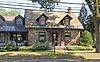
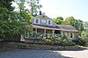
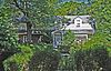
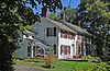
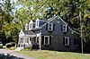
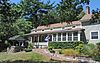
The table below includes 14 sites listed on the National Register of Historic Places in the Borough of Franklin Lakes, New Jersey in Bergen County. Latitude and longitude coordinates of the sites listed on this page may be displayed in a map or exported in several formats by clicking on one of the links in the box below the map to the right.[1]
National Register listings elsewhere in Bergen County may be found in separate articles.
- This National Park Service list is complete through NPS recent listings posted February 11, 2022.[2]
Current listings[]


References[]
- ^ The latitude and longitude information provided in this table was derived originally from the National Register Information System, which has been found to be fairly accurate for about 99% of listings. Some locations in this table may have been corrected to current GPS standards.
- ^ National Park Service, United States Department of the Interior, "National Register of Historic Places: Weekly List Actions", retrieved February 11, 2022.
- ^ Numbers represent an alphabetical ordering by significant words. Various colorings, defined here, differentiate National Historic Landmarks and historic districts from other NRHP buildings, structures, sites or objects.
- ^ "National Register Information System". National Register of Historic Places. National Park Service. July 9, 2010.
- ^ The eight-digit number below each date is the number assigned to each location in the National Register Information System database, which can be viewed by clicking the number.
| Topics |  | ||
|---|---|---|---|
| Lists by county | |||
| Lists by city |
| ||
| Other lists | |||
| |||
Municipalities and communities of Bergen County, New Jersey, United States | ||
|---|---|---|
| Cities |  | |
| Boroughs |
| |
| Townships | ||
| Villages | ||
| CDP |
| |
| Unincorporated communities |
| |
| ||
Categories:
- Franklin Lakes, New Jersey
- Lists of National Register of Historic Places in Bergen County, New Jersey