Emerson, New Jersey
Emerson, New Jersey | |
|---|---|
| Borough of Emerson | |
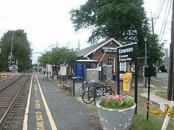 NJ Transit station in Emerson | |
| Nickname(s): "The Family Town" | |
 Map highlighting Emerson's location within Bergen County. Inset: Bergen County's location within New Jersey | |
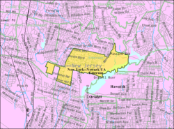 Census Bureau map of Emerson, New Jersey | |
| Coordinates: 40°58′30″N 74°01′24″W / 40.97499°N 74.023248°WCoordinates: 40°58′30″N 74°01′24″W / 40.97499°N 74.023248°W[1][2] | |
| Country | |
| State | |
| County | |
| Incorporated | April 8, 1903 (as Etna)[3] |
| Name changed | March 9, 1909 (to Emerson)[3] |
| Named for | Ralph Waldo Emerson |
| Government | |
| • Type | Borough |
| • Body | Borough Council |
| • Mayor | Danielle DiPaola (R, term ends December 31, 2022)[4] |
| • Administrator | Robert G. Hermansen[5] |
| • Municipal clerk | Jane S. Dietsche[6] |
| Area | |
| • Total | 2.42 sq mi (6.27 km2) |
| • Land | 2.23 sq mi (5.78 km2) |
| • Water | 0.19 sq mi (0.49 km2) 7.85% |
| Area rank | 379th of 565 in state 40th of 70 in county[1] |
| Elevation | 49 ft (15 m) |
| Population | |
| • Total | 7,401 |
| • Estimate (2019)[12] | 7,596 |
| • Rank | 308th of 566 in state 51st of 70 in county[13] |
| • Density | 3,358.9/sq mi (1,296.9/km2) |
| • Density rank | 194th of 566 in state 39th of 70 in county[13] |
| Time zone | UTC−05:00 (Eastern (EST)) |
| • Summer (DST) | UTC−04:00 (Eastern (EDT)) |
| ZIP Code | |
| Area code(s) | 201[16] |
| FIPS code | 3400321450[1][17][18] |
| GNIS feature ID | 0885208[1][19] |
| Website | www |

Emerson is a borough in Bergen County, New Jersey, United States, a suburb in the New York City metropolitan area. Emerson is the most southern town in an area of the county referred to as the Pascack Valley. As of the 2010 United States Census, the borough's population was 7,401,[9][10][11] reflecting an increase of 204 (+2.8%) from the 7,197 counted in the 2000 Census, which had in turn increased by 267 (+3.9%) from the 6,930 counted in the 1990 Census.[20]
What is now Emerson was originally formed on April 8, 1903, from portions of Washington Township as the Borough of Etna, the name of a railroad station in the community.[21] The name was changed to Emerson as of March 9, 1909.[3][22] The name came from author Ralph Waldo Emerson.[23][24] The borough calls itself "The Family Town".[25]
Geography[]
According to the United States Census Bureau, the borough had a total area of 2.42 square miles (6.27 km2), including 2.23 square miles (5.78 km2) of land and 0.19 square miles (0.49 km2) of water (7.85%).[1][2]
Unincorporated communities, localities and place names located partially or completely within the borough include Old Hook.[26]
The borough borders the Bergen County municipalities of Closter, Harrington Park, Haworth, Oradell, Paramus, River Vale, Washington Township and Westwood.[27][28][29]
Demographics[]
| Historical population | |||
|---|---|---|---|
| Census | Pop. | %± | |
| 1900 | 456 | — | |
| 1910 | 767 | 68.2% | |
| 1920 | 973 | 26.9% | |
| 1930 | 1,394 | 43.3% | |
| 1940 | 1,487 | 6.7% | |
| 1950 | 1,744 | 17.3% | |
| 1960 | 6,849 | 292.7% | |
| 1970 | 8,428 | 23.1% | |
| 1980 | 7,793 | −7.5% | |
| 1990 | 6,930 | −11.1% | |
| 2000 | 7,197 | 3.9% | |
| 2010 | 7,401 | 2.8% | |
| 2019 (est.) | 7,596 | [12][30][31] | 2.6% |
| Population sources: 1910-1920[32] 1910[33] 1910-1930[34] 1900-2010[35][36][37] 2000[38][39] 2010[9][10][11] | |||
Census 2010[]
The 2010 United States census counted 7,401 people, 2,480 households, and 1,967 families in the borough. The population density was 3,358.9 per square mile (1,296.9/km2). There were 2,552 housing units at an average density of 1,158.2 per square mile (447.2/km2). The racial makeup was 87.31% (6,462) White, 1.08% (80) Black or African American, 0.04% (3) Native American, 8.55% (633) Asian, 0.11% (8) Pacific Islander, 1.15% (85) from other races, and 1.76% (130) from two or more races. Hispanic or Latino of any race were 8.36% (619) of the population.[9]
Of the 2,480 households, 36.2% had children under the age of 18; 67.7% were married couples living together; 8.0% had a female householder with no husband present and 20.7% were non-families. Of all households, 18.1% were made up of individuals and 11.5% had someone living alone who was 65 years of age or older. The average household size was 2.89 and the average family size was 3.29.[9]
23.9% of the population were under the age of 18, 6.0% from 18 to 24, 21.3% from 25 to 44, 29.0% from 45 to 64, and 19.8% who were 65 years of age or older. The median age was 44.3 years. For every 100 females, the population had 92.1 males. For every 100 females ages 18 and older there were 86.0 males.[9]
The Census Bureau's 2006-2010 American Community Survey showed that (in 2010 inflation-adjusted dollars) median household income was $99,292 (with a margin of error of +/- $12,946) and the median family income was $108,300 (+/- $12,689). Males had a median income of $71,868 (+/- $16,071) versus $69,271 (+/- $15,233) for females. The per capita income for the borough was $39,501 (+/- $4,093). About 0.7% of families and 1.1% of the population were below the poverty line, including none of those under age 18 and 4.5% of those age 65 or over.[40]
Same-sex couples headed 17 households in 2010, an increase from the 14 counted in 2000.[41]
Census 2000[]
As of the 2000 United States Census[17] there were 7,197 people, 2,373 households, and 1,964 families residing in the borough. The population density was 3,216.3 people per square mile (1,240.5/km2). There were 2,398 housing units at an average density of 1,071.7 per square mile (413.3/km2). The racial makeup of the borough was 89.62% White, 0.85% African American, 0.06% Native American, 7.89% Asian, 0.88% from other races, and 0.71% from two or more races. Hispanic or Latino of any race were 4.61% of the population.[38][39]
As of the 2000 Census, 2.2% of Emerson's residents identified themselves as being of Armenian-American ancestry. This was the 20th highest percentage of Armenian American people in any place in the United States with 1,000 or more residents identifying their ancestry.[42]
There were 2,373 households, out of which 36.1% had children under the age of 18 living with them, 72.5% were married couples living together, 7.3% had a female householder with no partner present, and 17.2% were non-families. 14.5% of all households were made up of individuals, and 8.3% had someone living alone who was 65 years of age or older. The average household size was 2.91 and the average family size was 3.23.[38][39]
In the borough the population was spread out, with 23.2% under the age of 18, 5.5% from 18 to 24, 27.5% from 25 to 44, 25.1% from 45 to 64, and 18.8% who were 65 years of age or older. The median age was 41 years. For every 100 females, there were 91.2 males. For every 100 females age 18 and over, there were 87.2 males.[38][39]
The median income for a household in the borough was $75,556, and the median income for a family was $83,521. Males had a median income of $52,450 versus $36,818 for females. The per capita income for the borough was $31,506. About 1.3% of families and 2.4% of the population were below the poverty line, including 1.3% of those under age 18 and 4.0% of those age 65 or over.[38][39]
Economy[]
Pascack Valley Shopping Center is a shopping center located on Kinderkamack Road. It had a movie theater and bowling alley.[43]
Parks and recreation[]
Parks in the borough include:[44]
- Ackerman Park, located on Ackerman Avenue. It has a playground, basketball courts, a bocci court, and picnic area.[45]
- Centennial Park, located on Main Street, has a gazebo and walking path and a residents-only community garden (opened in 2017) managed by the Environmental Commission. It was named Centennial Park in 2003 in honor Emerson's 100th Anniversary.[46]
- Hillman Park, located on Thomas Street, was created on land donated by borough resident Richard Hillman. It has baseball fields such as, Ken Benkovic Jr. Memorial Field, which was a majors field that is fenced in and a lighted field, and Babes Field which is also a lighted field behind the firehouse but is also located on Thomas Street. There is also a soccer field, and a playground.[47]
- Rosengart Park, sometimes referred as "Sunset Park", is a park located on Sunset Place. It has a playground.[48]
- Veterans' Park, a memorial park located on High Street, with monuments honoring veterans from Emerson.[49]
- Washington Park, a park located on Washington Avenue. It has a playground and a picnic area.[50]
- Emerson Woods covers approximately 19 acres (7.7 ha) of woodland along Main Street east of the high school, and is located in the buffer area of the Oradell Reservoir. The property was slated for townhouse development, but local opposition resulted in the parcel being purchased by the borough in 2001, with the aid of grants from the county and state. It remains in its natural state, with the addition of trails to make the property accessible to visitors.[51]
Government[]
Local government[]
Emerson is governed under the Borough form of New Jersey municipal government, which is used in 218 municipalities (of the 565) statewide, making it the most common form of government in New Jersey.[52] The governing body is comprised of the Mayor and the Borough Council, with all positions elected at-large on a partisan basis as part of the November general election. A Mayor is elected directly by the voters to a four-year term of office. The Borough Council is comprised of six members elected to serve three-year terms on a staggered basis, with two seats coming up for election each year in a three-year cycle.[7][53] The Borough form of government used in Emerson is a "weak mayor / strong council" government in which council members act as the legislative body with the mayor presiding at meetings and voting only in the event of a tie. The mayor can veto ordinances subject to an override by a two-thirds majority vote of the council. The mayor makes committee and liaison assignments for council members, and most appointments are made by the mayor with the advice and consent of the council.[54][55]
As of 2020, the Mayor of Emerson Borough is Republican Danielle DiPaola, whose term of office ends December 31, 2022. Members of the Emerson Borough Council are Council President Kenneth Hoffman (R, 2021), Nicole Argenzia (R, 2022), James Bayley (D, 2020), Patricia L. Dinallo (D, 2020; appointed to serve an unexpired term), Brian Gordon (R, 2021) and Jill McGuire (R, 2022).[56][57][58][59][60][61]
In January 2020, the Borough Council selected Patricia L. Dinallo to fill the seat expiring in December 2020 that had been held by Christopher Knoller until he resigned from office late in 2019; with Dinallo taking office and Nicole Argenzia and Jill McGuire sworn in to full terms, Emerson's governing body had a female majority for the first time since the borough was established.[62]
In January 2019, the Borough Council selected Jill McGuire from three candidates nominated by the Republican municipal committee to fill the seat expiring in December 2019 that was vacated by Danielle DiPaola when she took office as the borough's first female mayor.[63]
Day-to-day operation of the Borough is handled by Richard J. Sheola, who serves as Interim Borough Administrator.[5] The Borough Clerk is Jane S. Dietsche[6] and the CFO is Catherine Henderson.[64]
Federal, state and county representation[]
Emerson is located in the 5th Congressional District[65] and is part of New Jersey's 39th state legislative district.[10][66][67]
For the 117th United States Congress, New Jersey's Fifth Congressional District is represented by Josh Gottheimer (D, Wyckoff).[68][69] New Jersey is represented in the United States Senate by Democrats Cory Booker (Newark, term ends 2027)[70] and Bob Menendez (Harrison, term ends 2025).[71][72]
For the 2020–2021 session (Senate, General Assembly), the 39th Legislative District of the New Jersey Legislature is represented in the State Senate by Holly Schepisi (R, Rivervale) and in the General Assembly by Robert Auth (R, Old Tappan) and DeAnne DeFuccio (R, Upper Saddle River).[73][74]
Bergen County is governed by a directly elected County Executive, with legislative functions performed by the seven-member Bergen County Board of County Commissioners (formerly the Bergen County Board of Chosen Freeholders). The freeholders are elected at-large in partisan elections on a staggered basis, with two or three seats coming up for election each year; a Chairman, Vice Chairman and Chairman Pro Tempore are selected from among its seven members at a reorganization meeting held every January. Other Bergen County Constitutional Offices include County Clerk, Sheriff, and Surrogate. These offices all have 3 year terms, and are elected on a partisan basis.
As of July 2021, the County Executive is Democrat James J. Tedesco III of Paramus, whose term of office ends December 31, 2022.[75] The current members of the Bergen County Board of Commissioners are Freeholder Chairman Steven A. Tanelli (D, North Arlington, 2021),[76] Freeholder Vice-Chairwoman Tracy Silna Zur (D, Franklin Lakes, 2021),[77] Freeholder Chairman Pro-Tempore Dr. Joan Voss (D, Fort Lee, 2023)[78] Mary J. Amoroso (D, Mahwah, term as freeholder ends 2022),[79] Germaine M. Ortiz (D, Emerson, term as freeholder ends 2022),[80] Ramon M. Hache, Sr. (D, Ridgewood, 2023),[81] and Thomas J. Sullivan Jr., (D, Montvale, term as freeholder ends 2022),[82]
Bergen County's constitutional officials are County Clerk John S. Hogan (D, Northvale, 2021),[83] Sheriff Anthony Cureton (D, Emerson, 2021)[84] and Surrogate Michael R. Dressler (D, Cresskill, 2021).[85]
Politics[]
As of March 23, 2011, there were a total of 4,690 registered voters in Emerson, of which 905 (19.3% vs. 31.7% countywide) were registered as Democrats, 2,025 (43.2% vs. 21.1%) were registered as Republicans and 1,759 (37.5% vs. 47.1%) were registered as Unaffiliated. There was one voter registered to another party.[86] Among the borough's 2010 Census population, 63.4% (vs. 57.1% in Bergen County) were registered to vote, including 83.3% of those ages 18 and over (vs. 73.7% countywide).[86][87]
In the 2016 presidential election Republican Donald Trump received 2,188 votes (55.2%), ahead of Democrat Hillary Clinton with 1,629 votes (40.9%) and other candidates with 150 votes (3.8%).[88] In the 2012 presidential election, Republican Mitt Romney received 2,019 votes (55.7% vs. 43.5% countywide), ahead of Democrat Barack Obama with 1,532 votes (42.3% vs. 54.8%) and other candidates with 31 votes (0.9% vs. 0.9%), among the 3,623 ballots cast by the borough's 4,899 registered voters, for a turnout of 74.0% (vs. 70.4% in Bergen County).[89][90] In the 2008 presidential election, Republican John McCain received 2,206 votes (56.7% vs. 44.5% countywide), ahead of Democrat Barack Obama with 1,636 votes (42.0% vs. 53.9%) and other candidates with 28 votes (0.7% vs. 0.8%), among the 3,893 ballots cast by the borough's 4,922 registered voters, for a turnout of 79.1% (vs. 76.8% in Bergen County).[91][92] In the 2004 presidential election, Republican George W. Bush received 2,228 votes (58.2% vs. 47.2% countywide), ahead of Democrat John Kerry with 1,553 votes (40.6% vs. 51.7%) and other candidates with 23 votes (0.6% vs. 0.7%), among the 3,829 ballots cast by the borough's 4,913 registered voters, for a turnout of 77.9% (vs. 76.9% in the whole county).[93]
In the 2013 gubernatorial election, Republican Chris Christie received 69.4% of the vote (1,716 cast), ahead of Democrat Barbara Buono with 30.0% (742 votes), and other candidates with 0.6% (16 votes), among the 2,547 ballots cast by the borough's 4,753 registered voters (73 ballots were spoiled), for a turnout of 53.6%.[94][95] In the 2009 gubernatorial election, Republican Chris Christie received 1,547 votes (55.7% vs. 45.8% countywide), ahead of Democrat Jon Corzine with 1,042 votes (37.5% vs. 48.0%), Independent Chris Daggett with 140 votes (5.0% vs. 4.7%) and other candidates with 11 votes (0.4% vs. 0.5%), among the 2,779 ballots cast by the borough's 4,824 registered voters, yielding a 57.6% turnout (vs. 50.0% in the county).[96]
Education[]
The Emerson School District serves public school students in pre-kindergarten through twelfth grade. As of the 2018–19 school year, the district, comprised of three schools, had an enrollment of 1,139 students and 98.8 classroom teachers (on an FTE basis), for a student–teacher ratio of 11.5:1.[97] Schools in the district (with 2018–19 enrollment data from the National Center for Education Statistics[98]) are Memorial Elementary School[99] with 302 students in PreK-2, Patrick M. Villano Elementary School[100] with 316 students in grades 3-6 and Emerson Jr./Sr. High School[101] with 496 students in grades 7-12.[102][103]
Public school students from the borough, and all of Bergen County, are eligible to attend the secondary education programs offered by the Bergen County Technical Schools, which include the Bergen County Academies in Hackensack, and the Bergen Tech campus in Teterboro or Paramus. The district offers programs on a shared-time or full-time basis, with admission based on a selective application process and tuition covered by the student's home school district.[104][105]
Assumption Academy is a parochial early childhood school that operates under the auspices of the Roman Catholic Archdiocese of Newark.[106][107] Assumption Academy closed its elementary school program for grades 1–8 in June 2012 due to declining enrollment, which it had been struggling to keep up for several years prior.[108]
Transportation[]

Roads and highways[]
As of May 2010, the borough had a total of 30.87 miles (49.68 km) of roadways, of which 28.54 miles (45.93 km) were maintained by the municipality and 2.33 miles (3.75 km) by Bergen County.[109]
The most significant roads serving Emerson are County Route 502 (Old Hook Road) and County Route 503 (Kinderkamack Road).
Public transportation[]
The Emerson station, located at the intersection of Linwood Avenue and Kinderkamack Road,[110] provides service on NJ Transit's Pascack Valley Line. This line runs north–south to Hoboken Terminal with connections via the Secaucus Junction transfer station to NJ Transit one-stop service to New York Penn Station and to ten other NJ Transit rail lines. Connections are available at the Hoboken Terminal to other NJ Transit rail lines, the PATH train at the Hoboken PATH station, New York Waterways ferry service to the World Financial Center and other destinations and Hudson-Bergen Light Rail service.[111]
NJ Transit provides bus service on the 165 route to and from the Port Authority Bus Terminal in Midtown Manhattan.[112][113]
Rockland Coaches routes 11A/11AT provide service to the Port Authority Bus Terminaland to Rockland County, New York.[114] Saddle River Tours / Ameribus provides service to the George Washington Bridge Bus Station on route 11C.[115]
Bomb threat[]
On September 19, 2007, there was a threat made to the Emerson School System. A letter addressed to Emerson Mayor Lou Lamatina was received around 10:30 a.m. in a small envelope, along with what appeared to be a computer-printed address pasted onto the front, authorities said. The note inside appeared to also be computer-generated, and was pasted on a blank piece of paper; it read, "All three schools will be blown out on Thursday, Sept. 20th at 11:30 a.m., with two other schools in nearby towns." The note was later sent to the Bergen County Sheriff's Office for forensic examination.[116]
All three Emerson Schools were immediately evacuated by a fire drill around 11:00, and neither students nor teachers were allowed to collect any of their belongings, including backpacks, cell phones, and purses. Seniors were allowed to retrieve their cars later that day, but nobody else was allowed near the school.
Members of the Bergen County bomb squad were sent to Emerson on Wednesday morning; however, a search of the district's schools revealed nothing dangerous or extraordinary. The bomb squad also searched Oradell and Washington Township schools, and searched Emerson's Assumption Academy on Thursday morning.
Thirteen districts closed their schools for September 20, 2007, including Emerson, Westwood, Washington Township, Oradell, River Edge, Closter, River Vale, Demarest, Haworth, Harrington Park, Northvale, Norwood, and Old Tappan. Some selected Catholic grammar and high schools were closed. The bomb threat affected 12–14,000 students, including 1,200 from Emerson alone. The schools were closed for two days until they were deemed safe.[117]
Points of interest[]
- Cedar Park Cemetery
- Emerson Public Library was formed in 1957 and moved to its current facility in 1974.[118]
- Soldier Hill Golf Club - The Bergen County Freeholders spent $8.5 million to acquire the semi-private course, which opened in 1963 and covers portions of both Emerson and Oradell near the Oradell Reservoir on 140 acres (57 ha) of land that had been owned by United Water until it sold off the property in 2008.[119]
Notable people[]
People who were born in, residents of, or otherwise closely associated with Emerson include:
- Aron Abrams (1960-2010), screenwriter.[120]
- Nicki Gross (born 1989), assistant coach for the Iowa Energy of the NBA Development League.[121]
- Kevin Higgins (born 1955), assistant football coach and WR coach at Wake Forest University.[122]
- Sonny Igoe (1923-2012), jazz drummer.[123]
- Andy Papathanassiou, pit crew coordinator of NASCAR's Hendrick Motorsports.[124]
Sources[]
- Municipal Incorporations of the State of New Jersey (according to Counties) prepared by the Division of Local Government, Department of the Treasury (New Jersey); December 1, 1958.
- Clayton, W. Woodford; and Nelson, Nelson. History of Bergen and Passaic Counties, New Jersey, with Biographical Sketches of Many of its Pioneers and Prominent Men. Philadelphia: Everts and Peck, 1882.
- Harvey, Cornelius Burnham (ed.), Genealogical History of Hudson and Bergen Counties, New Jersey. New York: New Jersey Genealogical Publishing Co., 1900.
- Van Valen, James M. History of Bergen County, New Jersey. New York: New Jersey Publishing and Engraving Co., 1900.
- Westervelt, Frances A. (Frances Augusta), 1858–1942, History of Bergen County, New Jersey, 1630-1923, Lewis Historical Publishing Company, 1923.
References[]
- ^ Jump up to: a b c d e f 2019 Census Gazetteer Files: New Jersey Places, United States Census Bureau. Accessed July 1, 2020.
- ^ Jump up to: a b U.S. Gazetteer Files for 2000, 2010 and 2012-2016, United States Census Bureau. Accessed September 4, 2017.
- ^ Jump up to: a b c Snyder, John P. The Story of New Jersey's Civil Boundaries: 1606-1968, Bureau of Geology and Topography; Trenton, New Jersey; 1969. p. 75. Accessed May 31, 2012.
- ^ 2020 New Jersey Mayors Directory, New Jersey Department of Community Affairs. Accessed February 1, 2020.
- ^ Jump up to: a b Administration, Borough of Emerson. Accessed March 24, 2020.
- ^ Jump up to: a b Municipal Clerk, Borough of Emerson. Accessed March 24, 2020.
- ^ Jump up to: a b 2012 New Jersey Legislative District Data Book, Rutgers University Edward J. Bloustein School of Planning and Public Policy, March 2013, p. 165.
- ^ U.S. Geological Survey Geographic Names Information System: Borough of Emerson, Geographic Names Information System. Accessed March 5, 2013.
- ^ Jump up to: a b c d e f DP-1 - Profile of General Population and Housing Characteristics: 2010 for Emerson borough, Bergen County, New Jersey, United States Census Bureau. Accessed March 5, 2013.
- ^ Jump up to: a b c d Municipalities Sorted by 2011-2020 Legislative District, New Jersey Department of State. Accessed February 1, 2020.
- ^ Jump up to: a b c Profile of General Demographic Characteristics: 2010 for Emerson borough Archived 2012-04-02 at the Wayback Machine, New Jersey Department of Labor and Workforce Development. Accessed March 5, 2013.
- ^ Jump up to: a b QuickFacts for Emerson borough, New Jersey; Bergen County, New Jersey; New Jersey from Population estimates, July 1, 2019, (V2019), United States Census Bureau. Accessed May 21, 2020.
- ^ Jump up to: a b GCT-PH1 Population, Housing Units, Area, and Density: 2010 - State -- County Subdivision from the 2010 Census Summary File 1 for New Jersey, United States Census Bureau. Accessed March 5, 2013.
- ^ Look Up a ZIP Code for Emerson, NJ, United States Postal Service. Accessed September 14, 2011.
- ^ ZIP Codes, State of New Jersey. Accessed August 15, 2013.
- ^ Area Code Lookup - NPA NXX for Westampton, NJ, Area-Codes.com. Accessed December 5, 2013.
- ^ Jump up to: a b U.S. Census website, United States Census Bureau. Accessed September 4, 2014.
- ^ Geographic Codes Lookup for New Jersey, Missouri Census Data Center. Accessed September 1, 2019.
- ^ US Board on Geographic Names, United States Geological Survey. Accessed September 4, 2014.
- ^ Table 7. Population for the Counties and Municipalities in New Jersey: 1990, 2000 and 2010, New Jersey Department of Labor and Workforce Development, February 2011. Accessed March 5, 2013.
- ^ Emerson: A Brief History, Borough of Emerson. Accessed March 24, 2020.
- ^ History of Bergen County, Vol. 1, p. 354-355 shows March 16, 1909 for creation of Emerson.
- ^ Hutchinson, Viola L. The Origin of New Jersey Place Names, New Jersey Public Library Commission, May 1945. Accessed August 30, 2015.
- ^ Lurie, Maxine N.; and Mappen, Marc. "Emerson", p. 252. Encyclopedia of New Jersey, Rutgers University Press, 2004. ISBN 9780813533254. Accessed December 5, 2013.
- ^ About Emerson, Borough of Emerson. Accessed February 28, 2021.
- ^ Locality Search, State of New Jersey. Accessed May 21, 2015.
- ^ Areas touching Emerson, MapIt. Accessed March 24, 2020.
- ^ Bergen County Map of Municipalities, Bergen County, New Jersey. Accessed March 24, 2020.
- ^ New Jersey Municipal Boundaries, New Jersey Department of Transportation. Accessed November 15, 2019.
- ^ Annual Estimates of the Resident Population for Minor Civil Divisions in New Jersey: April 1, 2010 to July 1, 2019, United States Census Bureau. Accessed May 21, 2020.
- ^ Census Estimates for New Jersey April 1, 2010 to July 1, 2019, United States Census Bureau. Accessed May 21, 2020.
- ^ Compendium of censuses 1726-1905: together with the tabulated returns of 1905, New Jersey Department of State, 1906. Accessed August 15, 2013.
- ^ Thirteenth Census of the United States, 1910: Population by Counties and Minor Civil Divisions, 1910, 1900, 1890, United States Census Bureau, p. 335. Accessed May 31, 2012.
- ^ Fifteenth Census of the United States : 1930 - Population Volume I, United States Census Bureau, p. 714. Accessed May 31, 2012.
- ^ New Jersey Resident Population by Municipality: 1930 - 1990, Workforce New Jersey Public Information Network. Accessed May 31, 2012.
- ^ Bergen County Data Book 2003 Archived 2013-07-24 at the Wayback Machine, Bergen County, New Jersey. Accessed August 15, 2013. Data for 1900 was extrapolated by County statisticians.
- ^ Historical Population Trends in Bergen County (1900-2010), Bergen County Department of Planning & Economic Development, 2011. Accessed September 26, 2019. Data for 1900, prior to the borough's formation, was extrapolated by analysts from Bergen County.
- ^ Jump up to: a b c d e Census 2000 Profiles of Demographic / Social / Economic / Housing Characteristics for Emerson borough, New Jersey Archived 2014-08-08 at the Wayback Machine, United States Census Bureau. Accessed March 5, 2013.
- ^ Jump up to: a b c d e DP-1: Profile of General Demographic Characteristics: 2000 - Census 2000 Summary File 1 (SF 1) 100-Percent Data for Emerson borough, Bergen County, New Jersey, United States Census Bureau. Accessed March 5, 2013.
- ^ DP03: Selected Economic Characteristics from the 2006-2010 American Community Survey 5-Year Estimates for Emerson borough, Bergen County, New Jersey, United States Census Bureau. Accessed May 31, 2012.
- ^ Lipman, Harvy; and Sheingold, Dave. "North Jersey sees 30% growth in same-sex couples", The Record, August 14, 2011, backed up by the Internet Archive as of February 3, 2013. Accessed July 24, 2013.
- ^ Armenian Communities, EPodunk. Accessed June 28, 2006.
- ^ Pascack Valley Shopping Center, Wikimapia. Accessed March 16, 2015.
- ^ Emerson's Parks, Borough of Emerson. Accessed March 24, 2020.
- ^ Ackerman Park, Borough of Emerson. Accessed March 24, 2020.
- ^ Centennial Park, Borough of Emerson. Accessed March 24, 2020.
- ^ Hillman Park, Borough of Emerson. Accessed March 24, 2020.
- ^ Rosengart Park, Borough of Emerson. Accessed March 24, 2020.
- ^ Veterans' Park, Borough of Emerson. Accessed March 24, 2020.
- ^ Washington Park, Borough of Emerson. Accessed March 24, 2020.
- ^ Emerson Woods, Borough of Emerson. Accessed March 24, 2020. "Emerson Woods is a 19-acre preserve that is part of the watershed buffer surrounding the Oradell Reservoir. Emerson Woods, located on Main Street, was purchased by the Borough of Emerson in December 2001 with grants and loans from the Bergen County Open Space Trust Fund and NJ DEP Green Acres."
- ^ Inventory of Municipal Forms of Government in New Jersey, Rutgers University Center for Government Studies, July 1, 2011. Accessed November 18, 2019.
- ^ Your Governing Body, Borough of Emerson. Accessed March 24, 2020.
- ^ Cerra, Michael F. "Forms of Government: Everything You've Always Wanted to Know, But Were Afraid to Ask" Archived 2014-09-24 at the Wayback Machine, New Jersey State League of Municipalities. Accessed November 30, 2014.
- ^ "Forms of Municipal Government in New Jersey", p. 6. Rutgers University Center for Government Studies. Accessed June 3, 2015.
- ^ Mayor & Council, Borough of Emerson. Accessed March 24, 2020. "The Borough of Emerson was chartered in 1903 as a Borough Council form of government in which the Mayor is elected to a four-year tem and six council members are elected at large to serve staggered three-year terms."
- ^ 2019 Municipal Data Sheet, Borough of Emerson. Accessed September 29, 2019.
- ^ 2018 County and Municipal Directory, Bergen County, New Jersey. Accessed September 26, 2019.
- ^ Bergen County November 5, 2019 General Election Statement of Vote, Bergen County, New Jersey Clerk, updated December 10, 2019. Accessed January 1, 2020.
- ^ Bergen County November 6, 2018 General Election Statement of Vote, Bergen County, New Jersey Clerk, updated February 11, 2019. Accessed September 26, 2019.
- ^ Bergen County Statement of Vote General Election 2017, Bergen County Clerk. Accessed May 15, 2018.
- ^ Noda, Stephanie. "Emerson swears in a majority-female governing body", The Record, January 4, 2020. Accessed March 24, 2020. "For the first time in the borough history, the governing body is majority female.... Mayor Danielle DiPaola swore in Democrat Patricia Dinallo and Republicans Nicole Argenzia and Jill McGuire to the Borough Council during the annual reorganization meeting Thursday, while noting that the move came on the 100th anniversary of the year women won the right to vote.Councilman Chris Knoller, whose term was set to end in 2020, resigned from the six-member council at the end of 2019, leading to the appointment of Patricia Dinallo, who ran as a Democratic in the 2019 election."
- ^ Snyder, John. "Jill McGuire Joins Emerson Borough Council", Pascack Press, January 21, 2019. Accessed September 29, 2019. "Saying she was moved that her new post as a borough councilmember earned her bipartisan and unanimous approval, Historic Preservation Committee Chair Jill McGuire slid into her seat at the dais, ready to get to work.... Three Republicans were nominated to fill the one-year unexpired term left by Mayor Danielle DiPaola: McGuire, Don Pierro, and Michael Timmerman."
- ^ CFO/Treasurer/Tax Collector/QPA, Borough of Emerson. Accessed March 24, 2020.
- ^ Plan Components Report, New Jersey Redistricting Commission, December 23, 2011. Accessed February 1, 2020.
- ^ 2019 New Jersey Citizen's Guide to Government, New Jersey League of Women Voters. Accessed October 30, 2019.
- ^ Districts by Number for 2011-2020, New Jersey Legislature. Accessed January 6, 2013.
- ^ Directory of Representatives: New Jersey, United States House of Representatives. Accessed January 3, 2019.
- ^ Biography, Congressman Josh Gottheimer. Accessed January 3, 2019. "Josh now lives in Wyckoff, New Jersey with Marla, his wife who was a federal prosecutor, and their two young children, Ellie and Ben."
- ^ [1], United States Senate. Accessed April 30, 2021. "He now owns a home and lives in Newark's Central Ward community."
- ^ Biography of Bob Menendez, United States Senate, January 26, 2015. "Menendez, who started his political career in Union City, moved in September from Paramus to one of Harrison's new apartment buildings near the town's PATH station.."
- ^ [2]. United States Senate. Accessed April 30, 2021. "Booker, Cory A. - (D - NJ) Class II; Menendez, Robert - (D - NJ) Class I"
- ^ Legislative Roster 2020-2021 Session, New Jersey Legislature. Accessed December 15, 2020.
- ^ District 39 Legislators, New Jersey Legislature. Accessed December 15, 2020.
- ^ County Executive, Bergen County, New Jersey. Accessed July 28, 2021.
- ^ [3], Bergen County, New Jersey. Accessed July 28, 2021.
- ^ [4], Bergen County, New Jersey. Accessed July 28, 2021.
- ^ [5], Bergen County, New Jersey. Accessed July 28, 2021.
- ^ [6], Bergen County, New Jersey. Accessed July 28, 2021.
- ^ [7], Bergen County, New Jersey. Accessed July 28, 2021.
- ^ [8], Bergen County, New Jersey. Accessed July 28, 2021.
- ^ [9], Bergen County, New Jersey. Accessed July 28, 2021.
- ^ About the Clerk, Bergen County Clerk. Accessed July 28, 2021.
- ^ [10], Bergen County Sheriff's Office. Accessed July 28, 2021.
- ^ [11], Bergen County Surrogate's Court. Accessed July 28, 2021.
- ^ Jump up to: a b Voter Registration Summary - Bergen, New Jersey Department of State Division of Elections, March 23, 2011. Accessed December 5, 2013.
- ^ GCT-P7: Selected Age Groups: 2010 - State -- County Subdivision; 2010 Census Summary File 1 for New Jersey, United States Census Bureau. Accessed December 5, 2013.
- ^ [12], Bergen County Clerk, November 8, 2016. Accessed May 24, 2020.
- ^ Presidential November 6, 2012 General Election Results - Bergen County Archived December 7, 2013, at the Wayback Machine, New Jersey Department of State Division of Elections, March 15, 2013. Accessed December 5, 2013.
- ^ Number of Registered Voters and Ballots Cast November 6, 2012 General Election Results - Bergen County Archived December 7, 2013, at the Wayback Machine, New Jersey Department of State Division of Elections, March 15, 2013. Accessed December 5, 2013.
- ^ 2008 Presidential General Election Results: Bergen County, New Jersey Department of State Division of Elections, December 23, 2008. Accessed December 5, 2013.
- ^ "2008 General Election Results for Emerson Archived 2012-03-29 at the Wayback Machine, The Record. Accessed September 14, 2011.
- ^ 2004 Presidential Election: Bergen County, New Jersey Department of State Division of Elections, December 13, 2004. Accessed December 5, 2013.
- ^ "Governor - Bergen County" (PDF). New Jersey Department of Elections. January 29, 2014. Retrieved December 24, 2014.
- ^ "Number of Registered Voters and Ballots Cast - November 5, 2013 - General Election Results - Bergen County" (PDF). New Jersey Department of Elections. January 29, 2014. Retrieved December 24, 2014.
- ^ 2009 Governor: Bergen County Archived 2013-12-07 at the Wayback Machine, New Jersey Department of State Division of Elections, December 31, 2009. Accessed December 5, 2013.
- ^ District information for Emerson Public School District, National Center for Education Statistics. Accessed April 1, 2020.
- ^ School Data for the Emerson School District, National Center for Education Statistics. Accessed April 1, 2020.
- ^ Memorial Elementary School, Emerson School District. Accessed May 27, 2020.
- ^ Patrick M. Villano Elementary School, Emerson School District. Accessed May 27, 2020.
- ^ Emerson Junior-Senior High School, Emerson School District. Accessed May 27, 2020.
- ^ Our Schools, Emerson Public Schools. Accessed May 27, 2020.
- ^ New Jersey School Directory for the Emerson School District, New Jersey Department of Education. Accessed December 29, 2016.
- ^ About Us, Bergen County Technical Schools. Accessed December 5, 2013.
- ^ Admissions, Bergen County Technical Schools. Accessed December 23, 2016.
- ^ About Us, Assumption Academy. Accessed September 14, 2017.
- ^ Bergen County Elementary Schools, Roman Catholic Archdiocese of Newark. Accessed July 20, 2016.
- ^ Harris, Chris. "Parents confused, frustrated over closing of Assumption Academy in Emerson", The Record, February 28, 2012, backed up by the Internet Archive as of December 23, 2015. Accessed September 14, 2017. "Parents picking up children from Assumption Academy on Tuesday expressed both frustration and confusion over the elementary school's impending closure. On Monday, the Archdiocese of Newark designated eight schools for closure in Bergen, Essex, Union, and Hudson counties in June, including Assumption Academy on Jefferson Avenue."
- ^ Bergen County Mileage by Municipality and Jurisdiction, New Jersey Department of Transportation, May 2010. Accessed December 1, 2013.
- ^ Emerson station, NJ Transit. Accessed December 5, 2013.
- ^ Pascack Valley Line, NJ Transit. Accessed December 5, 2013.
- ^ Bergen County Bus / Rail Connections, NJ Transit, backed up by the Internet Archive as of May 22, 2009. Accessed September 14, 2011.
- ^ Bergen County System Map, NJ Transit. Accessed September 14, 2016.
- ^ Services operating from Emerson, NJ to New York, NY, Rockland Coaches. Accessed September 14, 2017.
- ^ Route 11C Weekday Schedule, Saddle River Tours / Ameribus. Accessed December 11, 2014.
- ^ Kelley, Tina. "A Bomb Threat Closes Schools in Bergen County", The New York Times, September 20, 2007. Accessed September 22, 2007.
- ^ The writer has not been caught. "Bomb threat closes schools in northern N.J.", USA Today, September 20, 2007. Accessed September 14, 2017.
- ^ Library History, Emerson Public Library. Accessed June 19, 2016. "The Emerson Public Library was founded by a small group of dedicated residents in 1957 as a private library, which charged one dollar per year in dues.... However, throughout this period, the library was still operating out of its cramped quarters in the Field House, but in 1974, a new, purpose-built facility was completed. This is the building that houses the library today."
- ^ Cowen, Richard. "Semi-private Emerson Golf Club to become public by spring", The Record, October 18, 2017. Accessed October 30, 2017. "The freeholders unanimously approved an ordinance to allow the Bergen County Improvement Authority to float $8.5 million in notes to finance the purchase of two lots, one which contains the 7,000-yard, par-71 golf course, and the other, a five-acre parcel that includes the clubhouse and parking lot.... The 135-acre, Par 71 course runs through Oradell and Emerson and is on land that was once owned by United Water. There is a deed restriction on the property that requires that the land remain a golf course forever."
- ^ Staff. "Writer Aron Abrams dies at 50: Wrote for 'Everybody Hates Chris,' 'King of the Hill'", Variety (magazine), December 29, 2010, backed up by the Internet Archive as of April 12, 2016. Accessed September 14, 2017. "Raised in Emerson, N.J., he attended Oberlin and Connecticut College."
- ^ Locicero, Anthony. "Emerson Native, Iowa Energy Official Lone Female Coach In NBA League", Pascack Valley Daily Voice, March 4, 2016. Accessed April 25, 2016. "Emerson's Nicki Gross is making history as the National Basketball Association Development League's lone female coach at the moment."
- ^ Kevin Higgins, Detroit Lions, backed up by the Internet Archive as of February 21, 2005. Accessed September 14, 2017. "He was also the head basketball coach and assistant football coach at Emerson (N.J.) High School from 1977-78. A native of Emerson, N.J., Higgins attended Emerson High School where he was captain of the football, basketball and baseball teams during his senior year."
- ^ Levin, Jay. "Sonny Igoe, drummer for Big Band greats, dies at 88", The Record, April 3, 2012, backed up by the Internet Archive as of December 23, 2015. Accessed September 14, 2017. "Sonny Igoe of Emerson, a Big Band drummer and a prolific teacher, died Wednesday."
- ^ Bernstein, Viv. "On Pit Row, It's First and Tire Change", The New York Times, August 15, 2006. Accessed October 17, 2007. "Hendrick Motorsports was the first to hire a pit crew coordinator when Andy Papathanassiou of Emerson, N.J., a former Stanford football player, joined the team in 1993."
External links[]
| Wikimedia Commons has media related to Emerson, New Jersey. |
- Emerson Borough website
- Emerson Public Schools
- Emerson School District's 2015–16 School Report Card from the New Jersey Department of Education
- School Data for the Emerson School District, National Center for Education Statistics
| show Municipalities and communities of Bergen County, New Jersey, United States |
|---|

| show Authority control |
|---|
- Emerson, New Jersey
- 1903 establishments in New Jersey
- Borough form of New Jersey government
- Boroughs in Bergen County, New Jersey
- Pascack Valley
- Populated places established in 1903