1
December 10, 2010 (#10001001 ) Lincoln's State Fairgrounds 40°49′53″N 96°41′34″W / 40.831389°N 96.692778°W / 40.831389; -96.692778 (Agricultural Hall ) Lincoln
2
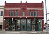
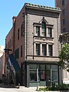
Antelope Grocery
March 17, 1988 (#88000213 ) 2406 J St. 40°48′30″N 96°41′10″W / 40.80821°N 96.6861°W / 40.80821; -96.6861 (Antelope Grocery ) Lincoln
3
Barr Terrace
October 1, 1979 (#79003688 ) 627-643 S. 11th, and 1044 H St. 40°48′26″N 96°42′21″W / 40.80729°N 96.70595°W / 40.80729; -96.70595 (Barr Terrace ) Lincoln Part of the Nineteenth Century Terrace Houses Thematic Resource (TR)
4
March 12, 2012 (#12000104 ) 726 L St. 40°48′39″N 96°42′39″W / 40.810935°N 96.710717°W / 40.810935; -96.710717 (Beatrice Creamery Company Lincoln Plant ) Lincoln
5
James A. Beattie House
December 4, 1990 (#90001773 ) 6706 Colby St. 40°50′00″N 96°37′43″W / 40.83339°N 96.62875°W / 40.83339; -96.62875 (James A. Beattie House ) Lincoln
6
Jasper Newton Bell House
June 21, 1984 (#84002483 ) 2212 Sheldon St. 40°49′38″N 96°41′22″W / 40.82736°N 96.68953°W / 40.82736; -96.68953 (Jasper Newton Bell House ) Lincoln
7
December 10, 2008 (#08001180 ) Roughly bounded by South St., Calvert and High Sts., S. 22nd and S. 24th Sts., Rock Island Trail, and Sheridan Boulevard 40°47′04″N 96°41′05″W / 40.784444°N 96.684722°W / 40.784444; -96.684722 (Boulevards Historic District ) Lincoln
8
Guy A. Brown House
March 5, 1998 (#98000195 ) 219-221 S. 27th St. 40°48′42″N 96°40′58″W / 40.81174°N 96.68264°W / 40.81174; -96.68264 (Guy A. Brown House ) Lincoln
9
August 29, 2012 (#12000565 ) Bounded by A, D, S. 37th to S. 40th Sts. 40°48′03″N 96°39′56″W / 40.800767°N 96.665656°W / 40.800767; -96.665656 (Brownbilt Residential Historic District ) Lincoln
10
Burckhardt House
June 25, 1999 (#99000746 ) 1236 Washington St. 40°47′54″N 96°42′11″W / 40.79833°N 96.70317°W / 40.79833; -96.70317 (Burckhardt House ) Lincoln Part of the African American Historic and Architectural Resources in Lincoln, Nebraska MPS
11
Edgar A. Burnett House
July 12, 2006 (#06000609 ) 3256 Holdrege St. 40°49′42″N 96°40′28″W / 40.828333°N 96.67444°W / 40.828333; -96.67444 (Edgar A. Burnett House ) Lincoln
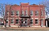
12
Burr Block
May 18, 1979 (#79001448 ) 1206 O St. 40°48′50″N 96°42′14″W / 40.81389°N 96.70381°W / 40.81389; -96.70381 (Burr Block ) Lincoln
13
James D. Calhoun House
April 26, 2002 (#02000411 ) 1130 Plum St. 40°47′34″N 96°42′17″W / 40.79286°N 96.70481°W / 40.79286; -96.70481 (James D. Calhoun House ) Lincoln
14
William H. Charlton House
January 25, 1997 (#96001614 ) 17705 S. 12th Street[5] 40°38′13″N 96°42′22″W / 40.63702°N 96.70617°W / 40.63702; -96.70617 (William H. Charlton House ) Roca
15
June 20, 1997 (#97000609 ) Near the junction of 7th and Q Sts. 40°48′57″N 96°42′42″W / 40.81589°N 96.71164°W / 40.81589; -96.71164 (Chicago, Burlington & Quincy Steam Locomotive No. 710 ) Lincoln
16
Christian Record Building
December 1, 1986 (#86003384 ) 3705 S. 48th St. 40°46′33″N 96°39′16″W / 40.77581°N 96.65444°W / 40.77581; -96.65444 (Christian Record Building ) Lincoln
17
City Hall
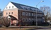
October 15, 1969 (#69000132 ) 920 O St. 40°48′50″N 96°42′28″W / 40.81392°N 96.70777°W / 40.81392; -96.70777 (City Hall ) Lincoln
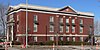
18
College View Public Library
June 28, 1984 (#84002486 ) 3800 S. 48th St. 40°46′23″N 96°39′13″W / 40.77317°N 96.65369°W / 40.77317; -96.65369 (College View Public Library ) Lincoln
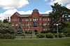
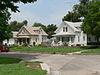
19
July 31, 2017 (#100001394 ) Generally bounded by L to A Sts., 56th & Cotner Blvd. to Sunrise & Mulder Drs. 40°48′19″N 96°38′24″W / 40.805301°N 96.640023°W / 40.805301; -96.640023 (Eastridge Historic District ) Lincoln 478 contributing buildings.
20
Eddy-Taylor House
July 21, 1983 (#83001098 ) 435 N. 25th 40°49′03″N 96°41′08″W / 40.81762°N 96.68544°W / 40.81762; -96.68544 (Eddy-Taylor House ) Lincoln
21
Fairview
October 15, 1966 (#66000947 ) 4900 Sumner St. 40°47′45″N 96°39′06″W / 40.79581°N 96.65163°W / 40.79581; -96.65163 (Fairview ) Lincoln
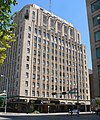
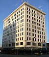
22
Federal Trust Building
April 25, 2002 (#02000409 ) 134 S. 13th St. 40°48′46″N 96°42′08″W / 40.81269°N 96.70236°W / 40.81269; -96.70236 (Federal Trust Building ) Lincoln
23
William H. Ferguson House
November 29, 1972 (#72000755 ) 700 S. 16th St. 40°48′24″N 96°41′52″W / 40.80661°N 96.69786°W / 40.80661; -96.69786 (William H. Ferguson House ) Lincoln
24
First National Bank Building
March 5, 1998 (#98000190 ) 1001 O St. 40°48′48″N 96°42′24″W / 40.81335°N 96.70679°W / 40.81335; -96.70679 (First National Bank Building ) Lincoln
25
July 24, 1986 (#86001936 ) 1551 N. Cotner Boulevard 40°49′44″N 96°37′50″W / 40.82883°N 96.63069°W / 40.82883; -96.63069 (First State Bank of Bethany ) Lincoln
26
Frank E. and Emma A. Gillen House
March 5, 1998 (#98000188 ) 2245 A St. 40°47′55″N 96°41′17″W / 40.79869°N 96.68819°W / 40.79869; -96.68819 (Frank E. and Emma A. Gillen House ) Lincoln
27
Gold and Company Store Building
October 19, 1982 (#82000609 ) 1033 O St. 40°48′48″N 96°42′21″W / 40.81322°N 96.70597°W / 40.81322; -96.70597 (Gold and Company Store Building ) Lincoln
28
April 15, 2004 (#04000303 ) N. 9th to N. 10th St., O to P Sts. 40°48′51″N 96°42′28″W / 40.81414°N 96.70773°W / 40.81414; -96.70773 (Government Square ) Lincoln
29
June 25, 1997 (#97000611 ) Roughly, R St. from 14th to 17th Sts. and 16th St. from R toVine Sts. 40°49′06″N 96°41′55″W / 40.818333°N 96.698611°W / 40.818333; -96.698611 (Greek Row Historic District ) Lincoln
30
Harris House
September 2, 1982 (#82003194 ) 1630 K St. 40°48′34″N 96°41′51″W / 40.80942°N 96.69739°W / 40.80942; -96.69739 (Harris House ) Lincoln
31
August 23, 1985 (#85001795 ) 1215 N. 9th 40°49′34″N 96°42′31″W / 40.82616°N 96.70861°W / 40.82616; -96.70861 (Hayward School ) Lincoln
32
Helmer-Winnett-White Flats
October 1, 1979 (#79003690 ) 1022-1028 K St. 40°48′34″N 96°42′22″W / 40.80939°N 96.70619°W / 40.80939; -96.70619 (Helmer-Winnett-White Flats ) Lincoln Part of the Nineteenth Century Terrace Houses TR
33
Herter Farmstead
July 24, 2000 (#00000835 ) 4949 S. 148th[6] 40°45′51″N 96°31′16″W / 40.764167°N 96.521111°W / 40.764167; -96.521111 (Herter Farmstead ) Walton
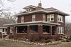
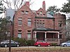
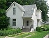
34
W.F. Hitchcock House
December 5, 2002 (#02001482 ) 2733 Sheridan Boulevard 40°47′11″N 96°40′54″W / 40.7865°N 96.6816°W / 40.7865; -96.6816 (W.F. Hitchcock House ) Lincoln Colonial Revival-styled house built in 1922
35
Hotel Capital
December 5, 1983 (#83003994 ) 139 N. 11th St. 40°48′52″N 96°42′21″W / 40.81446°N 96.70587°W / 40.81446; -96.70587 (Hotel Capital ) Lincoln
36
Aeneas Yates-Charles Hurlbut House
September 17, 1999 (#99001167 ) 720 S. 16th St. 40°48′22″N 96°41′52″W / 40.80611°N 96.69783°W / 40.80611; -96.69783 (Aeneas Yates-Charles Hurlbut House ) Lincoln Now occupied by Alpha Delta Pi sorority[7]
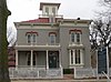
37
Thomas P. Kennard House
April 16, 1969 (#69000134 ) 1627 H St. 40°48′24″N 96°41′51″W / 40.80663°N 96.69741°W / 40.80663; -96.69741 (Thomas P. Kennard House ) Lincoln
38
July 1, 1994 (#94000651 ) 3232 Holdrege St. 40°49′42″N 96°40′30″W / 40.82828°N 96.67494°W / 40.82828; -96.67494 (Theodore A. Kiesselbach House ) Lincoln
39
August 28, 2012 (#12000566 ) 124 S. 9th St. 40°48′47″N 96°42′29″W / 40.812997°N 96.708024°W / 40.812997; -96.708024 (Rose Kirkwood Brothel ) Lincoln
40
December 2, 2014 (#14001014 ) 1401 S. 15th St. 40°47′56″N 96°42′00″W / 40.798960°N 96.699979°W / 40.798960; -96.699979 (Amel H. Koop House ) Lincoln
41
Lancaster Block
April 12, 1989 (#89000245 ) 6201-6205 Havelock Ave. 40°51′25″N 96°38′08″W / 40.85686°N 96.63556°W / 40.85686; -96.63556 (Lancaster Block ) Lincoln
42
Lewis-Syford House
February 18, 1971 (#71000486 ) 700 N. 16th St.[8] 40°49′13″N 96°41′52″W / 40.82014°N 96.69775°W / 40.82014; -96.69775 (Lewis-Syford House ) Lincoln
43
June 17, 1993 (#93000535 ) 4601 NW. 48th St. 40°51′38″N 96°47′15″W / 40.86049°N 96.78761°W / 40.86049; -96.78761 (Lincoln Army Air Field Regimental Chapel ) Lincoln
44
Lincoln Haymarket Historic District
July 8, 2014 (#14000288 ) Generally 7th to 9th & N to R Sts. 40°48′53″N 96°42′36″W / 40.8148°N 96.7100°W / 40.8148; -96.7100 (Lincoln Haymarket Historic District ) Lincoln (Develop this topic within Haymarket District (Lincoln, Nebraska) )
45
Lincoln Liberty Life Insurance Building
January 19, 1988 (#87002299 ) 113 N. 11th St. 40°48′50″N 96°42′21″W / 40.81386°N 96.70586°W / 40.81386; -96.70586 (Lincoln Liberty Life Insurance Building ) Lincoln
46
September 10, 2012 (#12000785 ) 600 S. 70th St. 40°48′32″N 96°37′21″W / 40.808888°N 96.622526°W / 40.808888; -96.622526 (Lincoln Veterans Administration Hospital Historic District ) Lincoln Part of the United States Second Generation Veterans Hospitals MPS
47
Lincoln YWCA Building
June 21, 1984 (#84002490 ) 1432 N St. 40°48′46″N 96°42′01″W / 40.81267°N 96.70025°W / 40.81267; -96.70025 (Lincoln YWCA Building ) Lincoln
48
Lyman Terrace
October 1, 1979 (#79003689 ) 1111-1119 H St. 40°48′24″N 96°42′18″W / 40.80671°N 96.70501°W / 40.80671; -96.70501 (Lyman Terrace ) Lincoln Part of the Nineteenth Century Terrace Houses TR
49
Masonic Temple
August 5, 2005 (#05000792 ) 1635 L St. 40°48′36″N 96°41′50″W / 40.80993°N 96.69727°W / 40.80993; -96.69727 (Masonic Temple ) Lincoln
50
June 25, 1999 (#99000748 ) 1723 N. 29th St. 40°49′49″N 96°40′48″W / 40.830339°N 96.679927°W / 40.830339; -96.679927 (McWilliams House ) Lincoln Part of the African American Historic and Architectural Resources in Lincoln, Nebraska MPS
51
June 5, 1980 (#80002453 ) Roughly bounded by A, G, 17th, and 22nd Sts. 40°48′08″N 96°41′34″W / 40.802222°N 96.692778°W / 40.802222; -96.692778 (Mount Emerald and Capitol Additions Historic Residential District ) Lincoln
52
July 24, 1986 (#86001938 ) 2901 A St. 40°47′55″N 96°40′41″W / 40.7986°N 96.6781°W / 40.7986; -96.6781 (Municipal Lighting and Waterworks Plant ) Lincoln
53
William L. and Sydney V. Murphy House
November 4, 1994 (#94001280 ) 2525 N St. 40°48′44″N 96°41′04″W / 40.81213°N 96.68455°W / 40.81213; -96.68455 (William L. and Sydney V. Murphy House ) Lincoln
54
July 11, 2002 (#02000771 ) 11700 SW. 100th St. 40°41′30″N 96°50′54″W / 40.69167°N 96.84833°W / 40.69167; -96.84833 (Nebraska City to Fort Kearny Cutoff Ruts at Spring Creek Prairie ) Denton
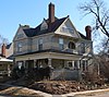
55
Nebraska Governor's Mansion
March 12, 2008 (#08000173 ) 1425 H St. 40°48′23″N 96°42′02″W / 40.80644°N 96.70047°W / 40.80644; -96.70047 (Nebraska Governor's Mansion ) Lincoln
56
Nebraska State Capitol
October 16, 1970 (#70000372 ) 1445 K St. 40°48′29″N 96°41′57″W / 40.808056°N 96.699167°W / 40.808056; -96.699167 (Nebraska State Capitol ) Lincoln
57
Nebraska State Historical Society Building
August 21, 2003 (#03000797 ) 1500 R St. 40°49′02″N 96°41′59″W / 40.81722°N 96.69965°W / 40.81722; -96.69965 (Nebraska State Historical Society Building ) Lincoln
58
Nebraska Telephone Company Building
November 16, 1978 (#78001703 ) 128-130 S. 13th St. 40°48′47″N 96°42′09″W / 40.81298°N 96.70239°W / 40.81298; -96.70239 (Nebraska Telephone Company Building ) Lincoln
59
Nine-Mile Prairie
July 30, 1986 (#86002089 ) Northwest of Huskerville 40°52′01″N 96°48′54″W / 40.866944°N 96.815°W / 40.866944; -96.815 (Nine-Mile Prairie ) Lincoln
60
Old Main, Nebraska Wesleyan University
May 21, 1975 (#75001097 ) 50th and St. Paul Sts. 40°50′20″N 96°38′58″W / 40.838889°N 96.649444°W / 40.838889; -96.649444 (Old Main, Nebraska Wesleyan University ) Lincoln
61
Old University Library
August 6, 1975 (#75001098 ) 11th and R Sts. 40°49′02″N 96°42′22″W / 40.81731°N 96.70611°W / 40.81731; -96.70611 (Old University Library ) Lincoln
62
Palisade and Regent Apartments
March 5, 1998 (#98000191 ) 1035 S. 17th St. and 1626 D St. 40°48′10″N 96°41′50″W / 40.80276°N 96.69725°W / 40.80276; -96.69725 (Palisade and Regent Apartments ) Lincoln
63
Park Hill
September 3, 2010 (#10000628 ) 1913 S. 41st St. 40°47′35″N 96°39′46″W / 40.79292°N 96.66267°W / 40.79292; -96.66267 (Park Hill ) Lincoln
64
September 4, 2013 (#13000675 ) Bounded by A, South, 56th & 70th Sts. 40°47′44″N 96°38′04″W / 40.795683°N 96.634369°W / 40.795683; -96.634369 (Park Manor Residential Historic District ) Lincoln
65
Peter Peterson Farmstead
February 11, 1980 (#80002456 ) Address Restricted Waverly
66
Phi Delta Theta Fraternity House
May 28, 1986 (#86001183 ) 1545 R St. 40°49′00″N 96°41′55″W / 40.81662°N 96.69848°W / 40.81662; -96.69848 (Phi Delta Theta Fraternity House ) Lincoln
67
November 25, 2005 (#05001329 ) 5305 Huntington Ave. 40°50′13″N 96°38′48″W / 40.83708°N 96.64678°W / 40.83708; -96.64678 (Phi Kappa Tau Fraternity House ) Lincoln
68
R.O. Phillips House
November 29, 1979 (#79001449 ) 1845 D St 40°48′08″N 96°41′40″W / 40.80215°N 96.69442°W / 40.80215; -96.69442 (R.O. Phillips House ) Lincoln
69
June 17, 1993 (#93000538 ) Junction of W. Van Dorn and Coddington Sts. 40°46′39″N 96°45′57″W / 40.7775°N 96.765833°W / 40.7775; -96.765833 (Pioneers Park ) Lincoln
70
President and Ambassador Apartments
December 10, 1993 (#93001401 ) 1330 and 1340 Lincoln Mall 40°48′30″N 96°42′06″W / 40.80833°N 96.70161°W / 40.80833; -96.70161 (President and Ambassador Apartments ) Lincoln
71
Quinn Chapel African Methodist Episcopal Church and Parsonage
June 25, 1999 (#99000749 ) 1225 S. 9th St. 40°48′04″N 96°42′32″W / 40.80114°N 96.70889°W / 40.80114; -96.70889 (Quinn Chapel African Methodist Episcopal Church and Parsonage ) Lincoln Part of the African American Historic and Architectural Resources in Lincoln, Nebraska MPS
72
Retzlaff Farmstead
May 31, 1979 (#79001450 ) Address Restricted Lincoln
73
Upload image March 13, 2020 (#100005055 ) 925 Robbers Cave Rd. 40°46′49″N 96°42′27″W / 40.7802°N 96.7074°W / 40.7802; -96.7074 (Robbers' Cave ) Lincoln
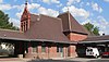
74
Rock Island Depot
September 3, 1971 (#71000487 ) 1944 O St. 40°48′51″N 96°41′34″W / 40.81426°N 96.69285°W / 40.81426; -96.69285 (Rock Island Depot ) Lincoln
75
Nimrod Ross House
June 25, 1999 (#99000747 ) 445 S. 30th St. 40°48′28″N 96°40′37″W / 40.807778°N 96.676944°W / 40.807778; -96.676944 (Nimrod Ross House ) Lincoln Part of the African American Historic and Architectural Resources in Lincoln, Nebraska MPS
76
Royer-Williams House
June 14, 1982 (#82003195 ) 407 N. 26th St. 40°49′02″N 96°41′02″W / 40.81714°N 96.68401°W / 40.81714; -96.68401 (Royer-Williams House ) Lincoln
77
Ryons-Alexander House
July 8, 1982 (#82003196 ) 1835 Ryons St. 40°47′26″N 96°41′41″W / 40.79061°N 96.69467°W / 40.79061; -96.69467 (Ryons-Alexander House ) Lincoln
78
St. Charles Apartments
September 12, 1985 (#85002138 ) 4717 Baldwin Ave. 40°50′17″N 96°39′17″W / 40.83806°N 96.65472°W / 40.83806; -96.65472 (St. Charles Apartments ) Lincoln
79
Upload image January 21, 1974 (#74002290 ) 9 miles (14 km) south of Lincoln[9] Roca Village along Salt Creek named for the landowner. Excavated by E.E. Blackman in 1901;[9] [10]
80
Scottish Rite Temple
December 1, 1986 (#86003359 ) 332 Centennial Mall, S. 40°48′38″N 96°41′58″W / 40.81061°N 96.69931°W / 40.81061; -96.69931 (Scottish Rite Temple ) Lincoln
81
Sheldon Memorial Art Gallery
September 3, 2013 (#13000676 ) 12th & R Sts., University of Nebraska–Lincoln 40°49′03″N 96°42′16″W / 40.8175°N 96.704444°W / 40.8175; -96.704444 (Sheldon Memorial Art Gallery ) Lincoln
82
Sky Park Manor
August 8, 2016 (#16000515 ) 1301 Lincoln Mall 40°48′29″N 96°42′08″W / 40.808084°N 96.702304°W / 40.808084; -96.702304 (Sky Park Manor ) Lincoln
83
South Bottoms Historic District
July 17, 1986 (#86001717 ) Roughly bounded by M and J and H and G Sts., 2nd and 9th Sts., and W. B Sts., and Salt Creek 40°48′16″N 96°43′02″W / 40.804444°N 96.717222°W / 40.804444; -96.717222 (South Bottoms Historic District ) Lincoln
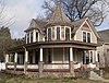
84
Frank M. Spalding House
March 25, 1999 (#99000386 ) 2221 Sheridan Boulevard 40°47′25″N 96°41′07″W / 40.79028°N 96.68536°W / 40.79028; -96.68536 (Frank M. Spalding House ) Lincoln
85
R.O. Stake House
April 27, 2005 (#05000357 ) 145 S. 28th St. 40°48′45″N 96°40′53″W / 40.81245°N 96.68127°W / 40.81245; -96.68127 (R.O. Stake House ) Lincoln
86
State Arsenal
September 17, 1981 (#81000372 ) 17th and Court Sts. 40°49′45″N 96°41′49″W / 40.82922°N 96.69696°W / 40.82922; -96.69696 (State Arsenal ) Lincoln
87
November 9, 2020 (#100005770 ) 1600-1608 O St. 40°48′49″N 96°41′52″W / 40.8137°N 96.6978°W / 40.8137; -96.6978 (Strode Building ) Lincoln
88
Stuart Building
December 23, 2003 (#03001341 ) 13th and P Sts. 40°48′52″N 96°42′08″W / 40.81442°N 96.70231°W / 40.81442; -96.70231 (Stuart Building ) Lincoln
89
Temple of Congregation B'nai Jeshurun
June 25, 1982 (#82003197 ) 2061 S. 20th Street[11] 40°47′31″N 96°41′32″W / 40.79192°N 96.69231°W / 40.79192; -96.69231 (Temple of Congregation B'nai Jeshurun ) Lincoln
90
Terminal Building
December 29, 1986 (#86003527 ) 947 O St. 40°48′48″N 96°42′26″W / 40.81335°N 96.70732°W / 40.81335; -96.70732 (Terminal Building ) Lincoln
91
John M. Thayer House
December 5, 2002 (#02001479 ) 1901 Prospect St. 40°47′41″N 96°41′38″W / 40.79472°N 96.69378°W / 40.79472; -96.69378 (John M. Thayer House ) Lincoln
92
Tifereth Israel Synagogue
May 9, 1985 (#85000958 ) 344 S. 18th St. 40°48′38″N 96°41′42″W / 40.81044°N 96.695°W / 40.81044; -96.695 (Tifereth Israel Synagogue ) Lincoln Now Tifereth Place Apts.[12]
93
William H. Tyler House
April 6, 1978 (#78001704 ) 808 D St. 40°48′10″N 96°42′35″W / 40.80281°N 96.709722°W / 40.80281; -96.709722 (William H. Tyler House ) Lincoln
94
February 7, 2003 (#03000069 ) Roughly Walker Ave., 51st-54th Sts., Leighton Ave., and 49th-53rd Sts. 40°50′09″N 96°39′06″W / 40.835833°N 96.651667°W / 40.835833; -96.651667 (University Place Historic Residential District ) Lincoln
95
Veith Building
September 18, 1980 (#80002454 ) 816 P St. 40°48′54″N 96°42′34″W / 40.81492°N 96.7094°W / 40.81492; -96.7094 (Veith Building ) Lincoln
96
Albert Watkins House
April 3, 1989 (#89000244 ) 920 D St. 40°48′10″N 96°42′28″W / 40.8028°N 96.7079°W / 40.8028; -96.7079 (Albert Watkins House ) Lincoln
97
November 12, 2015 (#15000794 ) 2742 N. 48th St. 40°50′25″N 96°39′12″W / 40.840167°N 96.653442°W / 40.840167; -96.653442 (Wesleyan Hospital and Nurses Training School ) Lincoln
98
Whitehall
October 29, 1982 (#82000610 ) 5903 Walker 40°50′10″N 96°38′24″W / 40.83622°N 96.63992°W / 40.83622; -96.63992 (Whitehall ) Lincoln
99
Woods Brothers Building
September 18, 1980 (#80002455 ) 132 S. 13th St. 40°48′46″N 96°42′09″W / 40.81291°N 96.70237°W / 40.81291; -96.70237 (Woods Brothers Building ) Lincoln
100
Frank and Nelle Cochrane Woods House
June 30, 1995 (#95000793 ) 2501 Sheridan Boulevard 40°47′14″N 96°41′04″W / 40.78736°N 96.68444°W / 40.78736; -96.68444 (Frank and Nelle Cochrane Woods House ) Lincoln
101
March 29, 2011 (#11000147 ) Bounded by High and Calvert Sts., South 17th to South 20th Sts. 40°46′45″N 96°41′41″W / 40.779167°N 96.694722°W / 40.779167; -96.694722 (Woodsshire Residential Historic District ) Lincoln
102
Wyuka Cemetery
July 19, 1982 (#82003198 ) 3600 O St. 40°49′01″N 96°39′54″W / 40.816944°N 96.665°W / 40.816944; -96.665 (Wyuka Cemetery ) Lincoln
103
John H. and Christina Yost House
April 26, 2002 (#02000410 ) 1900 S. 25th St. 40°47′36″N 96°41′08″W / 40.79328°N 96.6856°W / 40.79328; -96.6856 (John H. and Christina Yost House ) Lincoln
104
Arthur C. Ziemer House
November 23, 1977 (#77000832 ) 2030 Euclid Ave. 40°47′40″N 96°41′28″W / 40.79431°N 96.691111°W / 40.79431; -96.691111 (Arthur C. Ziemer House ) Lincoln