National Register of Historic Places listings in Las Animas County, Colorado
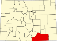
Location of Las Animas County in Colorado
This is a list of the National Register of Historic Places listings in Las Animas County, Colorado.
This is intended to be a complete list of the properties and districts on the National Register of Historic Places in Las Animas County, Colorado, United States. The locations of National Register properties and districts for which the latitude and longitude coordinates are included below, may be seen in a map.[1]
There are 37 properties and districts listed on the National Register in the county. Another 3 properties were once listed but have been removed.
- This National Park Service list is complete through NPS recent listings posted February 11, 2022.[2]
| Adams - Alamosa - Arapahoe - Archuleta - Baca - Bent - Boulder - Broomfield - Chaffee - Cheyenne - Clear Creek - Conejos - Costilla - Crowley - Custer - Delta - Denver - Dolores - Douglas - Eagle - El Paso - Elbert - Fremont - Garfield - Gilpin - Grand - Gunnison - Hinsdale - Huerfano - Jackson - Jefferson - Kiowa - Kit Carson - La Plata - Lake - Larimer - Las Animas - Lincoln - Logan - Mesa - Mineral - Moffat - Montezuma - Montrose - Morgan - Otero - Ouray - Park - Phillips - Pitkin - Prowers - Pueblo - Rio Blanco - Rio Grande - Routt - Saguache - San Juan - San Miguel - Sedgwick - Summit - Teller - Washington - Weld - Yuma |
Current listings[]


Former listings[]
| [3] | Name on the Register | Image | Date listed | Date removed | Location | City or town | Description |
|---|---|---|---|---|---|---|---|
| 1 | 1985 (#85001403) | September 16, 2002 | County Road over Leitensdorfer Arroyo and Apishapa River | Aguilar and Hoehne | |||
| 2 |  |
February 4, 1985 (#85000217) | July 22, 1994 | Commercial Street 37°10′24″N 104°30′49″W / 37.173333°N 104.513611°W | Trinidad | Replaced in 1990 | |
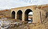
| 3 |  |
February 4, 1985 (#85000215) | September 16, 2002 | County Road 36 | El Moro | The bridge was disassembled and moved to Pueblo in 1994 or 1995. It is now a pedestrian bridge called Fay's Crossing. It goes over Santa Fe Avenue and carries the Runyon Commuter Trail. The bridge remains on the Colorado State Register of Historic Properties.[8] |
See also[]
| Wikimedia Commons has media related to National Register of Historic Places in Las Animas County, Colorado. |
- List of National Historic Landmarks in Colorado
- National Register of Historic Places listings in Colorado
References[]
- ^ The latitude and longitude information provided in this table was derived originally from the National Register Information System, which has been found to be fairly accurate for about 99% of listings. Some locations in this table may have been corrected to current GPS standards.
- ^ National Park Service, United States Department of the Interior, "National Register of Historic Places: Weekly List Actions", retrieved February 11, 2022.
- ^ a b Numbers represent an alphabetical ordering by significant words. Various colorings, defined here, differentiate National Historic Landmarks and historic districts from other NRHP buildings, structures, sites or objects.
- ^ "National Register Information System". National Register of Historic Places. National Park Service. July 9, 2010.
- ^ The eight-digit number below each date is the number assigned to each location in the National Register Information System database, which can be viewed by clicking the number.
- ^ Location derived from its GNIS feature record; the NRIS lists the site as "Address Restricted".
- ^ Location derived from its placement on USGS topographical maps; the NRIS lists the site as "Address Restricted".
- ^ "Elson Bridge (Original Location)". History Colorado. Retrieved 2021-04-30.
| Topics | |
|---|---|
| Lists by state |
|
| Lists by insular areas | |
| Lists by associated state | |
| Other areas | |
| Related | |
| |
Municipalities and communities of Las Animas County, Colorado, United States | ||
|---|---|---|
| City |  | |
| Towns | ||
| CDPs | ||
| Unincorporated communities | ||
| Ghost towns | ||
| ||
Categories:
- Lists of National Register of Historic Places in Colorado by county
- Las Animas County, Colorado
- National Register of Historic Places in Las Animas County, Colorado