Starkville, Colorado
Town of Starkville | |
|---|---|
Town | |
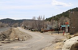 East Railroad Avenue (shown) serves as Starkville's main street. | |
 Location of Starkville in Las Animas County, Colorado. | |
| Coordinates: 37°7′1″N 104°31′24″W / 37.11694°N 104.52333°WCoordinates: 37°7′1″N 104°31′24″W / 37.11694°N 104.52333°W | |
| Country | |
| State | |
| County[1] | Las Animas County |
| Incorporated | March 2, 1954[2] |
| Government | |
| • Type | Statutory Town[1] |
| Area | |
| • Total | 0.07 sq mi (0.19 km2) |
| • Land | 0.07 sq mi (0.19 km2) |
| • Water | 0.00 sq mi (0.00 km2) |
| Elevation | 6,365 ft (1,940 m) |
| Population (2010) | |
| • Total | 59 |
| • Estimate (2019)[5] | 54 |
| • Density | 739.73/sq mi (285.69/km2) |
| Time zone | UTC-7 (Mountain (MST)) |
| • Summer (DST) | UTC-6 (MDT) |
| ZIP code[6] | 81082 |
| Area code(s) | 719 |
| FIPS code | 08-73715 |
| GNIS feature ID | 0204813 |

Starkville is a Statutory Town in Las Animas County, Colorado, United States. The population was 59 at the 2010 census.
History[]
The town was named for Albert G. Stark, a coal mine owner.[7]
The community was formerly a company-owned coal-mining town owned and operated by the Colorado Fuel and Iron Company. On 8 October 1910, an explosion at the Starkville mine killed 56 miners.[8] Exactly a month later, an explosion at the nearby Victor-American Fuel Company mine in Delagua killed 76. Miners from Starkville aided in the recovery efforts.[9]
Geography[]
Starkville is located at 37°7′0.5520″N 104°31′23.8728″W / 37.116820000°N 104.523298000°W (37.116820, -104.523298).[10]
According to the United States Census Bureau, the town has a total area of 0.1 square miles (0.26 km2), all of it land.
Demographics[]
| Historical population | |||
|---|---|---|---|
| Census | Pop. | %± | |
| 1890 | 928 | — | |
| 1960 | 261 | — | |
| 1970 | 166 | −36.4% | |
| 1980 | 127 | −23.5% | |
| 1990 | 104 | −18.1% | |
| 2000 | 128 | 23.1% | |
| 2010 | 59 | −53.9% | |
| 2019 (est.) | 54 | [5] | −8.5% |
| U.S. Decennial Census[11] | |||
2010
At the 2010 census, there were 59 people, 26 households, and 30 families living in the town. There were 35 housing units. The racial makeup of the town was 55.9% White, 1.7% Native American, 37.3% from other races, and 3.4% from two or more races. Hispanic or Latino of any race were 72.9% of the population.
Of the 26 households 23.1% had children under the age of 18 living with them, 46.2% were married couples living together, 11.5% had a female householder with no husband present, and 34.6% were non-families. 30.8% of households were one person and 11.5% were one person aged 65 or older. The average household size was 2.27 and the average family size was 2.76.
The age distribution was 22.1% under the age of 19, 6.8% from 20 to 24, 22.1% from 25 to 44, 35.7% from 45 to 64, and 13.6% 65 or older. The median age was 44.5 years.
The median household income was $46,250 and the median family income was $51,250.
2000
At the 2000 census there were 128 people, 42 households, and 30 families living in the town. The population density was 1,245.1 people per square mile (494.2/km2). There were 53 housing units at an average density of 515.6 per square mile (204.6/km2). The racial makeup of the town was 71.88% White, 3.91% Native American, 14.84% from other races, and 9.38% from two or more races. Hispanic or Latino of any race were 64.06%.[12]
Of the 42 households 31.0% had children under the age of 18 living with them, 61.9% were married couples living together, 9.5% had a female householder with no husband present, and 26.2% were non-families. 21.4% of households were one person and 11.9% were one person aged 65 or older. The average household size was 3.05 and the average family size was 3.55.
The age distribution was 27.3% under the age of 18, 10.2% from 18 to 24, 26.6% from 25 to 44, 25.8% from 45 to 64, and 10.2% 65 or older. The median age was 35 years. For every 100 females, there were 96.9 males. For every 100 females age 18 and over, there were 106.7 males.
The median household income was $42,708 and the median family income was $50,000. Males had a median income of $30,417 versus $19,844 for females. The per capita income for the town was $14,297. There were 5.3% of families and 10.1% of the population living below the poverty line, including 18.2% of under eighteens and 22.2% of those over 64.
See also[]
- Outline of Colorado
- State of Colorado
- Colorado cities and towns
- Colorado municipalities
- Colorado counties
- Colorado cities and towns
- Raton Pass
- Santa Fe National Historic Trail
- Starkville, Mississippi
References[]
- ^ a b "Active Colorado Municipalities". State of Colorado, Department of Local Affairs. Retrieved 2015-03-09.
- ^ "Colorado Municipal Incorporations". State of Colorado, Department of Personnel & Administration, Colorado State Archives. 2004-12-01. Retrieved 2007-09-02.
- ^ "2019 U.S. Gazetteer Files". United States Census Bureau. Retrieved July 1, 2020.
- ^ "US Board on Geographic Names". United States Geological Survey. 2008-03-11. Retrieved 2015-03-09.
- ^ a b "Population and Housing Unit Estimates". United States Census Bureau. May 24, 2020. Retrieved May 27, 2020.
- ^ "ZIP Code Lookup" (JavaScript/HTML). United States Postal Service. Retrieved 2015-03-09.
- ^ "Profile for Starkville, Colorado". ePodunk. Archived from the original on 2017-07-01. Retrieved 2015-03-09.
- ^ "1910 Explosion at the Starkville Mine Killed 56 Men". The Denver Post. 24 August 2012. Retrieved 20 February 2020.
- ^ "Death at Delagua". World Journal. Huerfano, Las Animas. 15 November 2015. Retrieved 20 February 2020.
- ^ "2014 U.S. Gazetteer Files". United States Census Bureau. Retrieved 2015-03-09.
- ^ "Census of Population and Housing". Census.gov. Retrieved June 4, 2015.
- ^ "U.S. Census website". United States Census Bureau. Retrieved 2015-03-09.
External links[]
Municipalities and communities of Las Animas County, Colorado, United States | ||
|---|---|---|
| City |  | |
| Towns | ||
| CDPs | ||
| Unincorporated communities | ||
| Ghost towns | ||
| ||

- Towns in Las Animas County, Colorado
- Towns in Colorado