Durango, Colorado
Durango, Colorado | |
|---|---|
Home rule municipality[1] | |
| City of Durango[1] | |
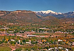 Durango as seen from Rim Drive. | |
| Motto(s): "Open Spaces and Familiar Faces" | |
 Location of the City of Durango in La Plata County, Colorado. | |
 Durango Location of the City of Durango in the United States. | |
| Coordinates: 37°16′24″N 107°52′18″W / 37.273267°N 107.871692°WCoordinates: 37°16′24″N 107°52′18″W / 37.273267°N 107.871692°W[2] | |
| Country | |
| State | |
| County | La Plata County[3] |
| City | Durango[1] |
| Founded | 1880 |
| Incorporated | April 27, 1881[4] |
| Government | |
| • Type | Home rule municipality[1] |
| • Mayor | Dean Brookie[5] |
| • Mayor Pro Tempore | Kim Baxter[5] |
| • City Manager | Jose Madrigal[8] |
| • City Council | Barbara Noseworthy Chris Bettin |
| Area | |
| • Total | 17.103 sq mi (44.296 km2) |
| • Land | 14.708 sq mi (38.093 km2) |
| • Water | 2.395 sq mi (6.203 km2) |
| Population | |
| • Total | 19,071 |
| • Density | 1,297/sq mi (501/km2) |
| • Metro | 55,638 |
| Demonym(s) | Durangoan |
| Time zone | UTC−07:00 (MST) |
| • Summer (DST) | UTC−06:00 (MDT) |
| ZIP codes[7] | 81301-81303 |
| Area code(s) | 970 |
| FIPS code | 08-22035 |
| GNIS feature ID | 0202983 |
| Website | City of Durango |

The City of Durango is the home rule municipality that is the county seat and the most populous municipality of La Plata County, Colorado, United States.[1] The city population was 19,071 at the 2020 United States Census.[6] Durango is the home of Fort Lewis College.
History[]
The town was organized from September 1880 to April 1881 by the Denver and Rio Grande Railroad (D&RG, later known as the Denver and Rio Grande Western railroad) as part of their efforts to reach Silverton, Colorado, and service the San Juan mining district, the goal of their "San Juan Extension" built from Alamosa Colorado. The D&RG chose a site in the Animas Valley close to the Animas River near what's now the Downtown Durango Historic Business District for its railroad facilities following a brief and most likely perfunctory negotiation with the other establishment in the area known as Animas City, two miles to the north.[9] The city was named by ex-Colorado Governor Alexander C. Hunt, a friend of D&RG President William Jackson Palmer, after Durango, Mexico, based on his favorable impression of that city resulting from a scouting trip undertaken on behalf of Palmer.[10]
Palmer among other D&RG associates such as William Bell started a subsidiary company known as the Durango Trust to sell land and plan a Main Street, 2nd, and 3rd Avenue, and so on to organize the town, taking inspiration from how Palmer founded the city of Colorado Springs. Sales from the Durango Trust skyrocketed by the completion of the D&RG's Silverton Branch, by 1885 Durango’s business district had seven hotels and restaurants, eleven saloons, dancehalls and stores, two bakeries and blacksmith shops, and a variety of other businesses, also boosting the town of Silverton’s population to 2,000 at the time.[10]
The D&RG(W) and the Rio Grande Southern Railroad were vital resources to many places including Durango before the major introduction of the automobile, helping transport goods such as produce and mineral traffic in and out of the Southwestern Colorado area, along with other businesses such as the Durango Smelter, immensely supporting the town's economy. However, the Great Depression and aftermath of World War II ended up hurting the area's railroad industry, resulting in the Rio Grande Southern losing most of its traffic in 1951, which later closed and removed from 1952-3. The D&RGW ended their San Juan Express passenger service from Durango to Alamosa as well. However, the natural scenery along their Silverton Branch had been recognized as a major tourist attraction. In turn, the D&RGW introduced the major tourism industry into the Durango area, transporting visitors up to Silverton and back and attracting Hollywood into La Plata County for a time. Once the D&RGW ended up losing its freight traffic in 1968, the tracks from Durango east to Chama, New Mexico, and south to Farmington, New Mexico were removed, but the Silverton Branch remained in operation until 1981 when it was sold and became the Durango & Silverton Narrow Gauge Railroad.[10][11]
There are significant archaeological sites surrounding the Durango area featured on the State and National historical registers, including:
- Mesa Verde National Park, a World Heritage site
- Chimney Rock National Monument, the most northeastern known outpost of the Ancestral Puebloans
- Durango Rock Shelters Archeology Site, a Basketmaker and Pueblo culture
- Spring Creek Archeological District, a Basketmaker and Pueblo site
- Talus Village, a Basketmaker site
Geography[]
Durango is located at 37°16′N 107°52′W / 37.267°N 107.867°W at an elevation of 6,512 ft (1,988 m). At the 2020 United States Census, the town had a total area of 10,946 acres (44.296 km2) including 1,533 acres (6.203 km2) of water.[6]
Climate[]
According to the Köppen climate classification system, Durango has either a warm-summer Mediterranean climate (Csb) or a humid continental climate (Dsb) depending on which variant of the system is used. The average annual precipitation is 19.33 in (491 mm).[12] Its hardiness zone is 5b.[13]
| Durango (1971-2000 normals) | ||||||||||||||||||||||||||||||||||||||||||||||||||||||||||||
|---|---|---|---|---|---|---|---|---|---|---|---|---|---|---|---|---|---|---|---|---|---|---|---|---|---|---|---|---|---|---|---|---|---|---|---|---|---|---|---|---|---|---|---|---|---|---|---|---|---|---|---|---|---|---|---|---|---|---|---|---|
| Climate chart (explanation) | ||||||||||||||||||||||||||||||||||||||||||||||||||||||||||||
| ||||||||||||||||||||||||||||||||||||||||||||||||||||||||||||
| ||||||||||||||||||||||||||||||||||||||||||||||||||||||||||||
| hideClimate data for Durango, Colorado, 1991–2015 normals, extremes 1894–present | |||||||||||||
|---|---|---|---|---|---|---|---|---|---|---|---|---|---|
| Month | Jan | Feb | Mar | Apr | May | Jun | Jul | Aug | Sep | Oct | Nov | Dec | Year |
| Record high °F (°C) | 65 (18) |
71 (22) |
78 (26) |
84 (29) |
98 (37) |
98 (37) |
102 (39) |
99 (37) |
96 (36) |
87 (31) |
74 (23) |
64 (18) |
102 (39) |
| Average high °F (°C) | 40.9 (4.9) |
45.8 (7.7) |
54.9 (12.7) |
62.7 (17.1) |
72.2 (22.3) |
81.5 (27.5) |
86.0 (30.0) |
83.6 (28.7) |
76.4 (24.7) |
65.0 (18.3) |
50.6 (10.3) |
40.9 (4.9) |
63.4 (17.4) |
| Average low °F (°C) | 14.5 (−9.7) |
19.4 (−7.0) |
25.8 (−3.4) |
31.2 (−0.4) |
39.3 (4.1) |
47.1 (8.4) |
54.5 (12.5) |
53.1 (11.7) |
45.4 (7.4) |
34.6 (1.4) |
23.2 (−4.9) |
15.3 (−9.3) |
33.6 (0.9) |
| Record low °F (°C) | −30 (−34) |
−27 (−33) |
−9 (−23) |
0 (−18) |
15 (−9) |
16 (−9) |
33 (1) |
31 (−1) |
20 (−7) |
5 (−15) |
−14 (−26) |
−21 (−29) |
−30 (−34) |
| Average precipitation inches (mm) | 2.30 (58) |
1.79 (45) |
1.42 (36) |
1.53 (39) |
1.16 (29) |
0.57 (14) |
1.77 (45) |
2.81 (71) |
2.19 (56) |
2.02 (51) |
1.64 (42) |
1.75 (44) |
20.95 (530) |
| Average snowfall inches (cm) | 19.9 (51) |
14.9 (38) |
6.0 (15) |
3.7 (9.4) |
0.2 (0.51) |
0.0 (0.0) |
0.0 (0.0) |
0.0 (0.0) |
0.0 (0.0) |
1.1 (2.8) |
5.7 (14) |
13.2 (34) |
64.7 (164.71) |
| Source: [14] | |||||||||||||
Demographics[]
| Historical population | |||
|---|---|---|---|
| Census | Pop. | %± | |
| 1890 | 2,726 | — | |
| 1900 | 3,317 | 21.7% | |
| 1910 | 4,686 | 41.3% | |
| 1920 | 4,116 | −12.2% | |
| 1930 | 5,400 | 31.2% | |
| 1940 | 5,887 | 9.0% | |
| 1950 | 7,459 | 26.7% | |
| 1960 | 10,530 | 41.2% | |
| 1970 | 10,333 | −1.9% | |
| 1980 | 11,649 | 12.7% | |
| 1990 | 12,430 | 6.7% | |
| 2000 | 13,922 | 12.0% | |
| 2010 | 16,887 | 21.3% | |
| 2020 | 19,071 | 12.9% | |
| U.S. Decennial Census | |||
As of the 2000 census,[15] there were 13,922 people, 5,492 households, and 2,603 families residing in the city. The population density was 2,052.4 people per square mile (792.8/km2). There were 5,819 housing units at an average density of 857.8 per square mile (331.4/km2). The racial makeup of the city was 86.8% White, 0.5% African American, 5.5% Native American, 0.7% Asian, 0.1% Pacific Islander, 4.1% from other races, and 2.2% from two or more races. Hispanic or Latino of any race were 10.3% of the population.
There were 5,492 households, out of which 22.4% had children under the age of 18 living with them, 34.2% were married couples living together, 9.4% had a single female householder, and 52.6% were non-families. 31.8% of all households were made up of individuals, and 9.0% had someone living alone who was 65 years of age or older. The average household size was 2.23 and the average family size was 2.83.
In the city, 16.6% of residents were under the age of 18, 26.1% from 18 to 24, 27.2% from 25 to 44, 19.4% from 45 to 64, and 10.7% who were 65 years of age or older. The median age was 29 years. For every 100 females, there were 104.1 males. For every 100 females age 18 and over, there were 103.8 males.
The median income for a household in the city was $34,892, and the median income for a family was $50,814. Males had a median income of $31,812 versus $25,022 for females. The per capita income for the city was $19,352. 17.2% of the population and 7.3% of families were living below the poverty line. 11.2% of those younger than 18 and 8.9% of those 65 and older were living below the poverty line.
Arts and culture[]
Attractions[]
Main Avenue[]

Main Avenue is a Nationally Registered Historic District that cuts through downtown Durango and is home to galleries, boutiques, restaurants, bars, and other businesses. Two notable and historic hotels, The General Palmer and The Strater, lie at the south end of the avenue, near the Durango & Silverton Narrow Gauge Railroad depot. With its combination of historic architecture, entertainment, and shopping, Main Avenue has historically comprised the center of Durango and is a popular year-round tourist destination.
Durango & Silverton Narrow Gauge Railroad[]
Durango is known worldwide for the Durango & Silverton Narrow Gauge Railroad, a heritage railroad that operates what was the Denver & Rio Grande Western's Branchline to the historic mining town of Silverton, Colorado, also still notably using historic D&RGW Steam Locomotives and other historic rail equipment.
Animas River Valley[]
The Animas River Valley begins in the heart of the San Juan Mountains and runs through downtown Durango. It boasts gold medal fly fishing waters and is popular for whitewater rafting, kayaking and canoeing. On warm summer afternoons a popular diversion is to buy an inflated inner tube and float from Animas City to Schneider Park or below.

Purgatory Ski Resort[]
Purgatory Resort, located 25 miles north of downtown Durango, has 99 trails, 12 lifts, a vertical drop of over 2,000 feet, and more than 1,500 acres of skiable terrain. The resort features lodging, ski rentals, shopping, and dining. Purgatory is also a popular summertime recreation destination.
Snowdown Festival[]
Durango is home to Snowdown, an annual midwinter event popular for its Parade of Lights and other events. The event lasts 5 days, with competitions and costumes.
Music in the Mountains[]
Music in the Mountains is an annual classical summer music festival with performances at Purgatory Resort, Ft. Lewis College, in downtown Durango, and Cortez.
As of 2019, the festival is no longer being held at Purgatory Resort.
Durango Ragtime & Early Jazz Festival[]
The annual Durango Ragtime & Early Jazz Festival features noted musicians from around the country. It is held in the Strater Hotel, a historic Victorian hotel in Durango.
Iron Horse Bicycle Classic[]
Founded in 1972, the Iron Horse is a 61 mile bicycle road race held annually in Durango, CO. Every year cyclist from around the world come together and race the Durango Narrow Gauge Train on its journey from Durango to Silverton.
Media[]
Durango has a number of media outlets, which include The Durango Herald, 99x Durango, The Point, KDGO, XRock 105.3, KDUR 91.9/93.9, Four Corners Broadcasting (KIQX 101.3, KRSJ 100.5, KKDC 93.3, and KKDC AM 930) and many others.
Infrastructure[]
Public Transportation[]
Durango is served by U.S. Highway 160 (the Old Spanish Trail), running east–west, and U.S. Highway 550, running north–south. Part of U.S. 550 offers high-speed access (primarily a 4-lane, divided highway) to Albuquerque, New Mexico. North of Durango, 550 is nicknamed the Million Dollar Highway, and is part of the scenic San Juan Skyway.
Durango is served by a major regional airport for southwestern Colorado, Durango-La Plata Regional Airport, near Ignacio. Durango-La Plata County Airport (IATA code: DRO) is serviced year-round by regional carriers Mesa Airlines (American Eagle), SkyWest Airlines (American Eagle and United Express), Republic Airways (United Express), and American Eagle (Envoy Air).
As of 2014, regional connecting hubs to DRO include Dallas/Fort Worth International Airport (DFW), Phoenix Sky Harbor International Airport (PHX), and Denver International Airport (DEN).
Durango Transit provides several loop bus routes in the community, including Fort Lewis College. Normal hours of operation are weekdays from 6:30 am to 6:30 pm. Ignacio Road Runner provides bus service to the nearby towns of Ignacio, Colorado and Bayfield, with four trips daily on weekdays and one on Saturdays. Both services share the Durango Transit Center as a hub.
Greyhound Bus Lines formerly served Durango, but after budget cuts the service was discontinued. Since 2014, Road Runner Transit (a service of Southern Ute Community Action Programs) has restored daily bus service between Grand Junction and Durango.[16] Since 2018, Road Runner's service has been incorporated into the larger mantle of the state-run program Bustang.[17]
Colleges[]
- Fort Lewis College is on a 350 foot (110 m) mesa overlooking downtown Durango and is accredited by the Higher Learning Commission. As of 2014, 4,028 students were enrolled at FLC.[18] FLC is a public 4-year liberal arts college.
- Southwest Colorado Community College, a branch of Pueblo Community College, is in the Durango Highschool building on North Main Ave.
Notable people[]
This section does not cite any sources. (February 2013) |
- Paco Ahlgren, writer
- Ross Anderson, World Cup/professional speed skier, All-American record holder
- Steve Carlton, Baseball Hall of Fame pitcher
- James Garesche Ord, United States Army Major General, born at Fort Lewis near Durango
- Missy Giove, cyclist inducted into the Mountain Bike Hall of Fame
- Howard Grotts, cyclist
- Greg Herbold, cyclist inducted into the Mountain Bike Hall of Fame
- Sepp Kuss, cyclist Tour de France stage winner
- Matt Miller, NFL offensive tackle for the Cleveland Browns
- Ned Overend, cyclist inducted into the Mountain Bike Hall of Fame and the United States Bicycling Hall of Fame
- Stuart Roosa, NASA astronaut and former USFS Smoke Jumper, carried Redwood seeds on the Apollo 14 Moon mission which are now planted in several US parks
- Quinn Simmons, cyclist
- Ed Stasium, record producer
- Tom Tully, actor, Oscar nominee for The Caine Mutiny
- Shan Wells, sculptor and illustrator
- Todd Wells, cyclist
Sister cities[]
Durango has two sister cities, as designated by Sister Cities International:
 Durango, Mexico
 Durango, Spain
References in television and film[]
The Denver & Rio Grande Western Railroad began to advertise the La Plata County Area to Hollywood beginning in the mid 1930s, kick starting Durango's future in film appearances.[19]
- Parts of the 1948 film Colorado Territory were filmed in the Durango area including the Railroad Depot and the D&RGW's railroad line south to Farmington, New Mexico.[19][20]
- The 1950 Film A Ticket to Tomahawk was shot primarily in the La Plata County area involving the D&RGW's Silverton Branch (later to become the Durango & Silverton Narrow Gauge Railroad), filmed north of Durango, Silverton, Colorado, on the current site of Fort Lewis College, as well as a shot of a Rio Grande Southern Railroad Trestle located west of Durango near Wild Cat Canyon. This was one of Marilyn Monroe's first onscreen appearances as well.[19][21]
- Much of the 1952 film Denver and Rio Grande was shot on whats now the D&RGW's Silverton Branch, retelling the story of the D&RG's battle for rights into the Royal Gorge, against the Atchison, Topeka and Santa Fe Railroad.[19][22]
- Much of the 1953 western movie The Naked Spur starring James Stewart was shot in Durango.[23]
- Several parts of the 1955 western film Run for Cover starring James Cagney, were filmed just north of Durango in and around the upper Hermosa Valley area. Includes shots of the D&RGW Silverton Branch as well.[24]
- Portions of the 1957 western Night Passage starring a returning James Stewart, as well as Audie Murphy and Brandon DeWilde were filmed near Durango and on the D&RGW's Silverton Branch.[25]
- In 1965, Rosemary DeCamp played Durango newspaper editor Caroline Romney in the episode, "Mrs. Romney and the Outlaws" of the syndicated television series, Death Valley Days. In the story line, Romney sounds the alarm for citizens to fight the Kimball/Sykes gang. Willard Sage played Marshal Christy.[26]
- Parts of the 1969 film Butch Cassidy and the Sundance Kid were filmed north of town along the Animas River, as well as scenes of the D&RGW Railroad on the Silverton branch, and southeast of Durango near Florida, as well as other locations on the D&RGW narrow gauge system.[27][19]
- The 1978 Roger Corman film Avalanche, starring Rock Hudson and Mia Farrow, was filmed mainly at Durango Mountain Resort and at the Lodge at Tamarron in north Durango.[28]
- The television series Cannon, episode "Sky Above, Death Below" was filmed in and around Durango, Purgatory Resort, and Chimney Rock.[29]
- Part of the 1991 film City Slickers was shot in Durango.[30]
- The 1999 movie Durango Kids describes a time tunnel in the old mines outside of Durango.[31]
- Parts of the 1993 film Cliffhanger were shot in Durango.[32]
See also[]
- Colorado
- Bibliography of Colorado
- Index of Colorado-related articles
- Outline of Colorado
- List of places in Colorado
- Colorado metropolitan areas
- Durango, CO Micropolitan Statistical Area
- Durango & Silverton Narrow-Gauge Railroad
- Durango Herald
- Durango Telegraph
- Old Spanish National Historic Trail
References[]
- ^ Jump up to: a b c d e "Active List of municipalities in Colorado". State of Colorado, Colorado Department of Local Affairs, Division of Local Government. Retrieved January 26, 2021.
- ^ "2014 U.S. Gazetteer Files: Places". United States Census Bureau. July 1, 2014. Retrieved January 5, 2015.
- ^ "Colorado Counties". State of Colorado, Colorado Department of Local Affairs, Division of Local Government. Retrieved January 26, 2021.
- ^ "Colorado Municipal Incorporations". State of Colorado, Department of Personnel & Administration, Colorado State Archives. 2004-12-01. Retrieved 2007-09-02.
- ^ Jump up to: a b c "Current City Council". City of Durango.
- ^ Jump up to: a b c d "Decennial Census P.L. 94-171 Redistricting Data". United States Census Bureau, United States Department of Commerce. August 12, 2021. Retrieved September 7, 2021.
- ^ "ZIP Code Lookup". United States Postal Service. Archived from the original (JavaScript/HTML) on November 4, 2010. Retrieved September 8, 2007.
- ^ "Current City Council". City of Durango. Archived from the original on 2010-11-22.
- ^ Nossaman, Allen (19998). Many More Mountains Vol. 3: Rails into Silverton.
- ^ Jump up to: a b c Smith, Duane A. (1992). Rocky Mountain boom town : a history of Durango, Colorado. Niwot, Colo.: University Press of Colorado. ISBN 0-585-02503-7. OCLC 44959038.
- ^ Dorman, Richard L. (1987). Durango: always a railroad town (1st ed.). Santa Fe, NM: R.D. Publications. ISBN 0-9616656-1-0. OCLC 17515710.
- ^ Jump up to: a b "DURANGO, COLORADO - Climate Summary". Wrcc.dri.edu. Retrieved 27 August 2017.
- ^ "Zipcode 81301 - Durango, Colorado Hardiness Zones". Plantmaps.com. Retrieved 27 August 2017.
- ^ "DURANGO, COLORADO (052441)". Western Regional Climate Center. Retrieved June 3, 2016.
- ^ "U.S. Census website". United States Census Bureau. Retrieved 2008-01-31.
- ^ Dale Rodebaugh (July 11, 2014). "Bus service to Grand Junction to resume". Durango Herald. Retrieved 27 August 2017.
- ^ Armijo, Patrick (December 31, 2017). "Road Runner bus line to join state network". The Durango Herald.
- ^ "College in Colorado - Facts about Fort Lewis College". Fortlewis.edu. Retrieved 27 August 2017.
- ^ Jump up to: a b c d e Jensen, Larry (2014). Hollywood's railroads : volume three, Narrow Gauge Country. [Sequim, WA]. ISBN 978-0-692-31351-0. OCLC 967732272.
- ^ Colorado Territory (1949) - IMDb, retrieved 2021-03-30
- ^ A Ticket to Tomahawk (1950) - IMDb, retrieved 2021-03-30
- ^ Denver & Rio Grande (1952) - IMDb, retrieved 2021-03-30
- ^ "The Naked Spur (1953)". IMDb. Retrieved 27 August 2017.[unreliable source?]
- ^ "Run for Cover (1955)". IMDb. Retrieved 27 August 2017.[unreliable source?]
- ^ "Night Passage (1957)". IMDb. Retrieved 27 August 2017.[unreliable source?]
- ^ "Mrs. Romney and the Outlaws". Internet Movie Data Base. December 23, 1965. Retrieved September 1, 2015.[unreliable source?]
- ^ "Butch Cassidy and the Sundance Kid (1969)". IMDb. Retrieved 27 August 2017.[unreliable source?]
- ^ "Avalanche (1978)". IMDb. Retrieved 22 August 2019.[unreliable source?]
- ^ IMDB: Cannon: Sky Above, Death Below , television series.[unreliable source?]
- ^ IMDB: City Slickers (1991) - Filming locations[unreliable source?]
- ^ IMDB: Durango Kids, motion picture.[unreliable source?]
- ^ "Cliffhanger (1993)". IMDb. Retrieved 27 August 2017.[unreliable source?]
External links[]
 Media from Wikimedia Commons
 Travel guides from Wikivoyage
| show Municipalities and communities of La Plata County, Colorado, United States |
|---|

| hide | ||
|---|---|---|
Denver (capital) | ||
| Topics |
|  |
| Society | ||
| Cities |
| |
| Counties |
| |
| Regions |
| |
| show Authority control |
|---|
- Durango, Colorado
- Cities in La Plata County, Colorado
- Cities in Colorado
- County seats in Colorado
- Company towns in Colorado
- Populated places established in 1881
- 1881 establishments in Colorado