Hermosa, Colorado
Hermosa | |
|---|---|
Unincorporated community | |
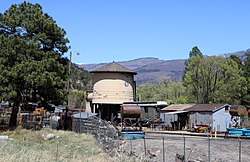 The D&SNG water tank along Highway 550 | |
| Etymology: From the Spanish word hermosa, meaning beautiful[1] | |
 Hermosa Location within the state of Colorado | |
| Coordinates: 37°24′55″N 107°50′07″W / 37.41528°N 107.83528°WCoordinates: 37°24′55″N 107°50′07″W / 37.41528°N 107.83528°W[2] | |
| Country | |
| State | |
| County | La Plata County |
| Elevation | 6,644 ft (2,025 m) |
| Time zone | UTC-7 (MST) |
| • Summer (DST) | UTC-6 (MDT) |
| ZIP code | 81301 |
| Area code(s) | 970 |

Hermosa is an unincorporated community in La Plata County, Colorado. It is located north of Durango along U.S. Highway 550.[1]
Attractions[]
The Durango and Silverton Narrow Gauge Railroad has a water stop in Hermosa, and the railroad maintains a maintenance yard and a siding there, which is sometimes called the Hermosa Depot. The yard has a prominent railroad water tank that is easily seen by motorists passing through Hermosa on Highway 550.
Hermosa Creek passes through the community from west to east and has its confluence with the Animas River nearby.
The Hermosa Cliffs,[3] formed of red sandstone, line the river valley in Hermosa.
History[]
The community was established around 1874[1] and had a post office from 1876 to 1900.[4] Residents are now served by post offices in Durango.
In 2018, the 416 Fire burned northwest of Hermosa, prompting evacuations.
See also[]
References[]
- ^ a b c d Bright, William (2004). Colorado place names (Third ed.). Boulder: Johnson Books. p. 85. ISBN 1555663338. LCCN 2003024331.
- ^ a b "Hermosa". Geographic Names Information System. United States Geological Survey. Retrieved 2020-05-04.
- ^ "Hermosa Cliffs". Geographic Names Information System. United States Geological Survey. Retrieved 2020-05-04.
- ^ "Post offices". Jim Forte Postal History. Retrieved 2020-05-04.
Municipalities and communities of La Plata County, Colorado, United States | ||
|---|---|---|
| City |  | |
| Towns | ||
| CDPs | ||
| Unincorporated communities | ||
| Indian reservations | ||
| Footnotes | ‡This populated place also has portions in an adjacent county or counties | |
| ||
- Unincorporated communities in La Plata County, Colorado
- Unincorporated communities in Colorado