[3] Name on the Register
Image
Date listed[4]
Location
City or town
Description
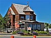
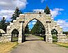
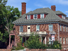
1
Algeria Shrine Temple
April 14, 1988 (#88000434 ) Neill and Park Aves. 46°35′43″N 112°02′21″W / 46.595278°N 112.039167°W / 46.595278; -112.039167 (Algeria Shrine Temple ) Helena
2
Alice Creek Historic District
June 6, 2007 (#06000531 ) Helena National Forest [5] 47°08′22″N 112°27′30″W / 47.139444°N 112.458333°W / 47.139444; -112.458333 (Alice Creek Historic District ) Lincoln
3
November 7, 1995 (#95001264 ) 1999 Euclid Ave. 46°36′20″N 112°03′52″W / 46.605556°N 112.064444°W / 46.605556; -112.064444 (Appleton House No. 9 ) Helena
4
October 25, 1982 (#82000593 ) 2200 Cannon 46°36′24″N 112°04′05″W / 46.606667°N 112.068056°W / 46.606667; -112.068056 (Appleton House No. 13 ) Helena
5
Upload image May 10, 2005 (#05000408 ) 1117 E. Broadway 46°35′04″N 112°01′13″W / 46.584444°N 112.020278°W / 46.584444; -112.020278 (Joshua and Martha Armitage House ) Helena
6
Benton Avenue Cemetery
July 24, 2003 (#03000689 ) 1800 N. Benton Ave. 46°36′16″N 112°02′31″W / 46.604444°N 112.041944°W / 46.604444; -112.041944 (Benton Avenue Cemetery ) Helena
7
Upload image August 27, 2008 (#08000825 ) 1104 Williams St. 46°36′21″N 112°05′19″W / 46.605703°N 112.088561°W / 46.605703; -112.088561 (Charles A. Broadwater House ) Helena
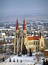
8
Cathedral of Saint Helena
April 30, 1980 (#80004270 ) 530 N. Ewing St. 46°35′25″N 112°01′57″W / 46.590278°N 112.0325°W / 46.590278; -112.0325 (Cathedral of Saint Helena ) Helena
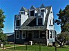
9
November 7, 1995 (#95001263 ) 318 E. 6th Ave. 46°35′15″N 112°02′00″W / 46.5875°N 112.033333°W / 46.5875; -112.033333 (Childs Carriage House ) Helena
10
May 30, 1997 (#97000502 ) 535 5th Ave. 46°35′09″N 112°01′50″W / 46.585833°N 112.030556°W / 46.585833; -112.030556 (William C. Crum House ) Helena
11
April 24, 2017 (#100000914 ) 1003 9th Ave. 46°35′19″N 112°01′25″W / 46.588725°N 112.023685°W / 46.588725; -112.023685 (Crump-Howard House ) Helena
12
May 4, 1995 (#95000536 ) 602 N. Ewing 46°35′28″N 112°01′53″W / 46.591111°N 112.031389°W / 46.591111; -112.031389 (D.H. Cuthbert House ) Helena
13
Dearborn River High Bridge
December 18, 2003 (#03001298 ) 15 miles (24 km) southwest of Augusta on Bean Lake Rd. 47°16′52″N 112°23′25″W / 47.281111°N 112.390278°W / 47.281111; -112.390278 (Dearborn River High Bridge ) Augusta
14
December 28, 2005 (#05001471 ) 46 S. Howie St. 46°35′14″N 112°02′38″W / 46.587222°N 112.043889°W / 46.587222; -112.043889 (Donovan-Mayer House ) Helena
15
April 24, 2017 (#100000915 ) 401 N. Hoback St. 46°35′17″N 112°01′32″W / 46.588000°N 112.025637°W / 46.588000; -112.025637 (Dorsey Grocery and Residence ) Helena
16
Upload image October 7, 1993 (#93000995 ) Address Restricted Helena part of the Archeological Resources of the Upper Missouri River Corridor Multiple Property Submission (MPS)
17
Christmas Gift Evans House
April 16, 1980 (#80004271 ) 404 N. Benton Ave. 46°35′27″N 112°02′27″W / 46.590833°N 112.040833°W / 46.590833; -112.040833 (Christmas Gift Evans House ) Helena
18
Robert and Elizabeth Fisk House
January 17, 2007 (#06001248 ) 319 N. Rodney St. 46°35′15″N 112°01′56″W / 46.5875°N 112.032222°W / 46.5875; -112.032222 (Robert and Elizabeth Fisk House ) Helena
19
Forestvale Cemetery
February 21, 1990 (#90000145 ) 490 Forestvale Rd. 46°39′22″N 112°02′09″W / 46.656111°N 112.035833°W / 46.656111; -112.035833 (Forestvale Cemetery ) Helena
20
Former Montana Executive Mansion
April 28, 1970 (#70000357 ) 6th Ave. and Ewing St. 46°35′16″N 112°02′03″W / 46.587778°N 112.034167°W / 46.587778; -112.034167 (Former Montana Executive Mansion ) Helena
21
Upload image December 20, 2016 (#16000874 ) 2 mi. NW. of Helena 46°37′05″N 112°06′06″W / 46.618004°N 112.101554°W / 46.618004; -112.101554 (Fort Harrison Veterans' Hospital Historic District ) Helena vicinity
22
Upload image August 28, 2017 (#100001504 ) 5488 Lincoln Rd. W. 46°43′31″N 112°08′28″W / 46.725372°N 112.141245°W / 46.725372; -112.141245 (Gehring Ranch ) Helena vicinity
23
Upload image December 1, 1983 (#83003993 ) Main St. 47°30′35″N 112°21′34″W / 47.509722°N 112.359444°W / 47.509722; -112.359444 (Gilman State Bank ) Gilman
24
August 10, 2005 (#05000883 ) 604 Dearborn Ave. 46°35′35″N 112°02′32″W / 46.593056°N 112.042222°W / 46.593056; -112.042222 (Gilpatrick-Root House ) Helena
25
March 14, 2014 (#14000080 ) 502 Peosta Ave. 46°36′09″N 112°02′30″W / 46.602494°N 112.041593°W / 46.602494; -112.041593 (Haight-Bridgewater House ) Helena
26
Hauser Mansion
February 12, 1979 (#79001404 ) 720 Madison Ave. 46°35′43″N 112°02′39″W / 46.595278°N 112.044167°W / 46.595278; -112.044167 (Hauser Mansion ) Helena
27
Helena Historic District
June 2, 1972 (#72000737 ) Irregular pattern from Hauser Boulevard to Acropolis and between Garfield and Rodney Sts.; also roughly bounded by Cruse, Neill and Park Aves., and Lawrence; also bounded by E. 6th, N. Davis, Broadway, and N. Rodney Sts. 46°34′34″N 112°02′26″W / 46.576111°N 112.040556°W / 46.576111; -112.040556 (Helena Historic District ) Helena Second and third sets of boundaries represent boundary increases of June 14, 1990 and October 7, 1993
28
December 15, 2004 (#03001330 ) Roughly bounded by Railroad and Helena Aves., Gallatin St., N. Sanders St., and N. Harris St. 46°35′58″N 112°00′52″W / 46.599444°N 112.014444°W / 46.599444; -112.014444 (Helena Railroad Depot Historic District ) Helena
29
Helena South-Central Historic District
July 28, 1986 (#86002274 ) Roughly bounded by Broadway, S. Davis St., the city limits, and S. Warren St. 46°34′52″N 112°02′15″W / 46.581111°N 112.0375°W / 46.581111; -112.0375 (Helena South-Central Historic District ) Helena
30
February 22, 1996 (#96000119 ) 500-600 blocks of W. Main St. 46°34′43″N 112°03′03″W / 46.578611°N 112.050833°W / 46.578611; -112.050833 (Helena West Main Street Historic District ) Helena
31
August 31, 2001 (#01000922 ) Sleeping Giant Ranch, 20 miles (32 km) north of Helena[6] 46°49′30″N 111°57′44″W / 46.825°N 111.962222°W / 46.825; -111.962222 (Joe and Carrie Hilger Ranch ) Helena
32
Home of Peace
May 24, 2006 (#06000425 ) Alexander St. between Brady St. and Custer Ave. 46°36′53″N 112°03′01″W / 46.614722°N 112.050278°W / 46.614722; -112.050278 (Home of Peace ) Helena
33
December 23, 1993 (#93001448 ) Area surrounding the junction of 9th Ave. and N. Hoback St. 46°35′15″N 112°01′30″W / 46.5875°N 112.025°W / 46.5875; -112.025 (House of the Good Shepherd Historic District ) Helena
34
December 26, 2012 (#12001086 ) 511 E. 6th Ave. 46°35′11″N 112°01′54″W / 46.586488°N 112.03157°W / 46.586488; -112.03157 (John H. Huseby House ) Helena
35
Upload image August 18, 1992 (#92001056 ) 635 1st St. 46°34′47″N 112°01′45″W / 46.579722°N 112.029167°W / 46.579722; -112.029167 (Herman Kemna House ) Helena
36
T. H. Kleinschmidt House
August 6, 1980 (#80004272 ) 1823 Highland Ave. 46°34′58″N 112°00′25″W / 46.582778°N 112.006944°W / 46.582778; -112.006944 (T. H. Kleinschmidt House ) Helena
37
Kluge House
April 28, 1970 (#70000358 ) 540 W. Main St. 46°35′22″N 111°55′47″W / 46.58948°N 111.9297°W / 46.58948; -111.9297 (Kluge House ) Helena
38
Lewis and Clark County Hospital Historic District
November 19, 2002 (#02001101 ) 3404 Cooney Dr. 46°37′20″N 112°02′12″W / 46.622222°N 112.036667°W / 46.622222; -112.036667 (Lewis and Clark County Hospital Historic District ) Helena Old Cooney Home
39
January 22, 1987 (#86003674 ) Montana Highway 200 46°57′20″N 112°41′11″W / 46.955556°N 112.686389°W / 46.955556; -112.686389 (Lincoln Community Hall ) Lincoln
40
Lincoln Lodge
October 23, 1986 (#86002931 ) Stemple Pass Rd. 46°57′23″N 112°40′50″W / 46.956389°N 112.680556°W / 46.956389; -112.680556 (Lincoln Lodge ) Lincoln
41
March 29, 2019 (#100003590 ) 309 N. Rodney St. 46°35′15″N 112°02′00″W / 46.5874°N 112.0334°W / 46.5874; -112.0334 (Lyman-Neel Residence ) Helena
42
Upload image April 12, 2021 (#100006367 ) 210 Main St. Coordinates missing
Helena
43
Mann Gulch Wildfire Historic District
May 19, 1999 (#99000596 ) Mann Gulch, a tributary of the Missouri River 46°53′09″N 111°53′58″W / 46.8858°N 111.8994°W / 46.8858; -111.8994 (Mann Gulch Wildfire Historic District ) Helena
44
Methodist-Episcopal Church of Marysville Upload image January 5, 1984 (#84002489 ) 3rd St. 46°45′05″N 112°17′58″W / 46.7514°N 112.2994°W / 46.7514; -112.2994 (Methodist-Episcopal Church of Marysville ) Marysville
45
January 4, 2010 (#09001181 ) Milepost 11 on Old U.S. Route 91 47°01′08″N 112°00′44″W / 47.0190°N 112.0121°W / 47.0190; -112.0121 (Missouri River Bridge ) Wolf Creek part of the Montana's Historic Steel Truss Bridges MPS
46
July 31, 2017 (#100001392 ) 2630 Airport Rd. 46°36′09″N 111°59′35″W / 46.6025°N 111.9931°W / 46.6025; -111.9931 (Montana Aeronautics Commission Operations Historic District ) Helena Original 1958 Structure and adjacent 1965 garage.
47
February 14, 2002 (#02000048 ) 1100 N. Main 46°35′54″N 112°01′55″W / 46.5982°N 112.0319°W / 46.5982; -112.0319 (Montana State Arsenal, Armory and Drill Hall ) Helena
48
Montana State Capitol Building
February 17, 1981 (#81000660 ) Central Ave. and Main St. 46°35′09″N 112°01′12″W / 46.5858°N 112.02°W / 46.5858; -112.02 (Montana State Capitol Building ) Helena
49
February 23, 2016 (#16000033 ) Bounded by E. Broadway & N. Carson Sts., E. 8th & N. Montana Aves. 46°35′06″N 112°01′07″W / 46.5850°N 112.0186°W / 46.5850; -112.0186 (Montana State Capitol Campus Historic District ) Helena
50
Montana State Fairgrounds Racetrack Upload image December 20, 2006 (#06001136 ) 98 W. Custer Ave. 46°37′17″N 112°03′22″W / 46.6214°N 112.0561°W / 46.6214; -112.0561 (Montana State Fairgrounds Racetrack ) Helena
51
Montana Veterans and Pioneers Memorial Building
December 15, 2004 (#04001357 ) 225 N. Roberts 46°35′11″N 112°00′55″W / 46.5864°N 112.0153°W / 46.5864; -112.0153 (Montana Veterans and Pioneers Memorial Building ) Helena
52
Mount Helena Historic District
January 9, 1997 (#96001568 ) Promontory roughly bounded by LeGrande Canon Boulevard, Last Chance and Grizzly Gulches, and the Helena National Forest boundary 46°35′15″N 112°03′28″W / 46.5875°N 112.0578°W / 46.5875; -112.0578 (Mount Helena Historic District ) Helena
53
August 1, 1984 (#84002495 ) 418 N. Benton Ave. 46°35′28″N 112°02′25″W / 46.5911°N 112.0403°W / 46.5911; -112.0403 (John T. Murphy House ) Helena
54
Olsen House
March 22, 1991 (#91000333 ) 516 N. Park 46°35′33″N 112°02′23″W / 46.5925°N 112.0397°W / 46.5925; -112.0397 (Olsen House ) Helena
55
June 27, 2007 (#07000591 ) 327 N. Rodney 46°35′16″N 112°01′55″W / 46.5878°N 112.0319°W / 46.5878; -112.0319 (Francis and Hannah Pope House ) Helena
56
Porter Flats Apartments
January 14, 1993 (#92001761 ) 335 N. Ewing St. 46°35′15″N 112°02′02″W / 46.5875°N 112.0339°W / 46.5875; -112.0339 (Porter Flats Apartments ) Helena
57
Upload image April 7, 1995 (#95000380 ) 1.2 miles (1.9 km) north of Interstate 15 and 1 mile (1.6 km) west of U.S. Route 287 47°02′48″N 112°03′52″W / 47.0467°N 112.0644°W / 47.0467; -112.0644 (C.B. Power Bungalow ) Wolf Creek
58
Upload image March 27, 2020 (#100005163 ) 206 Main St. 47°29′33″N 112°23′32″W / 47.4925°N 112.3922°W / 47.4925; -112.3922 (Quinn's Garage ) Augusta
59
Upload image January 8, 2003 (#02001686 ) McDonald Pass 46°34′42″N 112°18′12″W / 46.5783°N 112.3033°W / 46.5783; -112.3033 (Thomas P. Regan Cabin ) Helena
60
Upload image June 25, 2021 (#100006699 ) 426½ Harrison Ave. 46°35′29″N 112°02′46″W / 46.5913°N 112.0462°W / 46.5913; -112.0462 (Shaw's Best Factory ) Helena
61
Upload image April 28, 2011 (#11000225 ) Milepost 5 on Recreation Rd. 46°58′39″N 112°04′53″W / 46.9775°N 112.0814°W / 46.9775; -112.0814 (Sheep Creek Bridge ) Wolf Creek vicinityReinforced Concrete Bridges in Montana, 1900-1958 MPS
62
Upload image April 26, 2020 (#100005209 ) Approximately 12 miles (19 km) north-northwest of Helena, MT Coordinates missing
vicinity
63
Upload image August 11, 1980 (#80004273 ) North of Helena on Sierra Rd. 46°39′37″N 112°00′27″W / 46.6603°N 112.0075°W / 46.6603; -112.0075 (Silver Creek School ) Helena
64
Silver King Ranch
March 10, 1992 (#92000114 ) Roughly 15 miles (24 km) northeast of Lincoln in the Helena National Forest 47°04′26″N 112°33′30″W / 47.073889°N 112.558333°W / 47.073889; -112.558333 (Silver King Ranch ) Lincoln
65
Morris Silverman House
June 14, 1982 (#82004636 ) 412 N. Rodney St. 46°35′20″N 112°01′52″W / 46.588889°N 112.031111°W / 46.588889; -112.031111 (Morris Silverman House ) Helena
66
December 27, 2006 (#06001187 ) 433 Clarke St. 46°35′29″N 112°02′41″W / 46.591389°N 112.044722°W / 46.591389; -112.044722 (Spalding-Gunn House ) Helena
67
April 7, 1995 (#95000382 ) 2 miles (3.2 km) north of the junction of Montana Highways 200 and 47°12′27″N 112°16′33″W / 47.2075°N 112.275833°W / 47.2075; -112.275833 (Stearns Hall ) Wolf Creek
68
Upload image April 4, 1996 (#96000370 ) 2650 Euclid Ave. 46°36′32″N 112°04′30″W / 46.608889°N 112.075°W / 46.608889; -112.075 (Stedman Foundry and Machine Company ) Helena
69
Upload image May 17, 1990 (#90000723 ) 30 miles (48 km) northwest of Helena in the Helena National Forest 46°47′50″N 112°27′11″W / 46.797222°N 112.453056°W / 46.797222; -112.453056 (Summit Lodge ) Helena
70
Temple Emanu-El
July 11, 2002 (#02000724 ) 515 N. Ewing St. 46°35′24″N 112°01′54″W / 46.59°N 112.031667°W / 46.59; -112.031667 (Temple Emanu-El ) Helena
71
May 18, 2012 (#12000285 ) 1315 -1327 Lockey Ave. 46°35′06″N 112°01′11″W / 46.584947°N 112.019758°W / 46.584947; -112.019758 (Unemployment Compensation Commission Building ) Helena Now Department of Labor and Industry, Walt Sullivan Building
72
August 1, 1978 (#78001688 ) West of Helena on U.S. Route 12 46°35′51″N 112°06′18″W / 46.5975°N 112.105°W / 46.5975; -112.105 (Wassweiler Hotel and Bath Houses ) Helena
73
Western Clay Manufacturing Company Upload image May 9, 1985 (#85001052 ) 2915 Country Club Rd. 46°36′53″N 112°04′53″W / 46.614722°N 112.081389°W / 46.614722; -112.081389 (Western Clay Manufacturing Company ) Helena Now the Archie Bray Foundation for the Ceramic Arts .
74
September 10, 2012 (#12000784 ) 600 N. Park Ave. 46°35′38″N 112°02′27″W / 46.593751°N 112.040893°W / 46.593751; -112.040893 (Western Life Insurance Company Helena Branch Office ) Helena
75
Wick-Seiler House
August 2, 2000 (#00000873 ) 729 11th Ave. 46°35′22″N 112°01′38″W / 46.589444°N 112.027222°W / 46.589444; -112.027222 (Wick-Seiler House ) Helena
76
Upload image November 29, 2006 (#06001094 ) Williams St. crossing Ten Mile Creek, north of the junction of Williams St. and Broadwater Ave. 46°36′19″N 112°05′14″W / 46.605278°N 112.087222°W / 46.605278; -112.087222 (Williams Street Bridge ) Helena
77
November 7, 1997 (#97001381 ) Junction of Main St. and Bissonmett St. 47°00′23″N 112°04′09″W / 47.006389°N 112.069167°W / 47.006389; -112.069167 (Wolf Creek Hotel ) Wolf Creek
78
Young Women's Christian Association (Independent)
December 27, 1984 (#84000569 ) 501 N. Park St. 46°35′49″N 112°02′35″W / 46.596944°N 112.043056°W / 46.596944; -112.043056 (Young Women's Christian Association (Independent) ) Helena