[3] Name on the Register
Image
Date listed[4]
Location
City or town
Description
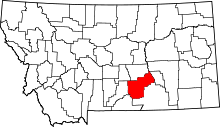
1
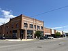
Acme Building
November 9, 2005 (#05001279 ) 109-111 N. Broadway 45°46′59″N 108°30′14″W / 45.7831°N 108.5039°W / 45.7831; -108.5039 (Acme Building ) Billings
2
Upload image January 19, 1983 (#83001078 ) East of Broadview 46°02′38″N 108°43′53″W / 46.0439°N 108.7314°W / 46.0439; -108.7314 (Antelope Stage Station ) Broadview
3
July 7, 2004 (#04000670 ) 1 S. Broadway 45°46′50″N 108°30′12″W / 45.7806°N 108.5033°W / 45.7806; -108.5033 (Armour Cold Storage ) Billings
4
April 9, 2013 (#13000153 ) 114-124 N. 28th & 2808-2812 2nd Aves. 45°46′58″N 108°30′26″W / 45.7827°N 108.5072°W / 45.7827; -108.5072 (Babcock Theater ) Billings
5
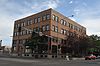
Billings Chamber of Commerce Building
January 20, 1972 (#72000739 ) 303 N. 27th St. 45°47′05″N 108°30′19″W / 45.7847°N 108.5053°W / 45.7847; -108.5053 (Billings Chamber of Commerce Building ) Billings
6
Upload image June 28, 2021 (#100006704 ) 1704 Central Ave. 45°46′04″N 108°33′40″W / 45.7679°N 108.5612°W / 45.7679; -108.5612 (Billings Communal Mausoleum ) Billings
7
March 13, 1979 (#79001427 ) Roughly bounded by N. 23rd and N. 25th Sts. and 1st and Montana Aves.; also 2600 (2528), 2604-2606, 2608, 2610-2614, and 2624 Montana Ave. 45°47′02″N 108°29′59″W / 45.7839°N 108.4997°W / 45.7839; -108.4997 (Billings Historic District ) Billings Second set of addresses represents a boundary increase, the Billings Townsite Historic District, added on April 20, 2006
8
September 16, 2010 (#10000753 ) Generally bounded by Montana Ave. on the north; S. 26th on the east; 1st Ave., S on the south; and S. 30th St. on the west 45°46′50″N 108°30′15″W / 45.7806°N 108.5042°W / 45.7806; -108.5042 (Billings Old Town Historic District ) Billings
9
March 20, 2002 (#02000214 ) 415 Broadwater Ave. 45°46′40″N 108°31′32″W / 45.7778°N 108.5256°W / 45.7778; -108.5256 (Billings West Side School ) Billings
10
January 5, 2007 (#06001224 ) Black Otter Trail 45°48′02″N 108°29′49″W / 45.8006°N 108.4969°W / 45.8006; -108.4969 (Black Otter Trail ) Billings
11
Boothill Cemetery
April 17, 1979 (#79001428 ) North of Billings 45°48′09″N 108°28′48″W / 45.8025°N 108.48°W / 45.8025; -108.48 (Boothill Cemetery ) Billings
12
Dude Rancher Lodge
July 22, 2010 (#10000489 ) 415 N. 29th St. 45°47′05″N 108°30′35″W / 45.7847°N 108.5097°W / 45.7847; -108.5097 (Dude Rancher Lodge ) Billings
13
March 1, 2002 (#02000105 ) 113-115 Broadway 45°47′04″N 108°30′22″W / 45.7844°N 108.5061°W / 45.7844; -108.5061 (Electric Building ) Billings
14
June 9, 2005 (#05000564 ) 110 4th Ave. 45°40′12″N 108°46′32″W / 45.67°N 108.7756°W / 45.67; -108.7756 (Abraham and Carrie Erb House ) Laurel
15
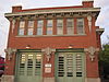
Fire House No. 2
February 29, 1980 (#80002436 ) 201 E. 30th St. 45°46′39″N 108°30′12″W / 45.7775°N 108.5033°W / 45.7775; -108.5033 (Fire House No. 2 ) Billings
16
November 9, 2020 (#100005777 ) 142 Clark Ave. 45°46′48″N 108°31′12″W / 45.7801°N 108.5201°W / 45.7801; -108.5201 (Fratt-Link House ) Billings
17
July 28, 2020 (#100005389 ) 205 North 32nd St. 45°46′52″N 108°30′43″W / 45.7811°N 108.5119°W / 45.7811; -108.5119 (Kate Fratt Memorial Parochial School ) Billings
18
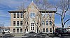
Garfield School
October 3, 2012 (#12000830 ) 3212 1st Ave., S 45°46′35″N 108°30′30″W / 45.7765°N 108.5082°W / 45.7765; -108.5082 (Garfield School ) Billings
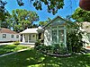
19
April 20, 2015 (#15000160 ) 633 Highland Park Dr. 45°47′49″N 108°31′57″W / 45.797°N 108.5326°W / 45.797; -108.5326 (Arnold Graf House ) Billings
20
Upload image November 20, 1974 (#74001100 ) Address Restricted Billings
21
March 26, 2012 (#12000175 ) Mile 12, , over the Yellowstone River 45°54′14″N 108°19′04″W / 45.9040°N 108.3177°W / 45.9040; -108.3177 (Huntley Bridge ) Huntley
22
June 5, 2017 (#100001033 ) 2291 2nd St., W. 45°57′00″N 108°08′42″W / 45.9501°N 108.1449°W / 45.9501; -108.1449 (Huntley Project Office ) Ballantine
23
L and L Building
October 1, 1979 (#08001227 ) 2624 Minnesota Ave. 45°46′53″N 108°30′07″W / 45.7815°N 108.5019°W / 45.7815; -108.5019 (L and L Building ) Billings
24
September 16, 2010 (#10000768 ) Roughly bounded by the Burlington Northern Santa Fe Railway Company tracks to the south, Third St., S. to the north, Wyoming Ave. 45°40′11″N 108°46′12″W / 45.6697°N 108.77°W / 45.6697; -108.77 (Laurel Downtown Historic District ) Laurel
25
Masonic Temple
April 17, 1986 (#86000847 ) 2806 3rd Ave., N. 45°47′01″N 108°30′25″W / 45.7836°N 108.5069°W / 45.7836; -108.5069 (Masonic Temple ) Billings
26
Upload image March 16, 2021 (#100006311 ) 820 North 31st St. 45°47′12″N 108°30′57″W / 45.7866°N 108.5159°W / 45.7866; -108.5159 (McKinley Elementary School ) Billings
27
September 8, 2015 (#15000574 ) 1500 University Dr. 45°47′48″N 108°31′19″W / 45.7966°N 108.5220°W / 45.7966; -108.5220 (McMullen Hall ) Billings
28
Preston B. Moss House
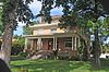
April 30, 1982 (#82003181 ) 914 Division St.[5] 45°46′46″N 108°30′55″W / 45.7794°N 108.5153°W / 45.7794; -108.5153 (Preston B. Moss House ) Billings
29
March 26, 2012 (#12000174 ) Mile 57 on an Interstate 90 frontage road 45°40′57″N 108°42′50″W / 45.6826°N 108.7139°W / 45.6826; -108.7139 (Mossman Overpass ) Laurel Over railroad tracks.
30
Austin North House
November 23, 1977 (#77000822 ) 622 N. 29th St. 45°47′11″N 108°30′41″W / 45.7864°N 108.5114°W / 45.7864; -108.5114 (Austin North House ) Billings
31
November 29, 2016 (#16000807 ) Bounded by 12th Ave. N, alley between N 31st & 30th Sts., 9th Ave. N & 32ns St. N 45°47′23″N 108°31′08″W / 45.7897°N 108.5190°W / 45.7897; -108.5190 (North Elevation Historic District ) Billings
32
Northern Hotel
June 12, 2013 (#13000369 ) 19 N. Broadway 45°46′55″N 108°30′20″W / 45.7820°N 108.5055°W / 45.7820; -108.5055 (Northern Hotel ) Billings
33
November 23, 1977 (#77000823 ) 105 Clark Ave. 45°46′49″N 108°31′02″W / 45.7803°N 108.5172°W / 45.7803; -108.5172 (I.D. O'Donnell House ) Billings
34
Oliver Building
October 1, 1979 (#08001228 ) 2702 Montana Ave. 45°46′54″N 108°30′14″W / 45.7818°N 108.5038°W / 45.7818; -108.5038 (Oliver Building ) Billings
35
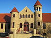
Parmly Billings Memorial Library
October 26, 1972 (#72000740 ) 2822 Montana Ave. 45°46′50″N 108°30′21″W / 45.7806°N 108.5057°W / 45.7806; -108.5057 (Parmly Billings Memorial Library ) Billings
36
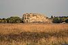
Pictograph Cave
October 15, 1966 (#66000439 ) 7 miles (11 km) southeast of Billings in Indian Caves Park 45°44′12″N 108°25′56″W / 45.7367°N 108.4322°W / 45.7367; -108.4322 (Pictograph Cave ) Billings
37
Upload image April 13, 2021 (#100006391 ) Roughly bounded by Parkhill Dr., 3rd St. West, and Virginia Ln. 45°47′16″N 108°31′30″W / 45.7879°N 108.5251°W / 45.7879; -108.5251 (Pioneer Park ) Billings
38
Pompey's Pillar
October 15, 1966 (#66000440 ) West of Pompey 45°59′44″N 108°00′17″W / 45.9956°N 108.0047°W / 45.9956; -108.0047 (Pompey's Pillar ) Pompey's Pillar
39
Prescott Commons
April 30, 1982 (#82003182 ) Rimrock Rd. 45°47′52″N 108°33′08″W / 45.7978°N 108.5522°W / 45.7978; -108.5522 (Prescott Commons ) Billings
40
Upload image June 21, 2007 (#07000578 ) 111 Emerald Dr. 45°48′21″N 108°28′56″W / 45.8058°N 108.4822°W / 45.8058; -108.4822 (Harold and Marion Ruth House ) Billings
41
U.S. Post Office and Courthouse-Billings
March 14, 1986 (#86000678 ) 2602 1st Ave., N. 45°46′58″N 108°30′10″W / 45.7828°N 108.5028°W / 45.7828; -108.5028 (U.S. Post Office and Courthouse-Billings ) Billings
42
October 1, 1979 (#79003779 ) 208 S. 35th St. 45°46′26″N 108°30′36″W / 45.7739°N 108.51°W / 45.7739; -108.51 (Christian Yegen House ) Billings
43
April 16, 1980 (#80002437 ) 209 S. 35th St. 45°46′27″N 108°30′35″W / 45.7742°N 108.5097°W / 45.7742; -108.5097 (Peter Yegen House ) Billings