Location of Chouteau County in Montana
This is a list of the National Register of Historic Places listings in Chouteau County, Montana . It is intended to be a complete list of the properties and districts on the National Register of Historic Places in Chouteau County , Montana , United States . The locations of National Register properties and districts for which the latitude and longitude coordinates are included below, may be seen in a map.[1]
There are 21 properties and districts listed on the National Register in the county, including 1 National Historic Landmark .
This National Park Service list is complete through NPS recent listings posted February 11, 2022. [2]
Listings county-wide [ ]
[3] Name on the Register
Image
Date listed[4]
Location
City or town
Description
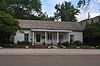
1
November 20, 1980 (#80002403 ) 1604 Front St. 47°49′08″N 110°39′35″W / 47.818889°N 110.659722°W / 47.818889; -110.659722 (I.G. Baker House ) Fort Benton
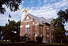
2
Chouteau County Courthouse
September 29, 1980 (#80002404 ) 1308 Franklin St. 47°49′03″N 110°39′53″W / 47.8175°N 110.664722°W / 47.8175; -110.664722 (Chouteau County Courthouse ) Fort Benton
3
November 13, 1974 (#74001095 ) East of Fort Benton 47°49′52″N 110°04′28″W / 47.831111°N 110.074444°W / 47.831111; -110.074444 (Citadel Rock ) Fort Benton
4
Upload image January 28, 2009 (#08001383 ) Eagle Butte School Rd., 23 miles off Montana Highway 80 47°53′09″N 110°10′12″W / 47.885712°N 110.169923°W / 47.885712; -110.169923 (Eagle Butte School ) Fort Benton
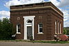
5
January 9, 2008 (#07001363 ) 311 Main St. 47°36′09″N 110°15′53″W / 47.6025°N 110.264722°W / 47.6025; -110.264722 (First National Bank of Geraldine ) Geraldine
6
Fort Benton
October 15, 1966 (#66000431 ) Front St. (1220 through 1900 block) levee, and bridge 47°49′04″N 110°40′02″W / 47.817778°N 110.667222°W / 47.817778; -110.667222 (Fort Benton ) Fort Benton
7
Fort Benton Bridge
August 6, 1980 (#80002406 ) Spans the Missouri River 47°49′02″N 110°39′38″W / 47.817222°N 110.660556°W / 47.817222; -110.660556 (Fort Benton Bridge ) Fort Benton
8
Fort Benton Engine House
November 20, 1980 (#80002407 ) Front and 15th Sts. 47°49′02″N 110°39′38″W / 47.817222°N 110.660556°W / 47.817222; -110.660556 (Fort Benton Engine House ) Fort Benton
9
Geraldine Milwaukee Depot
March 21, 1997 (#97000254 ) Railroad Ave., approximately 10 miles south of Montana Highway 80 47°36′14″N 110°15′55″W / 47.603889°N 110.265278°W / 47.603889; -110.265278 (Geraldine Milwaukee Depot ) Geraldine
10
Grand Union Hotel
January 2, 1976 (#76001121 ) 14th and Front Sts. 47°48′52″N 110°40′08″W / 47.814444°N 110.668889°W / 47.814444; -110.668889 (Grand Union Hotel ) Fort Benton
11
Judith Landing Historic District
December 6, 1975 (#75001081 ) Upper Missouri River Breaks National Monument 47°44′14″N 109°37′34″W / 47.737361°N 109.626104°W / 47.737361; -109.626104 (Judith Landing Historic District ) Winifred Historic site managed by BLM; extends into Fergus County . Boundary increase on 2014-04-11.
12
Upload image December 16, 1974 (#74001094 ) 40 miles south of the Big Sandy River on the Missouri River 47°43′04″N 109°50′59″W / 47.717778°N 109.849722°W / 47.717778; -109.849722 (Lewis and Clark Camp at Slaughter River ) Big Sandy
13
Lonetree Upload image September 11, 1980 (#80002410 ) South of Geraldine 47°32′37″N 110°17′21″W / 47.543611°N 110.289167°W / 47.543611; -110.289167 (Lonetree ) Geraldine
14
Masonic Building
October 14, 1980 (#80002408 ) 1418 Front St. 47°49′03″N 110°39′41″W / 47.8175°N 110.661389°W / 47.8175; -110.661389 (Masonic Building ) Fort Benton
15
September 29, 1980 (#80002409 ) 14th and Chouteau Sts. 47°49′06″N 110°39′58″W / 47.818333°N 110.666111°W / 47.818333; -110.666111 (St. Paul's Episcopal Church ) Fort Benton
16
Upload image March 26, 2012 (#12000169 ) Approximately mile 21 on Shonkin Rd. 47°33′57″N 110°33′11″W / 47.565697°N 110.552999°W / 47.565697; -110.552999 (Shonkin Creek Bridge ) Geraldine vicinitypart of the Montana's Steel Stringer and Steel Girder Bridges MPS
17
Upload image July 23, 1998 (#98000888 ) Salsbury Ave. 47°31′02″N 110°11′52″W / 47.517222°N 110.197778°W / 47.517222; -110.197778 (Square Butte Jail ) Square Butte
18
Upload image July 15, 2013 (#13000496 ) Northwest corner of Diederick St. and Broadway 47°31′00″N 110°12′08″W / 47.516567°N 110.202230°W / 47.516567; -110.202230 (Square Butte School ) Square Butte
19
Upload image April 15, 1993 (#93000275 ) Address Restricted Carter
20
April 15, 1997 (#97000315 ) County Road 430, approximately 6.3 miles south of U.S. Route 87 48°00′57″N 110°14′55″W / 48.015833°N 110.248611°W / 48.015833; -110.248611 (Virgelle Mercantile and Virgelle State Bank )
21
Upload image March 3, 2000 (#00000163 ) Flat Creek Rd. 47°32′42″N 110°16′58″W / 47.545°N 110.282778°W / 47.545; -110.282778 (West Quincy Granite Quarry ) Square Butte
Former listings [ ]
[3] Name on the Register
Image
Date listed Date removed Location
City or town
Description
1
Upload image August 11, 1980 (#80002405) June 3, 1986 Washington and Fourteenth Sts. Fort Benton
See also [ ] References [ ]
^ The latitude and longitude information provided in this table was derived originally from the National Register Information System, which has been found to be fairly accurate for about 99% of listings. Some locations in this table may have been corrected to current GPS standards.
^ National Park Service, United States Department of the Interior , "National Register of Historic Places: Weekly List Actions" , retrieved February 11, 2022.
^ a b Numbers represent an alphabetical ordering by significant words. Various colorings, defined here , differentiate National Historic Landmarks and historic districts from other NRHP buildings, structures, sites or objects.
^ The eight-digit number below each date is the number assigned to each location in the National Register Information System database, which can be viewed by clicking the number.