National Register of Historic Places listings in Sioux County, Nebraska

Location of Sioux County in Nebraska
This is a list of the National Register of Historic Places listings in Sioux County, Nebraska. It is intended to be a complete list of the properties and districts on the National Register of Historic Places in Sioux County, Nebraska, United States. The locations of National Register properties and districts for which the latitude and longitude coordinates are included below, may be seen in an online map.
There are 7 properties and districts listed on the National Register in the county.
- This National Park Service list is complete through NPS recent listings posted February 11, 2022.[1]
Current listings[]
| [2] | Name on the Register[3] | Image | Date listed[4] | Location | City or town | Description |
|---|---|---|---|---|---|---|
| 1 | Agate Fossil Beds National Monument | 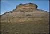 |
October 30, 2013 (#12001126) |
4641 Highway 29[5] 42°25′15″N 103°47′38″W / 42.420954°N 103.793857°W | Harrison | Previously the Agate Springs Ranch[3] |
| 2 | Harold J. Cook Homestead Cabin |  |
August 24, 1977 (#77000156) |
3 miles east of Agate off Nebraska Highway 29 on the Agate Fossil Beds National Monument 42°25′05″N 103°44′21″W / 42.41815°N 103.73918°W | Agate | Also known as Bone Cabin.[6] |
| 3 | Fort Robinson and Red Cloud Agency |  |
October 15, 1966 (#66000442) |
2 miles west of Crawford 42°40′02″N 103°27′13″W / 42.667222°N 103.453611°W | Crawford | Extends into Dawes County |
| 4 | Hudson-Meng Bison Kill Site |  |
August 28, 1973 (#73001076) |
Sand Creek Rd., northwest of Crawford[7] 42°49′43″N 103°36′06″W / 42.828611°N 103.601667°W | Crawford | |
| 5 | Sandford Dugout | March 9, 2000 (#00000166) |
25 miles (40 km) north of Mitchell and 2 miles (3.2 km) west of Nebraska Highway 29[8] | Mitchell | ||
| 6 | Sioux County Courthouse | July 5, 1990 (#90000963) |
Northeastern corner of Main and 3rd Sts. 42°41′20″N 103°53′00″W / 42.68895°N 103.88340°W | Harrison | ||
| 7 | Wind Springs Ranch Historic and Archeological District | November 22, 2000 (#00001403) |
Wind Springs Creek Valley 42°04′33″N 103°39′53″W / 42.075833°N 103.664722°W | Scottsbluff |

See also[]
- List of National Historic Landmarks in Nebraska
- National Register of Historic Places listings in Nebraska
References[]
- ^ National Park Service, United States Department of the Interior, "National Register of Historic Places: Weekly List Actions", retrieved February 11, 2022.
- ^ Numbers represent an alphabetical ordering by significant words. Various colorings, defined here, differentiate National Historic Landmarks and historic districts from other NRHP buildings, structures, sites or objects.
- ^ a b "National Register Information System". National Register of Historic Places. National Park Service. March 13, 2009.
- ^ The eight-digit number below each date is the number assigned to each location in the National Register Information System database, which can be viewed by clicking the number.
- ^ "Contact Us". Agate Springs Ranch. Retrieved November 23, 2013.
- ^ "Outdoor Activities". Agate Fossil Beds National Monument. Retrieved 2012-08-27.
- ^ Motor Vehicle Use Map: Oglala National Grassland, United States Forest Service, 2010. Accessed 2013-06-02.
- ^ Knispel, Todd H. (December 10, 1999). "National Register of Historic Places Registration Form: Sandford Dugout" (PDF). National Park Service. Archived from the original on July 16, 2012. Retrieved October 20, 2013.
{{cite web}}: CS1 maint: unfit URL (link)
External links[]
| Wikimedia Commons has media related to National Register of Historic Places in Sioux County, Nebraska. |
| National Historic Landmark | ||
|---|---|---|
| Historic districts | ||
| Historic properties | ||
| Footnotes | ‡This historic property also has portions in an adjacent county. | |
| Topics |  | |
|---|---|---|
| Lists by county |
| |
| Other lists |
| |
| ||
Municipalities and communities of Sioux County, Nebraska, United States | ||
|---|---|---|
| Village | ||
| Unincorporated communities | ||
| ||
Categories:
- Sioux County, Nebraska
- Lists of National Register of Historic Places in Nebraska by county
- National Register of Historic Places in Sioux County, Nebraska