National Register of Historic Places listings in southern Puerto Rico

This is a list of properties and districts in the southern municipalities of Puerto Rico that are listed on the National Register of Historic Places (Spanish: Registro Nacional de Lugares Históricos). It includes places along the southern coast of the island, and on the south slope of Puerto Rico's Cordillera Central.
The area covered spans from the city of Yauco on the southwest coast to the Guayama municipality at the southeast.
Names of places given are as they appear in the National Register, reflecting name as given in NRHP application at the date of listing. Note, the National Register name system does not accommodate Spanish á, ñ and other letters.
See also:
- National Register of Historic Places listings in Puerto Rico
- National Register of Historic Places listings in northern Puerto Rico
- National Register of Historic Places listings in western Puerto Rico
- National Register of Historic Places listings in central Puerto Rico
- National Register of Historic Places listings in eastern Puerto Rico
- National Register of Historic Places listings in San Juan, Puerto Rico
This National Park Service list is complete through NPS recent listings posted March 11, 2022.[1]
Guayama[]
| [2] | Name on the Register | Image | Date listed[3] | Location | Barrio | Description |
|---|---|---|---|---|---|---|
| 1 | October 30, 2020 (#100005741) |
PR-15, from km. 0 in Guayama to km. 25.7 in Cayey 18°03′01″N 66°08′07″W / 18.0502°N 66.1352°W | Guayama to Cayey | |||
| 2 | Casa Cautiño |  |
December 31, 1984 (#84003137) |
1 N. Santiago Palmer Street[4] 17°59′09″N 66°06′48″W / 17.9859°N 66.1132°W | Guayama Pueblo | Built in 1887, this house is one of the best remaining examples of southern Puerto Rico's 19th-century vernacular style of urban domestic architecture, blended with extensive Neoclassical elements. Especially notable is the house's masonry, wood, and metal ornamentation. It was acquired for use as a museum in 1979.[5][4] |
| 3 | Cayey Bridge | 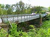 |
July 19, 1995 (#95000845) |
Highway 15, km 1, spanning Río Guamaní 17°59′59″N 66°06′46″W / 17.9997°N 66.1128°W | Caimital and Palmas | This 1891 iron bridge carries the nineteenth century highway between Guayama and Cayey, which was once the only link between the coastal east of Puerto Rico and the rest of the island. Its lateral lattice girder design is characteristic of Puerto Rico but rare in the United States.[6] |
| 4 | Eleuterio Derkes Grammar School | 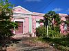 |
August 4, 1987 (#87001312) |
José María Anguelí Street 17°58′55″N 66°06′42″W / 17.9819°N 66.1118°W | Guayama Pueblo | Built in 1908, this school was designed during a period when schools were gaining importance as civic institutions in Puerto Rico. Its simplified Neoclassical design emphasized this shift, and it became a prototype for a generation of school construction on the island.[7] |
| 5 | Iglesia Parroquial de San Antonio de Padua de Guayama | 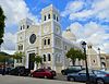 |
July 30, 1976 (#76002248) |
5 Ashford Street 17°59′07″N 66°06′46″W / 17.9852°N 66.1129°W | Guayama Pueblo | This church was first built in the 18th century and rebuilt twice in the 19th century and its present appearance dates from 1874. It takes an overall Romanesque form, while the details exhibit the eclecticism that characterized much Puerto Rican architecture in the later 1800s.[8] |
| 6 | Ingenio Azucarero Vives | 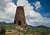 |
September 1, 1976 (#76002249) |
Avenida Central 17°58′38″N 66°06′59″W / 17.9771°N 66.1164°W | Guayama Pueblo | The Vives Sugar Mill, built c. 1828, comprises the remains of a windmill and processing building. Constructed of river rock, cut granite, and some brick, it contrasts with later industrial buildings built primarily of brick. The mill recalls an era when the sugar industry used slave labor almost exclusively, and witnessed a slave uprising in the first half of the 19th century.[9][10] |
Guayanilla[]
| [2] | Name on the Register | Image | Date listed[3] | Location | Barrio | Description |
|---|---|---|---|---|---|---|
| 1 | Padre Nazario School |  |
November 14, 2012 (#12000936) |
4 Concepción Street 18°01′08″N 66°47′25″W / 18.018757°N 66.790308°W | Guayanilla Pueblo | Completed in 1926, this primary school epitomizes the monumental schools built in Puerto Rico during the early 20th century. Its Neoclassical and Spanish Revival details at the entry and spatial sequence of the vestibule are exceptional design features.[11] |
Juana Díaz[]
| [2] | Name on the Register | Image | Date listed[3] | Location | Barrio | Description |
|---|---|---|---|---|---|---|
| 1 | Carretera Central | May 2, 2019 (#100003686) |
Highway 14 from Coamo boundary to Ponce boundary[a] 18°03′04″N 66°28′45″W / 18.050999°N 66.479179°W | Río Cañas Arriba, Río Cañas Abajo, Tijeras, Juana Díaz Pueblo, Jacaguas, and Callabo | Built by the Spanish administration during 1846–1886 to connect San Juan with Ponce, this was one of the first modern roadways in Puerto Rico and was regarded as one of the finest roads in the Americas for years after its completion. The listed portion of the road, from Caguas to Juana Díaz, includes the exceptionally challenging engineering through the Cordillera Central, 11 major bridges, 14 maintenance workers' houses,[b] and numerous other roadway structures.[12][13] | |
| 2 | Church San Juan Bautista y San Ramón Nonato of Juana Diaz[c] | 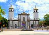 |
December 10, 1984 (#84000465) |
Town Plaza 18°03′10″N 66°30′19″W / 18.052897°N 66.505350°W | Juana Díaz Pueblo | This Baroque church built in 1807[d] retains most of its original design, construction, and materials, including masonry walls, towers, sacristies, interior arcades, dome, and wooden spiral stairway in the south tower. The church's placement in the town plaza and close to the town hall reflect the Crown-mandated urban design principles of the early 19th century.[14][16] |
| 3 | Cueva Lucero |  |
September 26, 2008 (#08000936) |
Address restricted[e][17] | Guayabal | This cave includes more than 100 pre-Hispanic petroglyphs and pictographs dating possibly as early as the 7th century C.E., "making it one of the best examples of aboriginal rock art in the Antilles." Most of the images are zoomorphic in nature. It has been known to archaeologists since at least the early 1900s.[18] |
Peñuelas[]
| [2] | Name on the Register | Image | Date listed[3] | Location | Barrio | Description |
|---|---|---|---|---|---|---|
| 1 | Daniel Webster School |  |
November 14, 2012 (#12000940) |
255 Luis Muñoz Rivera Street 18°03′16″N 66°43′20″W / 18.054495°N 66.722086°W | Peñuelas Pueblo | Designer Francisco Gardón Vega[f] employed a mixture of Beaux-Arts and Spanish Revival styles in this 1927 school, a common stylistic approach in Puerto Rico at the time. The school quickly became a centerpiece of public architecture in Peñuelas, surpassing the church and city hall, and remains important to local public identity.[19] |
Ponce[]
| [2] | Name on the Register | Image | Date listed[3] | Location | Barrio | Description |
|---|---|---|---|---|---|---|
| 1 | Acueducto Alfonso XII |  |
December 30, 2019 (#100004854) |
Calle del Acueducto 18°01′17″N 66°36′51″W / 18.021358°N 66.614251°W | Portugués Urbano and Sexto | This aqueduct, completed in 1878 and in service until 1928, was the key component of Ponce's first system for distribution of potable water. It exemplifies 19th century design principles, and recalls civic investments to promote the welfare of urban inhabitants. Of the aqueduct's total length of 4 kilometers (2.5 mi), about 400 meters (1,300 ft) are included in the historic listing.[20] |
| 2 | Albergue Caritativo Tricoche |  |
May 14, 1987 (#87000769) |
Tricoche Street 18°01′00″N 66°36′55″W / 18.016785°N 66.615193°W | Segundo | Hospital in Neoclásico Isabelino style from 1885 |
| 3 | Antiguo Cuartel Militar Español de Ponce |  |
May 14, 1987 (#87000772) |
End of Castillo Street 18°00′55″N 66°36′30″W / 18.015201°N 66.608439°W | Quinto | Spanish military headquarters in Ponce, in Neoclásico Isabelino style, from 1894 |
| 4 | Antiguo Hospital Militar Español de Ponce |  |
May 14, 1987 (#87000770) |
León, Atocha, and Bondad Streets 18°01′08″N 66°36′52″W / 18.019026°N 66.614432°W | Sexto | Neoclásico Isabelino style, from 1897 |
| 5 | Armstrong-Toro House |  |
October 29, 1987 (#87001821) |
9 Unión Street 18°00′42″N 66°36′53″W / 18.011728°N 66.614622°W | Segundo | Neoclassical designed by Manuel Domenech and built in 1899 |
| 6 | Banco Crédito y Ahorro Ponceño | 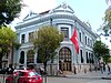 |
June 25, 1987 (#87001002) |
Junction of Marina and Amor Streets 18°00′41″N 66°36′48″W / 18.011314°N 66.613333°W | Tercero | Beaux Arts design by Francisco Porrata Doria, from 1924 |
| 7 | Banco de Ponce |  |
June 25, 1987 (#87001003) |
Junction of Amor and Comercio Streets 18°00′40″N 66°36′48″W / 18.011111°N 66.613271°W | Tercero | Beaux Arts design by Francisco Porrata Doria, also from 1924 |
| 8 | September 14, 2021 (#100006919) |
Road #6 Coordinates missing | Ponce vicinity | |||
| 9 | Casa Alcaldía de Ponce – City Hall |  |
November 19, 1986 (#86003197) |
South side of Plaza Las Delicias 18°00′39″N 66°36′50″W / 18.010730°N 66.613905°W | Primero | Neoclásico Isabelino-style City Hall, from 1846 |
| 10 | Casa de la Masacre |  |
October 20, 2005 (#05001098) |
31 Marina Street 18°00′34″N 66°36′49″W / 18.009318°N 66.613537°W | Cuarto | As the Ponce headquarters of the Puerto Rican Nationalist Party during the 1930s, this house bore witness to the massacre of March 21, 1937, in which 19 demonstrators and bystanders and 2 police officers were killed. It is architecturally significant as an outstanding example of vernacular creole design by Blas Silva from the first decade of the 20th century. It became a museum in 1988.[21] |
| 11 | [g] |  |
April 30, 1986 (#86000894) |
146 Reina Street 18°00′43″N 66°37′08″W / 18.012054°N 66.618850°W | Segundo | House from 1919, designed by [22] |
| 12 | Casa Paoli |  |
October 1, 2009 (#09000769) |
14 Mayor Street 18°00′36″N 66°36′46″W / 18.009928°N 66.612659°W | Cuarto | This house was the birthplace and childhood home of great operatic tenor Antonio Paoli (1871–1946) until 1883. It was in Ponce's rich cultural environment that Paoli was first exposed to the arts, and this house is the only property remaining in Puerto Rico associated with the island's first performing artist of international renown.[25] |
| 13 | Casa Vives |  |
February 13, 2013 (#13000013) |
88 Paseo Atocha at Vives/Castillo Street 18°00′51″N 66°36′49″W / 18.014097°N 66.613524°W | Quinto | |
| 14 | Casino de Ponce |  |
October 28, 1987 (#87001818) |
Junction of Marina and Luna Streets 18°00′36″N 66°36′48″W / 18.010082°N 66.613368°W | Cuarto | Second Empire- and Neo-Rococo-style building from 1922, designed by |
| 15 | Castillo de Serralles[h] |  |
November 3, 1980 (#80004494) |
Cerro El Vigía 18°01′07″N 66°37′09″W / 18.018698°N 66.619274°W | Portugués Urbano | Spanish Mediterranean style "castle" from 1926 by Pedro Adolfo de Castro[26] |
| 16 | Cathedral Nuestra Señora de Guadalupe of Ponce | 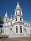 |
December 10, 1984 (#84000467) |
Plaza Las Delicias 18°00′43″N 66°36′50″W / 18.011839°N 66.613992°W | Segundo | Neoclassical building from 1835 by Francisco Porrata Doria |
| 17 | Cementerio Antiguo de Ponce |  |
January 5, 1984 (#84003149) |
1 Torre Street at Frontispicio Street 18°00′57″N 66°37′04″W / 18.015833°N 66.617778°W | Segundo | Neo-classical. 1864 enlargement designed by , from 1842 |
| 18 | Cementerio Catolico San Vicente de Paul[i] |  |
August 25, 1988 (#88001249) |
Alma Sublime Street 18°01′00″N 66°38′02″W / 18.016596°N 66.633782°W | Magueyes Urbano | Classical Revival, Spanish Revival, Art Deco from 1901, also called Cementerio Católico de Ponce[28] |
| 19 | Centro Ceremonial Indígena |  |
April 14, 1978 (#78003381) |
Highway 503 18°02′32″N 66°37′18″W / 18.042236°N 66.621781°W | Tibes and Portugués | Also known as Batey Indígena de Tibes. (Also, Tibes Indigenous Ceremonial Center) |
| 20 |  |
August 27, 2013 (#13000638) |
834 Eugenio María de Hostos Avenue 17°58′55″N 66°37′12″W / 17.981903°N 66.620132°W | Playa | ||
| 21 |  |
August 27, 2013 (#13000639) |
28 Alfonso XII Street at Padre Noel Avenue 17°58′55″N 66°37′16″W / 17.981943°N 66.621142°W | Playa | ||
| 22 | Faro de la Isla de Caja de Muertos |  |
October 22, 1981 (#81000690) |
Isla Caja de Muertos 17°53′35″N 66°31′16″W / 17.893159°N 66.521189°W | Playa | Neo-classical light house from 1887 |
| 23 | Faro del Puerto de Ponce |  |
October 22, 1981 (#81000691) |
Isla Cardona, Ponce Harbor 17°57′24″N 66°38′06″W / 17.956800°N 66.635000°W | Playa | Neo-classical light house from 1889 |
| 24 | Font–Ubides House |  |
October 29, 1987 (#87001825) |
34 Castillo Street 18°00′54″N 66°36′39″W / 18.014913°N 66.610786°W | Quinto | Classical Revival, Art Nouveau building by Blas C. Silva, from 1913 |
| 25 | Hacienda Buena Vista |  |
October 17, 1994 (#91001499) |
Highway123, km 16.8, near Corral Viejo 18°05′03″N 66°39′17″W / 18.084104°N 66.654591°W | Magueyes | Colonial-style coffee plantation from 1833 |
| 26 | Iglesia de la Santísima Trinidad |  |
September 29, 1986 (#86002766) |
Marina, Salud, and Abolición Streets 18°00′25″N 66°36′46″W / 18.007006°N 66.612770°W | Cuarto | Late Gothic Revival, Mission/Spanish Revival church from 1926 |
| 27 | McCabe Memorial Church |  |
April 11, 2008 (#08000283) |
835 Eugenio María de Hostos Avenue 17°58′56″N 66°37′14″W / 17.982187°N 66.620440°W | Playa | Neo-gothic church from 1908 designed by Antonin Nechodoma |
| 28 | Mercado de las Carnes |  |
November 17, 1986 (#86003199) |
Alley connecting Mayor and León Streets, between Estrella and Guadalupe Streets 18°00′56″N 66°36′46″W / 18.015477°N 66.612878°W | Quinto | Art Deco meat market from 1926 by Rafael Carmoega |
| 29 | Missionary Society of the Methodist Episcopal Church | 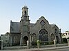 |
October 29, 1987 (#87001822) |
135 Villa Street 18°00′37″N 66°36′58″W / 18.010405°N 66.616094°W | Primero | Bungalow, integrating Neo-Gothic, Spanish Revival, Spanish Baroque, and byzantine elements, from 1907, designed by Antonin Nechodoma |
| 30 | Oppenheimer House |  |
October 29, 1987 (#87001824) |
47 Salud Street 18°00′34″N 66°36′43″W / 18.009418°N 66.611890°W | Cuarto | Spanish-Art Nouveau house from 1913, designed by Alfredo B. Weichers |
| 31 | Parque de Bombas de Ponce | 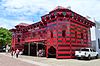 |
July 12, 1984 (#84003150) |
Plaza Las Delicias 18°00′43″N 66°36′49″W / 18.011905°N 66.613738°W | Segundo | Fire station in Gothic style, from 1882 by Maximo de Meana y Guridi. |
| 32 | Teatro La Perla |  |
September 27, 2021 (#100007054) |
Calle Mayor Esq. Cristina 18°00′44″N 66°36′43″W / 18.0122°N 66.6119°W | Tercero | |
| 32 | Ponce High School |  |
August 4, 1987 (#87001310) |
Cristina Street 18°00′42″N 66°36′37″W / 18.011550°N 66.610260°W | Tercero | Classical Revival building from 1915, designed by |
| 33 | Ponce YMCA Building |  |
June 4, 2012 (#12000331) |
7843 Nazaret Street, Urbanización Santa María 18°00′21″N 66°37′02″W / 18.005888°N 66.617149°W | Canas Urbano | Part of the Rafael Rios Rey Multiple Property Submission |
| 34 | Puente Río Portugués |  |
January 6, 2015 (#14001134) |
Eugenio María de Hostos Avenue, spanning the historic channel of Río Portugués 17°59′36″N 66°36′55″W / 17.993399°N 66.615293°W | Playa | |
| 35 | Rosaly–Batiz House |  |
September 29, 1986 (#86002768) |
125 Villa Street 18°00′39″N 66°36′55″W / 18.01072°N 66.61522°W | Primero | Italian Renaissance Palazzo house by Manuel V. Domenech from 1897 |
| 36 | Salazar–Candal House |  |
June 9, 1988 (#88000663) |
53 Isabel Street 18°00′45″N 66°36′42″W / 18.012546°N 66.611729°W | Tercero | Neo-Classic, Art Nouveau, and Spanish Revival house from 1911, designed by Blas C. Silva |
| 37 | Subirá House | 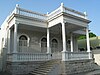 |
October 28, 1987 (#87001826) |
107 Reina Street 18°00′43″N 66°36′58″W / 18.012038°N 66.616116°W | Segundo | Ponce Creole house from 1910, designed by Blas C. Silva |
| 38 | Fernando Luis Toro Casa[j] | 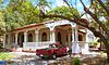 |
March 5, 1986 (#86000421) |
3 Obispado Street, La Alhambra 18°01′04″N 66°36′21″W / 18.017812°N 66.605786°W | Machuelo Abajo | Victorian, Georgian, Neo-classic, Beaux Arts, Spanish Revival and Catalan Modernism from 1927, designed by Francisco Porrata Doria |
| 39 | U.S. Custom House |  |
February 10, 1988 (#88000073) |
Junction of Bonaire and Aduana Streets 17°58′47″N 66°37′12″W / 17.979817°N 66.619953°W | Playa | Spanish colonial, possibly by from 1842 |
| 40 | Villaronga House | 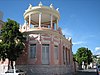 |
August 24, 1984 (#84003151) |
106 Reina Street 18°00′44″N 66°36′57″W / 18.012310°N 66.615850°W | Segundo | Classical Revival house from 1921, designed by Alfredo B. Wiechers |
| 41 | Zaldo de Nebot Residencia[k] | 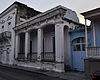 |
June 9, 1988 (#88000643) |
27 Marina Street 18°00′35″N 66°36′49″W / 18.009685°N 66.613687°W | Primero | Built to a Neoclassical design in 1895, this house is one of the fullest expressions of 19th century architecture for Ponce's wealthy creole class. Notable are the trompe-l'œil interior wall paintings of Parisian landmarks and fin de siècle decorative detailing.[35] |
Salinas[]
| [2] | Name on the Register | Image | Date listed[3] | Location | Barrio | Description |
|---|---|---|---|---|---|---|
| 1 | Central Aguirre Historic District |  |
October 23, 2002 (#02001208) |
Highway 705, south from Highway 3, km 151.3 17°57′20″N 66°13′29″W / 17.955628°N 66.224612°W | Aguirre | From 1899 |
Santa Isabel[]
| [2] | Name on the Register | Image | Date listed[3] | Location | Barrio | Description |
|---|---|---|---|---|---|---|
| 1 | 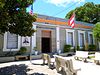 |
February 4, 2011 (#10001217) |
33 Eugenio M. de Hostos Street 17°58′04″N 66°24′15″W / 17.967723°N 66.404196°W | Santa Isabel Pueblo | ||
| 2 | December 13, 2016 (#16000853) |
Linear district roughly parallel to Highway 153, between Highway 52 to the north and Highway 1 to the south 17°58′47″N 66°23′23″W / 17.979684°N 66.389632°W | Boca Velázquez, Jauca II, Felicia II, Felicia I, Santa Isabel Pueblo |
Yauco[]
| [2] | Name on the Register | Image | Date listed[3] | Location | Barrio | Description |
|---|---|---|---|---|---|---|
| 1 | Casa Agostini |  |
June 9, 1988 (#88000682) |
Dr. Gatell Street, between Santiago Vivaldi and Comercio Streets 18°02′04″N 66°50′53″W / 18.034566°N 66.847933°W | Yauco Pueblo | A Classical Revival house designed by |
| 2 | Casa Franceschi Antongiorgi |  |
January 16, 1985 (#85000113) |
Junction of 25th of July Street and Barbosa Street 18°02′01″N 66°50′55″W / 18.033505°N 66.848713°W | Yauco Pueblo | A Beaux Arts house from 1907 |
| 3 | 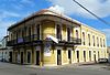 |
January 16, 1985 (#85000114) |
25th of July Street 18°02′00″N 66°51′05″W / 18.033277°N 66.851263°W | Yauco Pueblo | House from 1893 | |
| 4 | Chalet Amill |  |
January 16, 1985 (#85000115) |
33 Mattei Lluveras Street 18°02′08″N 66°51′00″W / 18.035620°N 66.850109°W | Yauco Pueblo | |
| 5 | Filardi House | 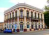 |
January 16, 1985 (#85000116) |
Junction of 25th of July Street and Baldorioty Street 18°02′00″N 66°51′00″W / 18.033258°N 66.849906°W | Yauco Pueblo | This 1916 house is notable for its extensive use of concrete sculptural ornamentation. Juan Bautista and Domingo Filardi integrated the outstanding decorative features with the overall Beaux-Arts plan,[l] and later came to be recognized as experts in cast concrete ornamental elements.[36] |
| 6 | Logia Masónica Hijos de la Luz |  |
June 9, 1988 (#88000684) |
José Celso Barbosa Avenue 18°01′55″N 66°50′54″W / 18.031929°N 66.848455°W | Yauco Pueblo | From 1894 |
| 7 | October 14, 2021 (#100007078) |
64 Comercio St. 18°02′05″N 66°51′13″W / 18.0346°N 66.8536°W | Yauco Pueblo | |||
| 8 |  |
February 5, 1987 (#86003201) |
26 Mattei Lluveras Street 18°02′09″N 66°50′53″W / 18.035823°N 66.847939°W | Yauco Pueblo | Criollo style house from 1880 | |
| 9 | 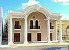 |
June 9, 1988 (#88000683) |
Comercio Street 18°02′05″N 66°50′54″W / 18.034752°N 66.848372°W | Yauco Pueblo |
See also[]
- National Register of Historic Places listings in Puerto Rico
- National Register of Historic Places listings in northern Puerto Rico
- National Register of Historic Places listings in western Puerto Rico
- National Register of Historic Places listings in central Puerto Rico
- National Register of Historic Places listings in eastern Puerto Rico
- National Register of Historic Places listings in San Juan, Puerto Rico
- Historic preservation
- History of Puerto Rico
Notes[]
- ^ The listed portion of the Carretera Central extends into Caguas, Cidra, Cayey, Aibonito, Coamo, and Juana Díaz. The roadway route in San Juan and Ponce, as well as a portion in Caguas, was excluded from the National Register listing.
- ^ Spanish: casillas de caminero.
- ^ The name of Church San Juan Bautista y San Ramón Nonato of Juana Diaz is presented here without the accent on "Díaz" in conformance with the usage in the house's National Register nomination form[14] and announcement of listing.[15] The latter source additionally omits the accent from "Ramón", which was retained here.
- ^ Construction of the Church San Juan Bautista y San Ramón Nonato of Juana Diaz began in 1807. A completion date is not stated in the available sources. Major elements (the north tower) were added possibly as late as 1895.
- ^ Federal and state laws and practices restrict general public access to information regarding the specific location of this resource. In some cases, this is to protect archaeological sites from vandalism, while in other cases it is restricted at the request of the owner.
- ^ Rafael Carmoega, at the time Chief Architect in the Division of Public Works of the Puerto Rico Department of the Interior, was the architect of record while Gardón Vega, a drafter in the division, was responsible for the school's design.
- ^ Sources authoritative with regard to National Register listing parameters give different forms of the house's name, including Casa Miguel C. Godreau from the house's nomination form[22] and official announcement of entry on the National Register,[23] and Godreau, Miguel C., Casa from the comprehensive National Register database.[24] This article adopts the first of these, Casa Miguel C. Godreau, because it offers the most proper Spanish usage.
- ^ The name of the Castillo de Serralles is presented here without the accent on "Serrallés" in conformance with the usage in the house's National Register nomination form[26] and Federal Register announcement of listing.[27]
- ^ The name of the Cementerio Catolico San Vicente de Paul is presented here without the accent on "Católico" in conformance with the usage in the cemetery's National Register nomination form[28] and announcement of listing.[29]
- ^ The name of the Fernando Luis Toro Casa is presented here using word order (name preceding "Casa") that conforms to the usage in the house's National Register announcement of listing[30] and subsequent database entries.[31][32]
- ^ The name of the Zaldo de Nebot Residencia is presented here using word order (personal name preceding "Residencia") that conforms to the usage in the house's National Register announcement of listing[33] and subsequent database entries.[31][34]
- ^ Juan Bautista and Domingo Filardi's father, Vicente Filardi, was the general contractor with overall responsibility for design and construction for the Filardi House.
References[]
- ^ National Park Service, United States Department of the Interior, "National Register of Historic Places: Weekly List Actions", retrieved March 11, 2022.
- ^ a b c d e f g h Numbers represent an alphabetical ordering by significant words. Various colorings, defined here, differentiate National Historic Landmarks and historic districts from other NRHP buildings, structures, sites or objects.
- ^ a b c d e f g h The eight-digit number below each date is the number assigned to each location in the National Register Information System database, which can be viewed by clicking the number.
- ^ a b Institute of Puerto Rican Culture (2003), Museo Casa Cautiño, Guayama (in Spanish), archived from the original on April 20, 2010, retrieved May 11, 2017.
- ^ Morales Parés, Armando (April 23, 1984), National Register of Historic Places Inventory — Nomination Form: Casa Cautiño (PDF), retrieved May 11, 2017.
- ^ Pumarada O'Neill, Luis (July 31, 1994), National Register of Historic Places Registration Form: Cayey Bridge (PDF), archived (PDF) from the original on October 21, 2019, retrieved October 20, 2019.
- ^ Rigau, Jorge (March 16, 1987), National Register of Historic Places Inventory—Nomination Form: Eleuterio Derkes Grammar School (PDF), archived from the original on October 22, 2019, retrieved October 21, 2019.
- ^ Davila, Arturo V. (March 27, 1975), National Register of Historic Places Inventory—Nomination Form: Iglesia Parroquial de San Antonio de Padua de Guayama (PDF), archived from the original on October 24, 2019, retrieved October 24, 2019.
- ^ Colberg, Antonio E. (July 12, 1976), National Register of Historic Places Inventory—Nomination Form: Ingenio Azucarero Vives (PDF), archived (PDF) from the original on October 28, 2019, retrieved October 24, 2019.
- ^ EPRL Editorial Group (September 17, 2014). "Ingenio Azucarero Vives, Guayama". Enciclopedia de Puerto Rico (in Spanish). Archived from the original on October 26, 2019. Retrieved October 26, 2019.
- ^ Rigau, Jorge (August 25, 2012), National Register of Historic Places Registration Form: Padre Nazario School (PDF), retrieved October 28, 2019.
- ^ Llanes Santos, Juan (March 5, 2019), National Register of Historic Places Registration Form: Carretera Central.
- ^ Documento de inclusión de la Carretera Central en el RNLH (2019). Geo-Isla. 2020. Accessed 1 August 2020.
- ^ a b Gómez, Marisa; Cardona, Ester (July 1984), National Register of Historic Places Inventory — Nomination Form: Church San Juan Bautista y San Ramón Nonato of Juana Diaz (PDF), retrieved April 27, 2017.
- ^ National Park Service (December 21, 1984), Weekly announcement of National Register of Historic Places actions (PDF), p. 179, retrieved February 13, 2016.
- ^ Puerto Rico State Historic Preservation Office (April 1, 2014), Iglesia San Juan Batista y San Ramón Nonato (PDF) (summary sheet) (in Spanish), archived from the original (PDF) on June 8, 2017, retrieved June 8, 2017.
- ^ Knoerl, John; Miller, Diane; Shrimpton, Rebecca H. (1990), Guidelines for Restricting Information about Historic and Prehistoric Resources, National Register Bulletin, National Park Service, U.S. Department of the Interior, OCLC 20706997.
- ^ Rodriguez, Yasha N.; Alvarado Zayas, Pedro; Sueiro, Berenice R. (2008), National Register of Historic Places Registration Form: Cueva Lucero (PDF) (redacted), archived from the original (PDF) on February 16, 2017, retrieved June 13, 2017.
- ^ Rigau, Jorge; Marrero, Guillermo (August 9, 2012), National Register of Historic Places Registration Form: Daniel Webster School (PDF), archived (PDF) from the original on January 25, 2020, retrieved January 25, 2020.
- ^ Llanes Santos, Juan (November 7, 2019), National Register of Historic Places Registration Form: Acueducto Alfonso XII.
- ^ Llanes Santos, Juan; Pagán, Jacqueline (June 2005), National Register of Historic Places Registration Form: Casa de la Masacre (PDF), archived from the original (PDF) on March 9, 2016, retrieved March 8, 2016.
- ^ a b Del Cueto Pantel, Beatriz (February 1986), National Register of Historic Places Inventory—Nomination Form: Casa Miguel C. Godreau (PDF), retrieved February 21, 2016.
- ^ National Park Service (May 9, 1986), Weekly announcement of National Register of Historic Places actions (PDF), p. 55, retrieved February 21, 2016.
- ^ National Park Service (n.d.), "Godreau, Miguel C., Casa", NPS Focus, archived from the original on March 4, 2016, retrieved March 7, 2016.
- ^ Llanes Santos, Juan (August 11, 2009), National Register of Historic Places Registration Form: Casa Paoli (PDF), archived from the original (PDF) on March 10, 2016, retrieved March 10, 2016.
- ^ a b Muñoz Polanco, Luis (July 7, 1980), National Register of Historic Places Inventory—Nomination Form: Castillo de Serralles (PDF), retrieved February 22, 2016.
- ^ "Department of the Interior, National Park Service: National Register of Historic Places; Annual Listing of Historic Properties", 47 FR 4932 (February 2, 1982), at 4951.
- ^ a b Cruz Case, Marta (April 1988), National Register of Historic Places Registration Form: Cementerio Catolico San Vicente de Paul (PDF), retrieved February 21, 2016.
- ^ National Park Service (September 2, 1988), Weekly List of Listed Properties: 8/22/88 through 8/26/88 (PDF), p. 119, retrieved February 21, 2016.
- ^ National Park Service (March 14, 1986), Weekly announcement of National Register of Historic Places actions (PDF), p. 28, retrieved February 17, 2016.
- ^ a b "National Register Information System". National Register of Historic Places. National Park Service. March 13, 2009.
- ^ National Park Service (n.d.), "Toro, Fernando Luis, Casa", NPS Focus, archived from the original on March 5, 2016, retrieved February 17, 2016.
- ^ National Park Service (June 24, 1988), Weekly announcement of National Register of Historic Places actions (PDF), p. 73, archived from the original (PDF) on December 28, 2019, retrieved February 9, 2020.
- ^ National Park Service (n.d.), "Nebot, Zaldo de, Residencia", NPGallery Digital Asset Management System, archived from the original on February 5, 2020, retrieved February 9, 2020.
- ^ Del Campo, Félix Julián; Santiago, Héctor (August 1987), National Register of Historic Places Registration Form: Residencia Zaldo de Nebot (PDF), archived (PDF) from the original on February 24, 2017, retrieved February 4, 2020.
- ^ Torres, Jerry; Morales, Armando (August 1984), National Register of Historic Places Inventory — Nomination Form: Filardi House (PDF), retrieved March 20, 2016.
External links[]
- Puerto Rico State Historic Preservation Office, National Register of Historic Places site
- National Park Service, National Register of Historic Places site
External sources[]
- National Park Service, announcements of National Register entries and other actions, annual beginning 1979, weekly after 1982, individual releases under various titles.
- National Park Service, National Register of Historic Places: Digital Archive on NPGallery (online database).
- National Park Service (December 2010), National Register Information System, archived from the original (MDB) on 2015-08-02, retrieved 2016-03-08. (See also technical information at Download Center, section "All Data".)
- Oficina Estatal de Conservación Histórica, Puerto Rico: Registro Nacional de Lugares Históricos [Puerto Rico: National Register of Historic Places] (online GIS).
- Junta de Planificación (October 2015), Limites legales: Barrios [Legal boundaries: Barrios] (KML).
- Nomination/registration documentation for individual National Register entries, various authors and dates, available online variously through:
- Oficina Estatal de Conservación Histórica, Propiedades de Puerto Rico incluidas en el Registro Nacional [Properties in Puerto Rico included on the National Register].
- National Park Service, NPS Focus, op. cit.
- Oficina Estatal de Conservación Histórica, online GIS, op. cit.
| Topics |  | ||||||||||
|---|---|---|---|---|---|---|---|---|---|---|---|
| Lists by region |
| ||||||||||
| Other lists | |||||||||||
| |||||||||||
- National Register of Historic Places in Puerto Rico
- National Register of Historic Places in Ponce, Puerto Rico