Neufahrn bei Freising
Neufahrn b.Freising | |
|---|---|
 Pilgrimage Church of Saint Wilgefortis | |
 Coat of arms | |
show Location of Neufahrn b.Freising within Freising district | |
 Neufahrn b.Freising | |
| Coordinates: 48°19′N 11°40′E / 48.317°N 11.667°ECoordinates: 48°19′N 11°40′E / 48.317°N 11.667°E | |
| Country | Germany |
| State | Bavaria |
| Admin. region | Oberbayern |
| District | Freising |
| Government | |
| • Mayor (2020–26) | Franz Heilmeier[1] (Greens) |
| Area | |
| • Total | 45.51 km2 (17.57 sq mi) |
| Elevation | 464 m (1,522 ft) |
| Population (2020-12-31)[2] | |
| • Total | 20,058 |
| • Density | 440/km2 (1,100/sq mi) |
| Time zone | UTC+01:00 (CET) |
| • Summer (DST) | UTC+02:00 (CEST) |
| Postal codes | 85369–85375 |
| Dialling codes | 08165 |
| Vehicle registration | FS |
| Website | www.neufahrn.de |


Neufahrn bei Freising (German pronunciation: [ˈnɔʏfaːɐ̯n baɪ ˈfʁaɪzɪŋ]) is a municipality in the district of Freising, in Bavaria, Germany. It has about 20,000 inhabitants and is located near the river Isar, 12 km southwest of Freising and 20 km northeast of Munich.
It is a stop on the Munich–Regensburg line and is served by S1 trains, running from Munich to Freising.
References[]
- ^ Liste der ersten Bürgermeister/Oberbürgermeister in kreisangehörigen Gemeinden, Bayerisches Landesamt für Statistik, 15 July 2021.
- ^ "Tabellenblatt "Daten 2", Statistischer Bericht A1200C 202041 Einwohnerzahlen der Gemeinden, Kreise und Regierungsbezirke". Bayerisches Landesamt für Statistik (in German). June 2021.
Gallery[]
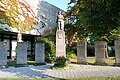
War memorial in front of town hall

External links[]
 Media related to Neufahrn bei Freising at Wikimedia Commons
- Official website
 (in German)
| show Towns and municipalities in Freising (district) |
|---|
| show Authority control |
|---|
This Freising district location article is a stub. You can help Wikipedia by . |
Categories:
- Municipalities in Bavaria
- Freising (district)
- Upper Bavaria geography stubs