Zolling
Zolling | |
|---|---|
 Market square with the Church of Saint John the Baptist and maypole | |
 Coat of arms | |
show Location of Zolling within Freising district | |
 Zolling | |
| Coordinates: 48°27′N 11°46′E / 48.450°N 11.767°ECoordinates: 48°27′N 11°46′E / 48.450°N 11.767°E | |
| Country | Germany |
| State | Bavaria |
| Admin. region | Oberbayern |
| District | Freising |
| Municipal assoc. | Zolling |
| Government | |
| • Mayor (2020–26) | Helmut Priller[1] |
| Area | |
| • Total | 34.59 km2 (13.36 sq mi) |
| Elevation | 429 m (1,407 ft) |
| Population (2020-12-31)[2] | |
| • Total | 4,829 |
| • Density | 140/km2 (360/sq mi) |
| Time zone | UTC+01:00 (CET) |
| • Summer (DST) | UTC+02:00 (CEST) |
| Postal codes | 85406 |
| Dialling codes | 08167 |
| Vehicle registration | FS |
| Website | www.zolling.de |


Zolling is a municipality in the Bavarian district of Freising. Associated villages are: Anglberg, Flitzing, Thann, Palzing, Oberappersdorf, and Appersdorf.
Zolling lies 6 km to the north of Freising.
Gallery[]

Zolling power plant
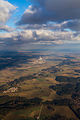
Bird's eye view of Zolling with its power plant
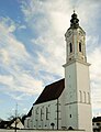
St. John's church in Zolling


References[]
- ^ Liste der ersten Bürgermeister/Oberbürgermeister in kreisangehörigen Gemeinden, Bayerisches Landesamt für Statistik, 15 July 2021.
- ^ "Tabellenblatt "Daten 2", Statistischer Bericht A1200C 202041 Einwohnerzahlen der Gemeinden, Kreise und Regierungsbezirke". Bayerisches Landesamt für Statistik (in German). June 2021.
| show Towns and municipalities in Freising (district) |
|---|
| Authority control |
|---|
This Freising district location article is a stub. You can help Wikipedia by . |
Categories:
- Municipalities in Bavaria
- Freising (district)
- Upper Bavaria geography stubs